

List of National Natural Landmarks in West Virginia
Encyclopedia
This is a list of the National Natural Landmark
s (NNLs) in West Virginia
. There are 14 in all — 5 are wetland
s (bogs, swamps, etc.), 3 are forest
s, and 6 are limestone caves/karst
. (In addition, the Cranesville Swamp Preserve
is a NNL mostly in Garrett County, Maryland
, a portion of which extends into Preston County, West Virginia
.) Ten of the 14 NNLs are within the boundaries of the Monongahela National Forest
, although this does not necessarily mean they are on public land.
( Vol. 71, No. 138 / Wednesday, July 19, 2006), Swago Karst Area (in Pocahontas County) was removed by the Department of the Interior from NNL designation in response to owner requests. Its citation formerly read: "A classic illustration of features associated with karst topography and terrain, including caverns and other passages. Three miles west of Marlinton."
National Natural Landmark
The National Natural Landmark program recognizes and encourages the conservation of outstanding examples of the natural history of the United States. It is the only natural areas program of national scope that identifies and recognizes the best examples of biological and geological features in...
s (NNLs) in West Virginia
West Virginia
West Virginia is a state in the Appalachian and Southeastern regions of the United States, bordered by Virginia to the southeast, Kentucky to the southwest, Ohio to the northwest, Pennsylvania to the northeast and Maryland to the east...
. There are 14 in all — 5 are wetland
Wetland
A wetland is an area of land whose soil is saturated with water either permanently or seasonally. Wetlands are categorised by their characteristic vegetation, which is adapted to these unique soil conditions....
s (bogs, swamps, etc.), 3 are forest
Forest
A forest, also referred to as a wood or the woods, is an area with a high density of trees. As with cities, depending where you are in the world, what is considered a forest may vary significantly in size and have various classification according to how and what of the forest is composed...
s, and 6 are limestone caves/karst
KARST
Kilometer-square Area Radio Synthesis Telescope is a Chinese telescope project to which FAST is a forerunner. KARST is a set of large spherical reflectors on karst landforms, which are bowlshaped limestone sinkholes named after the Kras region in Slovenia and Northern Italy. It will consist of...
. (In addition, the Cranesville Swamp Preserve
Cranesville Swamp Preserve
Cranesville Swamp Preserve is a preserve situated in Preston County, West Virginia and Garrett County, Maryland. It is one of the few remaining boreal bogs in the southern United States,...
is a NNL mostly in Garrett County, Maryland
Garrett County, Maryland
Garrett County is the westernmost county of the U.S. state of Maryland. Created from Allegany County, Maryland in 1872 it was the last Maryland county to be formed. It was named for John Work Garrett , railroad executive, industrialist, and financier. Garrett served as president of the Baltimore...
, a portion of which extends into Preston County, West Virginia
Preston County, West Virginia
As of the census of 2000, there were 29,334 people, 11,544 households, and 8,357 families residing in the county. The population density was 45 people per square mile . There were 13,444 housing units at an average density of 21 per square mile...
.) Ten of the 14 NNLs are within the boundaries of the Monongahela National Forest
Monongahela National Forest
The Monongahela National Forest is a national forest located in the Allegheny Mountains of eastern West Virginia, USA. It protects over of federally-owned land within a proclamation boundary that includes much of the Potomac Highlands Region and portions of 10 counties.The MNF includes some...
, although this does not necessarily mean they are on public land.
| Name | Image | Date | Location | County | Description | |
|---|---|---|---|---|---|---|
| 1 | Big Run Bog | 1974 | Tucker Tucker County, West Virginia As of the census of 2000, there were 7,321 people, 3,052 households, and 2,121 families residing in the county. The population density was 18 people per square mile . There were 4,634 housing units at an average density of 11 per square mile... |
Wetland | ||
| 2 | Blister Run Swamp | 1974 | Pocahontas Pocahontas County, West Virginia As of the census of 2000, there were 9,131 people, 835 households, and 527 families residing in the county. The population density was 10 people per square mile . There were 7,594 housing units at an average density of 8 per square mile... |
Wetland | ||
| 3 | Canaan Valley Canaan Valley Canaan Valley is an oval, bowl-like upland valley in northeastern Tucker County, West Virginia, USA. Within it are extensive wetlands and the headwaters of the Blackwater River which spills out of the valley at Blackwater Falls... |
1974 | Tucker Tucker County, West Virginia As of the census of 2000, there were 7,321 people, 3,052 households, and 2,121 families residing in the county. The population density was 18 people per square mile . There were 4,634 housing units at an average density of 11 per square mile... |
Wetland | ||
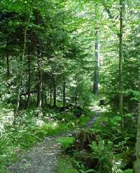
| 4 | Cathedral State Park Cathedral State Park Cathedral State Park is the largest virgin timber tract remaining in West Virginia. Located on about one mile east of the town of Aurora, Cathedral is a mixed forest of predominantly eastern hemlock.... |
1965 | Preston Preston County, West Virginia As of the census of 2000, there were 29,334 people, 11,544 households, and 8,357 families residing in the county. The population density was 45 people per square mile . There were 13,444 housing units at an average density of 21 per square mile... |
Forest | ||
| 5 | Cranberry Glades Botanical Area Cranberry Glades Botanical Area Cranberry Glades — also known simply as The Glades — are a cluster of five small, boreal-type bogs in southwestern Pocahontas County, West Virginia, USA. This area, high in the Allegheny Mountains at about , is protected as the Cranberry Glades Botanical Area, part of the Monongahela National Forest... |
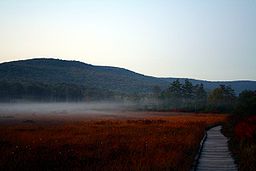 |
1974 | Pocahontas Pocahontas County, West Virginia As of the census of 2000, there were 9,131 people, 835 households, and 527 families residing in the county. The population density was 10 people per square mile . There were 7,594 housing units at an average density of 8 per square mile... |
Wetland | |
| 6 | Fisher Spring Run Bog | 1974 | Grant Grant County, West Virginia As of the census of 2000, there were 11,299 people, 4,591 households, and 3,273 families residing in the county. The population density was 24 people per square mile . There were 6,105 housing units at an average density of 13 per square mile... |
Wetland | ||
| 7 | Gaudineer Scenic Area Gaudineer Scenic Area The Gaudineer Scenic Area is a scenic area and National Natural Landmark in the Monongahela National Forest . It is situated just north of Gaudineer Knob of Shavers Mountain on the border of Randolph and Pocahontas Counties, West Virginia, USA, about northwest of the town of... |
 |
1974 | Randolph Randolph County, West Virginia As of the census of 2000, there were 28,262 people, 11,072 households, and 7,661 families residing in the county. The population density was 27 people per square mile . There were 13,478 housing units at an average density of 13 per square mile... , Pocahontas Pocahontas County, West Virginia As of the census of 2000, there were 9,131 people, 835 households, and 527 families residing in the county. The population density was 10 people per square mile . There were 7,594 housing units at an average density of 8 per square mile... |
Forest | |
| 8 | Germany Valley Karst Area Germany Valley Germany Valley is a scenic upland valley high in the Allegheny Mountains of eastern West Virginia originally settled by German farmers in the mid-18th Century... |
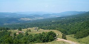 |
1973 | Pendleton Pendleton County, West Virginia As of the census of 2000, there were 8,196 people, 3,350 households, and 2,355 families residing in the county. The population density was 12 people per square mile . There were 5,102 housing units at an average density of 7 per square mile... |
Karst | |
| 9 | Greenville Saltpeter Cave | 1973 | Monroe Monroe County, West Virginia As of the census of 2000, there were 14,583 people, 5,447 households, and 3,883 families residing in the county. The population density was 31 people per square mile . There were 7,267 housing units at an average density of 15 per square mile... |
Cave | ||
| 10 | Lost World Caverns Lost World Caverns Lost World Caverns, located just outside of Lewisburg, West Virginia, is an underground natural series of caverns. In November 1973, the caverns were registered as a National Natural Landmark as they "feature terraced pedestal-like stalagmites, flowstone, curtains, rimstone, domepits, and... |
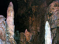 |
1973 | Greenbrier Greenbrier County, West Virginia As of the census of 2000, there were 34,453 people, 14,571 households, and 9,922 families residing in the county. The population density was 34 people per square mile . There were 17,644 housing units at an average density of 17 per square mile... |
Cave | |
| 11 | Organ Cave System | 1973 | Greenbrier Greenbrier County, West Virginia As of the census of 2000, there were 34,453 people, 14,571 households, and 9,922 families residing in the county. The population density was 34 people per square mile . There were 17,644 housing units at an average density of 17 per square mile... |
Cave | ||
| 12 | Shavers Mountain Spruce-Hemlock Stand | 1974 | Randolph Randolph County, West Virginia As of the census of 2000, there were 28,262 people, 11,072 households, and 7,661 families residing in the county. The population density was 27 people per square mile . There were 13,478 housing units at an average density of 13 per square mile... |
Forest | ||
| 13 | Sinnett-Thorn Mountain Cave System | 1973 | Pendleton Pendleton County, West Virginia As of the census of 2000, there were 8,196 people, 3,350 households, and 2,355 families residing in the county. The population density was 12 people per square mile . There were 5,102 housing units at an average density of 7 per square mile... |
Cave/karst | ||
| 14 | Swago Karst Area | 1973–2006 | Pocahontas Pocahontas County, West Virginia As of the census of 2000, there were 9,131 people, 835 households, and 527 families residing in the county. The population density was 10 people per square mile . There were 7,594 housing units at an average density of 8 per square mile... |
Karst | ||
De-designation
According to a notice in the Federal RegisterFederal Register
The Federal Register , abbreviated FR, or sometimes Fed. Reg.) is the official journal of the federal government of the United States that contains most routine publications and public notices of government agencies...
( Vol. 71, No. 138 / Wednesday, July 19, 2006), Swago Karst Area (in Pocahontas County) was removed by the Department of the Interior from NNL designation in response to owner requests. Its citation formerly read: "A classic illustration of features associated with karst topography and terrain, including caverns and other passages. Three miles west of Marlinton."
See also
- List of National Natural Landmarks
- List of National Historic Landmarks in West Virginia
- National Register of Historic Places listings in West Virginia