
Cross-Bronx Expressway
Encyclopedia
The Cross Bronx Expressway is a major expressway (freeway) in the New York City
borough of the Bronx
, conceived by Robert Moses
and built between 1948 and 1972. It carries traffic on Interstate 95
through the city, and serves as a portion of Interstate 295
toward Long Island
; a portion is also designated U.S. Route 1.
The Cross Bronx begins at the Alexander Hamilton Bridge
over the Harlem River
, where the Trans-Manhattan Expressway
continues west across Upper Manhattan
to the George Washington Bridge
. While I-95 leaves at the Bruckner Interchange
in Throgs Neck, following the Bruckner Expressway
and New England Thruway
to Connecticut
, the Cross Bronx Expressway Extension continues east, carrying I-295 to the merge with the Throgs Neck Expressway near the Throgs Neck Bridge
.
The Cross Bronx Expressway was an engineering marvel, being the first highway built through a crowded urban environment; the most expensive mile of road ever built is part of the Cross Bronx, costing $40,000,000. At one point during construction, Moses' crews had to support the Grand Concourse
(a major surface thoroughfare), a subway
line and an elevated train line while the expressway was laboriously pushed through. However, the highway has severe traffic problems, and its construction has also been blamed for devastating a number of low-income neighborhoods in the South Bronx
.
 The Cross Bronx Expressway begins at the eastern end of the Alexander Hamilton Bridge
as a continuation of the Trans-Manhattan Expressway
and officially designated as both I-95 and US 1. Immediately after coming off the bridge, there is an interchange with the Major Deegan Expressway
(I-87) for Yankee Stadium
and points upstate. The highway soon intersects with Webster Avenue
at a partial interchange allowing eastbound vehicles to exit and westbound ones to enter. Northbound US 1 leaves the Cross Bronx Expressway at this exit. About one and half miles later, comes a pair of closely spaced interchanges for the Sheridan Expressway (I-895) and the Bronx River Parkway
. The exit for the Sheridan Expressway is an incomplete interchange and allows access from northbound and to southbound I-95 only.
The Cross Bronx Expressway reaches the Bruckner Interchange
two miles (3 km) later. Going eastbound (I-95 northbound), the interchange allows access to southbound I-678, northbound I-95 (Bruckner Expressway
) and southbound I-295. I-95 leaves the Cross Bronx Expressway here and continues north along the Bruckner Expressway. The Cross Bronx Expressway continues east of the interchange as I-295, which begins here. The Cross Bronx ends 1.5 miles (2.4 km) later at the Throgs Neck Expressway, where traffic from Interstate 695
merges on towards the Throgs Neck Bridge
.
 The 1929 Report on Highway Traffic Conditions and Proposed Traffic Relief Measures for the City of New York was the first citywide traffic study, classifying a number of projects that had been proposed by local interests. A "Cross-Bronx Route" along 161st and 163rd Streets was one of two proposed facilities, along with the "Nassau Boulevard" (which became the Long Island Expressway), picked by borough engineers as examples of important projects. Although this routing was south of the present Cross Bronx Expressway, the report did suggest a "New Cross-Bronx Artery" near the present expressway that would link the Washington Bridge
with the Clason Point Ferry to Queens
. Though it would not be built to freeway standards, it would be 60 feet (18 m) wide with grade separation
s "where considered necessary and desirable". The George Washington Bridge
then under construction was cited among reasons to build the highway, which would help connect New Jersey
to Long Island
via the bridges and ferry.
The New York City Planning Commission adopted a plan in late 1940 for a network of highways. Except for the Bronx and Pelham Parkway, which lay to the north, no cross-Bronx highway had been built. The report stated that the "Bronx Crosstown Highway", which would now connect on the east end to the Bronx-Whitestone Bridge (which had replaced the Clason Point Ferry), was "an essential part of a desirable highway pattern", taking traffic from the George Washington Bridge to Long Island and New England
. The cost was estimated at $17,000,000, higher than most improvements because of the "topographical conditions, high land values, and heavily built-up areas".
In 1936, the Regional Plan Association
(RPA) proposed a Cross Bronx highway which would connect the George Washington
, Triborough, and Bronx-Whitestone Bridges, as well as access to points north to New England. Five years later, the New York City Planning Planning Department recommended construction of the "Bronx Crosstown Highway."
Robert Moses
proposed a six-lane expressway to run through the middle of the Bronx in 1945. This project proved to be one of the most difficult expressway projects of the time: construction required blasting through ridges, crossing valleys and redirecting small rivers. In doing so, minimal disruption to the apartment buildings that topped the ridges in the area of Grand Concourse
was a priority. Moreover, the expressway had to cross 113 streets, seven expressways and parkways (some of which were under construction), one subway line, five elevated lines, three commuter rail lines, and hundreds of utility, water and sewer lines, none of which could be interrupted.
Construction began in 1948. The roadway was carefully constructed with 12 feet (3.7 m) lanes and 10 feet (3 m) cobblestone shoulders. In 1963, the last of the three sections of roadway between the Alexander Hamilton and Throgs Neck Bridges were finished, completing the Cross Bronx Expressway.
 The first portion, from the Bronx River Parkway
east to the Bruckner Interchange
, opened on November 5, 1955, at the same time as parts of the Queens Midtown and Major Deegan Expressway
s. When the Throgs Neck Bridge
opened on January 11, 1961, the Cross Bronx was extended east as one of its two northern approaches. (The extension was part of I-78 until 1970, when it became I-295, its current designation.) A one-mile (1.5 km) western extension to a temporary interchange with Boston Road opened on April 23, 1956, and on April 27, 1960, another 1.2-mile (2 km) piece opened, taking the road west to Webster Avenue. The short 0.6-mile (1 km) piece from Webster Avenue west to Jerome Avenue opened on February 10, 1961. With the opening of the Alexander Hamilton Bridge
in April 1963, the $128 million Cross Bronx was completed. This was, however, not the end of construction; the $12.6 million Highbridge Interchange with the Major Deegan Expressway
(I-87) opened in November 1964, and a $68 million reconstruction of the Bruckner Interchange
, allowing Bruckner Expressway
(I-95/I-278) traffic to bypass the old traffic circle
, opened on January 2, 1972. (Cross Bronx traffic passing through to the Throgs Neck Bridge had been able to avoid the circle, but drivers taking the Bruckner in either direction, including those bound for New England
, had to exit onto the surface.)
, with the prominent example being the neighborhood of Tremont. In Robert Caro
's The Power Broker
, the author argues that Moses intentionally directed the expressway through this neighborhood, even though there was a more viable option only one block south. Many of the neighborhoods it runs through have been continually poor since before its construction, primarily due to the lowered property value caused by the Expressway. This is partially responsible for the public opposition to many other planned expressways in New York City
that were later cancelled – in particular, the Lower Manhattan Expressway
.
via the George Washington Bridge
, Long Island
via the Throgs Neck
and Whitestone Bridges
, Upstate New York via Interstate 87
northbound and the Bronx River Parkway
, Manhattan via Interstate 87
southbound to the Robert F. Kennedy (Triborough) Bridge, and New England
via the New England Thruway
(Interstate 95
) and the Hutchinson River Parkway
.
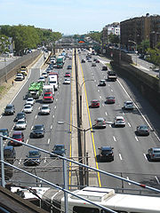
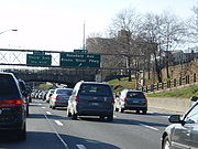
However, the expressway is known for its extreme traffic problems; on a typical day 145,000 vehicles travel on the six lanes of highway the road contains, and it is not uncommon for truckers to use the Cross-Westchester Expressway to the Major Deegan Expressway
to get around this stretch of I-95
. Proposals have been made to add a second deck to the road, although to no avail.
In both 2008 and 2007, Inrix
cited the Cross Bronx Expressway's west-bound exit 4B (Bronx River Parkway
) as being the worst intersection in the US. In 2008, the expressway's exits included three out of the top four on the list, and four of the top five in 2007.
As an option to using the Cross Bronx Expressway to accessing the George Washington Bridge from the north, many car services and chauffeur services recommend using the Cross County Parkway, which merges into the Sawmill Parkway and then the Henry Hudson Parkway. According to industry experts, this route bypasses much of the Bronx bound traffic found on the Cross Bronx Expressway.
New York City
New York is the most populous city in the United States and the center of the New York Metropolitan Area, one of the most populous metropolitan areas in the world. New York exerts a significant impact upon global commerce, finance, media, art, fashion, research, technology, education, and...
borough of the Bronx
The Bronx
The Bronx is the northernmost of the five boroughs of New York City. It is also known as Bronx County, the last of the 62 counties of New York State to be incorporated...
, conceived by Robert Moses
Robert Moses
Robert Moses was the "master builder" of mid-20th century New York City, Long Island, Rockland County, and Westchester County, New York. As the shaper of a modern city, he is sometimes compared to Baron Haussmann of Second Empire Paris, and is one of the most polarizing figures in the history of...
and built between 1948 and 1972. It carries traffic on Interstate 95
Interstate 95 in New York
Interstate 95 is a part of the Interstate Highway System that runs from Miami, Florida, to the Canada – United States border near Houlton, Maine. In the U.S. state of New York, I-95 extends from the George Washington Bridge in New York City to the Connecticut state line at Port Chester...
through the city, and serves as a portion of Interstate 295
Interstate 295 (New York)
Interstate 295 is a connector route within New York City. Measuring 9.10 miles in length, I-295 travels from the Bruckner Interchange, a junction with I-95/I-278/I-678 in The Bronx, across the toll Throgs Neck Bridge to the Grand Central Parkway in Queens...
toward Long Island
Long Island
Long Island is an island located in the southeast part of the U.S. state of New York, just east of Manhattan. Stretching northeast into the Atlantic Ocean, Long Island contains four counties, two of which are boroughs of New York City , and two of which are mainly suburban...
; a portion is also designated U.S. Route 1.
The Cross Bronx begins at the Alexander Hamilton Bridge
Alexander Hamilton Bridge
The Alexander Hamilton Bridge carries eight lanes of traffic over the Harlem River in New York City between the boroughs of Manhattan and the Bronx, connecting the Trans-Manhattan Expressway in the Washington Heights section of Manhattan and the Cross-Bronx Expressway, as part of Interstate 95...
over the Harlem River
Harlem River
The Harlem River is a navigable tidal strait in New York City, USA that flows 8 miles between the Hudson River and the East River, separating the boroughs of Manhattan and the Bronx...
, where the Trans-Manhattan Expressway
Trans-Manhattan Expressway
The Trans-Manhattan Expressway or George Washington Bridge Expressway is a highway in New York City that is part of the Interstate Highway System. Though few of the millions who use it or live near it have ever heard the name, it is probably one of the shortest, busiest, and most congested named...
continues west across Upper Manhattan
Upper Manhattan
Upper Manhattan denotes the more northerly region of the New York City Borough of Manhattan. Its southern boundary may be defined anywhere between 59th Street and 155th Street. Between these two extremes lies the most common definitions of Upper Manhattan as Manhattan above 96th Street...
to the George Washington Bridge
George Washington Bridge
The George Washington Bridge is a suspension bridge spanning the Hudson River, connecting the Washington Heights neighborhood in the borough of Manhattan in New York City to Fort Lee, Bergen County, New Jersey. Interstate 95 and U.S. Route 1/9 cross the river via the bridge. U.S...
. While I-95 leaves at the Bruckner Interchange
Bruckner Interchange
The Bruckner Interchange is a complex interchange at the intersection of the Bruckner Expressway, Cross Bronx Expressway, Hutchinson River Expressway, and Hutchinson River Parkway in the New York City borough of the Bronx, United States...
in Throgs Neck, following the Bruckner Expressway
Bruckner Expressway
The Bruckner Expressway is a freeway in The Bronx. It carries Interstate 278 and Interstate 95 from the Robert F. Kennedy Bridge to the south end of the New England Thruway at the Pelham Parkway interchange....
and New England Thruway
New England Thruway
The New England Thruway is a portion of the U.S. Interstate highway system and of the New York State Thruway, within and operated by the New York State Thruway Authority, linking New York City with New England, specifically with southwestern Connecticut...
to Connecticut
Connecticut
Connecticut is a state in the New England region of the northeastern United States. It is bordered by Rhode Island to the east, Massachusetts to the north, and the state of New York to the west and the south .Connecticut is named for the Connecticut River, the major U.S. river that approximately...
, the Cross Bronx Expressway Extension continues east, carrying I-295 to the merge with the Throgs Neck Expressway near the Throgs Neck Bridge
Throgs Neck Bridge
The Throgs Neck Bridge is a suspension bridge opened on January 11, 1961, which carries Interstate 295 over the East River where it meets the Long Island Sound. The bridge connects the Throggs Neck section of the Bronx with the Bay Terrace section of Queens...
.
The Cross Bronx Expressway was an engineering marvel, being the first highway built through a crowded urban environment; the most expensive mile of road ever built is part of the Cross Bronx, costing $40,000,000. At one point during construction, Moses' crews had to support the Grand Concourse
Grand Concourse (Bronx)
The Grand Concourse is a major thoroughfare in the borough of the Bronx in New York City...
(a major surface thoroughfare), a subway
New York City Subway
The New York City Subway is a rapid transit system owned by the City of New York and leased to the New York City Transit Authority, a subsidiary agency of the Metropolitan Transportation Authority and also known as MTA New York City Transit...
line and an elevated train line while the expressway was laboriously pushed through. However, the highway has severe traffic problems, and its construction has also been blamed for devastating a number of low-income neighborhoods in the South Bronx
South Bronx
The South Bronx is an area of the New York City borough of The Bronx. The neighborhoods of Tremont, University Heights, Highbridge, Morrisania, Soundview, Hunts Point, and Castle Hill are sometimes considered part of the South Bronx....
.
Route description
Alexander Hamilton Bridge
The Alexander Hamilton Bridge carries eight lanes of traffic over the Harlem River in New York City between the boroughs of Manhattan and the Bronx, connecting the Trans-Manhattan Expressway in the Washington Heights section of Manhattan and the Cross-Bronx Expressway, as part of Interstate 95...
as a continuation of the Trans-Manhattan Expressway
Trans-Manhattan Expressway
The Trans-Manhattan Expressway or George Washington Bridge Expressway is a highway in New York City that is part of the Interstate Highway System. Though few of the millions who use it or live near it have ever heard the name, it is probably one of the shortest, busiest, and most congested named...
and officially designated as both I-95 and US 1. Immediately after coming off the bridge, there is an interchange with the Major Deegan Expressway
Major Deegan Expressway
The Major Deegan Expressway is a north–south expressway in the New York City borough of the Bronx...
(I-87) for Yankee Stadium
Yankee Stadium
Yankee Stadium was a stadium located in The Bronx in New York City, New York. It was the home ballpark of the New York Yankees from 1923 to 1973 and from 1976 to 2008. The stadium hosted 6,581 Yankees regular season home games during its 85-year history. It was also the former home of the New York...
and points upstate. The highway soon intersects with Webster Avenue
Webster Avenue
Webster Avenue is one of the longest thoroughfares in the Bronx. It stretches for 5.8 miles from Melrose to Woodlawn . The road starts at an intersection with Melrose Avenue, East 165th Street, Brook Avenue and Park Avenue in Melrose, ending at Nereid Avenue and East 240th Street in the town of...
at a partial interchange allowing eastbound vehicles to exit and westbound ones to enter. Northbound US 1 leaves the Cross Bronx Expressway at this exit. About one and half miles later, comes a pair of closely spaced interchanges for the Sheridan Expressway (I-895) and the Bronx River Parkway
Bronx River Parkway
The Bronx River Parkway is a long parkway in downstate New York. It is named for the nearby Bronx River, which it parallels. The southern terminus of the parkway is at Story Avenue near Bruckner Expressway in the Bronx neighborhood of Soundview...
. The exit for the Sheridan Expressway is an incomplete interchange and allows access from northbound and to southbound I-95 only.
The Cross Bronx Expressway reaches the Bruckner Interchange
Bruckner Interchange
The Bruckner Interchange is a complex interchange at the intersection of the Bruckner Expressway, Cross Bronx Expressway, Hutchinson River Expressway, and Hutchinson River Parkway in the New York City borough of the Bronx, United States...
two miles (3 km) later. Going eastbound (I-95 northbound), the interchange allows access to southbound I-678, northbound I-95 (Bruckner Expressway
Bruckner Expressway
The Bruckner Expressway is a freeway in The Bronx. It carries Interstate 278 and Interstate 95 from the Robert F. Kennedy Bridge to the south end of the New England Thruway at the Pelham Parkway interchange....
) and southbound I-295. I-95 leaves the Cross Bronx Expressway here and continues north along the Bruckner Expressway. The Cross Bronx Expressway continues east of the interchange as I-295, which begins here. The Cross Bronx ends 1.5 miles (2.4 km) later at the Throgs Neck Expressway, where traffic from Interstate 695
Interstate 695 (New York)
Interstate 695 is an auxiliary Interstate Highway in the New York City borough of the Bronx. It serves as a connector between I-95 and I-295 near the Throgs Neck Bridge towards Queens and Long Island...
merges on towards the Throgs Neck Bridge
Throgs Neck Bridge
The Throgs Neck Bridge is a suspension bridge opened on January 11, 1961, which carries Interstate 295 over the East River where it meets the Long Island Sound. The bridge connects the Throggs Neck section of the Bronx with the Bay Terrace section of Queens...
.
History
Washington Bridge
The Washington Bridge carries six lanes of traffic over the Harlem River in New York City between the boroughs of Manhattan and the Bronx, connecting 181st Street and Amsterdam Avenue in the Washington Heights section of Manhattan to University Avenue in the Morris Heights section of the Bronx...
with the Clason Point Ferry to Queens
Queens
Queens is the easternmost of the five boroughs of New York City. The largest borough in area and the second-largest in population, it is coextensive with Queens County, an administrative division of New York state, in the United States....
. Though it would not be built to freeway standards, it would be 60 feet (18 m) wide with grade separation
Grade separation
Grade separation is the method of aligning a junction of two or more transport axes at different heights so that they will not disrupt the traffic flow on other transit routes when they cross each other. The composition of such transport axes does not have to be uniform; it can consist of a...
s "where considered necessary and desirable". The George Washington Bridge
George Washington Bridge
The George Washington Bridge is a suspension bridge spanning the Hudson River, connecting the Washington Heights neighborhood in the borough of Manhattan in New York City to Fort Lee, Bergen County, New Jersey. Interstate 95 and U.S. Route 1/9 cross the river via the bridge. U.S...
then under construction was cited among reasons to build the highway, which would help connect New Jersey
New Jersey
New Jersey is a state in the Northeastern and Middle Atlantic regions of the United States. , its population was 8,791,894. It is bordered on the north and east by the state of New York, on the southeast and south by the Atlantic Ocean, on the west by Pennsylvania and on the southwest by Delaware...
to Long Island
Long Island
Long Island is an island located in the southeast part of the U.S. state of New York, just east of Manhattan. Stretching northeast into the Atlantic Ocean, Long Island contains four counties, two of which are boroughs of New York City , and two of which are mainly suburban...
via the bridges and ferry.
The New York City Planning Commission adopted a plan in late 1940 for a network of highways. Except for the Bronx and Pelham Parkway, which lay to the north, no cross-Bronx highway had been built. The report stated that the "Bronx Crosstown Highway", which would now connect on the east end to the Bronx-Whitestone Bridge (which had replaced the Clason Point Ferry), was "an essential part of a desirable highway pattern", taking traffic from the George Washington Bridge to Long Island and New England
New England
New England is a region in the northeastern corner of the United States consisting of the six states of Maine, New Hampshire, Vermont, Massachusetts, Rhode Island, and Connecticut...
. The cost was estimated at $17,000,000, higher than most improvements because of the "topographical conditions, high land values, and heavily built-up areas".
In 1936, the Regional Plan Association
Regional Plan Association
The Regional Plan Association is an independent, not-for-profit regional planning organization, founded in 1922, that focuses on recommendations to improve the quality of life and economic competitiveness of the 31-county New York-New Jersey-Connecticut region...
(RPA) proposed a Cross Bronx highway which would connect the George Washington
George Washington Bridge
The George Washington Bridge is a suspension bridge spanning the Hudson River, connecting the Washington Heights neighborhood in the borough of Manhattan in New York City to Fort Lee, Bergen County, New Jersey. Interstate 95 and U.S. Route 1/9 cross the river via the bridge. U.S...
, Triborough, and Bronx-Whitestone Bridges, as well as access to points north to New England. Five years later, the New York City Planning Planning Department recommended construction of the "Bronx Crosstown Highway."
Robert Moses
Robert Moses
Robert Moses was the "master builder" of mid-20th century New York City, Long Island, Rockland County, and Westchester County, New York. As the shaper of a modern city, he is sometimes compared to Baron Haussmann of Second Empire Paris, and is one of the most polarizing figures in the history of...
proposed a six-lane expressway to run through the middle of the Bronx in 1945. This project proved to be one of the most difficult expressway projects of the time: construction required blasting through ridges, crossing valleys and redirecting small rivers. In doing so, minimal disruption to the apartment buildings that topped the ridges in the area of Grand Concourse
Grand Concourse (Bronx)
The Grand Concourse is a major thoroughfare in the borough of the Bronx in New York City...
was a priority. Moreover, the expressway had to cross 113 streets, seven expressways and parkways (some of which were under construction), one subway line, five elevated lines, three commuter rail lines, and hundreds of utility, water and sewer lines, none of which could be interrupted.
Construction began in 1948. The roadway was carefully constructed with 12 feet (3.7 m) lanes and 10 feet (3 m) cobblestone shoulders. In 1963, the last of the three sections of roadway between the Alexander Hamilton and Throgs Neck Bridges were finished, completing the Cross Bronx Expressway.
Bronx River Parkway
The Bronx River Parkway is a long parkway in downstate New York. It is named for the nearby Bronx River, which it parallels. The southern terminus of the parkway is at Story Avenue near Bruckner Expressway in the Bronx neighborhood of Soundview...
east to the Bruckner Interchange
Bruckner Interchange
The Bruckner Interchange is a complex interchange at the intersection of the Bruckner Expressway, Cross Bronx Expressway, Hutchinson River Expressway, and Hutchinson River Parkway in the New York City borough of the Bronx, United States...
, opened on November 5, 1955, at the same time as parts of the Queens Midtown and Major Deegan Expressway
Major Deegan Expressway
The Major Deegan Expressway is a north–south expressway in the New York City borough of the Bronx...
s. When the Throgs Neck Bridge
Throgs Neck Bridge
The Throgs Neck Bridge is a suspension bridge opened on January 11, 1961, which carries Interstate 295 over the East River where it meets the Long Island Sound. The bridge connects the Throggs Neck section of the Bronx with the Bay Terrace section of Queens...
opened on January 11, 1961, the Cross Bronx was extended east as one of its two northern approaches. (The extension was part of I-78 until 1970, when it became I-295, its current designation.) A one-mile (1.5 km) western extension to a temporary interchange with Boston Road opened on April 23, 1956, and on April 27, 1960, another 1.2-mile (2 km) piece opened, taking the road west to Webster Avenue. The short 0.6-mile (1 km) piece from Webster Avenue west to Jerome Avenue opened on February 10, 1961. With the opening of the Alexander Hamilton Bridge
Alexander Hamilton Bridge
The Alexander Hamilton Bridge carries eight lanes of traffic over the Harlem River in New York City between the boroughs of Manhattan and the Bronx, connecting the Trans-Manhattan Expressway in the Washington Heights section of Manhattan and the Cross-Bronx Expressway, as part of Interstate 95...
in April 1963, the $128 million Cross Bronx was completed. This was, however, not the end of construction; the $12.6 million Highbridge Interchange with the Major Deegan Expressway
Major Deegan Expressway
The Major Deegan Expressway is a north–south expressway in the New York City borough of the Bronx...
(I-87) opened in November 1964, and a $68 million reconstruction of the Bruckner Interchange
Bruckner Interchange
The Bruckner Interchange is a complex interchange at the intersection of the Bruckner Expressway, Cross Bronx Expressway, Hutchinson River Expressway, and Hutchinson River Parkway in the New York City borough of the Bronx, United States...
, allowing Bruckner Expressway
Bruckner Expressway
The Bruckner Expressway is a freeway in The Bronx. It carries Interstate 278 and Interstate 95 from the Robert F. Kennedy Bridge to the south end of the New England Thruway at the Pelham Parkway interchange....
(I-95/I-278) traffic to bypass the old traffic circle
Traffic circle
A traffic circle or rotary is a type of circular intersection in which traffic must travel in one direction around a central island. In some countries, traffic entering the circle has the right-of-way and drivers in the circle must yield. In many other countries, traffic entering the circle must...
, opened on January 2, 1972. (Cross Bronx traffic passing through to the Throgs Neck Bridge had been able to avoid the circle, but drivers taking the Bruckner in either direction, including those bound for New England
New England
New England is a region in the northeastern corner of the United States consisting of the six states of Maine, New Hampshire, Vermont, Massachusetts, Rhode Island, and Connecticut...
, had to exit onto the surface.)
Controversy
Many have blamed the Cross Bronx Expressway for worsening the decay of neighborhoods in the South BronxSouth Bronx
The South Bronx is an area of the New York City borough of The Bronx. The neighborhoods of Tremont, University Heights, Highbridge, Morrisania, Soundview, Hunts Point, and Castle Hill are sometimes considered part of the South Bronx....
, with the prominent example being the neighborhood of Tremont. In Robert Caro
Robert Caro
Robert Allan Caro is an American journalist and author known for his celebrated biographies of United States political figures Robert Moses and Lyndon B. Johnson...
's The Power Broker
The Power Broker
The Power Broker: Robert Moses and the Fall of New York is a Pulitzer Prize-winning 1974 biography of Robert Moses, "New York City's Master Builder", by Robert Caro...
, the author argues that Moses intentionally directed the expressway through this neighborhood, even though there was a more viable option only one block south. Many of the neighborhoods it runs through have been continually poor since before its construction, primarily due to the lowered property value caused by the Expressway. This is partially responsible for the public opposition to many other planned expressways in New York City
New York City
New York is the most populous city in the United States and the center of the New York Metropolitan Area, one of the most populous metropolitan areas in the world. New York exerts a significant impact upon global commerce, finance, media, art, fashion, research, technology, education, and...
that were later cancelled – in particular, the Lower Manhattan Expressway
Lower Manhattan Expressway
The Lower Manhattan Expressway was a controversial plan for an expressway through lower Manhattan originally conceived by Robert Moses in 1941, but delayed until the early 1960s...
.
Traffic problems
The expressway is one of the main routes for shipping and transportation through New York City due to its connections with New JerseyNew Jersey
New Jersey is a state in the Northeastern and Middle Atlantic regions of the United States. , its population was 8,791,894. It is bordered on the north and east by the state of New York, on the southeast and south by the Atlantic Ocean, on the west by Pennsylvania and on the southwest by Delaware...
via the George Washington Bridge
George Washington Bridge
The George Washington Bridge is a suspension bridge spanning the Hudson River, connecting the Washington Heights neighborhood in the borough of Manhattan in New York City to Fort Lee, Bergen County, New Jersey. Interstate 95 and U.S. Route 1/9 cross the river via the bridge. U.S...
, Long Island
Long Island
Long Island is an island located in the southeast part of the U.S. state of New York, just east of Manhattan. Stretching northeast into the Atlantic Ocean, Long Island contains four counties, two of which are boroughs of New York City , and two of which are mainly suburban...
via the Throgs Neck
Throgs Neck Bridge
The Throgs Neck Bridge is a suspension bridge opened on January 11, 1961, which carries Interstate 295 over the East River where it meets the Long Island Sound. The bridge connects the Throggs Neck section of the Bronx with the Bay Terrace section of Queens...
and Whitestone Bridges
Bronx Whitestone Bridge
The Bronx–Whitestone Bridge is a suspension bridge in New York City that crosses the East River and connects the boroughs of Queens on Long Island and The Bronx via Interstate 678...
, Upstate New York via Interstate 87
Interstate 87
Interstate 87 is a Interstate Highway located entirely within New York State in the United States of America. I-87 is the longest intrastate Interstate highway in the Interstate Highway System. Its southern end is at the Bronx approaches of the Robert F. Kennedy Bridge in New York City...
northbound and the Bronx River Parkway
Bronx River Parkway
The Bronx River Parkway is a long parkway in downstate New York. It is named for the nearby Bronx River, which it parallels. The southern terminus of the parkway is at Story Avenue near Bruckner Expressway in the Bronx neighborhood of Soundview...
, Manhattan via Interstate 87
Interstate 87
Interstate 87 is a Interstate Highway located entirely within New York State in the United States of America. I-87 is the longest intrastate Interstate highway in the Interstate Highway System. Its southern end is at the Bronx approaches of the Robert F. Kennedy Bridge in New York City...
southbound to the Robert F. Kennedy (Triborough) Bridge, and New England
New England
New England is a region in the northeastern corner of the United States consisting of the six states of Maine, New Hampshire, Vermont, Massachusetts, Rhode Island, and Connecticut...
via the New England Thruway
New England Thruway
The New England Thruway is a portion of the U.S. Interstate highway system and of the New York State Thruway, within and operated by the New York State Thruway Authority, linking New York City with New England, specifically with southwestern Connecticut...
(Interstate 95
Interstate 95 in New York
Interstate 95 is a part of the Interstate Highway System that runs from Miami, Florida, to the Canada – United States border near Houlton, Maine. In the U.S. state of New York, I-95 extends from the George Washington Bridge in New York City to the Connecticut state line at Port Chester...
) and the Hutchinson River Parkway
Hutchinson River Parkway
The Hutchinson River Parkway is a north–south parkway in southern New York, United States. It extends for from the massive Bruckner Interchange in the Throgs Neck section of the Bronx to the New York – Connecticut state line at Rye Brook...
.
However, the expressway is known for its extreme traffic problems; on a typical day 145,000 vehicles travel on the six lanes of highway the road contains, and it is not uncommon for truckers to use the Cross-Westchester Expressway to the Major Deegan Expressway
Major Deegan Expressway
The Major Deegan Expressway is a north–south expressway in the New York City borough of the Bronx...
to get around this stretch of I-95
Interstate 95 in New York
Interstate 95 is a part of the Interstate Highway System that runs from Miami, Florida, to the Canada – United States border near Houlton, Maine. In the U.S. state of New York, I-95 extends from the George Washington Bridge in New York City to the Connecticut state line at Port Chester...
. Proposals have been made to add a second deck to the road, although to no avail.
In both 2008 and 2007, Inrix
Inrix
INRIX is a software company which provides a variety of mobile applications and Internet services pertaining to traffic and navigation. INRIX provides historical and real-time traffic information to businesses and individuals in over 30 countries including the United States and much of Europe...
cited the Cross Bronx Expressway's west-bound exit 4B (Bronx River Parkway
Bronx River Parkway
The Bronx River Parkway is a long parkway in downstate New York. It is named for the nearby Bronx River, which it parallels. The southern terminus of the parkway is at Story Avenue near Bruckner Expressway in the Bronx neighborhood of Soundview...
) as being the worst intersection in the US. In 2008, the expressway's exits included three out of the top four on the list, and four of the top five in 2007.
As an option to using the Cross Bronx Expressway to accessing the George Washington Bridge from the north, many car services and chauffeur services recommend using the Cross County Parkway, which merges into the Sawmill Parkway and then the Henry Hudson Parkway. According to industry experts, this route bypasses much of the Bronx bound traffic found on the Cross Bronx Expressway.
Exit list
| Location | Mile | Exit | Destinations | Notes |
|---|---|---|---|---|
| Morris Heights Morris Heights, Bronx Morris Heights is a low income residential neighborhood located in the west Bronx. The neighborhood is part of Bronx Community Board 5. Its boundaries, starting from the north and moving clockwise are: West Burnside Avenue to the north, Jerome Avenue to the east, the Cross-Bronx Expressway to the... |
0.00 | Alexander Hamilton Bridge Alexander Hamilton Bridge The Alexander Hamilton Bridge carries eight lanes of traffic over the Harlem River in New York City between the boroughs of Manhattan and the Bronx, connecting the Trans-Manhattan Expressway in the Washington Heights section of Manhattan and the Cross-Bronx Expressway, as part of Interstate 95... over the Harlem River Harlem River The Harlem River is a navigable tidal strait in New York City, USA that flows 8 miles between the Hudson River and the East River, separating the boroughs of Manhattan and the Bronx... |
||
| 0.07 | 1C | |||
| 0.65 | 2A | Jerome Avenue Jerome Avenue Jerome Avenue is one of the longest thoroughfares in the New York City borough of the Bronx, New York, United States. The road is 5.6 miles long and stretches from Highbridge general area to Woodlawn. Both of these termini are with the Major Deegan Expressway which runs parallel to the west. Most... |
||
| Tremont Tremont, Bronx Tremont is a low income residential neighborhood geographically located in the west Bronx, New York City. The neighborhood is part of Bronx Community Board 5. Its boundaries, starting from the north and moving clockwise are: East 183rd Street to the north, Webster Avenue to the east, the... |
1.28 | 2B | East end of US 1 overlap; eastbound exit and westbound entrance | |
| 1.86 | 3 | Third Avenue | Westbound exit and eastbound entrance | |
| West Farms West Farms, Bronx West Farms is a residential neighborhood in a west central part of The Bronx, New York City, also known as the northeast corner of the South Bronx. The neighborhood is part of Bronx Community Board 6... |
2.64 | 4A | Eastbound exit and westbound entrance | |
| Soundview Soundview, Bronx Soundview is primarily a residential neighborhood geographically located in the South Central section of the Borough of The Bronx in New York City. The neighborhood is part of Bronx Community Board 9... |
3.00 | 4B | ||
| 3.70 | 5A | White Plains Road, Westchester Avenue | ||
| Castle Hill Castle Hill, Bronx Castle Hill is primarily a residential neighborhood geographically located in the South Central section of the borough of The Bronx in New York City. The neighborhood is part of Bronx Community Board 9... |
||||
| 5B | Castle Hill Avenue | Eastbound exit and westbound entrance | ||
| Throggs Neck | 5.05 | 6A | Eastbound exit and westbound entrance | |
| 5.05 | Westbound exit and eastbound entrance | |||
| 5.05 | East end of I-95 overlap; west end of I-295 overlap; eastbound exit and westbound entrance | |||
| 11 | Randall Avenue | |||
| 6.5 | Cross-Bronx Expressway ends at the Throgs Neck Expressway | |||