
Interstate 287
Encyclopedia
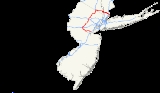
Interstate 287 is an auxiliary Interstate Highway in the U.S. state
s of New Jersey
and New York
. It is a partial beltway around New York City
, serving the northern half of New Jersey and the counties of Rockland
and Westchester
in New York. I-287, which is signed north–south in New Jersey and east–west in New York, follows a roughly horseshoe-shaped route from the New Jersey Turnpike
(I-95
) in Edison Township, New Jersey
clockwise to the New England Thruway
(I-95
) in Rye, New York, for 98.72 miles (158.87 km). Through New Jersey, I-287 runs west from its southern terminus in Edison through suburban areas. In Bridgewater Township
, the freeway takes a more northeasterly course, paralleled by US 202
. The northernmost part of I-287 in New Jersey passes through mountainous surroundings. After crossing into New York at Suffern
, I-287 turns east on the New York State Thruway
(I-87
) and runs though Rockland County. After crossing the Hudson River
on the Tappan Zee Bridge
, I-287 splits from I-87 near Tarrytown
and continues east through Westchester County on the Cross-Westchester Expressway.
A bypass around New York City had been planned since the 1950s and would become a part of the Interstate Highway System and receive the I-287 designation. The Cross-Westchester Expressway, which was originally designated as Interstate 187, opened in 1960 as Interstate 487 before later becoming part of I-287. The New York State Thruway portion of I-287, which included a crossing of the Hudson River, opened in 1955. In New Jersey, the proposed I-287 had originally been designated as FAI Corridor 104 and incorporated what was planned as the Middlesex Freeway. The New Jersey section of I-287 between the New Jersey Turnpike in Edison and US 202 in Montville opened in stages between the 1960s and 1973; the remainder opened in 1994. A replacement of the aging Tappan Zee Bridge is planned, with construction to start in 2012. In addition, a proposed tunnel
across the Long Island Sound
between Rye and Oyster Bay on Long Island
would link the eastern terminus of I-287 to NY 25
and NY 135
in Syosset
.
|NJ
|| 67.54 || 108.70
|-
|NY
|| 31.18 || 50.18
|-
|Total || 98.72 || 158.87
|}
(I-95
) in Edison
in Middlesex County, New Jersey
, where the freeway continues east as Route 440 towards Perth Amboy
and Staten Island
. Within Middlesex County, I-287 is called the Lt. Col. (Ret) Richard F. Lauer, US Army Highway. From this point, it heads west as an eight-lane freeway through suburban areas, soon reaching an interchange with US 1
that also has access to CR 531
in the southbound direction. Past this point, the road turns more to the northwest as it comes to the junction with Route 27 (Lincoln Highway
). Following Route 27, I-287 narrows to six lanes and passes over Amtrak
's Northeast Corridor
as it continues to a southbound exit and northbound entrance with CR 501
.
As the freeway continues into South Plainfield
, it passes near several business parks and comes to a partial interchange with Durham Avenue which only has a northbound exit and southbound entrance At this point, the road starts to turn more west before it comes to a full junction with CR 529
. Here, the road enters Piscataway Township
and reaches an interchange with CR 665 (Washington Avenue). Continuing near more business parks, I-287 comes to the exit for South Randolphville Road. Following this interchange, the road heads west more before it turns to the southwest and comes to the Possumtown Road interchange. After Possumtown Road, the freeway comes to the CR 622
(River Road) exit.
, I-287 enters Franklin Township
, Somerset County
and becomes the Captain (Ret) Joseph Azzolina, US Navy Highway. Soon after the river, there is an interchange with CR 527
. After CR 527, the freeway makes a turn to the northwest and passes a mix of residential areas and business parks. The road has an interchange with CR 623 (Weston Canal Road) before crossing the Raritan River again and continuing into Bridgewater Township
. Within Bridgewater Township, I-287 curves north-northwest and passes over both New Jersey Transit
's Raritan Valley Line
and CR 533
near TD Bank Ballpark, which is home to the Somerset Patriots
baseball team. Past this area, the road encounters Route 28 at an interchange. Past Route 28, the freeway turns northwest and intersects US 22
at a partial interchange with a northbound exit and entrance and southbound entrance. From this point, I-287 makes a turn to the west and runs to the north of US 22 as it has a wide median. The freeway turns northwest as it passes near the Bridgewater Commons
shopping mall and reaches a partial interchange with US 202
/US 206
. Through the remainder of New Jersey, US 202 will parallel the course of I-287. At this point, I-287 gains a local-express lane
configuration, with 3 local and 2 express lanes southbound and 3 express and 3 local lanes northbound. Both the southbound local and express lanes have access to southbound US 202/US 206 at this interchange, whereas northbound US 202/US 206 only has access to the local lanes of northbound I-287.
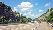
From here, the road continues north past suburban residential areas, with the northbound direction narrowing to 2 local lanes, before entering Bedminster Township
. Here, I-287 intersects I-78
at the Vincent R. Kramer Interchange, where the local-express lane configuration ends. Access from eastbound I-78 to southbound I-287 is only to the local lanes. Meanwhile, the express lanes of northbound I-287 provides access to westbound I-78 while the local lanes provide access to eastbound I-78. Following I-78, I-287 heads north with four northbound lanes and three southbound lanes into more wooded surroundings, reaching another interchange with US 202/US 206. At this point, the freeway median widens again as it turns northeast before continuing more to the east and entering Far Hills
. Within Far Hills, the road passes under CR 512
before the northbound direction narrows to three lanes and the wide median ends. Entering Bernards Township
, I-287 runs east-northeast to an interchange with CR 525
. After the CR 525 interchange, the road gains a wide median that narrows again before the road runs under New Jersey Transit's Gladstone Branch
, heading more to the northeast. Before leaving Bernards Township, there is an exit for North Maple Avenue.
, Morris County
at the crossing of the Passaic River
, where it becomes the Marine Hector Cafferata Jr. Cong. Medal of Honor Highway. It continues northeast, with US 202 running a short distance to the west. The freeway makes a turn more to the east as it comes to a truck-only rest area
in the northbound direction. The road crosses into Morris Township
, where it reaches an exit-only interchange with Harter Road; there are no entrances present. Shortly after Harter Road, there is a junction with CR 663 (James Street) that only has entrances to I-287. After this, I-287 turns north and enters Morristown
, where the northbound direction gains a fourth lane as the median narrows. The freeway enters more developed areas as it comes to the Route 124 interchange. From this point, the road becomes eight lanes total, with four in each direction, as it passes west of Morristown Memorial Hospital. After crossing under New Jersey Transit's Morristown Line
, it reaches the exit for CR 510
. From CR 510, I-287 makes a turn to the northeast, crossing back into Morris Township before continuing into Hanover Township
. Here, the route comes to the western terminus of the Route 24 freeway. Following Route 24, the freeway intersects Route 10. I-287 passes near several business parks as it enters Parsippany-Troy Hills
. In this area, there is an interchange with CR 511
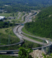
east of Lake Parsippany that also has access to Entin Road in the southbound direction. After this, I-287 widens to ten lanes with five northbound lanes, two express southbound lanes, and three local southbound lanes as it comes to the I-80
junction.
Following this interchange, the freeway becomes six lanes, with three in each direction as it continues into more wooded areas and reaching an exit with access to US 46
and US 202/CR 511. In this area, the highway runs to the west of the Jersey City Reservoir and immediately to the east of US 202/CR 511. I-287 comes to the Intervale Road exit, which carries US 202 and CR 511. The freeway enters Boonton
, where it turns northeast, with New Jersey Transit's Montclair-Boonton Line
located a short distance to the northwest. In Boonton, there is another interchange with US 202/CR 511. From here, I-287 curves more to the east, with US 202 running immediately to the north of the road. Along this stretch, there is an exit for US 202 and Vreeland Avenue. Upon entering Montville, the freeway draws away from US 202 as it passes near wooded residential areas before coming to another interchange with US 202. I-287 continues northeast from this point, crossing under New Jersey Transit's Montclair-Boonton Line before running north-northeast through more woodland as the terrain starts to get more mountainous. The freeway runs through Kinnelon
, where the northbound direction has four lanes, and Pequannock Township
before entering Riverdale
. In Riverdale, there is an interchange with Route 23. A short distance later, I-287 reaches the CR 694 interchange which provides access to CR 511 Alternate.
 Immediately after this, I-287 crosses the Pequannock River
into Bloomingdale, Passaic County
, where the highway becomes US Air Force Gunner Clarence "Red" Mosley Highway. The road continues northeast and turns north as it briefly passes through Pompton Lakes
before crossing into Wanaque
. Here, the road makes a turn northeast again as it comes to the CR 511 Alternate interchange. After this, I-287 passes through rock cuts in the Ramapo Mountains
before making a sharp turn east as it crosses high above the Wanaque River
valley on a bridge. The freeway continues into Oakland
, Bergen County
, where the name becomes Army Staff Sergeant Walter Bray Highway.
Here, there are a couple of businesses near the road before the interchange with Skyline Drive
. Following this, the road crosses the Ramapo River
before passing near neighborhoods and reaching a junction with US 202. After US 202, I-287 turns southeast and closely parallels the New York, Susquehanna and Western Railway
line to the southwest before entering Franklin Lakes
and coming to an interchange with the northern terminus of Route 208. Past this interchange, I-287 narrows to four lanes and turns northeast as the railroad line draws away. The freeway passes wooded residential neighborhoods prior to turning north and entering Mahwah Township
, where it continues near more wooded suburban areas as well as the Campgaw Mountain Reservation
to the west of the road. After passing to the east of the Ramapo College of New Jersey campus, I-287 passes over US 202. The freeway crosses the Ramapo River again before reaching an interchange with Route 17. At this point, Route 17 forms a concurrency
with I-287 and the road widens to six lanes as it passes between the Ramapo Mountain Reservation
to the west and business parks to the east.
 Upon entering New York in the Village of Suffern
in the Town of Ramapo
in Rockland County, New York
, New Jersey's Route 17 ends and NY 17
follows I-287 as the road comes to an interchange with the New York State Thruway
(I-87
). At this point, I-287 joins I-87 on the eight-lane New York State Thruway, passing over Metro-North Railroad
's Port Jervis Line as it heads east out of the mountains into suburban residential and commercial surroundings as it narrows to six lanes. After passing through the Village of Montebello
, the freeway reaches an interchange with Airmont Road where it becomes the border between Montebello to the north and the Village of Airmont
to the south. Continuing to the east, the New York State Thruway becomes the border between Monsey
and Airmont before separating Monsey from the Village of Chestnut Ridge
to the south as it turns slightly to the east-southeast. After briefly running along the south edge of the Village of Spring Valley
, where there is a westbound toll plaza for trucks, the highway fully enters Chestnut Ridge. In this area, it comes to the New York extension of the Garden State Parkway
. Following this junction, I-87/I-287 continues east into the Town of Clarkstown
, coming to an exit for NY 59
. After this, the road passes to the north of Nanuet
, crossing under New Jersey Transit/Metro-North Railroad's Pascack Valley Line
. The freeway crosses under NY 304
before the cloverleaf interchange with the Palisades Interstate Parkway
. As the Thruway continues into West Nyack
, it comes to the exit for NY 303
that provides access to the Palisades Center
shopping mall to the south of the road.
Past NY 303, I-87/I-287 turns to the east-southeast and passes near wooded areas as well as suburban neighborhoods of Central Nyack. It comes to another interchange with NY 59 that also provides access to US 9W
. At this point, the New York State Thruway widens to eight lanes and turns to the south-southeast into the Village of Nyack
in the Town of Orangetown
, crossing over US 9W prior to passing near residential areas in the Village of South Nyack
as it runs to the east of US 9W, descending The Palisades. The last interchange in Rockland County is with US 9W and has no southbound exit. From here, the New York State Thruway crosses the Hudson River
on the Tappan Zee Bridge
east into the Village of Tarrytown
in the Town of Greenburgh
in Westchester County
. After passing over the river, the road crosses over Metro-North Railroad's Hudson Line
before coming to an eastbound toll plaza. After this, the freeway comes to the exit for US 9 that also serves the western terminus of NY 119
. I-87/I-287 continue east past woodland and business parks, leaving Tarrytown before coming to an interchange where the two routes split, with I-87 continuing south on the New York State Thruway and I-287 heading east on the Cross-Westchester Expressway. This interchange also has access to and from the northbound Saw Mill River Parkway
and NY 119.
 The Cross-Westchester Expressway, which is maintained by the New York State Thruway Authority, is six lanes wide and carries I-287 east to a westbound exit for NY 119 that is intertwined with the ramps between the New York State Thruway and NY 119/Saw Mill River Parkway. After passing over the Saw Mill River Parkway and the Saw Mill River
, the road enters the Village of Elmsford
and runs through developed areas as it has a partial diamond interchange with NY 9A
that does not have an eastbound exit. The Cross-Westchester Expressway turns southeast from this point and intersects the Sprain Brook Parkway
. I-287 widens to eight lanes at this junction and continues to the exit for NY 100A
. After the NY 100A interchange, the freeway leaves Elmsford and turns to the east near residential areas, narrowing to six lanes before coming to an exit only for NY 100
and NY 119 that also has access to the Bronx River Parkway
.
Following this exit, the road becomes eight lanes again and crosses over the Bronx River Parkway, the Bronx River
, and Metro-North Railroad's Harlem Line. Here, the road crosses into White Plains
and reaches an interchange with NY 22
. Past NY 22, I-287 makes a sharp curve to the south as it narrows to six lanes and runs near inhabited neighborhoods. The road has a westbound exit and eastbound entrance with the Central Westchester Parkway
, a road that provides access to the Taconic State Parkway
by way of NY 22. The freeway runs past commercial areas to the east of downtown White Plains as it encounters Westchester Avenue, which connects to NY 119, NY 127
, and Anderson Hill Road as well as The Westchester
shopping mall in the downtown area. Within this interchange, the Cross-Westchester Expressway turns east along the border between Harrison
to the north and White Plains to the south. Westchester Avenue becomes a frontage road
for I-287 as the road passes corporate parks to the north and populated neighborhoods to the south.
The road begins to turn southeast as it comes to a directional interchange with the southern terminus of I-684
. The I-287 freeway heads south along the White Plains/Harrison border before turning east and fully entering Harrison, where there is a cloverleaf interchange with the Hutchinson River Parkway
. At this interchange, the Westchester Avenue frontage road serves as a collector/distributor road. The Cross-Westchester Expressway turns southeast again past wooded areas of development, with NY 120
coming onto the Westchester Avenue frontage road. I-287 reaches an interchange where the frontage road ends as Westchester Avenue heads east as NY 120A
and NY 120 continues to the south. Here, the freeway enters the Village of Rye Brook
in the Town of Rye as it continues southeast. The Cross-Westchester Expressway comes into the Village of Port Chester
, where the road runs near more dense suburban development as it intersects US 1
. At this point, the road has ramp access to and from the southbound direction of the New England Thruway
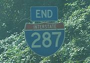
(I-95
). From here, the mainline I-287 narrows to four lanes and enters the City of Rye, where it passes over the Northeast Corridor before merging into northbound I-95 about 500 yards (meters) west of the Connecticut
state line. Legally, the New York section of I-287 is defined as Interstate Route Connections 520 and 525 in New York Highway Law § 340-a.
. The proposed beltway in New Jersey was designated as FAI Corridor 104 and later received the I-287 designation in 1958. The southern segment of I-287 was planned in the 1950s as the Middlesex Freeway, which was to run from the Outerbridge Crossing
to Staten Island and follow the Route 440 corridor to Edison, where it would connect to the New Jersey Turnpike before continuing west to I-78. From here, the freeway would parallel US 202 north to the New York border. The anticipated cost of building I-287 in New Jersey was $235 million. The southernmost part of I-287 in Middlesex County was to be cosigned with I-95; this never happened due to the cancellation of the Somerset Freeway. By the mid 1960s, I-287 had been completed between the New Jersey Turnpike and Bedminster Township and from US 46 in Parsippany to US 202 in Montville. More of I-287 in New Jersey had been finished by 1969, with from US 46 south to Route 10 in Hanover Township and from Bedminster Township north to Maple Avenue in Bernards Township opened. The segment of the highway between Maple Avenue and Route 10 opened in 1973, making I-287 a continuous road between the New Jersey Turnpike in Edison and US 202 in Montville.
 I-287's missing section between US 202 in Montville and the New York State Thruway in Suffern, NY was controversial dating back to 1965 and continuing until its opening in 1993. Property owners along the proposed route fought its completion as part of the freeway revolts
of the 1960s and 1970s. Originally, I-287 was proposed to take a more eastern route through the Lincoln Park
and Wayne
areas; this routing gained opposition as it passed through populated areas. A more western alignment was planned through mountainous areas in 1973, but this was rejected as the cost of building the road through the mountains was too high. In 1977, the current alignment of I-287 was proposed between Montville and Suffern; this was approved by the federal government in 1982 as it was less costly than the western alignment and went through less developed areas than the eastern alignment.
Permits allowing construction to begin on this segment were issued in 1988 by the Army Corps of Engineers. Officials in Rockland County, New York filed a lawsuit on November 19, 1993, hours before the highway's official ribbon-cutting, seeking to block its opening. They claimed the incomplete interchange with the New York State Thruway was inadequate to handle the additional traffic. That interchange was not complete until 1994, but the highway opened as planned on November 19 in a ceremony held on the Wanaque River bridge, where New Jersey Governor Jim Florio cut the ribbon. This moment marked the completion of a bypass around New York City that had been planned for decades. The portion of I-287 between the US 202 interchange in Oakland and the Route 208 interchange in Franklin Lakes overtook the westernmost portion of Route 208, truncating that route to its current location.
The completion of I-287 in New Jersey had significant effects on traffic and development patterns in the area. Several towns along the highway, such as Wanaque and Montville, saw increases in development. In addition, as the road was a bypass, it saw a significant increase in truck traffic wishing to bypass congested roads closer to New York City. The road also increased truck traffic on other north–south corridors, such as Route 31, from truckers wanting to bypass the New Jersey Turnpike by using these surface roads to get between the I-287 bypass of New York City and I-95 south to Pennsylvania
. On July 16, 1999, Governor Christine Todd Whitman
banned oversize trucks from using roads that are not part of the National Highway System
, such as Route 31. Trucks were therefore forced to use I-287 and the New Jersey Turnpike to travel across the state. In the 1990s, high-occupancy vehicle lane
s were built along I-287 between Bedminster and Parsippany. These HOV lanes, along with the ones that had been built on I-80, were opened to regular traffic in 1998 due to lack of usage, and the state did not have to repay the federal government the $240 million to build the lanes. In 2011, a small section of the northbound side of the highway in Boonton
collapsed into the Rockaway River
due to Hurricane Irene
.
 The New York State Thruway portion of I-287 was planned around 1950 as part of a tolled limited-access highway that was to connect the major cities of New York. A bridge across the Hudson River was planned between Nyack and Tarrytown at a site that was close enough to New York City
but far enough from the Port Authority of New York and New Jersey
's jurisdiction area, as they opposed the crossing. The portion of the thruway currently followed by I-287, including the Tappan Zee Bridge over the Hudson River, opened on December 15, 1955. In the 1960s, I-287 was designated along the New York State Thruway between Suffern and Tarrytown, while I-87 ran farther to the east on present-day I-684. On January 1, 1970, the I-87 designation was shifted onto this portion of the New York State Thruway to run concurrent with I-287.
The E-ZPass
electronic toll collection system was first introduced on this segment of the Thruway at the Spring Valley and Tappan Zee Bridge toll plazas in 1993. The same year, an interchange in Suffern opened providing access to the newly-opened New Jersey portion of I-287. In 1997, tolls for cars were eliminated at the Spring Valley toll plaza, with tolls remaining for trucks and other commercial vehicles. The I-87/I-287 interchange split near Tarrytown began a $187 million reconstruction in 2001 in order to add additional lanes and rebuild overpasses and underpasses. Reconstruction in this area was completed in May 2004.
traffic increases. When the Tappan Zee Bridge was proposed around 1950, the Cross-Westchester Expressway was becoming a more realistic idea. Construction of the freeway began in 1956, and was given the NY 119 designation. The design of the highway met Interstate highway standards
after opening, and was supposed to have the I-187 designation. However, by the time the highway opened, it was officially designated as I-487 instead. At a cost of $50 million, the Cross Westchester Expressway was opened December 1960. Later in the 1960s, this segment of road was redesignated I-287 to make it a part of the beltway around New York City.
I-287 was to continue past I-95 in Port Chester and was to cross Long Island Sound
via the unbuilt Oyster Bay-Rye Bridge. On Long Island
, the route would run along the Seaford – Oyster Bay Expressway (NY 135
). Then, I-287 was again to be extended into Jones Beach
by merging with the Wantagh State Parkway
in Merrick
. The plans for the bridge, and the I-287 extension onto Long Island, were dropped in 1973 by Governor Nelson Rockefeller
as a result of community opposition and environmental concerns.
Ownership of the Cross-Westchester Expressway was transferred from the New York State Department of Transportation
to the New York State Thruway Authority in 1990 to help relieve the state's budget issues. On July 27, 1994, a propane truck crashed into an overpass on the Cross-Westchester Expressway in White Plains and exploded, killing the driver. The fire from the explosion spread into adjacent neighborhoods and injured 23 people. In the mid 1990s, a reversible high-occupancy vehicle lane was proposed for the Cross-Westchester Expressway in order to alleviate congestion at a planned cost of $365 million. In addition, a Metro-North Railroad line and a guided busway were considered to serve the I-287 corridor in Westchester County as alternatives to the HOV lane. The proposed HOV lane was cancelled in 1997 by Governor George Pataki
out of the fear it would have negative effects on the area in trying to solve traffic. Since 1999, the Cross-Westchester Expressway has been under construction in order to improve congestion and safety for the motorists who use the highway. The final phase of the project, a reconstruction in the area of exit 8 in White Plains, is not expected to begin until 2010 with completion planned for 2012.
system that would link the western shore of the Hudson River with Westchester County and New York City. In addition, several alternatives are being considered for traffic management on the bridge, including high-occupancy toll lanes, park and ride
lots, ramp meter
s, and congestion tolling at peak times. Several designs for the new bridge, which is to be north of the existing structure, included suspension
, cantilever
, and cable-stayed
spans. In 2008, it was announced the state was going to replace the bridge in a $16 billion project that is to begin in 2012 with construction lasting four to five years.
, is to cost $29 million and is expected to be finished later in 2011.
across the Long Island Sound between Rye and Oyster Bay. This proposed tunnel would be the longest highway tunnel in the world, exceeding the Lærdalstunnelen
in Norway
by a mile. It would start at the junction with the Cross Westchester Expressway and the New England Thruway in Rye and end at NY 135 and NY 25
in Syosset
. Estimated to cost approximately $10 billion, it would feature three tubes: the outer tubes would have three lanes of vehicular traffic each and the inner tube would be used for maintenance. The proposed tunnel, which is to be operated by a private firm, is still awaiting approvals to begin construction.
!County
!Location
!Mile
!Exit
!Destinations
!Notes
|-
|rowspan=12|Middlesex
|rowspan=5|Edison Township
|rowspan=2|0.00
|
|, Staten Island
|Continuation beyond I-95 / NJ Turnpike
|-
|
|
|NJTP Exit 10
|-
|0.93
|1A-B
|
|CR 531 south is accessible from southbound traffic only
|-
|2.24
|2A-B
|
|Northbound exit and southbound entrance
|-
|3.09
|3
|
|Southbound exit and northbound entrance
|-
|South Plainfield Boro
|4.62
|4
|Durham Avenue – South Plainfield
|Northbound exit and southbound entrance
|-
|South Plainfield Boro
/Piscataway Township
|5.88
|5
|
|
|-
|rowspan=5|Piscataway Township
|6.41
|6
|Washington Avenue – Piscataway, Dunellen
|No southbound entrance
|-
|7.27
|7
|South Randolphville Road – Piscataway, Middlesex
|
|-
|rowspan=2|8.47
|rowspan=2|8
|Possumtown Road – Middlesex
, Highland Park
|Northbound exit and entrance
|-
|Centennial Avenue – Middlesex
, Highland Park
|Southbound exit and entrance
|-
|9.95
|9
|
|
|-
|rowspan=11|Somerset
|rowspan=2|Franklin Township
|10.27
|10
|
|
|-
|12.30
|12
|
|
|-
|rowspan=4|Bridgewater Township
|13.50
|13
|
|Split into 13A-B northbound
|-
|14.24
|14A
|
|No northbound entrance
|-
|14.35
|14B
|
|No southbound exit
|-
|17.86
|17
|
|Southbound exit and northbound entrance
|-
|rowspan=2|Bedminster Township
|21.17
|21A-B
|
|
|-
|22.21
|22A-B
|
|
|-
|rowspan=3|Bernards Township
|26.48
|26A-B
|
|
|-
|rowspan=2|29.94
|30A
|North Maple Avenue – Basking Ridge
|
|-
|30B
|
|
|-
|rowspan=14|Morris
|Morris Township
|34.02
|33
|Harter Road – Jockey Hollow
|
|-
|rowspan=2|Town of Morristown
|35.77
35.89
|35
|
|
|-
|36.39
36.60
|36
|
|Split into 36A-B northbound
|-
|rowspan=2|Hanover Township
|37.92
38.00
|37
|
|
|-
|39.55
|39
|
|
|-
|rowspan=4|Parsippany-Troy Hills Township
|40.94
|40
|
|
|-
|42.02
|41
|
|
|-
|42.74
|42
|
|
|-
|44.06
|43
|Intervale Road – Mountain Lakes
|
|-
|rowspan=2|Town of Boonton
|44.95
|44
|Main Street – Boonton
|
|-
|45.68
|45
|Myrtle Avenue / Wootton Street – Boonton
|
|-
|Montville Township
|47.11
|47
|
|
|-
|rowspan=2|Boro of Riverdale
|53.14
|52
|
|
|-
|53.83
|53
|
|
|-
|Passaic
|Boro of Wanaque
|55.31
|55
|
|
|-
|rowspan=5|Bergen
|rowspan=2|Boro of Oakland
|58.13
|57
|Skyline Drive
/ West Oakland Avenue – Ringwood
|
|-
|58.86
|58
|
|
|-
|Boro of Oakland
/Boro of Franklin Lakes
|59.94
|59
|
|
|-
|rowspan=2|Mahwah Township
|66.94
|66
|
|South end of NJ 17 overlap
|-
|rowspan=2|67.54
0.00
|rowspan=2 colspan=3 align="center"|New Jersey
– New York
state line; Route 17 becomes NY 17
|-
|rowspan=11|Rockland
|rowspan=5|Ramapo
|-
|0.11–0.65
|15
|
|North end of NY 17 overlap, west end of I-87 / Thruway overlap
|-
|3.47
|14B
|
|
|-
|6.78
|colspan=3 align="center"|Spring Valley
toll barrier (commercial vehicles only)
|-
|7.56
|14A
|
|
|-
|rowspan=3|Clarkstown
|8.29
|14
|
|
|-
|10.15
|13
|
|Signed as exits 13N (north) and 13S (south)
|-
|12.33
|12
|
|
|-
|Nyack
|13.49
|11
|
|
|-
|rowspan=2|South Nyack
|14.34
|10
|
|No southbound exit
|-
|colspan=4 rowspan=2 align="center"|Tappan Zee Bridge
over the Hudson River
|-
|rowspan=20|Westchester
|rowspan=3|Tarrytown
|-
|18.02
|colspan=3 align="center"|Tappan Zee Bridge toll barrier
|-
|18.24
|9
| - Tarrytown
, Sleepy Hollow
|
|-
|Greenburgh
|19.78
|8
|
|East end of I-87 / Thruway overlap
|-
|rowspan=4|Elmsford
|20.55
|1
|
|Eastbound exit is signed as exit 8A of I-87 / Thruway; access to Saw Mill Parkway
north via NY 119 east
|-
|21.23
|2
|
|No eastbound exit
|-
|
|3
|
|No access to Sprain Brook Parkway north from I-287 east
|-
|22.20
|4
|
|
|-
|Greenburgh
|23.01
|5
|
|Access to Bronx River Parkway
; NY 119 is accessed via NY 100 from westbound I-287
|-
|rowspan=2|White Plains
|24.10
|6
|
|Access to Bronx River Parkway
|-
|
|7
|Central Westchester Parkway
– Valhalla
|Westbound exit and eastbound entrance
|-
|rowspan=2|White Plains
– Harrison
line
|25.43
|8W-E
|Bloomingdale Road / Westchester Mall Place / To / Westchester Avenue
|Single exit 8 from westbound; NY 127 not signed westbound
|-
|26.69
|9A
| / Westchester Avenue – Brewster
|No access to Westchester Avenue from westbound
|-
|rowspan=3|Harrison
|27.87
|9S-N
|
|Westchester Avenue acts as a collector/distributor road
|-
|rowspan=2|28.57
|rowspan=2|10
|
|
|-
|Bowman Avenue / Webb Avenue
|
|-
|Rye
– Port Chester
line
|30.67
|11
|
|Eastbound exit and westbound entrance
|-
|rowspan=3|Rye
|rowspan=3|31.11
|12
|
|
|-
|
|Midland Avenue - Port Chester
, Rye
|Westbound exit and entrance
|-
|
|
|Eastbound exit and westbound entrance
U.S. state
A U.S. state is any one of the 50 federated states of the United States of America that share sovereignty with the federal government. Because of this shared sovereignty, an American is a citizen both of the federal entity and of his or her state of domicile. Four states use the official title of...
s of New Jersey
New Jersey
New Jersey is a state in the Northeastern and Middle Atlantic regions of the United States. , its population was 8,791,894. It is bordered on the north and east by the state of New York, on the southeast and south by the Atlantic Ocean, on the west by Pennsylvania and on the southwest by Delaware...
and New York
New York
New York is a state in the Northeastern region of the United States. It is the nation's third most populous state. New York is bordered by New Jersey and Pennsylvania to the south, and by Connecticut, Massachusetts and Vermont to the east...
. It is a partial beltway around New York City
New York City
New York is the most populous city in the United States and the center of the New York Metropolitan Area, one of the most populous metropolitan areas in the world. New York exerts a significant impact upon global commerce, finance, media, art, fashion, research, technology, education, and...
, serving the northern half of New Jersey and the counties of Rockland
Rockland County, New York
Rockland County is a suburban county 15 miles to the northwest of Manhattan and part of the New York City Metropolitan Area, in the U.S. state of New York. It is the southernmost county in New York west of the Hudson River, and the smallest county in New York outside of New York City. The...
and Westchester
Westchester County, New York
Westchester County is a county located in the U.S. state of New York. Westchester covers an area of and has a population of 949,113 according to the 2010 Census, residing in 45 municipalities...
in New York. I-287, which is signed north–south in New Jersey and east–west in New York, follows a roughly horseshoe-shaped route from the New Jersey Turnpike
New Jersey Turnpike
The New Jersey Turnpike is a toll road in New Jersey, maintained by the New Jersey Turnpike Authority. According to the International Bridge, Tunnel and Turnpike Association, the Turnpike is the nation's sixth-busiest toll road and is among one of the most heavily traveled highways in the United...
(I-95
Interstate 95 in New Jersey
Interstate 95 is a major Interstate Highway that traverses the full extent of the East Coast of the United States, from Florida to Maine...
) in Edison Township, New Jersey
Edison, New Jersey
Edison Township is a township in Middlesex County, New Jersey. What is now Edison Township was originally incorporated as Raritan Township by an Act of the New Jersey Legislature on March 17, 1870, from portions of both Piscataway Township and Woodbridge Township...
clockwise to the New England Thruway
New England Thruway
The New England Thruway is a portion of the U.S. Interstate highway system and of the New York State Thruway, within and operated by the New York State Thruway Authority, linking New York City with New England, specifically with southwestern Connecticut...
(I-95
Interstate 95 in New York
Interstate 95 is a part of the Interstate Highway System that runs from Miami, Florida, to the Canada – United States border near Houlton, Maine. In the U.S. state of New York, I-95 extends from the George Washington Bridge in New York City to the Connecticut state line at Port Chester...
) in Rye, New York, for 98.72 miles (158.87 km). Through New Jersey, I-287 runs west from its southern terminus in Edison through suburban areas. In Bridgewater Township
Bridgewater Township, New Jersey
Bridgewater Township is a township in Somerset County, New Jersey, United States. , the township population was 44,464.Bridgewater Township was originally created by Royal Charter on April 4, 1749, from portions of the Northern precinct, and was incorporated as one of New Jersey's initial group of...
, the freeway takes a more northeasterly course, paralleled by US 202
U.S. Route 202 in New Jersey
U.S. Route 202 is a U.S. Highway running from New Castle, Delaware northeast to Bangor, Maine. In the U.S. state of New Jersey, the route runs from the New Hope-Lambertville Toll Bridge over the Delaware River at the Pennsylvania border in Delaware Township, Hunterdon County near Lambertville...
. The northernmost part of I-287 in New Jersey passes through mountainous surroundings. After crossing into New York at Suffern
Suffern, New York
Suffern is a village in the Town of Ramapo, Rockland County, New York, United States located north of the State of New Jersey; east of Hillburn; south of Montebello and west of Airmont...
, I-287 turns east on the New York State Thruway
New York State Thruway
The New York State Thruway is a system of limited-access highways located within the state of New York in the United States. The system, known officially as the Governor Thomas E. Dewey Thruway for former New York Governor Thomas E. Dewey, is operated by the New York State Thruway Authority and...
(I-87
Interstate 87
Interstate 87 is a Interstate Highway located entirely within New York State in the United States of America. I-87 is the longest intrastate Interstate highway in the Interstate Highway System. Its southern end is at the Bronx approaches of the Robert F. Kennedy Bridge in New York City...
) and runs though Rockland County. After crossing the Hudson River
Hudson River
The Hudson is a river that flows from north to south through eastern New York. The highest official source is at Lake Tear of the Clouds, on the slopes of Mount Marcy in the Adirondack Mountains. The river itself officially begins in Henderson Lake in Newcomb, New York...
on the Tappan Zee Bridge
Tappan Zee Bridge
The Governor Malcolm Wilson Tappan Zee Bridge, usually referred to as Tappan Zee Bridge, is a cantilever bridge in New York over the Hudson River at one of its widest points; the Tappan Zee is named for an American Indian tribe from the area called "Tappan"; and zee being the Dutch word for "sea"....
, I-287 splits from I-87 near Tarrytown
Tarrytown, New York
Tarrytown is a village in the town of Greenburgh in Westchester County, New York, United States. It is located on the eastern bank of the Hudson River, about north of midtown Manhattan in New York City, and is served by a stop on the Metro-North Hudson Line...
and continues east through Westchester County on the Cross-Westchester Expressway.
A bypass around New York City had been planned since the 1950s and would become a part of the Interstate Highway System and receive the I-287 designation. The Cross-Westchester Expressway, which was originally designated as Interstate 187, opened in 1960 as Interstate 487 before later becoming part of I-287. The New York State Thruway portion of I-287, which included a crossing of the Hudson River, opened in 1955. In New Jersey, the proposed I-287 had originally been designated as FAI Corridor 104 and incorporated what was planned as the Middlesex Freeway. The New Jersey section of I-287 between the New Jersey Turnpike in Edison and US 202 in Montville opened in stages between the 1960s and 1973; the remainder opened in 1994. A replacement of the aging Tappan Zee Bridge is planned, with construction to start in 2012. In addition, a proposed tunnel
Long Island Sound link
The Long Island Sound link is a proposed bridge or tunnel that would link Long Island to the south with New York or Connecticut to the north across Long Island Sound. The most recent proposal involves a tunnel between Rye, New York on the mainland and Oyster Bay on the island...
across the Long Island Sound
Long Island Sound
Long Island Sound is an estuary of the Atlantic Ocean, located in the United States between Connecticut to the north and Long Island, New York to the south. The mouth of the Connecticut River at Old Saybrook, Connecticut, empties into the sound. On its western end the sound is bounded by the Bronx...
between Rye and Oyster Bay on Long Island
Long Island
Long Island is an island located in the southeast part of the U.S. state of New York, just east of Manhattan. Stretching northeast into the Atlantic Ocean, Long Island contains four counties, two of which are boroughs of New York City , and two of which are mainly suburban...
would link the eastern terminus of I-287 to NY 25
New York State Route 25
New York State Route 25 is an east–west state highway in downstate New York in the United States. The route extends for just over from east midtown Manhattan in New York City to the Cross Sound Ferry terminal at Orient Point on the end of Long Island's North Fork...
and NY 135
New York State Route 135
New York State Route 135 is a state highway in eastern Nassau County, New York, United States. The route is a limited-access highway that connects Seaford with Syosset. The highway runs from Merrick Road in Seaford to NY 25 in Syosset...
in Syosset
Syosset, New York
Syosset is a hamlet in Nassau County, New York, in the northeastern section of Town of Oyster Bay near the North Shore of Long Island. The population was 18,829 at the 2010 census...
.
Route description
|-|NJ
New Jersey
New Jersey is a state in the Northeastern and Middle Atlantic regions of the United States. , its population was 8,791,894. It is bordered on the north and east by the state of New York, on the southeast and south by the Atlantic Ocean, on the west by Pennsylvania and on the southwest by Delaware...
|| 67.54 || 108.70
|-
|NY
New York
New York is a state in the Northeastern region of the United States. It is the nation's third most populous state. New York is bordered by New Jersey and Pennsylvania to the south, and by Connecticut, Massachusetts and Vermont to the east...
|| 31.18 || 50.18
|-
|Total || 98.72 || 158.87
|}
Middlesex County
I-287 begins at an interchange with the New Jersey TurnpikeNew Jersey Turnpike
The New Jersey Turnpike is a toll road in New Jersey, maintained by the New Jersey Turnpike Authority. According to the International Bridge, Tunnel and Turnpike Association, the Turnpike is the nation's sixth-busiest toll road and is among one of the most heavily traveled highways in the United...
(I-95
Interstate 95 in New Jersey
Interstate 95 is a major Interstate Highway that traverses the full extent of the East Coast of the United States, from Florida to Maine...
) in Edison
Edison, New Jersey
Edison Township is a township in Middlesex County, New Jersey. What is now Edison Township was originally incorporated as Raritan Township by an Act of the New Jersey Legislature on March 17, 1870, from portions of both Piscataway Township and Woodbridge Township...
in Middlesex County, New Jersey
Middlesex County, New Jersey
-Demographics:As of the census of 2000, there were 750,162 people, 265,815 households, and 190,855 families residing in the county. The population density was 2,422 people per square mile . There were 273,637 housing units at an average density of 884 per square mile...
, where the freeway continues east as Route 440 towards Perth Amboy
Perth Amboy, New Jersey
Perth Amboy is a city in Middlesex County, New Jersey, United States. The City of Perth Amboy is part of the New York metropolitan area. As of the 2010 United States Census, the city population was 50,814. Perth Amboy is known as the "City by the Bay", referring to Raritan Bay.-Name:The Lenape...
and Staten Island
Staten Island
Staten Island is a borough of New York City, New York, United States, located in the southwest part of the city. Staten Island is separated from New Jersey by the Arthur Kill and the Kill Van Kull, and from the rest of New York by New York Bay...
. Within Middlesex County, I-287 is called the Lt. Col. (Ret) Richard F. Lauer, US Army Highway. From this point, it heads west as an eight-lane freeway through suburban areas, soon reaching an interchange with US 1
U.S. Route 1 in New Jersey
U.S. Route 1 is a United States highway which parallels the East Coast of the United States, running from Key West, Florida in the south to Fort Kent, Maine at the Canadian border in the north. Of the entire length of the route, of it runs through New Jersey...
that also has access to CR 531
County Route 531 (New Jersey)
County Route 531 is a county highway in the U.S. state of New Jersey. The highway extends 13.61 miles from Woodbridge Avenue in Edison, Middlesex County, through Somerset County to Passaic Valley Road in Long Hill Township, Morris County.-Route description:Route 531 begins at CR 514 in Edison...
in the southbound direction. Past this point, the road turns more to the northwest as it comes to the junction with Route 27 (Lincoln Highway
Lincoln Highway
The Lincoln Highway was the first road across the United States of America.Conceived and promoted by entrepreneur Carl G. Fisher, the Lincoln Highway spanned coast-to-coast from Times Square in New York City to Lincoln Park in San Francisco, originally through 13 states: New York, New Jersey,...
). Following Route 27, I-287 narrows to six lanes and passes over Amtrak
Amtrak
The National Railroad Passenger Corporation, doing business as Amtrak , is a government-owned corporation that was organized on May 1, 1971, to provide intercity passenger train service in the United States. "Amtrak" is a portmanteau of the words "America" and "track". It is headquartered at Union...
's Northeast Corridor
Northeast Corridor
The Northeast Corridor is a fully electrified railway line owned primarily by Amtrak serving the Northeast megalopolis of the United States from Boston in the north, via New York to Washington, D.C. in the south, with branches serving other cities...
as it continues to a southbound exit and northbound entrance with CR 501
County Route 501 (New Jersey)
County Route 501 is a county highway in New Jersey in two sections spanning Middlesex, Hudson and Bergen Counties. The southern section runs from South Plainfield to Perth Amboy, the northern section runs from Bayonne to Rockleigh, and the two sections are connected by New York State Route 440...
.
As the freeway continues into South Plainfield
South Plainfield, New Jersey
South Plainfield is a Borough in Middlesex County, New Jersey, United States. As of the 2010 United States Census, the borough population was 23,385....
, it passes near several business parks and comes to a partial interchange with Durham Avenue which only has a northbound exit and southbound entrance At this point, the road starts to turn more west before it comes to a full junction with CR 529
County Route 529 (New Jersey)
County Route 529 is a county highway in the U.S. state of New Jersey. The highway extends from Woodbridge Avenue in Edison to Mountain Boulevard in Watchung.-Route description:...
. Here, the road enters Piscataway Township
Piscataway Township, New Jersey
The township consists of the following historic villages and areas: New Market, known as Quibbletown in the 18th Century, Randolphville, Fieldville and North Stelton...
and reaches an interchange with CR 665 (Washington Avenue). Continuing near more business parks, I-287 comes to the exit for South Randolphville Road. Following this interchange, the road heads west more before it turns to the southwest and comes to the Possumtown Road interchange. After Possumtown Road, the freeway comes to the CR 622
County Route 622 (Middlesex County, New Jersey)
Middlesex County Route 622 is a county highway in Middlesex County, New Jersey. It traverses the municipalities of Highland Park, Piscataway and Middlesex in its 7.44 mile length. The road began as Middlesex County Route 2R8 circa 1947. The road was changed into County Route 514 Spur, a spur...
(River Road) exit.
Somerset County
After crossing over the Raritan RiverRaritan River
The Raritan River is a major river of central New Jersey in the United States. Its watershed drains much of the mountainous area of the central part of the state, emptying into the Raritan Bay on the Atlantic Ocean.-Description:...
, I-287 enters Franklin Township
Franklin Township, Somerset County, New Jersey
-Communities of Franklin Township:The following are census-designated places, unincorporated enclaves, and historical communities located within Franklin Township...
, Somerset County
Somerset County, New Jersey
Somerset County is a county located in the U.S. state of New Jersey. In 2010, the population was 323,444. It is part of the New York Metropolitan Area. Its county seat is Somerville....
and becomes the Captain (Ret) Joseph Azzolina, US Navy Highway. Soon after the river, there is an interchange with CR 527
County Route 527 (New Jersey)
County Route 527 is a county highway in the U.S. state of New Jersey. The highway extends from Main Street in Toms River Township to Pompton Avenue in Cedar Grove. It is the second longest county highway in New Jersey after Route 519. It was first given the number 527 in 1954...
. After CR 527, the freeway makes a turn to the northwest and passes a mix of residential areas and business parks. The road has an interchange with CR 623 (Weston Canal Road) before crossing the Raritan River again and continuing into Bridgewater Township
Bridgewater Township, New Jersey
Bridgewater Township is a township in Somerset County, New Jersey, United States. , the township population was 44,464.Bridgewater Township was originally created by Royal Charter on April 4, 1749, from portions of the Northern precinct, and was incorporated as one of New Jersey's initial group of...
. Within Bridgewater Township, I-287 curves north-northwest and passes over both New Jersey Transit
New Jersey Transit
The New Jersey Transit Corporation is a statewide public transportation system serving the United States state of New Jersey, and New York, Orange, and Rockland counties in New York State...
's Raritan Valley Line
Raritan Valley Line
The Raritan Valley Line is a diesel-engine-powered commuter rail service operated by New Jersey Transit , originating out of Pennsylvania Station, located in Newark, New Jersey, with most trains terminating at the Raritan station, located in Raritan, New Jersey.Some weekday trains continue further...
and CR 533
County Route 533 (New Jersey)
County Route 533 is a county highway in the U.S. state of New Jersey. The highway extends from the White Horse Circle, in Hamilton Township to County Route 527 in Bound Brook. Route 533 shares a major concurrency with U.S...
near TD Bank Ballpark, which is home to the Somerset Patriots
Somerset Patriots
The Somerset Patriots are an American professional baseball team based in Bridgewater Township, New Jersey. They are a member of the Freedom Division of the Atlantic League of Professional Baseball, which is not affiliated with Major League Baseball...
baseball team. Past this area, the road encounters Route 28 at an interchange. Past Route 28, the freeway turns northwest and intersects US 22
U.S. Route 22 in New Jersey
U.S. Route 22 is a U.S. highway stretching from Cincinnati, Ohio in the west to Newark, New Jersey in the east. In New Jersey, the route runs for from the Easton-Phillipsburg Toll Bridge over the Delaware River in Phillipsburg, Warren County to Interstate 78 , US 1/9, and Route 21 at the Newark...
at a partial interchange with a northbound exit and entrance and southbound entrance. From this point, I-287 makes a turn to the west and runs to the north of US 22 as it has a wide median. The freeway turns northwest as it passes near the Bridgewater Commons
Bridgewater Commons
Bridgewater Commons is a fully enclosed mall located in Bridgewater Township, New Jersey. The mall is located at the intersection of U.S. Route 22 and U.S. Route 202/U.S. Route 206 and borders Interstate 287. The mall opened in 1989 and has a gross leasable area of...
shopping mall and reaches a partial interchange with US 202
U.S. Route 202 in New Jersey
U.S. Route 202 is a U.S. Highway running from New Castle, Delaware northeast to Bangor, Maine. In the U.S. state of New Jersey, the route runs from the New Hope-Lambertville Toll Bridge over the Delaware River at the Pennsylvania border in Delaware Township, Hunterdon County near Lambertville...
/US 206
U.S. Route 206
U.S. Route 206 is a long north–south United States highway in New Jersey and Pennsylvania, United States. Only about a half a mile of its length is in Pennsylvania; the Milford-Montague Toll Bridge carries it over the Delaware River into New Jersey, where it is the remainder of the route...
. Through the remainder of New Jersey, US 202 will parallel the course of I-287. At this point, I-287 gains a local-express lane
Local-express lanes
A Local-express lane system is an arrangement of roadways within a major highway providing one of more roadways for express lanes with a limited number of entrances and exits and also separate roadways for local or collector lanes which provide access to all interchanges...
configuration, with 3 local and 2 express lanes southbound and 3 express and 3 local lanes northbound. Both the southbound local and express lanes have access to southbound US 202/US 206 at this interchange, whereas northbound US 202/US 206 only has access to the local lanes of northbound I-287.
From here, the road continues north past suburban residential areas, with the northbound direction narrowing to 2 local lanes, before entering Bedminster Township
Bedminster Township, New Jersey
Bedminster Township is a Township in Somerset County, New Jersey, United States. As of the 2010 United States Census, the township population was 8,165....
. Here, I-287 intersects I-78
Interstate 78 in New Jersey
Interstate 78 is an east–west route stretching from Union Township, Lebanon County, Pennsylvania to New York City. In New Jersey, I-78 is called the Phillipsburg–Newark Expressway and the Newark Bay Extension of the New Jersey Turnpike...
at the Vincent R. Kramer Interchange, where the local-express lane configuration ends. Access from eastbound I-78 to southbound I-287 is only to the local lanes. Meanwhile, the express lanes of northbound I-287 provides access to westbound I-78 while the local lanes provide access to eastbound I-78. Following I-78, I-287 heads north with four northbound lanes and three southbound lanes into more wooded surroundings, reaching another interchange with US 202/US 206. At this point, the freeway median widens again as it turns northeast before continuing more to the east and entering Far Hills
Far Hills, New Jersey
Far Hills is a borough in Somerset County, New Jersey, United States. As of the United States 2010 Census, the population was 919.Far Hills was incorporated as a borough based on an Act of the New Jersey Legislature passed on April 7, 1921, from portions of Bernards Township, subject to the results...
. Within Far Hills, the road passes under CR 512
County Route 512 (New Jersey)
County Route 512 is a county highway in the U.S. state of New Jersey. The highway extends from High Bridge Road in Califon to Springfield Avenue / Route 24 in Summit.-Hunterdon County:...
before the northbound direction narrows to three lanes and the wide median ends. Entering Bernards Township
Bernards Township, New Jersey
-History:Bernards Township was originally formed by Royal Charter in 1760 as Bernardston Township from remaining portions of Northern precinct. It was incorporated as Bernards Township as one of New Jersey's initial group of 104 townships by an Act of the New Jersey Legislature on February 21, 1798...
, I-287 runs east-northeast to an interchange with CR 525
County Route 525 (New Jersey)
County Route 525 is a county highway in the U.S. state of New Jersey. The highway extends from Union Avenue in Bound Brook to Main Street in Mendham Borough....
. After the CR 525 interchange, the road gains a wide median that narrows again before the road runs under New Jersey Transit's Gladstone Branch
Gladstone Branch
The Gladstone Branch is a branch of New Jersey Transit's Morris and Essex Lines. The Gladstone Branch primarily serves commuter trains; freight service is no longer operated...
, heading more to the northeast. Before leaving Bernards Township, there is an exit for North Maple Avenue.
Morris County
A short distance after this interchange, I-287 enters Harding TownshipHarding Township, New Jersey
- Demographics :As of the census of 2000, there were 3,180 people, 1,180 households, and 940 families residing in the township. The population density was 155.6 people per square mile . There were 1,243 housing units at an average density of 60.8 per square mile...
, Morris County
Morris County, New Jersey
Morris County is a county located in the U.S. state of New Jersey, about west of New York City. According to the United States 2010 Census, the population was 492,276. It is part of the New York Metropolitan Area. Its county seat is Morristown....
at the crossing of the Passaic River
Passaic River
The Passaic River is a mature surface river, approximately 80 mi long, in northern New Jersey in the United States. The river in its upper course flows in a highly circuitous route, meandering through the swamp lowlands between the ridge hills of rural and suburban northern New Jersey,...
, where it becomes the Marine Hector Cafferata Jr. Cong. Medal of Honor Highway. It continues northeast, with US 202 running a short distance to the west. The freeway makes a turn more to the east as it comes to a truck-only rest area
Rest area
A rest area, travel plaza, rest stop, or service area is a public facility, located next to a large thoroughfare such as a highway, expressway, or freeway at which drivers and passengers can rest, eat, or refuel without exiting on to secondary roads...
in the northbound direction. The road crosses into Morris Township
Morris Township, New Jersey
Morris Township is a township in Morris County, New Jersey, USA. As of the United States 2000 Census, the township population was 21,796. It is known as the "doughnut" around Morristown since it completely encapsulates it, and has at least five times the area...
, where it reaches an exit-only interchange with Harter Road; there are no entrances present. Shortly after Harter Road, there is a junction with CR 663 (James Street) that only has entrances to I-287. After this, I-287 turns north and enters Morristown
Morristown, New Jersey
Morristown is a town in Morris County, New Jersey, United States. As of the 2010 United States Census, the town population was 18,411. It is the county seat of Morris County. Morristown became characterized as "the military capital of the American Revolution" because of its strategic role in the...
, where the northbound direction gains a fourth lane as the median narrows. The freeway enters more developed areas as it comes to the Route 124 interchange. From this point, the road becomes eight lanes total, with four in each direction, as it passes west of Morristown Memorial Hospital. After crossing under New Jersey Transit's Morristown Line
Morristown Line
The Morristown Line is one of New Jersey Transit's commuter lines and is one of two branches that run along the Morris and Essex Lines. Out of 60 inbound and 58 outbound daily weekday trains, 28 inbound and 26 outbound trains use the Kearny Connection to Secaucus Junction and New York Penn...
, it reaches the exit for CR 510
County Route 510 (New Jersey)
County Route 510 is a county highway in the U.S. state of New Jersey. The highway extends from North Road in Chester to McCarter Highway in Newark.A separate, westbound portion of CR 510 stretches through Morristown.-Morris County:...
. From CR 510, I-287 makes a turn to the northeast, crossing back into Morris Township before continuing into Hanover Township
Hanover Township, New Jersey
Hanover Township is a Township in Morris County, New Jersey, United States. At the 2000 United States Census, the township population was 12,898...
. Here, the route comes to the western terminus of the Route 24 freeway. Following Route 24, the freeway intersects Route 10. I-287 passes near several business parks as it enters Parsippany-Troy Hills
Parsippany-Troy Hills, New Jersey
Parsippany-Troy Hills Township, commonly called Parsippany, is a township in Morris County, New Jersey, United States. As of the 2000 United States Census, the township population was 50,649. The name Parsippany comes from the Lenape Native American word parsipanong, which means "the place where...
. In this area, there is an interchange with CR 511
County Route 511 (New Jersey)
County Route 511 is a county highway in the U.S. state of New Jersey. The highway extends 37.44 miles from Columbia Avenue in Morris Township to the New York state line in West Milford....
east of Lake Parsippany that also has access to Entin Road in the southbound direction. After this, I-287 widens to ten lanes with five northbound lanes, two express southbound lanes, and three local southbound lanes as it comes to the I-80
Interstate 80 in New Jersey
Interstate 80 is a major Interstate Highway in the United States, running from the New York City Metropolitan Area westward to San Francisco, California...
junction.
Following this interchange, the freeway becomes six lanes, with three in each direction as it continues into more wooded areas and reaching an exit with access to US 46
U.S. Route 46
U.S. Route 46 is an east–west U.S. Highway, running for , completely within the state of New Jersey. The west end is at an interchange with Interstate 80 and Route 94 in Columbia, Warren County on the Delaware River...
and US 202/CR 511. In this area, the highway runs to the west of the Jersey City Reservoir and immediately to the east of US 202/CR 511. I-287 comes to the Intervale Road exit, which carries US 202 and CR 511. The freeway enters Boonton
Boonton, New Jersey
Boonton is a town in Morris County, New Jersey that was chartered in 1867. As of the 2010 United States Census, the town population was 8,347. The town was originally called "Boone-Towne" in 1761 in honor of the Colonial Governor Thomas Boone....
, where it turns northeast, with New Jersey Transit's Montclair-Boonton Line
Montclair-Boonton Line
The Montclair-Boonton Line is a commuter rail line of New Jersey Transit Rail Operations. It is part of the Hoboken Division. The line is a consolidation of three individual lines: the former Delaware, Lackawanna & Western Railroad's Montclair Branch, which ran from Hoboken Terminal to Bay Street,...
located a short distance to the northwest. In Boonton, there is another interchange with US 202/CR 511. From here, I-287 curves more to the east, with US 202 running immediately to the north of the road. Along this stretch, there is an exit for US 202 and Vreeland Avenue. Upon entering Montville, the freeway draws away from US 202 as it passes near wooded residential areas before coming to another interchange with US 202. I-287 continues northeast from this point, crossing under New Jersey Transit's Montclair-Boonton Line before running north-northeast through more woodland as the terrain starts to get more mountainous. The freeway runs through Kinnelon
Kinnelon, New Jersey
Kinnelon is a Borough in Morris County, New Jersey, United States. As of the 2010 United States Census, the borough population was 10,248. It is a low density, suburban community, with many parks and trails....
, where the northbound direction has four lanes, and Pequannock Township
Pequannock Township, New Jersey
Pequannock Township is a Township in Morris County, New Jersey, United States. As of the United States 2000 Census, the township population was 13,888....
before entering Riverdale
Riverdale, New Jersey
As of the census of 2000, there were 2,498 people, 919 households, and 671 families residing in the borough. The population density was 1,215.2 people per square mile . There were 940 housing units at an average density of 457.3 per square mile...
. In Riverdale, there is an interchange with Route 23. A short distance later, I-287 reaches the CR 694 interchange which provides access to CR 511 Alternate.
Passaic and Bergen counties
Pequannock River
The Pequannock River is a tributary of the Pompton River, approximately 20 miles long, located in northern New Jersey in the United States....
into Bloomingdale, Passaic County
Passaic County, New Jersey
Passaic County is a county located in the U.S. state of New Jersey. As of the 2010 Census, the population was 501,226. Its county seat is Paterson...
, where the highway becomes US Air Force Gunner Clarence "Red" Mosley Highway. The road continues northeast and turns north as it briefly passes through Pompton Lakes
Pompton Lakes, New Jersey
Pompton Lakes is a borough in Passaic County, New Jersey, United States. As of the 2010 United States Census, the borough population was 11,097....
before crossing into Wanaque
Wanaque, New Jersey
Wanaque is a borough in Passaic County, New Jersey, United States. As of the 2010 United States Census, the borough population was 11,116.Wanaque was incorporated as an independent Borough on February 23, 1918, when Pompton Township was split up into three Boroughs, along with Bloomingdale and...
. Here, the road makes a turn northeast again as it comes to the CR 511 Alternate interchange. After this, I-287 passes through rock cuts in the Ramapo Mountains
Ramapo Mountains
The Ramapo Mountains are a forested chain of the Appalachian mountains in northeastern New Jersey and southeastern New York in the United States...
before making a sharp turn east as it crosses high above the Wanaque River
Wanaque River
The Wanaque River is a tributary of the Pequannock River in Passaic County in northern New Jersey in the United States....
valley on a bridge. The freeway continues into Oakland
Oakland, New Jersey
Oakland is a borough in Bergen County, New Jersey, United States. As of the 2010 United States Census, the borough population was 12,754.Oakland was incorporated as a borough by an Act of the New Jersey Legislature on April 8, 1902, from portions of Franklin Township.-History:The Van Allen House...
, Bergen County
Bergen County, New Jersey
Bergen County is the most populous county of the state of New Jersey, United States. As of the 2010 United States Census, its population was 905,116. The county is part of the New York City Metropolitan Area. Its county seat is Hackensack...
, where the name becomes Army Staff Sergeant Walter Bray Highway.
Here, there are a couple of businesses near the road before the interchange with Skyline Drive
Skyline Drive (New Jersey)
Skyline Drive is a 5.76-mile long road in Northern New Jersey, between Interstate 287 in Oakland, Bergen County and County Route 511 in Ringwood, Passaic County, passing through Ringwood State Park in the Ramapo Mountains. It is a major route for those in the Ringwood and Wanaque area to get to...
. Following this, the road crosses the Ramapo River
Ramapo River
The Ramapo River is a tributary of the Pompton River, approximately 30 mi long, in southern New York and northern New Jersey in the United States.-Course:...
before passing near neighborhoods and reaching a junction with US 202. After US 202, I-287 turns southeast and closely parallels the New York, Susquehanna and Western Railway
New York, Susquehanna and Western Railway
The New York, Susquehanna and Western Railway , also known as the Susie-Q, or simply the Susquehanna, is a Class II American freight railway operating over 500 miles of track in the northeastern states of New York, Pennsylvania and New Jersey. It was formed in 1881 from the merger of several...
line to the southwest before entering Franklin Lakes
Franklin Lakes, New Jersey
Franklin Lakes is a borough in Bergen County, New Jersey, United States. As of the 2010 census, the borough population was 10,590. As of the 2000 Census, Franklin Lakes had the 18th-highest per-capita income of all 566 municipalities in the state. Nationwide, Franklin Lakes ranked 17th among the...
and coming to an interchange with the northern terminus of Route 208. Past this interchange, I-287 narrows to four lanes and turns northeast as the railroad line draws away. The freeway passes wooded residential neighborhoods prior to turning north and entering Mahwah Township
Mahwah, New Jersey
Mahwah is a township in Bergen County, New Jersey, United States. As of the 2010 United States Census, the township population was 25,890. The name Mahwah is derived from the Lenni Lenape word "mawewi" which means "Meeting Place" or "Place Where Paths Meet".The area that is now Mahwah was...
, where it continues near more wooded suburban areas as well as the Campgaw Mountain Reservation
Campgaw Mountain Reservation
Campgaw Mountain Reservation is a 1351 acre county park of Bergen County, New Jersey. It is located mostly within Mahwah, but includes some areas of Oakland and Franklin Lakes. The park includes a ski area and the peak of Campgaw Mountain at a elevation.The ski area has two 2-person chairlifts...
to the west of the road. After passing to the east of the Ramapo College of New Jersey campus, I-287 passes over US 202. The freeway crosses the Ramapo River again before reaching an interchange with Route 17. At this point, Route 17 forms a concurrency
Concurrency (road)
A concurrency, overlap, or coincidence in a road network is an instance of one physical road bearing two or more different highway, motorway, or other route numbers...
with I-287 and the road widens to six lanes as it passes between the Ramapo Mountain Reservation
Ramapo Mountain Reservation
The Ramapo Valley Reservation is a 3000+acre county park located in Mahwah, New Jersey in Bergen County, bordering Ringwood State Park to the north and the Ramapo Mountain State Forest to the south. It is also known as the Ramapo Reservation and the Ramapo Valley County Reservation...
to the west and business parks to the east.
New York State Thruway
Suffern, New York
Suffern is a village in the Town of Ramapo, Rockland County, New York, United States located north of the State of New Jersey; east of Hillburn; south of Montebello and west of Airmont...
in the Town of Ramapo
Ramapo, New York
Ramapo , formerly known as New Hempstead and then Hampstead, is a town in Rockland County, New York, United States located north of New Jersey; southeast of Orange County, New York; south of the Town of Haverstraw and west of the Town of Clarkstown and the Town of Orangetown...
in Rockland County, New York
Rockland County, New York
Rockland County is a suburban county 15 miles to the northwest of Manhattan and part of the New York City Metropolitan Area, in the U.S. state of New York. It is the southernmost county in New York west of the Hudson River, and the smallest county in New York outside of New York City. The...
, New Jersey's Route 17 ends and NY 17
New York State Route 17
New York State Route 17 is a state highway that extends for through the Southern Tier and Downstate regions of New York in the United States...
follows I-287 as the road comes to an interchange with the New York State Thruway
New York State Thruway
The New York State Thruway is a system of limited-access highways located within the state of New York in the United States. The system, known officially as the Governor Thomas E. Dewey Thruway for former New York Governor Thomas E. Dewey, is operated by the New York State Thruway Authority and...
(I-87
Interstate 87
Interstate 87 is a Interstate Highway located entirely within New York State in the United States of America. I-87 is the longest intrastate Interstate highway in the Interstate Highway System. Its southern end is at the Bronx approaches of the Robert F. Kennedy Bridge in New York City...
). At this point, I-287 joins I-87 on the eight-lane New York State Thruway, passing over Metro-North Railroad
Metro-North Railroad
The Metro-North Commuter Railroad , trading as MTA Metro-North Railroad, or, more commonly, Metro-North, is a suburban commuter rail service that is run and managed by the Metropolitan Transportation Authority , an authority of New York State. It is the busiest commuter railroad in the United...
's Port Jervis Line as it heads east out of the mountains into suburban residential and commercial surroundings as it narrows to six lanes. After passing through the Village of Montebello
Montebello, New York
Montebello is a village in the town of Ramapo Rockland County, New York, United States. It is located north of Suffern, east of Hillburn, south of Wesley Hills and west of Airmont...
, the freeway reaches an interchange with Airmont Road where it becomes the border between Montebello to the north and the Village of Airmont
Airmont, New York
Airmont is a village in the town of Ramapo, Rockland County, New York, United States located north of the state of New Jersey; east of Suffern; south of Montebello and west of Chestnut Ridge. The population was 7,799 at the 2000 census....
to the south. Continuing to the east, the New York State Thruway becomes the border between Monsey
Monsey, New York
Monsey is a hamlet , in the Town of Ramapo, Rockland County, New York, United States located north of the state of New Jersey; east of Suffern; south of Airmont and west of Nanuet...
and Airmont before separating Monsey from the Village of Chestnut Ridge
Chestnut Ridge, New York
Chestnut Ridge is a village in the Town of Ramapo Rockland County, New York, United States located north of the state of New Jersey; east of Monsey; south of Spring Valley and west of Nanuet. The population was 7,829 at the 2000 census....
to the south as it turns slightly to the east-southeast. After briefly running along the south edge of the Village of Spring Valley
Spring Valley, New York
Spring Valley, incorporated on July 9, 1902 is a village spanning the Town of Ramapo and Town of Clarkstown in Rockland County, New York, United States located north of Nanuet; east of Airmont and Monsey; south of Hillcrest and west of West Nyack...
, where there is a westbound toll plaza for trucks, the highway fully enters Chestnut Ridge. In this area, it comes to the New York extension of the Garden State Parkway
Garden State Parkway
The Garden State Parkway is a 172.4-mile limited-access toll parkway that stretches the length of New Jersey from the New York line at Montvale, New Jersey, to Cape May at New Jersey's southernmost tip. Its name refers to New Jersey's nickname, the "Garden State." Most New Jersey residents refer...
. Following this junction, I-87/I-287 continues east into the Town of Clarkstown
Clarkstown, New York
Clarkstown is a town in Rockland County, New York, United States. The town is on the eastern border of the county, located north of the town of Orangetown; east of the town of Ramapo; South of the town of Haverstraw and west of the Hudson River. As of the 2000 census, the town had a total...
, coming to an exit for NY 59
New York State Route 59
New York State Route 59 is an east–west state highway in southern Rockland County, New York, in the United States. The route extends for from NY 17 in Hillburn to U.S. Route 9W in Nyack. In Suffern, it has a concurrency with US 202 for . NY 59 runs parallel to the New...
. After this, the road passes to the north of Nanuet
Nanuet, New York
Nanuet is a hamlet , in the Town of Clarkstown Rockland County, New York, United States located north of Pearl River; south of New City; east of Spring Valley and west of West Nyack. It is 19 miles north of Manhattan, and 2 miles north of the New Jersey border...
, crossing under New Jersey Transit/Metro-North Railroad's Pascack Valley Line
Pascack Valley Line
The Pascack Valley Line is a commuter rail line operated by the Hoboken Division of New Jersey Transit. The line runs north from Hoboken, New Jersey through Bergen County and into Rockland County, New York, terminating at Spring Valley. Service within New York is operated under contract with...
. The freeway crosses under NY 304
New York State Route 304
New York State Route 304 is a New York State Route that is entirely located in Central Rockland County. NY 304 begins at the New Jersey-New York border in Pearl River, New York, and ends at US 9W. Though it crosses both the New York State Thruway and the Palisades Interstate...
before the cloverleaf interchange with the Palisades Interstate Parkway
Palisades Interstate Parkway
The Palisades Interstate Parkway is a long limited-access highway in the U.S. states of New Jersey and New York. The parkway is a major commuter route into New York City from Rockland and Orange counties in New York and Bergen County in New Jersey...
. As the Thruway continues into West Nyack
West Nyack, New York
West Nyack is a hamlet in the Town of Clarkstown Rockland County, New York, United States located north of Central Nyack; east of Nanuet; south of Valley Cottage and west of Upper Nyack. It is approximately 18 miles north of New York City...
, it comes to the exit for NY 303
New York State Route 303
New York State Route 303 is a north–south state highway in eastern Rockland County, New York, in the United States. It begins at the New Jersey state line in the hamlet of Tappan and ends later at an intersection with U.S. Route 9W in Clarkstown...
that provides access to the Palisades Center
Palisades Center
The Palisades Center Mall, often referred to as the Palisades Mall, in West Nyack, New York is the eighth largest shopping mall in the United States by total area, and sixth largest by gross leasable space...
shopping mall to the south of the road.
Past NY 303, I-87/I-287 turns to the east-southeast and passes near wooded areas as well as suburban neighborhoods of Central Nyack. It comes to another interchange with NY 59 that also provides access to US 9W
U.S. Route 9W
U.S. Route 9W is a north–south U.S. Highway in the states of New Jersey and New York. It begins on Fletcher Avenue in Fort Lee, New Jersey as it crosses the US 1 & 9, US 46, and the Interstate 95 approaches to the George Washington Bridge, where it heads north up the west...
. At this point, the New York State Thruway widens to eight lanes and turns to the south-southeast into the Village of Nyack
Nyack, New York
Nyack is a village in the towns of Orangetown and Clarkstown in Rockland County, New York, United States, located north of South Nyack; east of Central Nyack; south of Upper Nyack and west of the Hudson River, approximately 19 miles north of the Manhattan boundary, it is an inner suburb of New...
in the Town of Orangetown
Orangetown, New York
Orangetown is a town in Rockland County, New York, United States located in the southeast part of the county. It is northwest of New York City; north of New Jersey; east of the town of Ramapo; south of the town of Clarkstown; west of the Hudson River. The population was 47,711 at the 2000 census.-...
, crossing over US 9W prior to passing near residential areas in the Village of South Nyack
South Nyack, New York
South Nyack is a village in the town of Orangetown in Rockland County, New York, located north of Grand View-on-Hudson; northeast of Orangeburg; east of Blauvelt State Park; south of the village of Nyack and west of the Hudson River...
as it runs to the east of US 9W, descending The Palisades. The last interchange in Rockland County is with US 9W and has no southbound exit. From here, the New York State Thruway crosses the Hudson River
Hudson River
The Hudson is a river that flows from north to south through eastern New York. The highest official source is at Lake Tear of the Clouds, on the slopes of Mount Marcy in the Adirondack Mountains. The river itself officially begins in Henderson Lake in Newcomb, New York...
on the Tappan Zee Bridge
Tappan Zee Bridge
The Governor Malcolm Wilson Tappan Zee Bridge, usually referred to as Tappan Zee Bridge, is a cantilever bridge in New York over the Hudson River at one of its widest points; the Tappan Zee is named for an American Indian tribe from the area called "Tappan"; and zee being the Dutch word for "sea"....
east into the Village of Tarrytown
Tarrytown, New York
Tarrytown is a village in the town of Greenburgh in Westchester County, New York, United States. It is located on the eastern bank of the Hudson River, about north of midtown Manhattan in New York City, and is served by a stop on the Metro-North Hudson Line...
in the Town of Greenburgh
Greenburgh, New York
Greenburgh is a town in the western part of Westchester County, New York, United States. The population was 88,400 at the 2010 census. Paul J. Feiner has been the Town Supervisor since 1991.-History:...
in Westchester County
Westchester County, New York
Westchester County is a county located in the U.S. state of New York. Westchester covers an area of and has a population of 949,113 according to the 2010 Census, residing in 45 municipalities...
. After passing over the river, the road crosses over Metro-North Railroad's Hudson Line
Hudson Line (Metro-North)
Metro-North Railroad's Hudson Line is a commuter rail line running north from New York City along the east shore of the Hudson River. Metro-North service ends at Poughkeepsie, with Amtrak's Empire Corridor trains continuing north to and beyond Albany...
before coming to an eastbound toll plaza. After this, the freeway comes to the exit for US 9 that also serves the western terminus of NY 119
New York State Route 119
New York State Route 119 is an east–west state highway in Westchester County, New York, in the United States. The road starts in Tarrytown at an intersection with U.S. Route 9 and comes to an end at a junction with NY 22 in White Plains...
. I-87/I-287 continue east past woodland and business parks, leaving Tarrytown before coming to an interchange where the two routes split, with I-87 continuing south on the New York State Thruway and I-287 heading east on the Cross-Westchester Expressway. This interchange also has access to and from the northbound Saw Mill River Parkway
Saw Mill River Parkway
The Saw Mill River Parkway is a north–south parkway that extends for through Westchester County, New York, in the United States. It begins at the border between Westchester County and the Bronx, where it continues into New York City as the Henry Hudson Parkway, and heads generally...
and NY 119.
Cross-Westchester Expressway
Saw Mill River
The Saw Mill River is a 20 mile long tributary of the Hudson River in the United States, flowing from a marsh in Chappaqua to Yonkers, New York, where it empties into the Hudson. Its starting point in Chappaqua is presumed to be a spring. In the 17th century, the Saw Mill River was known as...
, the road enters the Village of Elmsford
Elmsford, New York
Elmsford is a village in Westchester County, New York, United States. Roughly one mile square, the village is fully contained within the borders of the town of Greenburgh...
and runs through developed areas as it has a partial diamond interchange with NY 9A
New York State Route 9A
New York State Route 9A is a state highway in the vicinity of New York City, New York, United States. Its southern terminus is at the northern end of the Brooklyn–Battery Tunnel in New York City, where it intersects with both Interstate 478 and FDR Drive. The northern terminus of...
that does not have an eastbound exit. The Cross-Westchester Expressway turns southeast from this point and intersects the Sprain Brook Parkway
Sprain Brook Parkway
The Sprain Brook Parkway is a long north–south parkway in Westchester County, New York. It is one of the newest and most modern parkways in Westchester County, adopting many ideas and improvements developed during decades of statewide highway construction. The southern terminus is at the...
. I-287 widens to eight lanes at this junction and continues to the exit for NY 100A
New York State Route 100A
New York State Route 100A is a long loop route of NY 100 in the town of Greenburgh . It starts in the hamlet of Hartsdale and ends in the community of Grasslands at the boundary between the towns Greenburgh and Mount Pleasant.-Route description:NY 100A splits from NY 100 along...
. After the NY 100A interchange, the freeway leaves Elmsford and turns to the east near residential areas, narrowing to six lanes before coming to an exit only for NY 100
New York State Route 100
New York State Route 100 is a major north–south state highway in Westchester County, New York, in the United States. It begins parallel to Interstate 87 at a junction with the Cross County Parkway in the city of Yonkers and runs through most of the length of the county via the city of...
and NY 119 that also has access to the Bronx River Parkway
Bronx River Parkway
The Bronx River Parkway is a long parkway in downstate New York. It is named for the nearby Bronx River, which it parallels. The southern terminus of the parkway is at Story Avenue near Bruckner Expressway in the Bronx neighborhood of Soundview...
.
Following this exit, the road becomes eight lanes again and crosses over the Bronx River Parkway, the Bronx River
Bronx River
The Bronx River, approximately long, flows through southeast New York in the United States. It is named after colonial settler Jonas Bronck. The Bronx River is the only fresh water river in New York City....
, and Metro-North Railroad's Harlem Line. Here, the road crosses into White Plains
White Plains, New York
White Plains is a city and the county seat of Westchester County, New York, United States. It is located in south-central Westchester, about east of the Hudson River and northwest of Long Island Sound...
and reaches an interchange with NY 22
New York State Route 22
New York State Route 22 is a north–south state highway in eastern New York in the United States. It runs parallel to the state's eastern edge from the outskirts of New York City to a short distance south of the Canadian border. At , it is the state's longest north–south route and...
. Past NY 22, I-287 makes a sharp curve to the south as it narrows to six lanes and runs near inhabited neighborhoods. The road has a westbound exit and eastbound entrance with the Central Westchester Parkway
Central Westchester Parkway
The Central Westchester Parkway is a , four-lane parkway in Westchester County, New York, in the United States. It runs from exit 7 of the Cross Westchester Expressway to the Taconic State Parkway via New York State Route 22. The road has two intermediate exits and is maintained by...
, a road that provides access to the Taconic State Parkway
Taconic State Parkway
The Taconic State Parkway , is a divided highway between Kensico Dam and Chatham, the longest parkway in the U.S. state of New York. It follows a generally northward route midway between the Hudson River and the Connecticut and Massachusetts state lines...
by way of NY 22. The freeway runs past commercial areas to the east of downtown White Plains as it encounters Westchester Avenue, which connects to NY 119, NY 127
New York State Route 127
New York State Route 127 is a long north–south state highway in Westchester County, New York, from the village of Mamaroneck to the city of White Plains, New York.-Route description:...
, and Anderson Hill Road as well as The Westchester
The Westchester
The Westchester is a , upscale shopping mall in downtown White Plains, New York. It is owned and operated by Simon Property Group and is home to some of today's most fashionable and well-known retailers, many with their only location in affluent Westchester County, New York...
shopping mall in the downtown area. Within this interchange, the Cross-Westchester Expressway turns east along the border between Harrison
Harrison, New York
Harrison is a village and town in Westchester County, New York, United States, located approximately northeast of Manhattan. The population was 27,472 at the 2010 census.-Establishment:...
to the north and White Plains to the south. Westchester Avenue becomes a frontage road
Frontage road
A frontage road is a non-limited access road running parallel to a higher-speed road, usually a freeway, and feeding it at appropriate points of access...
for I-287 as the road passes corporate parks to the north and populated neighborhoods to the south.
The road begins to turn southeast as it comes to a directional interchange with the southern terminus of I-684
Interstate 684
Interstate 684 is a 28.4 mile-long north–south Interstate Highway in the states of New York and Connecticut. The highway connects I-84 with I-287 and the Hutchinson River Parkway, primarily serving commuter traffic to and from the northern suburbs of the New York metropolitan area...
. The I-287 freeway heads south along the White Plains/Harrison border before turning east and fully entering Harrison, where there is a cloverleaf interchange with the Hutchinson River Parkway
Hutchinson River Parkway
The Hutchinson River Parkway is a north–south parkway in southern New York, United States. It extends for from the massive Bruckner Interchange in the Throgs Neck section of the Bronx to the New York – Connecticut state line at Rye Brook...
. At this interchange, the Westchester Avenue frontage road serves as a collector/distributor road. The Cross-Westchester Expressway turns southeast again past wooded areas of development, with NY 120
New York State Route 120
New York State Route 120 is a state highway in southern Westchester County, New York, United States. It begins in the city of Rye at an intersection with U.S. Route 1 and runs for about north to the hamlet of Millwood, where it ends at a junction with NY 100...
coming onto the Westchester Avenue frontage road. I-287 reaches an interchange where the frontage road ends as Westchester Avenue heads east as NY 120A
New York State Route 120A
New York State Route 120A is a state highway in southern Westchester County, New York, in the United States. It serves as an alternate route to the southern half of NY 120 running along the New York–Connecticut state line. The southern terminus of route is at NY 120 in Harrison. Its...
and NY 120 continues to the south. Here, the freeway enters the Village of Rye Brook
Rye Brook, New York
Rye Brook is a village in Westchester County, New York, United States, within the town of Rye. Prior to the village's establishment on July 7, 1982, the area was an unincorporated section of the town of Rye...
in the Town of Rye as it continues southeast. The Cross-Westchester Expressway comes into the Village of Port Chester
Port Chester, New York
Port Chester is a village in Westchester County, New York, United States. The village is part of the town of Rye. As of the 2010 census, Port Chester had a population of 28,967...
, where the road runs near more dense suburban development as it intersects US 1
U.S. Route 1 in New York
U.S. Route 1 is a part of the U.S. Highway System that runs from Key West, Florida, to the Canada – United States border at Fort Kent, Maine. In the U.S. state of New York, US 1 extends from the George Washington Bridge in Manhattan to the Connecticut state line at Port Chester...
. At this point, the road has ramp access to and from the southbound direction of the New England Thruway
New England Thruway
The New England Thruway is a portion of the U.S. Interstate highway system and of the New York State Thruway, within and operated by the New York State Thruway Authority, linking New York City with New England, specifically with southwestern Connecticut...
(I-95
Interstate 95 in New York
Interstate 95 is a part of the Interstate Highway System that runs from Miami, Florida, to the Canada – United States border near Houlton, Maine. In the U.S. state of New York, I-95 extends from the George Washington Bridge in New York City to the Connecticut state line at Port Chester...
). From here, the mainline I-287 narrows to four lanes and enters the City of Rye, where it passes over the Northeast Corridor before merging into northbound I-95 about 500 yards (meters) west of the Connecticut
Connecticut
Connecticut is a state in the New England region of the northeastern United States. It is bordered by Rhode Island to the east, Massachusetts to the north, and the state of New York to the west and the south .Connecticut is named for the Connecticut River, the major U.S. river that approximately...
state line. Legally, the New York section of I-287 is defined as Interstate Route Connections 520 and 525 in New York Highway Law § 340-a.
New Jersey
In the 1950s, a limited-access highway was proposed to bypass New York City. This planned beltway would be incorporated into the new Interstate Highway SystemInterstate Highway System
The Dwight D. Eisenhower National System of Interstate and Defense Highways, , is a network of limited-access roads including freeways, highways, and expressways forming part of the National Highway System of the United States of America...
. The proposed beltway in New Jersey was designated as FAI Corridor 104 and later received the I-287 designation in 1958. The southern segment of I-287 was planned in the 1950s as the Middlesex Freeway, which was to run from the Outerbridge Crossing
Outerbridge Crossing
The Outerbridge Crossing is a cantilever bridge which spans the Arthur Kill. The "Outerbridge", as it is commonly known, connects Perth Amboy, New Jersey, with the New York City borough of Staten Island and carries NY-440 and NJ-440, each road ending at the respective state border.The bridge was...
to Staten Island and follow the Route 440 corridor to Edison, where it would connect to the New Jersey Turnpike before continuing west to I-78. From here, the freeway would parallel US 202 north to the New York border. The anticipated cost of building I-287 in New Jersey was $235 million. The southernmost part of I-287 in Middlesex County was to be cosigned with I-95; this never happened due to the cancellation of the Somerset Freeway. By the mid 1960s, I-287 had been completed between the New Jersey Turnpike and Bedminster Township and from US 46 in Parsippany to US 202 in Montville. More of I-287 in New Jersey had been finished by 1969, with from US 46 south to Route 10 in Hanover Township and from Bedminster Township north to Maple Avenue in Bernards Township opened. The segment of the highway between Maple Avenue and Route 10 opened in 1973, making I-287 a continuous road between the New Jersey Turnpike in Edison and US 202 in Montville.
Freeway and expressway revolts
Many freeway revolts took place in developed countries during the 1960s and 1970s, in response to plans for the construction of new freeways, a significant number of which were abandoned or significantly scaled back due to widespread public opposition; especially of those whose neighborhoods would...
of the 1960s and 1970s. Originally, I-287 was proposed to take a more eastern route through the Lincoln Park
Lincoln Park, New Jersey
Lincoln Park is a Borough in Morris County, New Jersey, United States. As of the United States 2000 Census, the borough population was 10,930....
and Wayne
Wayne, New Jersey
Wayne is a Township in Passaic County, New Jersey, United States, located less than from midtown Manhattan. As of the United States 2000 Census, the township had a total population of 54,069....
areas; this routing gained opposition as it passed through populated areas. A more western alignment was planned through mountainous areas in 1973, but this was rejected as the cost of building the road through the mountains was too high. In 1977, the current alignment of I-287 was proposed between Montville and Suffern; this was approved by the federal government in 1982 as it was less costly than the western alignment and went through less developed areas than the eastern alignment.
Permits allowing construction to begin on this segment were issued in 1988 by the Army Corps of Engineers. Officials in Rockland County, New York filed a lawsuit on November 19, 1993, hours before the highway's official ribbon-cutting, seeking to block its opening. They claimed the incomplete interchange with the New York State Thruway was inadequate to handle the additional traffic. That interchange was not complete until 1994, but the highway opened as planned on November 19 in a ceremony held on the Wanaque River bridge, where New Jersey Governor Jim Florio cut the ribbon. This moment marked the completion of a bypass around New York City that had been planned for decades. The portion of I-287 between the US 202 interchange in Oakland and the Route 208 interchange in Franklin Lakes overtook the westernmost portion of Route 208, truncating that route to its current location.
The completion of I-287 in New Jersey had significant effects on traffic and development patterns in the area. Several towns along the highway, such as Wanaque and Montville, saw increases in development. In addition, as the road was a bypass, it saw a significant increase in truck traffic wishing to bypass congested roads closer to New York City. The road also increased truck traffic on other north–south corridors, such as Route 31, from truckers wanting to bypass the New Jersey Turnpike by using these surface roads to get between the I-287 bypass of New York City and I-95 south to Pennsylvania
Pennsylvania
The Commonwealth of Pennsylvania is a U.S. state that is located in the Northeastern and Mid-Atlantic regions of the United States. The state borders Delaware and Maryland to the south, West Virginia to the southwest, Ohio to the west, New York and Ontario, Canada, to the north, and New Jersey to...
. On July 16, 1999, Governor Christine Todd Whitman
Christine Todd Whitman
Christine Todd "Christie" Whitman is an American Republican politician and author who served as the 50th Governor of New Jersey from 1994 to 2001, and was the Administrator of the Environmental Protection Agency in the administration of President George W. Bush from 2001 to 2003. She was New...
banned oversize trucks from using roads that are not part of the National Highway System
National Highway System (United States)
The National Highway System is a network of strategic highways within the United States, including the Interstate Highway System and other roads serving major airports, ports, rail or truck terminals, railway stations, pipeline terminals and other strategic transport facilities.Individual states...
, such as Route 31. Trucks were therefore forced to use I-287 and the New Jersey Turnpike to travel across the state. In the 1990s, high-occupancy vehicle lane
High-occupancy vehicle lane
In transportation engineering and transportation planning, a high-occupancy vehicle lane is a lane reserved for vehicles with a driver and one or more passengers...
s were built along I-287 between Bedminster and Parsippany. These HOV lanes, along with the ones that had been built on I-80, were opened to regular traffic in 1998 due to lack of usage, and the state did not have to repay the federal government the $240 million to build the lanes. In 2011, a small section of the northbound side of the highway in Boonton
Boonton, New Jersey
Boonton is a town in Morris County, New Jersey that was chartered in 1867. As of the 2010 United States Census, the town population was 8,347. The town was originally called "Boone-Towne" in 1761 in honor of the Colonial Governor Thomas Boone....
collapsed into the Rockaway River
Rockaway River
The Rockaway River is a tributary of the Passaic River, approximately 35 mi long, in northern New Jersey in the United States. The upper course of the river flows through a wooded mountainous valley, whereas the lower course flows through the populated New Jersey suburbs and former industrial...
due to Hurricane Irene
Hurricane Irene (2011)
Hurricane Irene was a large and powerful Atlantic hurricane that left extensive flood and wind damage along its path through the Caribbean, the United States East Coast and as far north as Atlantic Canada in 2011...
.
New York State Thruway
New York City
New York is the most populous city in the United States and the center of the New York Metropolitan Area, one of the most populous metropolitan areas in the world. New York exerts a significant impact upon global commerce, finance, media, art, fashion, research, technology, education, and...
but far enough from the Port Authority of New York and New Jersey
Port Authority of New York and New Jersey
The Port Authority of New York and New Jersey is a bi-state port district, established in 1921 through an interstate compact, that runs most of the regional transportation infrastructure, including the bridges, tunnels, airports, and seaports, within the Port of New York and New Jersey...
's jurisdiction area, as they opposed the crossing. The portion of the thruway currently followed by I-287, including the Tappan Zee Bridge over the Hudson River, opened on December 15, 1955. In the 1960s, I-287 was designated along the New York State Thruway between Suffern and Tarrytown, while I-87 ran farther to the east on present-day I-684. On January 1, 1970, the I-87 designation was shifted onto this portion of the New York State Thruway to run concurrent with I-287.
The E-ZPass
E-ZPass
E-ZPass is an electronic toll-collection system used on most tolled roads, bridges, and tunnels in the northeastern US, south to Virginia and West Virginia, and west to Illinois. Currently, there are 25 agencies spread across 14 states that make up the . All member agencies use the same technology,...
electronic toll collection system was first introduced on this segment of the Thruway at the Spring Valley and Tappan Zee Bridge toll plazas in 1993. The same year, an interchange in Suffern opened providing access to the newly-opened New Jersey portion of I-287. In 1997, tolls for cars were eliminated at the Spring Valley toll plaza, with tolls remaining for trucks and other commercial vehicles. The I-87/I-287 interchange split near Tarrytown began a $187 million reconstruction in 2001 in order to add additional lanes and rebuild overpasses and underpasses. Reconstruction in this area was completed in May 2004.
Cross-Westchester Expressway
Plans for a limited-access road to cross Westchester County east to west date back to the 1920s and became more needed after post-World War IIWorld War II
World War II, or the Second World War , was a global conflict lasting from 1939 to 1945, involving most of the world's nations—including all of the great powers—eventually forming two opposing military alliances: the Allies and the Axis...
traffic increases. When the Tappan Zee Bridge was proposed around 1950, the Cross-Westchester Expressway was becoming a more realistic idea. Construction of the freeway began in 1956, and was given the NY 119 designation. The design of the highway met Interstate highway standards
Interstate Highway standards
Standards for Interstate Highways in the United States are defined by the American Association of State Highway and Transportation Officials in the publication A Policy on Design Standards - Interstate System...
after opening, and was supposed to have the I-187 designation. However, by the time the highway opened, it was officially designated as I-487 instead. At a cost of $50 million, the Cross Westchester Expressway was opened December 1960. Later in the 1960s, this segment of road was redesignated I-287 to make it a part of the beltway around New York City.
I-287 was to continue past I-95 in Port Chester and was to cross Long Island Sound
Long Island Sound
Long Island Sound is an estuary of the Atlantic Ocean, located in the United States between Connecticut to the north and Long Island, New York to the south. The mouth of the Connecticut River at Old Saybrook, Connecticut, empties into the sound. On its western end the sound is bounded by the Bronx...
via the unbuilt Oyster Bay-Rye Bridge. On Long Island
Long Island
Long Island is an island located in the southeast part of the U.S. state of New York, just east of Manhattan. Stretching northeast into the Atlantic Ocean, Long Island contains four counties, two of which are boroughs of New York City , and two of which are mainly suburban...
, the route would run along the Seaford – Oyster Bay Expressway (NY 135
New York State Route 135
New York State Route 135 is a state highway in eastern Nassau County, New York, United States. The route is a limited-access highway that connects Seaford with Syosset. The highway runs from Merrick Road in Seaford to NY 25 in Syosset...
). Then, I-287 was again to be extended into Jones Beach
Jones Beach State Park
Jones Beach State Park is a state park of the U.S. state of New York. It is located in southern Nassau County, in the hamlet of Wantagh, on Jones Beach Island, a barrier island linked to Long Island by the Meadowbrook State Parkway, Wantagh State Parkway and Ocean Parkway .The park is renowned for...
by merging with the Wantagh State Parkway
Wantagh State Parkway
The Wantagh State Parkway is a state parkway on Long Island in New York, in the United States. It links the Ocean Parkway at Jones Beach State Park with the Northern State Parkway in Westbury. The parkway is located approximately east of Manhattan and east of the Nassau–Queens border...
in Merrick
Merrick, New York
Merrick is a hamlet in the Town of Hempstead in Nassau County, New York, USA. As of the 2010 census, the CDP population was 22,097. The name "Merrick" is taken from Meroke, the name of the Algonquian tribe formerly indigenous to the area...
. The plans for the bridge, and the I-287 extension onto Long Island, were dropped in 1973 by Governor Nelson Rockefeller
Nelson Rockefeller
Nelson Aldrich Rockefeller was the 41st Vice President of the United States , serving under President Gerald Ford, and the 49th Governor of New York , as well as serving the Roosevelt, Truman and Eisenhower administrations in a variety of positions...
as a result of community opposition and environmental concerns.
Ownership of the Cross-Westchester Expressway was transferred from the New York State Department of Transportation
New York State Department of Transportation
The New York State Department of Transportation is responsible for the development and operation of highways, railroads, mass transit systems, ports, waterways and aviation facilities in the U.S...
to the New York State Thruway Authority in 1990 to help relieve the state's budget issues. On July 27, 1994, a propane truck crashed into an overpass on the Cross-Westchester Expressway in White Plains and exploded, killing the driver. The fire from the explosion spread into adjacent neighborhoods and injured 23 people. In the mid 1990s, a reversible high-occupancy vehicle lane was proposed for the Cross-Westchester Expressway in order to alleviate congestion at a planned cost of $365 million. In addition, a Metro-North Railroad line and a guided busway were considered to serve the I-287 corridor in Westchester County as alternatives to the HOV lane. The proposed HOV lane was cancelled in 1997 by Governor George Pataki
George Pataki
George Elmer Pataki is an American politician who was the 53rd Governor of New York. A member of the Republican Party, Pataki served three consecutive four-year terms from January 1, 1995 until December 31, 2006.- Early life :...
out of the fear it would have negative effects on the area in trying to solve traffic. Since 1999, the Cross-Westchester Expressway has been under construction in order to improve congestion and safety for the motorists who use the highway. The final phase of the project, a reconstruction in the area of exit 8 in White Plains, is not expected to begin until 2010 with completion planned for 2012.
Tappan Zee replacement
Due to the congestion along I-87/I-287 and the aging and decay of the over fifty-year old Tappan Zee Bridge, talks have begun regarding the possibility of replacing the bridge. A variety of transportation improvements are currently being considered, including a Metro-North Railroad commuter rail system or a bus rapid transitBus rapid transit
Bus rapid transit is a term applied to a variety of public transportation systems using buses to provide faster, more efficient service than an ordinary bus line. Often this is achieved by making improvements to existing infrastructure, vehicles and scheduling...
system that would link the western shore of the Hudson River with Westchester County and New York City. In addition, several alternatives are being considered for traffic management on the bridge, including high-occupancy toll lanes, park and ride
Park and ride
Park and ride facilities are car parks with connections to public transport that allow commuters and other people wishing to travel into city centres to leave their vehicles and transfer to a bus, rail system , or carpool for the rest of their trip...
lots, ramp meter
Ramp meter
A ramp meter, ramp signal or metering light is a device, usually a basic traffic light or a two-section signal light together with a signal controller, that regulates the flow of traffic entering freeways according to current traffic conditions...
s, and congestion tolling at peak times. Several designs for the new bridge, which is to be north of the existing structure, included suspension
Suspension bridge
A suspension bridge is a type of bridge in which the deck is hung below suspension cables on vertical suspenders. Outside Tibet and Bhutan, where the first examples of this type of bridge were built in the 15th century, this type of bridge dates from the early 19th century...
, cantilever
Cantilever bridge
A cantilever bridge is a bridge built using cantilevers, structures that project horizontally into space, supported on only one end. For small footbridges, the cantilevers may be simple beams; however, large cantilever bridges designed to handle road or rail traffic use trusses built from...
, and cable-stayed
Cable-stayed bridge
A cable-stayed bridge is a bridge that consists of one or more columns , with cables supporting the bridge deck....
spans. In 2008, it was announced the state was going to replace the bridge in a $16 billion project that is to begin in 2012 with construction lasting four to five years.
Improvements in New Jersey
NJDOT started the Interstate 287 (Middlesex Freeway) Rehabilitation Project in August 2007 to resurface the pavement between exit 5 in South Plainfield and I-95/New Jersey Turnpike in Edison Township, which is used by about 150,000 vehicles daily. Some of the bridges and overpasses had deteriorated to such a state that they needed to be replaced. On September 16, 2009, NJDOT announced the start of another rehabilitation and repaving project from exit 5 in Piscataway to the area of exit 10 in Franklin Township. This project, which is being funded by the American Recovery and Reinvestment Act of 2009American Recovery and Reinvestment Act of 2009
The American Recovery and Reinvestment Act of 2009, abbreviated ARRA and commonly referred to as the Stimulus or The Recovery Act, is an economic stimulus package enacted by the 111th United States Congress in February 2009 and signed into law on February 17, 2009, by President Barack Obama.To...
, is to cost $29 million and is expected to be finished later in 2011.
Proposed crossing to Long Island
In 2008, a private firm, Polimeni Associates, proposed to construct a more than 16-mile long tunnelTunnel
A tunnel is an underground passageway, completely enclosed except for openings for egress, commonly at each end.A tunnel may be for foot or vehicular road traffic, for rail traffic, or for a canal. Some tunnels are aqueducts to supply water for consumption or for hydroelectric stations or are sewers...
across the Long Island Sound between Rye and Oyster Bay. This proposed tunnel would be the longest highway tunnel in the world, exceeding the Lærdalstunnelen
Lærdalstunnelen
Lærdal Tunnel is a long road tunnel connecting Lærdal and Aurland in Sogn og Fjordane, Norway. It is the longest road tunnel in the world, and carries two lanes of European Route E16, the main road between Oslo and Bergen. In 1975, the Parliament of Norway decided that the main road between Oslo...
in Norway
Norway
Norway , officially the Kingdom of Norway, is a Nordic unitary constitutional monarchy whose territory comprises the western portion of the Scandinavian Peninsula, Jan Mayen, and the Arctic archipelago of Svalbard and Bouvet Island. Norway has a total area of and a population of about 4.9 million...
by a mile. It would start at the junction with the Cross Westchester Expressway and the New England Thruway in Rye and end at NY 135 and NY 25
New York State Route 25
New York State Route 25 is an east–west state highway in downstate New York in the United States. The route extends for just over from east midtown Manhattan in New York City to the Cross Sound Ferry terminal at Orient Point on the end of Long Island's North Fork...
in Syosset
Syosset, New York
Syosset is a hamlet in Nassau County, New York, in the northeastern section of Town of Oyster Bay near the North Shore of Long Island. The population was 18,829 at the 2010 census...
. Estimated to cost approximately $10 billion, it would feature three tubes: the outer tubes would have three lanes of vehicular traffic each and the inner tube would be used for maintenance. The proposed tunnel, which is to be operated by a private firm, is still awaiting approvals to begin construction.
Exit list
{|class="wikitable"!County
!Location
!Mile
!Exit
!Destinations
!Notes
|-
|rowspan=12|Middlesex
Middlesex County, New Jersey
-Demographics:As of the census of 2000, there were 750,162 people, 265,815 households, and 190,855 families residing in the county. The population density was 2,422 people per square mile . There were 273,637 housing units at an average density of 884 per square mile...
|rowspan=5|Edison Township
|rowspan=2|0.00
|
|, Staten Island
Staten Island
Staten Island is a borough of New York City, New York, United States, located in the southwest part of the city. Staten Island is separated from New Jersey by the Arthur Kill and the Kill Van Kull, and from the rest of New York by New York Bay...
|Continuation beyond I-95 / NJ Turnpike
|-
|
|
|NJTP Exit 10
|-
|0.93
|1A-B
|
|CR 531 south is accessible from southbound traffic only
|-
|2.24
|2A-B
|
|Northbound exit and southbound entrance
|-
|3.09
|3
|
|Southbound exit and northbound entrance
|-
|South Plainfield Boro
South Plainfield, New Jersey
South Plainfield is a Borough in Middlesex County, New Jersey, United States. As of the 2010 United States Census, the borough population was 23,385....
|4.62
|4
|Durham Avenue – South Plainfield
South Plainfield, New Jersey
South Plainfield is a Borough in Middlesex County, New Jersey, United States. As of the 2010 United States Census, the borough population was 23,385....
|Northbound exit and southbound entrance
|-
|South Plainfield Boro
South Plainfield, New Jersey
South Plainfield is a Borough in Middlesex County, New Jersey, United States. As of the 2010 United States Census, the borough population was 23,385....
/Piscataway Township
Piscataway Township, New Jersey
The township consists of the following historic villages and areas: New Market, known as Quibbletown in the 18th Century, Randolphville, Fieldville and North Stelton...
|5.88
|5
|
|
|-
|rowspan=5|Piscataway Township
Piscataway Township, New Jersey
The township consists of the following historic villages and areas: New Market, known as Quibbletown in the 18th Century, Randolphville, Fieldville and North Stelton...
|6.41
|6
|Washington Avenue – Piscataway, Dunellen
Dunellen, New Jersey
Dunellen is a Borough in Middlesex County, New Jersey, United States. As of the 2000 United States Census, the borough population was 6,823.Dunellen was formed as a borough by an Act of the New Jersey Legislature on October 28, 1887, when it broke away from Piscataway Township, based on the results...
|No southbound entrance
|-
|7.27
|7
|South Randolphville Road – Piscataway, Middlesex
Middlesex, New Jersey
Middlesex is a Borough in Middlesex County, New Jersey, United States. As of the 2010 United States Census, the borough population was 13,635.Middlesex was incorporated as a borough by an Act of the New Jersey Legislature on April 9, 1913, from portions of Piscataway Township, based on the results...
|
|-
|rowspan=2|8.47
|rowspan=2|8
|Possumtown Road – Middlesex
Middlesex, New Jersey
Middlesex is a Borough in Middlesex County, New Jersey, United States. As of the 2010 United States Census, the borough population was 13,635.Middlesex was incorporated as a borough by an Act of the New Jersey Legislature on April 9, 1913, from portions of Piscataway Township, based on the results...
, Highland Park
Highland Park, New Jersey
Highland Park is a borough in Middlesex County, New Jersey, United States. As of the 2010 United States Census, the borough population was 13,982....
|Northbound exit and entrance
|-
|Centennial Avenue – Middlesex
Middlesex, New Jersey
Middlesex is a Borough in Middlesex County, New Jersey, United States. As of the 2010 United States Census, the borough population was 13,635.Middlesex was incorporated as a borough by an Act of the New Jersey Legislature on April 9, 1913, from portions of Piscataway Township, based on the results...
, Highland Park
Highland Park, New Jersey
Highland Park is a borough in Middlesex County, New Jersey, United States. As of the 2010 United States Census, the borough population was 13,982....
|Southbound exit and entrance
|-
|9.95
|9
|
|
|-
|rowspan=11|Somerset
Somerset County, New Jersey
Somerset County is a county located in the U.S. state of New Jersey. In 2010, the population was 323,444. It is part of the New York Metropolitan Area. Its county seat is Somerville....
|rowspan=2|Franklin Township
Franklin Township, Somerset County, New Jersey
-Communities of Franklin Township:The following are census-designated places, unincorporated enclaves, and historical communities located within Franklin Township...
|10.27
|10
|
|
|-
|12.30
|12
|
|
|-
|rowspan=4|Bridgewater Township
Bridgewater Township, New Jersey
Bridgewater Township is a township in Somerset County, New Jersey, United States. , the township population was 44,464.Bridgewater Township was originally created by Royal Charter on April 4, 1749, from portions of the Northern precinct, and was incorporated as one of New Jersey's initial group of...
|13.50
|13
|
|Split into 13A-B northbound
|-
|14.24
|14A
|
|No northbound entrance
|-
|14.35
|14B
|
|No southbound exit
|-
|17.86
|17
|
|Southbound exit and northbound entrance
|-
|rowspan=2|Bedminster Township
Bedminster Township, New Jersey
Bedminster Township is a Township in Somerset County, New Jersey, United States. As of the 2010 United States Census, the township population was 8,165....
|21.17
|21A-B
|
|
|-
|22.21
|22A-B
|
|
|-
|rowspan=3|Bernards Township
Bernards Township, New Jersey
-History:Bernards Township was originally formed by Royal Charter in 1760 as Bernardston Township from remaining portions of Northern precinct. It was incorporated as Bernards Township as one of New Jersey's initial group of 104 townships by an Act of the New Jersey Legislature on February 21, 1798...
|26.48
|26A-B
|
|
|-
|rowspan=2|29.94
|30A
|North Maple Avenue – Basking Ridge
Basking Ridge, New Jersey
- Demographics :As Basking Ridge is not an independent municipality, the following demographic data is based on the United States Census Bureau figures for the ZIP Code Tabulation Area for the 07920 ZIP Code...
|
|-
|30B
|
|
|-
|rowspan=14|Morris
Morris County, New Jersey
Morris County is a county located in the U.S. state of New Jersey, about west of New York City. According to the United States 2010 Census, the population was 492,276. It is part of the New York Metropolitan Area. Its county seat is Morristown....
|Morris Township
Morris Township, New Jersey
Morris Township is a township in Morris County, New Jersey, USA. As of the United States 2000 Census, the township population was 21,796. It is known as the "doughnut" around Morristown since it completely encapsulates it, and has at least five times the area...
|34.02
|33
|Harter Road – Jockey Hollow
|
|-
|rowspan=2|Town of Morristown
Morristown, New Jersey
Morristown is a town in Morris County, New Jersey, United States. As of the 2010 United States Census, the town population was 18,411. It is the county seat of Morris County. Morristown became characterized as "the military capital of the American Revolution" because of its strategic role in the...
|35.77
35.89
|35
|
|
|-
|36.39
36.60
|36
|
|Split into 36A-B northbound
|-
|rowspan=2|Hanover Township
Hanover Township, New Jersey
Hanover Township is a Township in Morris County, New Jersey, United States. At the 2000 United States Census, the township population was 12,898...
|37.92
38.00
|37
|
|
|-
|39.55
|39
|
|
|-
|rowspan=4|Parsippany-Troy Hills Township
|40.94
|40
|
|
|-
|42.02
|41
|
|
|-
|42.74
|42
|
|
|-
|44.06
|43
|Intervale Road – Mountain Lakes
Mountain Lakes, New Jersey
Mountain Lakes is a borough in Morris County, New Jersey, United States. As of the United States 2000 Census, the borough population was 4,256....
|
|-
|rowspan=2|Town of Boonton
Boonton, New Jersey
Boonton is a town in Morris County, New Jersey that was chartered in 1867. As of the 2010 United States Census, the town population was 8,347. The town was originally called "Boone-Towne" in 1761 in honor of the Colonial Governor Thomas Boone....
|44.95
|44
|Main Street – Boonton
Boonton, New Jersey
Boonton is a town in Morris County, New Jersey that was chartered in 1867. As of the 2010 United States Census, the town population was 8,347. The town was originally called "Boone-Towne" in 1761 in honor of the Colonial Governor Thomas Boone....
|
|-
|45.68
|45
|Myrtle Avenue / Wootton Street – Boonton
Boonton, New Jersey
Boonton is a town in Morris County, New Jersey that was chartered in 1867. As of the 2010 United States Census, the town population was 8,347. The town was originally called "Boone-Towne" in 1761 in honor of the Colonial Governor Thomas Boone....
|
|-
|Montville Township
Montville Township, New Jersey
Montville is a township in Morris County, New Jersey, United States. As of the 2010 United States Census, the township population was 21,528....
|47.11
|47
|
|
|-
|rowspan=2|Boro of Riverdale
Riverdale, New Jersey
As of the census of 2000, there were 2,498 people, 919 households, and 671 families residing in the borough. The population density was 1,215.2 people per square mile . There were 940 housing units at an average density of 457.3 per square mile...
|53.14
|52
|
|
|-
|53.83
|53
|
|
|-
|Passaic
Passaic County, New Jersey
Passaic County is a county located in the U.S. state of New Jersey. As of the 2010 Census, the population was 501,226. Its county seat is Paterson...
|Boro of Wanaque
Wanaque, New Jersey
Wanaque is a borough in Passaic County, New Jersey, United States. As of the 2010 United States Census, the borough population was 11,116.Wanaque was incorporated as an independent Borough on February 23, 1918, when Pompton Township was split up into three Boroughs, along with Bloomingdale and...
|55.31
|55
|
|
|-
|rowspan=5|Bergen
Bergen County, New Jersey
Bergen County is the most populous county of the state of New Jersey, United States. As of the 2010 United States Census, its population was 905,116. The county is part of the New York City Metropolitan Area. Its county seat is Hackensack...
|rowspan=2|Boro of Oakland
Oakland, New Jersey
Oakland is a borough in Bergen County, New Jersey, United States. As of the 2010 United States Census, the borough population was 12,754.Oakland was incorporated as a borough by an Act of the New Jersey Legislature on April 8, 1902, from portions of Franklin Township.-History:The Van Allen House...
|58.13
|57
|Skyline Drive
Skyline Drive (New Jersey)
Skyline Drive is a 5.76-mile long road in Northern New Jersey, between Interstate 287 in Oakland, Bergen County and County Route 511 in Ringwood, Passaic County, passing through Ringwood State Park in the Ramapo Mountains. It is a major route for those in the Ringwood and Wanaque area to get to...
/ West Oakland Avenue – Ringwood
Ringwood, New Jersey
-Demographics:As of the census of 2000, there are 12,396 people, 4,108 households, and 3,446 families residing in the borough. The population density is 491.0 people per square mile . There are 4,221 housing units at an average density of 167.2 per square mile...
|
|-
|58.86
|58
|
|
|-
|Boro of Oakland
Oakland, New Jersey
Oakland is a borough in Bergen County, New Jersey, United States. As of the 2010 United States Census, the borough population was 12,754.Oakland was incorporated as a borough by an Act of the New Jersey Legislature on April 8, 1902, from portions of Franklin Township.-History:The Van Allen House...
/Boro of Franklin Lakes
Franklin Lakes, New Jersey
Franklin Lakes is a borough in Bergen County, New Jersey, United States. As of the 2010 census, the borough population was 10,590. As of the 2000 Census, Franklin Lakes had the 18th-highest per-capita income of all 566 municipalities in the state. Nationwide, Franklin Lakes ranked 17th among the...
|59.94
|59
|
|
|-
|rowspan=2|Mahwah Township
|66.94
|66
|
|South end of NJ 17 overlap
|-
|rowspan=2|67.54
0.00
|rowspan=2 colspan=3 align="center"|New Jersey
New Jersey
New Jersey is a state in the Northeastern and Middle Atlantic regions of the United States. , its population was 8,791,894. It is bordered on the north and east by the state of New York, on the southeast and south by the Atlantic Ocean, on the west by Pennsylvania and on the southwest by Delaware...
– New York
New York
New York is a state in the Northeastern region of the United States. It is the nation's third most populous state. New York is bordered by New Jersey and Pennsylvania to the south, and by Connecticut, Massachusetts and Vermont to the east...
state line; Route 17 becomes NY 17
|-
|rowspan=11|Rockland
Rockland County, New York
Rockland County is a suburban county 15 miles to the northwest of Manhattan and part of the New York City Metropolitan Area, in the U.S. state of New York. It is the southernmost county in New York west of the Hudson River, and the smallest county in New York outside of New York City. The...
|rowspan=5|Ramapo
Ramapo, New York
Ramapo , formerly known as New Hempstead and then Hampstead, is a town in Rockland County, New York, United States located north of New Jersey; southeast of Orange County, New York; south of the Town of Haverstraw and west of the Town of Clarkstown and the Town of Orangetown...
|-
|0.11–0.65
|15
|
|North end of NY 17 overlap, west end of I-87 / Thruway overlap
|-
|3.47
|14B
|
|
|-
|6.78
|colspan=3 align="center"|Spring Valley
Spring Valley, New York
Spring Valley, incorporated on July 9, 1902 is a village spanning the Town of Ramapo and Town of Clarkstown in Rockland County, New York, United States located north of Nanuet; east of Airmont and Monsey; south of Hillcrest and west of West Nyack...
toll barrier (commercial vehicles only)
|-
|7.56
|14A
|
|
|-
|rowspan=3|Clarkstown
Clarkstown, New York
Clarkstown is a town in Rockland County, New York, United States. The town is on the eastern border of the county, located north of the town of Orangetown; east of the town of Ramapo; South of the town of Haverstraw and west of the Hudson River. As of the 2000 census, the town had a total...
|8.29
|14
|
|
|-
|10.15
|13
|
|Signed as exits 13N (north) and 13S (south)
|-
|12.33
|12
|
|
|-
|Nyack
Nyack, New York
Nyack is a village in the towns of Orangetown and Clarkstown in Rockland County, New York, United States, located north of South Nyack; east of Central Nyack; south of Upper Nyack and west of the Hudson River, approximately 19 miles north of the Manhattan boundary, it is an inner suburb of New...
|13.49
|11
|
|
|-
|rowspan=2|South Nyack
South Nyack, New York
South Nyack is a village in the town of Orangetown in Rockland County, New York, located north of Grand View-on-Hudson; northeast of Orangeburg; east of Blauvelt State Park; south of the village of Nyack and west of the Hudson River...
|14.34
|10
|
|No southbound exit
|-
|colspan=4 rowspan=2 align="center"|Tappan Zee Bridge
Tappan Zee Bridge
The Governor Malcolm Wilson Tappan Zee Bridge, usually referred to as Tappan Zee Bridge, is a cantilever bridge in New York over the Hudson River at one of its widest points; the Tappan Zee is named for an American Indian tribe from the area called "Tappan"; and zee being the Dutch word for "sea"....
over the Hudson River
Hudson River
The Hudson is a river that flows from north to south through eastern New York. The highest official source is at Lake Tear of the Clouds, on the slopes of Mount Marcy in the Adirondack Mountains. The river itself officially begins in Henderson Lake in Newcomb, New York...
|-
|rowspan=20|Westchester
Westchester County, New York
Westchester County is a county located in the U.S. state of New York. Westchester covers an area of and has a population of 949,113 according to the 2010 Census, residing in 45 municipalities...
|rowspan=3|Tarrytown
Tarrytown, New York
Tarrytown is a village in the town of Greenburgh in Westchester County, New York, United States. It is located on the eastern bank of the Hudson River, about north of midtown Manhattan in New York City, and is served by a stop on the Metro-North Hudson Line...
|-
|18.02
|colspan=3 align="center"|Tappan Zee Bridge toll barrier
|-
|18.24
|9
| - Tarrytown
Tarrytown, New York
Tarrytown is a village in the town of Greenburgh in Westchester County, New York, United States. It is located on the eastern bank of the Hudson River, about north of midtown Manhattan in New York City, and is served by a stop on the Metro-North Hudson Line...
, Sleepy Hollow
Sleepy Hollow, New York
Sleepy Hollow is a village in the town of Mount Pleasant in Westchester County, New York, United States. It is located on the eastern bank of the Hudson River, about north of midtown Manhattan in New York City, and is served by the Philipse Manor stop on the Metro-North Hudson Line.Originally...
|
|-
|Greenburgh
Greenburgh, New York
Greenburgh is a town in the western part of Westchester County, New York, United States. The population was 88,400 at the 2010 census. Paul J. Feiner has been the Town Supervisor since 1991.-History:...
|19.78
|8
|
|East end of I-87 / Thruway overlap
|-
|rowspan=4|Elmsford
Elmsford, New York
Elmsford is a village in Westchester County, New York, United States. Roughly one mile square, the village is fully contained within the borders of the town of Greenburgh...
|20.55
|1
|
|Eastbound exit is signed as exit 8A of I-87 / Thruway; access to Saw Mill Parkway
Saw Mill River Parkway
The Saw Mill River Parkway is a north–south parkway that extends for through Westchester County, New York, in the United States. It begins at the border between Westchester County and the Bronx, where it continues into New York City as the Henry Hudson Parkway, and heads generally...
north via NY 119 east
|-
|21.23
|2
|
|No eastbound exit
|-
|
|3
|
|No access to Sprain Brook Parkway north from I-287 east
|-
|22.20
|4
|
|
|-
|Greenburgh
Greenburgh, New York
Greenburgh is a town in the western part of Westchester County, New York, United States. The population was 88,400 at the 2010 census. Paul J. Feiner has been the Town Supervisor since 1991.-History:...
|23.01
|5
|
|Access to Bronx River Parkway
Bronx River Parkway
The Bronx River Parkway is a long parkway in downstate New York. It is named for the nearby Bronx River, which it parallels. The southern terminus of the parkway is at Story Avenue near Bruckner Expressway in the Bronx neighborhood of Soundview...
; NY 119 is accessed via NY 100 from westbound I-287
|-
|rowspan=2|White Plains
White Plains, New York
White Plains is a city and the county seat of Westchester County, New York, United States. It is located in south-central Westchester, about east of the Hudson River and northwest of Long Island Sound...
|24.10
|6
|
|Access to Bronx River Parkway
|-
|
|7
|Central Westchester Parkway
Central Westchester Parkway
The Central Westchester Parkway is a , four-lane parkway in Westchester County, New York, in the United States. It runs from exit 7 of the Cross Westchester Expressway to the Taconic State Parkway via New York State Route 22. The road has two intermediate exits and is maintained by...
– Valhalla
Valhalla, New York
Valhalla is an unincorporated hamlet and census-designated place that is located within the town of Mount Pleasant, New York, in Westchester County. Its population was 3,162 at the 2010 U.S. Census...
|Westbound exit and eastbound entrance
|-
|rowspan=2|White Plains
White Plains, New York
White Plains is a city and the county seat of Westchester County, New York, United States. It is located in south-central Westchester, about east of the Hudson River and northwest of Long Island Sound...
– Harrison
Harrison, New York
Harrison is a village and town in Westchester County, New York, United States, located approximately northeast of Manhattan. The population was 27,472 at the 2010 census.-Establishment:...
line
|25.43
|8W-E
|Bloomingdale Road / Westchester Mall Place / To / Westchester Avenue
|Single exit 8 from westbound; NY 127 not signed westbound
|-
|26.69
|9A
| / Westchester Avenue – Brewster
Brewster, New York
Brewster is a village within the town of Southeast in Putnam County, New York, United States. Its population was 2,162 at the 2000 census. The village is the most densely populated portion of the town...
|No access to Westchester Avenue from westbound
|-
|rowspan=3|Harrison
Harrison, New York
Harrison is a village and town in Westchester County, New York, United States, located approximately northeast of Manhattan. The population was 27,472 at the 2010 census.-Establishment:...
|27.87
|9S-N
|
|Westchester Avenue acts as a collector/distributor road
|-
|rowspan=2|28.57
|rowspan=2|10
|
|
|-
|Bowman Avenue / Webb Avenue
|
|-
|Rye
Rye (city), New York
Rye is a city in Westchester County, New York, United States. It is separate from the town of Rye, which is larger than the city. Rye city, formerly the village of Rye, was part of the town until 1942, when it received its charter as a city, the most recent to be issued in New York...
– Port Chester
Port Chester, New York
Port Chester is a village in Westchester County, New York, United States. The village is part of the town of Rye. As of the 2010 census, Port Chester had a population of 28,967...
line
|30.67
|11
|
|Eastbound exit and westbound entrance
|-
|rowspan=3|Rye
|rowspan=3|31.11
|12
|
|
|-
|
|Midland Avenue - Port Chester
Port Chester, New York
Port Chester is a village in Westchester County, New York, United States. The village is part of the town of Rye. As of the 2010 census, Port Chester had a population of 28,967...
, Rye
|Westbound exit and entrance
|-
|
|
|Eastbound exit and westbound entrance
See also
External links
- Interstate 287 in New Jersey Straight Line Diagram from the New Jersey Department of TransportationNew Jersey Department of TransportationThe New Jersey Department of Transportation is the agency responsible for transportation issues and policy in New Jersey. It is headed by the Commissioner of Transportation...
- Highway Heaven
- Original configuration for I-87/I-287/NY 17 interchange in Suffern (Empire State Roads)