

Geology of Saskatchewan
Encyclopedia
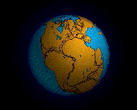
Precambrian
The Precambrian is the name which describes the large span of time in Earth's history before the current Phanerozoic Eon, and is a Supereon divided into several eons of the geologic time scale...
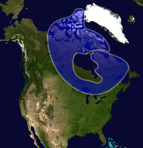
Canadian Shield
Canadian Shield
The Canadian Shield, also called the Laurentian Plateau, or Bouclier Canadien , is a vast geological shield covered by a thin layer of soil that forms the nucleus of the North American or Laurentia craton. It is an area mostly composed of igneous rock which relates to its long volcanic history...
and the Phanerozoic
Phanerozoic
The Phanerozoic Eon is the current eon in the geologic timescale, and the one during which abundant animal life has existed. It covers roughly 542 million years and goes back to the time when diverse hard-shelled animals first appeared...
Western Canadian Sedimentary Basin
Western Canadian Sedimentary Basin
The Western Canadian Sedimentary Basin is a vast sedimentary basin underlying of Western Canada including southwestern Manitoba, southern Saskatchewan, Alberta, northeastern British Columbia and the southwest corner of the Northwest Territories. It consists of a massive wedge of sedimentary rock...
. Within the Precambrian shield exists the Athabasca sedimentary basin. Meteorite impacts have altered the natural geological formation processes. The prairies were most recently affected by glacial events in the Quaternary period.
Canadian Shield
57th parallel north
The 57th parallel north is a circle of latitude that is 57 degrees north of the Earth's equatorial plane. It crosses Europe, Asia, the Pacific Ocean, North America, and the Atlantic Ocean....
in the north west to 54 degrees
54th parallel north
The 54th parallel north is a circle of latitude that is 54 degrees north of the Earth's equatorial plane. It crosses Europe, Asia, the Pacific Ocean, North America, and the Atlantic Ocean....
in the south east. Three orogenies
Orogeny
Orogeny refers to forces and events leading to a severe structural deformation of the Earth's crust due to the engagement of tectonic plates. Response to such engagement results in the formation of long tracts of highly deformed rock called orogens or orogenic belts...
formed the Precambrian shield, the Kenoran
Kenorland
Kenorland was one of the earliest supercontinents on Earth. It is believed to have formed during the Neoarchaean Era ~2.7 billion years ago by the accretion of Neoarchaean cratons and the formation of new continental crust...
(Laurentian-Algoman), Hudsonian
Trans-Hudson orogeny
The Trans-Hudson orogeny, Trans-Hudsonian orogeny, Trans-Hudson orogen , or Trans-Hudson Orogen Transect , , was the major mountain building event that formed the Precambrian Canadian Shield, the North American craton , and the...
(Penokean) and Grenville orogeny
Grenville orogeny
The Grenville Orogeny was a long-lived Mesoproterozoic mountain-building event associated with the assembly of the supercontinent Rodinia. Its record is a prominent orogenic belt which spans a significant portion of the North American continent, from Labrador to Mexico, as well as to Scotland...
. Between 2.2 and 2.5 billion years ago was the Kenoran orogeny, which was overlain by the Hudsonian Orogeny 1700 to 1900 million years ago. The earth was experiencing hotter and more volatile archean tectonics, evidencing island arc volcanic activity and mountain building. The Trans-Hudson Orogen occurred when a number of Archean continental blocks came together, including the Superior craton from the southeast and Hearne-Rae craton from the northwest. A microcontinent named the Sask craton
Trans-Hudson orogeny
The Trans-Hudson orogeny, Trans-Hudsonian orogeny, Trans-Hudson orogen , or Trans-Hudson Orogen Transect , , was the major mountain building event that formed the Precambrian Canadian Shield, the North American craton , and the...
was underlain in this collision zone. The Canadian Grenville province occurred between 1080 to 980 Ma and did not affect the geology of the Canadian Shield in Saskatchewan. The Grenvillian orogeny deformed much of eastern Canada, and includes the Grenville Front Tectonic Zone
Grenville Front Tectonic Zone
The Grenville Front Tectonic Zone is a geological feature in Eastern Canada that separates the Superior craton from rocks of the Grenville orogeny. It is a large tectonic zone of the Canadian Shield, extending from the northern shore of Lake Huron through Ontario and Quebec to Labrador, a distance...
in Quebec and Labrador, the Appalachian structural front to the south between what we now name the Great Lakes and Newfoundland.
The Flin Flon greenstone belt
Flin Flon greenstone belt
The Flin Flon greenstone belt, also referred to as the Flin Flon-Snow Lake greenstone belt, is a Precambrian greenstone belt located in the central area of Manitoba and east-central Saskatchewan, Canada . It lies in the central portion of the Trans-Hudson orogeny and was formed by arc volcanism...
, also referred to as the Flin Flon-Snow Lake greenstone belt, is a Precambrian
Precambrian
The Precambrian is the name which describes the large span of time in Earth's history before the current Phanerozoic Eon, and is a Supereon divided into several eons of the geologic time scale...
greenstone belt
Greenstone belt
Greenstone belts are zones of variably metamorphosed mafic to ultramafic volcanic sequences with associated sedimentary rocks that occur within Archaean and Proterozoic cratons between granite and gneiss bodies....
located in the central area of Manitoba
Manitoba
Manitoba is a Canadian prairie province with an area of . The province has over 110,000 lakes and has a largely continental climate because of its flat topography. Agriculture, mostly concentrated in the fertile southern and western parts of the province, is vital to the province's economy; other...
and east-central Saskatchewan
Saskatchewan
Saskatchewan is a prairie province in Canada, which has an area of . Saskatchewan is bordered on the west by Alberta, on the north by the Northwest Territories, on the east by Manitoba, and on the south by the U.S. states of Montana and North Dakota....
, Canada
Canada
Canada is a North American country consisting of ten provinces and three territories. Located in the northern part of the continent, it extends from the Atlantic Ocean in the east to the Pacific Ocean in the west, and northward into the Arctic Ocean...
. It lies in the central portion of the Trans-Hudson orogeny
Trans-Hudson orogeny
The Trans-Hudson orogeny, Trans-Hudsonian orogeny, Trans-Hudson orogen , or Trans-Hudson Orogen Transect , , was the major mountain building event that formed the Precambrian Canadian Shield, the North American craton , and the...
and was formed by arc volcanism
Volcanic arc
A volcanic arc is a chain of volcanoes positioned in an arc shape as seen from above. Offshore volcanoes form islands, resulting in a volcanic island arc. Generally they result from the subduction of an oceanic tectonic plate under another tectonic plate, and often parallel an oceanic trench...
during the Paleoproterozoic
Paleoproterozoic
The Paleoproterozoic is the first of the three sub-divisions of the Proterozoic occurring between . This is when the continents first stabilized...
period.
Athabasca basin
The Athabasca basinAthabasca Basin
This article is about the uranium mining region near Lake Athabasca. Not to be confused with the drainage basin of the Athabasca River.The Athabasca Basin is a region of Northern Saskatchewan and Alberta Canada that is best known as the world's leading source of high grade uranium...
, a historical shallow tropical sea basin filled with sediments from the Hudsonian mountains. The Athabasca basin was formed during the Statherian or Paleohelikian
Statherian
The Statherian is the final geologic period in the Paleoproterozoic Era and lasted from 1800 Mya to 1600 Mya . Instead of being based on stratigraphy, these dates are defined chronometrically....
1.7 to 1.6 billion years ago when coarse fluvial and marine clastic sediments were laid down containing gold, copper, lead, zinc, and uranium oxides. The highest grade uranium deposits in the world are found at the unconformity between these clastic layers and the Precambrian bedrock. The Athabasca Sand Hills protected by The Athabasca Sand Dunes Provincial Park
Athabasca Sand Dunes Provincial Park
Athabasca Sand Dunes Provincial Park is a unique geophysical land feature in the boreal shield ecosystem of the province of Saskatchewan. It first came to attention that it should be a protected area in 1969, finally becoming the Athabasca Sand Dunes Provincial Wilderness Park on August 24, 1992. ...
are unique feature of the Canadian shield. The hills are located in northern Saskatchewan and border Lake Athabasca, which straddles the Alberta and Saskatchewan border.
Phanerozoic Western Canadian Sedimentary Basin
There were three depositional stages for the Western Canada Sedimentary BasinWestern Canadian Sedimentary Basin
The Western Canadian Sedimentary Basin is a vast sedimentary basin underlying of Western Canada including southwestern Manitoba, southern Saskatchewan, Alberta, northeastern British Columbia and the southwest corner of the Northwest Territories. It consists of a massive wedge of sedimentary rock...
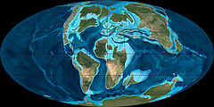
which were dependent on plate tectonics of the era. Present-day North America was identified to lay upon the Proterozoic super-continent, Rodinia
Rodinia
In geology, Rodinia is the name of a supercontinent, a continent which contained most or all of Earth's landmass. According to plate tectonic reconstructions, Rodinia existed between 1.1 billion and 750 million years ago, in the Neoproterozoic era...
.
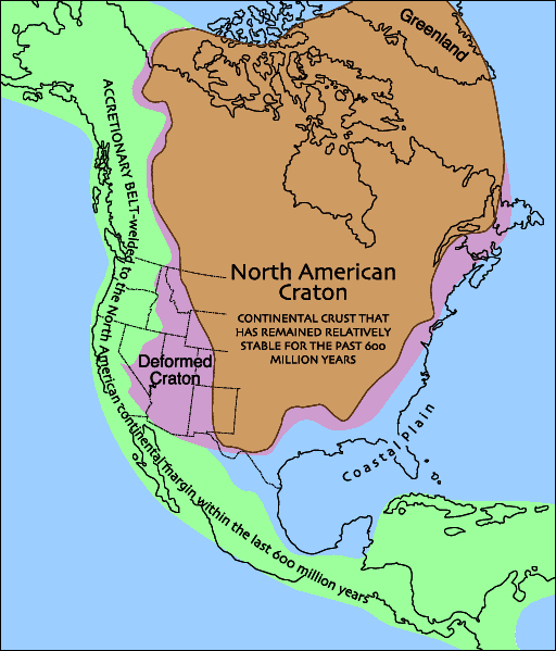
Laurentia
Laurentia is a large area of continental craton, which forms the ancient geological core of the North American continent...
or the North American Craton. Laurentia drifted south of the equatorial zone. As this new smaller continent was smaller than Rodrina, it had some surface area under water level, including area designated as the phanerozoic basin. Cambrian
Cambrian
The Cambrian is the first geological period of the Paleozoic Era, lasting from Mya ; it is succeeded by the Ordovician. Its subdivisions, and indeed its base, are somewhat in flux. The period was established by Adam Sedgwick, who named it after Cambria, the Latin name for Wales, where Britain's...
544-505 Ma to Mississippian 362-320 Ma period laid down base clastics, then platform carbonates and evaporites. These deposits form the origins of potash
Potash
Potash is the common name for various mined and manufactured salts that contain potassium in water-soluble form. In some rare cases, potash can be formed with traces of organic materials such as plant remains, and this was the major historical source for it before the industrial era...
evaporites for the potash industry. Laurentia began to rise at the close of the Cambrian era. Huge flooding occurred during the Middle Ordovician
Ordovician
The Ordovician is a geologic period and system, the second of six of the Paleozoic Era, and covers the time between 488.3±1.7 to 443.7±1.5 million years ago . It follows the Cambrian Period and is followed by the Silurian Period...
period 505-441 Ma. Laurentia had shifted again, and the region of Saskatchewan was now north of the equator and some raising exposing the land again. Re-flooding in the Late Ordovician age with warm water increased calcium carbonate sedimentation, and marine life.
Williston Basin
The Williston Basin is a large intracratonic sedimentary basin in eastern Montana, western North and South Dakota, and southern Saskatchewan known for its rich deposits of petroleum and potash. The basin is a geologic structural basin but not a topographic depression; it is transected by the...
was formed creating a lowered land area during this period filling with the Winnipeg Sea. The Williston basin was mainly south of Saskatchewan but extended north into the Saskatchewan plains area.
Laurasia was created near the end of the Silurian
Silurian
The Silurian is a geologic period and system that extends from the end of the Ordovician Period, about 443.7 ± 1.5 Mya , to the beginning of the Devonian Period, about 416.0 ± 2.8 Mya . As with other geologic periods, the rock beds that define the period's start and end are well identified, but the...
period. Laurasia was formed from the joining of Laurentia with Gondwana and two smaller continents which had broken off Rodrina. The orogeny between Laurasia and Gondwana created the Appalachian Mountains, and an exodus of water from the Laurasian land surface. In the early Devonian
Devonian
The Devonian is a geologic period and system of the Paleozoic Era spanning from the end of the Silurian Period, about 416.0 ± 2.8 Mya , to the beginning of the Carboniferous Period, about 359.2 ± 2.5 Mya...
period 418-361 Ma, Laurasia separated from Gondwana, creating a depressions or land separations through the continent. One low-lying area occurred along the edge between the Cambrian shield and the Phanerozoic basin, the other trough lay along southwestern Saskatchewan extending east and west along the plains areas we know today. The Saskatchewan region was again south of the equator and under water, with reefs forming. A major barrier reef formed in the area now known as British Columbia, creating higher salinity levels east of the reef. Calcium carbonate, halite, gypsum, and potash were clastic deposits. The Antler orogeny
Antler orogeny
The Antler orogeny is a mountain-building episode that is named for Antler Peak, at Battle Mountain, Nevada. The orogeny extensively deformed Paleozoic rocks of the Great Basin in Nevada and western Utah during Late Devonian and Early Mississippian time...
on the southwest coast of Laurassia caused upheavals.
Following this orogeny, during the Carboniferous
Carboniferous
The Carboniferous is a geologic period and system that extends from the end of the Devonian Period, about 359.2 ± 2.5 Mya , to the beginning of the Permian Period, about 299.0 ± 0.8 Mya . The name is derived from the Latin word for coal, carbo. Carboniferous means "coal-bearing"...
period in the Mississippian epoch 362-320 Ma the Willistin basin again subsided and the area of the Phanerozoic basin was again mainly under tropical marine water. Oil production
Athabasca Oil Sands
The Athabasca oil sands are large deposits of bitumen, or extremely heavy crude oil, located in northeastern Alberta, Canada - roughly centred on the boomtown of Fort McMurray...
of southeastern Saskatchewan emerges mainly from Mississippian rocks.
Pennsylvanian
The Pennsylvanian is, in the ICS geologic timescale, the younger of two subperiods of the Carboniferous Period. It lasted from roughly . As with most other geochronologic units, the rock beds that define the Pennsylvanian are well identified, but the exact date of the start and end are uncertain...
epoch 320-286 Ma of the Carboniferous period, Laurasia joined with Gondwana to become Pangea. This supercontinent
Supercontinent
In geology, a supercontinent is a landmass comprising more than one continental core, or craton. The assembly of cratons and accreted terranes that form Eurasia qualifies as a supercontinent today.-History:...
rose above sea level, in an equatorial zone producing desert-like conditions.
Triassic
The Triassic is a geologic period and system that extends from about 250 to 200 Mya . As the first period of the Mesozoic Era, the Triassic follows the Permian and is followed by the Jurassic. Both the start and end of the Triassic are marked by major extinction events...
245-208 Ma or early Jurassic
Jurassic
The Jurassic is a geologic period and system that extends from about Mya to Mya, that is, from the end of the Triassic to the beginning of the Cretaceous. The Jurassic constitutes the middle period of the Mesozoic era, also known as the age of reptiles. The start of the period is marked by...
208-144 Ma to Jura-Cretaceous 208-66 Ma where red clay beds and marine clastics were deposited. Pangea began to separate during the Jurassic period.
The Kimberlite Volcanoes of this period produce the Kimberlite diamonds
Fort à la Corne kimberlite field
The Fort à la Corne kimberlite field is a 104-95 million year old diamond-bearing kimberlite field in east-central Saskatchewan, Canada. Its kimberlite pipes are among the most complete examples in the world, preserving maar-shaped craters.-See also:...
which are mined today. Near Fort à La Corne (FALC) were Kimberlite volcanoes in Archean cratons.
Cretaceous
The Cretaceous , derived from the Latin "creta" , usually abbreviated K for its German translation Kreide , is a geologic period and system from circa to million years ago. In the geologic timescale, the Cretaceous follows the Jurassic period and is followed by the Paleogene period of the...
144-66 Ma to Miocene
Miocene
The Miocene is a geological epoch of the Neogene Period and extends from about . The Miocene was named by Sir Charles Lyell. Its name comes from the Greek words and and means "less recent" because it has 18% fewer modern sea invertebrates than the Pliocene. The Miocene follows the Oligocene...
periods deposited clastic sediments from the Cordilleran orogeny. This period saw 40% of the region now called North America below sea level under the Rocky Mountain Seaway
Geology of the Rocky Mountains
The geology of the Rocky Mountains is that of a discontinuous series of mountain ranges with distinct geological origins. Collectively these make up the Rocky Mountains, a mountain system that stretches from Canada through central New Mexico and which is part of the great mountain system known as...
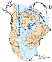
which comprised the Western Interior Seaway
Western Interior Seaway
The Western Interior Seaway, also called the Cretaceous Seaway, the Niobraran Sea, and the North American Inland Sea, was a huge inland sea that split the continent of North America into two halves, Laramidia and Appalachia, during most of the mid- and late-Cretaceous Period...
and the Hudson Seaway, and Labrador Seaway. The Cretaceous period rocks produce medium and heavy gravity oil in the Lloydminster region, and of the western province. The Laramide orogeny
Laramide orogeny
The Laramide orogeny was a period of mountain building in western North America, which started in the Late Cretaceous, 70 to 80 million years ago, and ended 35 to 55 million years ago. The exact duration and ages of beginning and end of the orogeny are in dispute, as is the cause. The Laramide...
episode near the end of the Cretacsous and early Tertiary
Tertiary
The Tertiary is a deprecated term for a geologic period 65 million to 2.6 million years ago. The Tertiary covered the time span between the superseded Secondary period and the Quaternary...
period caused larger gravels to be deposited from the newly formed Rocky Mountains when the Kula
Kula Plate
The Kula Plate is an oceanic tectonic plate under the northern Pacific Ocean south of the Near Islands segment of the Aleutian Islands. It is subducting under the North American Plate at the Aleutian Trench and is surrounded by the Pacific Plate...
and Farallon Plate
Farallon Plate
The Farallon Plate was an ancient oceanic plate, which began subducting under the west coast of the North American Plate— then located in modern Utah— as Pangaea broke apart during the Jurassic Period...
s subducted below the North American plate
North American Plate
The North American Plate is a tectonic plate covering most of North America, Greenland, Cuba, Bahamas, and parts of Siberia, Japan and Iceland. It extends eastward to the Mid-Atlantic Ridge and westward to the Chersky Range in eastern Siberia. The plate includes both continental and oceanic crust...
. In the Cypress Hills area and southern Saskatchewan, lignite deposits developed from the marshes of these Tertiary rivers. The sea waters have retreated from the areas known as Saskatchewan. The Ravenscrag formation, Cypress Hills, and Wood Mountain Formations were notable gravel deposits from the Tertiary period. The Willistin Basin
Williston Basin
The Williston Basin is a large intracratonic sedimentary basin in eastern Montana, western North and South Dakota, and southern Saskatchewan known for its rich deposits of petroleum and potash. The basin is a geologic structural basin but not a topographic depression; it is transected by the...
affects this region at the southern edge. Tectonic movements and global changes in the sea level have given rise to a source of oil, natural gas, and coal.
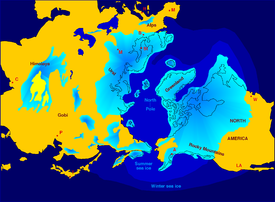
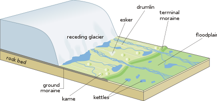
Quaternary period
During the QuaternaryQuaternary
The Quaternary Period is the most recent of the three periods of the Cenozoic Era in the geologic time scale of the ICS. It follows the Neogene Period, spanning 2.588 ± 0.005 million years ago to the present...
period, between 2 to 3 million years ago, the prairies were covered by a glacier, the Laurentide ice sheet
Laurentide ice sheet
The Laurentide Ice Sheet was a massive sheet of ice that covered hundreds of thousands of square miles, including most of Canada and a large portion of the northern United States, multiple times during Quaternary glacial epochs. It last covered most of northern North America between c. 95,000 and...
.
Ice age
An ice age or, more precisely, glacial age, is a generic geological period of long-term reduction in the temperature of the Earth's surface and atmosphere, resulting in the presence or expansion of continental ice sheets, polar ice sheets and alpine glaciers...
. The newest of geological events occurred during the Quaternary period when comprises the last two million years. Northern Saskatchewan and the shield area shows the effects of glacial erosion and scour; the Western Canada Sedimentary Basin is a location of glacial deposition and collection. In southern Saskatchewan there are late Pliocene, pre-Illinoian continental glaciation sand and gravel deposits left behind from water deposition (alluvial) and glacial edge deposits (colluvial
Colluvium
Colluvium is the name for loose bodies of sediment that have been deposited or built up at the bottom of a low-grade slope or against a barrier on that slope, transported by gravity. The deposits that collect at the foot of a steep slope or cliff are also known by the same name. Colluvium often...
). By the study of till, terrain, the limits of the Illinoian glaciation are evidenced around Willow Bunch Lake, Wood Mountain, Cypress Hills area.
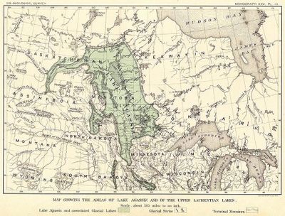
Lake Agassiz
Lake Agassiz was an immense glacial lake located in the center of North America. Fed by glacial runoff at the end of the last glacial period, its area was larger than all of the modern Great Lakes combined, and it held more water than contained by all lakes in the world today.-Conception:First...
covered much of Saskatchewan and neighboring regions of the US
United States
The United States of America is a federal constitutional republic comprising fifty states and a federal district...
and Manitoba
Manitoba
Manitoba is a Canadian prairie province with an area of . The province has over 110,000 lakes and has a largely continental climate because of its flat topography. Agriculture, mostly concentrated in the fertile southern and western parts of the province, is vital to the province's economy; other...
. The ice and water retreated, and the lake beds formed flat plains. The land exposed from under the ice sheets was rubble, and ridges of gravel.
Glaciotectonic hills
The Dirt Hills and Cactus Hills represent the most defined and biggest Møns Klint glaciotectonic hills of the world. There are other similar hills created by ice action in southern Saskatchewan as well. Glaciotectonic hills or ice-shoved hills show thrusting, folds, ridges and push moraineMoraine
A moraine is any glacially formed accumulation of unconsolidated glacial debris which can occur in currently glaciated and formerly glaciated regions, such as those areas acted upon by a past glacial maximum. This debris may have been plucked off a valley floor as a glacier advanced or it may have...
s. These hills consist of upper Cretaceous bedrock which rises to an elevation of 880 metres (2,887.1 ft) in the Dirt Hills. To the north is the Regina Lake Plain which is 300 metres (984.3 ft) lower in elevation. The Missouri Coteau from whence the hills arise, is 120 metres (393.7 ft) lower than these hills. Between the Alberta and Saskatchewan Plains is the Missouri Coteau, dead ice moraine, a major escarpment
Escarpment
An escarpment is a steep slope or long cliff that occurs from erosion or faulting and separates two relatively level areas of differing elevations.-Description and variants:...
, a long meandering ridge of hill country. The area is probably underlain with marine shale of the Bearpaw Formation
Bearpaw Formation
The Bearpaw Formation, also called the Bearpaw Shale, is a sedimentary rock formation found in northwestern North America. It is exposed in the U.S. state of Montana, as well as the Canadian provinces of Alberta and Saskatchewan, east of the Rocky Mountains...
. This area remained above the ice sheets, being pushed and folded by the glacier movement.
Astroblemes
There are six notable meteorite or comet impact craters in Saskatchewan. Carswell, Deep Bay, and Gow Lake have affected the Canadian Shield area of the north. In the southern Phanerozoic crater are the Viewfield, Elbow, and Maple Creek structures. The Carswell structureCarswell crater
Carswell is an impact crater in northern Saskatchewan, Canada. It is in diameter and the age is estimated to be 115 ± 10 million years . The crater is exposed at the surface....
is the largest astrobleme at 35 kilometres (21.7 mi) in diameter. It is estimated that the impact to the Athabasca basin occurred about 478 million years ago during the Ordovician
Ordovician
The Ordovician is a geologic period and system, the second of six of the Paleozoic Era, and covers the time between 488.3±1.7 to 443.7±1.5 million years ago . It follows the Cambrian Period and is followed by the Silurian Period...
period. The thrust of the impact affected the Athabasca Rock groups. The William River Subgroup and the Douglas and Carswell formations show inversions, thrusting and disruptions. The impact that occurred about 210 million years ago has created the Gow Lake Structure
Gow crater
Gow is an impact crater in Saskatchewan, Canada.It is 4 km in diameter and the age is estimated to be less than 250 million years . The crater contains a classic crater lake with an island formed by the central uplift....
. This lake is 5 kilometres (3.1 mi) in diameter with Calder island centrally located. La Ronge
La Ronge, Saskatchewan
La Ronge is a community of about 2,700 people in Northern Saskatchewan, Canada, 250 km north of Prince Albert. There are an additional 2,000 people living in the Lac La Ronge First Nation bordering the town, and another 1,000 people living in the neighbouring community of Air Ronge...
is 160 kilometres (99.4 mi) south-southwest of the crater location. The other impact crater of the Cambrian shield is the Deep Bay Structure
Deep Bay crater
Deep Bay is a bay near the south-western tip of Reindeer Lake in Saskatchewan, Canada. The bay is strikingly circular and very deep in an otherwise irregular and shallow lake....
, which created a bay in the southerly part of Reindeer Lake. The crater is about 11 kilometres (6.8 mi) in diameter and about 220 metres (721.8 ft) at the deepest point. The circular impact ridge 100 metres (328.1 ft) above water level partially encompasses the crater area. There is some central uplift. The crater was formed about 50 to 150 million years ago. Weyburn
Weyburn, Saskatchewan
Weyburn is a city in southeastern Saskatchewan, Canada. It is located on the Souris River southeast of the provincial capital of Regina and is north of the border with the United States. The name is reputedly a corruption of the Scottish "wee burn," referring to a small creek. The city is...
is west and Stoughton
Stoughton, Saskatchewan
Stoughton is a town in Saskatchewan, Canada. A small police service, the Stoughton Police Service no longer exists and is now in partnership with the Royal Canadian Mounted Police to provide policing service to the town and surrounding area.-Demographics:...
is north of the Viewfield Impact Structure
Viewfield crater
Viewfield is an impact crater in Saskatchewan, Canada.It is 2.5 km in diameter and the age is estimated to be 190 ± 20 million years . The crater is not exposed at the surface.- References :...
, a small impact crater 2 kilometres (1.2 mi) in diameter. The impact occurred in the early Jurassic
Jurassic
The Jurassic is a geologic period and system that extends from about Mya to Mya, that is, from the end of the Triassic to the beginning of the Cretaceous. The Jurassic constitutes the middle period of the Mesozoic era, also known as the age of reptiles. The start of the period is marked by...
period about 190 million years ago. Oil and gas reserves have been found in the area of the rim breccia Another impact crater in the Phanerezoic crater is the Maple Creek Structure
Maple Creek crater
Maple Creek is a subterranean meteorite crater in Saskatchewan, Canada. It is 6 km in diameter and the age is estimated to be less than 75 million years . The crater is buried beneath younger sediments and cannot be seen at the surface....
. This impact affected Upper Cretaceous Bearpaw Formation sediments on the north edge of the Cypress Hills, and roughly occurred 75 million years ago. Maple Creek
Maple Creek, Saskatchewan
-History:After the North-West Mounted Police had been established at Fort Walsh, settlers began to explore the Cypress Hills area, living along the creeks and doing small-scale ranching. The Department of the Interior was operating a First Nations farm on the Maple Creek, a few miles south from...
is located north northwest of this 6 kilometres (3.7 mi) diameter crater. The Elbow Impact Structure
Elbow crater
Elbow is a meteorite crater just north of the village of Riverhurst in Saskatchewan, Canada.The crater is in diameter with an age estimated to be 395 ± 25 million years . The crater is buried beneath younger sediments and is not exposed at the surface.- References :...
is 8 kilometres (5 mi) in diameter and the impact occurred between 370 to 415 million years ago during the Devonian
Devonian
The Devonian is a geologic period and system of the Paleozoic Era spanning from the end of the Silurian Period, about 416.0 ± 2.8 Mya , to the beginning of the Carboniferous Period, about 359.2 ± 2.5 Mya...
Period. The crater is located in Maple Bush
Maple Bush No. 224, Saskatchewan
The RM of Maple Bush No.224 is located in southwestern Saskatchewan, Canada it surrounds the outskirts of Elbow.Maple Bush, Saskatchewan tourism attracts many visitors each summer due to the lake to which it is connected and the provincial park known as Douglas Park.According to the Canada 2001...
rural municipality
Rural municipality
A rural municipality, often abbreviated RM, is a form of municipality in the Canadian provinces of Manitoba and Saskatchewan, perhaps best comparable to counties or townships in the western United States...
north of Aitkow and west of Grainfield. The Elbow crater is located south of the elbow of the South Saskatchewan, and south of Diefenbaker lake across the waters from the town of Elbow
Elbow, Saskatchewan
- See also :* List of communities in Saskatchewan* Villages of Saskatchewan* Elbow-External links:*** Encyclopedia of Saskatchewan-Footnotes:...
which is north of the South Saskatchewan River
South Saskatchewan River
The South Saskatchewan River is a major river in Canada that flows through the provinces of Alberta and Saskatchewan....
.
See also
- Volcanism in CanadaVolcanism in CanadaVolcanism of Canada has produced lava flows, lava plateaus, lava domes, cinder cones, stratovolcanoes, shield volcanoes, submarine volcanoes, calderas, diatremes, and maars, along with examples of more less common volcanic forms such as tuyas and subglacial mounds...
- Bearpaw FormationBearpaw FormationThe Bearpaw Formation, also called the Bearpaw Shale, is a sedimentary rock formation found in northwestern North America. It is exposed in the U.S. state of Montana, as well as the Canadian provinces of Alberta and Saskatchewan, east of the Rocky Mountains...
- Frenchman FormationFrenchman FormationThe Frenchman Formation is a division of Upper Cretaceous rocks found in Saskatchewan, Canada. More accurately described as Late Maastrichtian, these rocks contain the youngest of dinosaur genera, much like the Hell Creek Formation in the United States....
- Judith River GroupJudith River GroupThe Judith River Group is a group of geologic formations in western North America dating from the late Cretaceous and noted as a site for the extensive excavation of dinosaur fossils. The formation is named after the Judith River in Montana. The group is also called the Judith River Wedge...
- Maastrichtian (geological period)
- Morrison FormationMorrison FormationThe Morrison Formation is a distinctive sequence of Late Jurassic sedimentary rock that is found in the western United States, which has been the most fertile source of dinosaur fossils in North America. It is composed of mudstone, sandstone, siltstone and limestone and is light grey, greenish...
- Nevadan orogenyNevadan orogenyThe Nevadan Orogeny was a major mountain building event that took place along the western edge of ancient North America between the Mid to Late Jurassic...
- Superior cratonSuperior cratonThe Superior craton forms the core of the Canadian Shield at the heart of the North American continent. It extends from Quebec in the east to eastern Manitoba in the west...
- Kenora orogeny - Sevier orogenySevier orogenyThe Sevier orogeny was a mountain-building event that affected western North America from Canada to the north to Mexico to the south. This orogeny was the result of convergent boundary tectonic activity between approximately 140 million years ago and 50 Ma. The Sevier River area of central Utah...
- Wyoming cratonWyoming cratonThe Wyoming craton is a craton located in the west-central United States and western Canada – more specifically, in Montana, Wyoming, southern Alberta, southern Saskatchewan, and parts of northern Utah...
External links
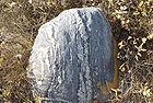
Ethnohistorical geography of SaskatchewanImage of fractured cobbles at Dollard
Dollard, Saskatchewan
Dollard is a small village situated on the historic Red Coat Trail in the southwest corner of Saskatchewan, Canada. It is 13 km west of the town of Shaunavon and 21 km east of the town of Eastend...
Saskatchewan
Saskatchewan
Saskatchewan is a prairie province in Canada, which has an area of . Saskatchewan is bordered on the west by Alberta, on the north by the Northwest Territories, on the east by Manitoba, and on the south by the U.S. states of Montana and North Dakota....