Lake Agassiz was an immense
glacial lakeA glacial lake is a lake with origins in a melted glacier. Near the end of the last glacial period, roughly 10,000 years ago, glaciers began to retreat. A retreating glacier often left behind large deposits of ice in hollows between drumlins or hills. As the ice age ended, these melted to create...
located in the center of
North AmericaNorth America is a continent wholly within the Northern Hemisphere and almost wholly within the Western Hemisphere. It is also considered a northern subcontinent of the Americas...
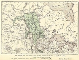
. Fed by glacial runoff at the end of the last glacial period, its area was larger than all of the modern
Great LakesThe Great Lakes are a collection of freshwater lakes located in northeastern North America, on the Canada – United States border. Consisting of Lakes Superior, Michigan, Huron, Erie, and Ontario, they form the largest group of freshwater lakes on Earth by total surface, coming in second by volume...
combined, and it held more water than contained by all lakes in the world today.
Conception
First postulated in 1823 by William Keating, it was named by
Warren UphamWarren Upham was a geologist, archaeologist, and librarian who is best known for his studies of glacial Lake Agassiz. Upham worked as a geologist in New Hampshire before moving in 1879 to Minnesota to study the resources and glacial geology of that state...
in 1879 after
Louis AgassizJean Louis Rodolphe Agassiz was a Swiss paleontologist, glaciologist, geologist and a prominent innovator in the study of the Earth's natural history. He grew up in Switzerland and became a professor of natural history at University of Neuchâtel...
, after Upham recognized it was formed by glacial action.
Geological progression
Geologists have come to a consensus on the likely geological history of Lake Agassiz.
During the last
Ice AgeAn ice age or, more precisely, glacial age, is a generic geological period of long-term reduction in the temperature of the Earth's surface and atmosphere, resulting in the presence or expansion of continental ice sheets, polar ice sheets and alpine glaciers...
, northern North America was covered by a glacier, which alternately advanced and deteriorated with variations in the climate. This continental ice sheet formed during the period now known as the Wisconsin glaciation, and covered much of central North America between 30,000 and 10,000 years ago. As the ice sheet disintegrated, it created at its front an immense
proglacial lakeIn geology, a proglacial lake is a lake formed either by the damming action of a moraine or ice dam during the retreat of a melting glacier, or by meltwater trapped against an ice sheet due to isostatic depression of the crust around the ice...
, formed from its meltwaters.
Around 13,000 years
BPBefore Present years is a time scale used in archaeology, geology, and other scientific disciplines to specify when events in the past occurred. Because the "present" time changes, standard practice is to use AD 1950 as the origin of the age scale, reflecting the fact that radiocarbon...
the lake came to cover much of
ManitobaManitoba is a Canadian prairie province with an area of . The province has over 110,000 lakes and has a largely continental climate because of its flat topography. Agriculture, mostly concentrated in the fertile southern and western parts of the province, is vital to the province's economy; other...
, western
OntarioOntario is a province of Canada, located in east-central Canada. It is Canada's most populous province and second largest in total area. It is home to the nation's most populous city, Toronto, and the nation's capital, Ottawa....
, northern
MinnesotaMinnesota is a U.S. state located in the Midwestern United States. The twelfth largest state of the U.S., it is the twenty-first most populous, with 5.3 million residents. Minnesota was carved out of the eastern half of the Minnesota Territory and admitted to the Union as the thirty-second state...
, eastern
North DakotaNorth Dakota is a state located in the Midwestern region of the United States of America, along the Canadian border. The state is bordered by Canada to the north, Minnesota to the east, South Dakota to the south and Montana to the west. North Dakota is the 19th-largest state by area in the U.S....
, and
SaskatchewanSaskatchewan is a prairie province in Canada, which has an area of . Saskatchewan is bordered on the west by Alberta, on the north by the Northwest Territories, on the east by Manitoba, and on the south by the U.S. states of Montana and North Dakota....
. At its greatest extent, it may have covered as much as 440,000 square kilometers, larger than any currently existing lake in the world (including the
Caspian SeaThe Caspian Sea is the largest enclosed body of water on Earth by area, variously classed as the world's largest lake or a full-fledged sea. The sea has a surface area of and a volume of...
).
The lake drained at various times south through the
Traverse GapThe Traverse Gap is an ancient river channel occupied by Lake Traverse and Big Stone Lake and the valley connecting them at Browns Valley, Minnesota. It is located on the border of the U.S. states of Minnesota and South Dakota...
into
Glacial River Warrenright|thumb|210px|The course of the Minnesota River follows the valley carved by Glacial River WarrenGlacial River Warren or River Warren was a prehistoric river that drained Lake Agassiz in central North America between 11,700 and 9,400 years ago...
(parent to the
Minnesota RiverThe Minnesota River is a tributary of the Mississippi River, approximately 332 miles long, in the U.S. state of Minnesota. It drains a watershed of nearly , in Minnesota and about in South Dakota and Iowa....
, a tributary of the
Mississippi RiverThe Mississippi River is the largest river system in North America. Flowing entirely in the United States, this river rises in western Minnesota and meanders slowly southwards for to the Mississippi River Delta at the Gulf of Mexico. With its many tributaries, the Mississippi's watershed drains...
), east through Lake Kelvin (modern
Lake NipigonLake Nipigon is the largest lake entirely within the boundaries of the Canadian province of Ontario . It is sometimes described as the sixth Great Lake. Lying 260 metres above sea level, the lake drains into the Nipigon River and thence into Nipigon Bay of Lake Superior...
) to what is now
Lake SuperiorLake Superior is the largest of the five traditionally-demarcated Great Lakes of North America. It is bounded to the north by the Canadian province of Ontario and the U.S. state of Minnesota, and to the south by the U.S. states of Wisconsin and Michigan. It is the largest freshwater lake in the...
, or west via the
Mackenzie RiverThe Mackenzie River is the largest river system in Canada. It flows through a vast, isolated region of forest and tundra entirely within the country's Northwest Territories, although its many tributaries reach into four other Canadian provinces and territories...
through the
Northwest TerritoriesThe Northwest Territories is a federal territory of Canada.Located in northern Canada, the territory borders Canada's two other territories, Yukon to the west and Nunavut to the east, and three provinces: British Columbia to the southwest, and Alberta and Saskatchewan to the south...
.
GeologistA geologist is a scientist who studies the solid and liquid matter that constitutes the Earth as well as the processes and history that has shaped it. Geologists usually engage in studying geology. Geologists, studying more of an applied science than a theoretical one, must approach Geology using...
s have found evidence that a major outbreak of Lake Agassiz about 13,000 BP drained north through the
Mackenzie RiverThe Mackenzie River is the largest river system in Canada. It flows through a vast, isolated region of forest and tundra entirely within the country's Northwest Territories, although its many tributaries reach into four other Canadian provinces and territories...
into the
Arctic OceanThe Arctic Ocean, located in the Northern Hemisphere and mostly in the Arctic north polar region, is the smallest and shallowest of the world's five major oceanic divisions...
. A return of the ice for some time offered a reprieve, but after retreating north of the Canada – United States border about 9,900 years ago, Lake Agassiz refilled. The last major shift in drainage occurred about 8,400 years BP. The melting of remaining
Hudson BayHudson Bay , sometimes called Hudson's Bay, is a large body of saltwater in northeastern Canada. It drains a very large area, about , that includes parts of Ontario, Quebec, Saskatchewan, Alberta, most of Manitoba, southeastern Nunavut, as well as parts of North Dakota, South Dakota, Minnesota,...
ice caused lake Agassiz to drain nearly completely. This final drainage of Lake Agassiz contributed an estimated 1 to 3 meters to total post-glacial global sea level rise. Much of the final drainage may have occurred in a very short time, in one or two events, perhaps taking as little as a year.
Lake Agassiz' major drainage reorganization events were of such magnitudes that they had significant impact on climate, sea level and possibly early human civilization. Major freshwater release into the
Arctic OceanThe Arctic Ocean, located in the Northern Hemisphere and mostly in the Arctic north polar region, is the smallest and shallowest of the world's five major oceanic divisions...
is considered to disrupt oceanic circulation and cause temporary cooling. The draining at 13,000 may be the cause of the
Younger DryasThe Younger Dryas stadial, also referred to as the Big Freeze, was a geologically brief period of cold climatic conditions and drought between approximately 12.8 and 11.5 ka BP, or 12,800 and 11,500 years before present...
stadialA stadial is a period of lower temperatures during an interglacial separating the glacial periods of an ice age. Such periods are of insufficient duration or intensity to be considered glacial periods...
. The draining at 8,400 may be the cause of the
8,200 yr climate eventThe 8.2 kiloyear event is the term that climatologists have adopted for a sudden decrease in global temperatures that occurred approximately 8,200 years before the present, or c. 6,200 BCE, and which lasted for the next two to four centuries...
. A recent study by Turney and Brown links the 8,400 drainage to the expansion of agriculture from east to west across Europe; he suggests that this may also account for various flood myths of prehistoric cultures, including the Biblical flood.
Remnants and effects
Lake WinnipegLake Winnipeg is a large, lake in central North America, in the province of Manitoba, Canada, with its southern tip about north of the city of Winnipeg...
,
Lake WinnipegosisLake Winnipegosis is a large lake in central North America, in Manitoba, Canada, some 300 km northwest of Winnipeg. It is Canada's eleventh-largest lake...
,
Lake ManitobaLake Manitoba is Canada's thirteenth largest lake and the world's 33rd largest freshwater lake. It is in central North America, in the Canadian province of Manitoba, which is named after the lake...
, and
Lake of the WoodsLake of the Woods is a lake occupying parts of the Canadian provinces of Ontario and Manitoba and the U.S. state of Minnesota. It separates a small land area of Minnesota from the rest of the United States. The Northwest Angle and the town of Angle Township can only be reached from the rest of...
, among others, are relics of the ancient lake. The outlines and volumes of these modern lakes are still slowly changing due to differential isostatic rebound.
Other geological and geomorphological evidence for Lake Agassiz can also be seen today.
Raised beachA raised beach, marine terrace, or perched coastline is an emergent coastal landform. Raised beaches and marine terraces are beaches or wave-cut platforms raised above the shore line by a relative fall in the sea level ....
es, many kilometers from any water, mark the former boundaries of the lake at various times. Several modern river valleys, including those of the
Assiniboine RiverThe Assiniboine River is a river that runs through the prairies of Western Canada in Saskatchewan and Manitoba. It is a tributary of the Red River. The Assiniboine is a typical meandering river with a single main channel embanked within a flat, shallow valley in some places and a steep valley in...
and the
Minnesota RiverThe Minnesota River is a tributary of the Mississippi River, approximately 332 miles long, in the U.S. state of Minnesota. It drains a watershed of nearly , in Minnesota and about in South Dakota and Iowa....
, were originally cut by water entering or leaving the lake. The fertile soils of the
Red River ValleyThe Red River Valley is a region in central North America that is drained by the Red River of the North. It is significant in the geography of North Dakota, Minnesota, and Manitoba for its relatively fertile lands and the population centers of Fargo, Moorhead, Grand Forks, and Winnipeg...
, now drained by the
Red River of the NorthThe Red River is a North American river. Originating at the confluence of the Bois de Sioux and Otter Tail rivers in the United States, it flows northward through the Red River Valley and forms the border between the U.S. states of Minnesota and North Dakota before continuing into Manitoba, Canada...
, are formed from
lacustrineA lake is a body of relatively still fresh or salt water of considerable size, localized in a basin, that is surrounded by land. Lakes are inland and not part of the ocean and therefore are distinct from lagoons, and are larger and deeper than ponds. Lakes can be contrasted with rivers or streams,...
deposits of
siltSilt is granular material of a size somewhere between sand and clay whose mineral origin is quartz and feldspar. Silt may occur as a soil or as suspended sediment in a surface water body...
from Lake Agassiz.
See also
- Glacial lake outburst flood
A glacial lake outburst flood is a type of outburst flood that occurs when the dam containing a glacial lake fails. The dam can consist of glacier ice or a terminal moraine...
- Glacial River Warren
right|thumb|210px|The course of the Minnesota River follows the valley carved by Glacial River WarrenGlacial River Warren or River Warren was a prehistoric river that drained Lake Agassiz in central North America between 11,700 and 9,400 years ago...
- Glacial history of Minnesota
The glacial history of Minnesota is most defined since the onset of the last glacial period, which ended some 10,000 years ago. Within the last million years, most of the Midwestern United States and much of Canada were covered at one time or another with an ice sheet. This continental glacier had...
- Younger Dryas
The Younger Dryas stadial, also referred to as the Big Freeze, was a geologically brief period of cold climatic conditions and drought between approximately 12.8 and 11.5 ka BP, or 12,800 and 11,500 years before present...
and Younger Dryas impact hypothesis
- 8.2 kiloyear climate event
The 8.2 kiloyear event is the term that climatologists have adopted for a sudden decrease in global temperatures that occurred approximately 8,200 years before the present, or c. 6,200 BCE, and which lasted for the next two to four centuries...
- Glacial Lake Great Falls
Glacial Lake Great Falls was a prehistoric proglacial lake which existed in what is now central Montana in the United States between 15,000 BCE and 11,000 BCE. Centered on the modern city of Great Falls, Montana, Glacial Lake Great Falls extended as far north as Cut Bank, Montana, and as far south...
- Glacial Lake Missoula
Glacial Lake Missoula was a prehistoric proglacial lake in western Montana that existed periodically at the end of the last ice age between 15,000 and 13,000 years ago...
- Glacial Lake Ojibway
Glacial Lake Ojibway was a prehistoric lake in what is now Northern Ontario and Quebec in Canada. Ojibway was the last of the great proglacial lakes of the last ice age. Comparable in size to Lake Agassiz , and north of the Great Lakes, it was at its greatest extent c. 8,500 years BP.Lake Ojibway...
- List of prehistoric lakes
- Deluge (prehistoric)
In geomorphology, an outburst flood, which is a type of megaflood, is a high magnitude, low frequency catastrophic flood involving the sudden release of water. During the last deglaciation, numerous glacial lake outburst floods were caused by the collapse of either ice sheets or glaciers that...
Sources
- Murton, J. B. et al., (1 April 2010) Identification of Younger Dryas outburst flood path from Lake Agassiz to the Arctic Ocean, Nature 464, pp. 740–743; 2010 doi:10.1038/nature08954 Abstract at
- Pielou, E. C. (1991). After the Ice Age: The Return of Life to Glaciated North America, Chicago: University of Chicago Press, ISBN 0-2266-6812-6
- Turney, C.S.M. and Brown, H. (2007) "Catastrophic early Holocene sea level rise, human migration and the Neolithic transition in Europe." Quaternary Science Reviews, 26, 2036–2041; "The Mother of All Floods? November 21, 2007.
External links