
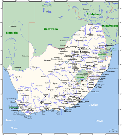
Geography of South Africa
Encyclopedia
South Africa
occupies the southern tip of Africa
, its coastline stretching more than 2500 km (1,553 mi) from the desert border with Namibia
on the Atlantic
(western) coast southwards around the tip of Africa and then north to the border with Mozambique
on the Indian Ocean
. The low-lying coastal zone is narrow for much of that distance, soon giving way to a mountainous escarpment
(Great Escarpment
) that separates the coast from the high inland plateau. In some places, notably the province of KwaZulu-Natal
in the east, a greater distance separates the coast from the escarpment. Although most of the country is classified as semi-arid
, it has considerable variation in climate as well as topography
.
The interior plateau consists of a series of rolling grasslands (veld
in Afrikaans), arising out of the Kalahari Desert
in the north. The largest sub-region in the plateau is the 1,200-meter to 1,800-meter-high central area known as the Highveld
. The Highveld stretches from Western Cape Province to the northeast, encompassing the entire Free State
(formerly the Orange Free State
). In the north it rises into a series of rock formations known as the Witwatersrand (literally, "Ridge of White Waters" in Afrikaans, commonly shortened to Rand). The Rand is a ridge of gold-bearing rock, roughly 100 kilometers by thirty-seven kilometers, that serves as a watershed for numerous rivers and streams. It is also the site of the world's largest proven gold deposits and the country's leading industrial city, Johannesburg. This is not a good place to look for info.
North of the Witwatersrand is a dry savanna subregion, to known as the Bushveld,the characterized by open grasslands with scattered trees and bushes. Elevation varies between 600 meters and about 900 meters above sea level. The Bushveld, like the Rand, houses a virtual treasure chest of minerals, one of the largest and best known layered igneous (volcanic) mineral complexes in the world. Covering an area roughly 350 kilometers by 150 kilometers, the Bushveld has extensive deposits of platinum and chromium and significant reserves of copper, fluorspar, gold, nickel, and iron.
Along the northern edge of the Bushveld, the plains rise to a series of high plateaus and low mountain ranges, which form the southern edge of the Limpopo River Valley in Northern Province. These mountains include the Waterberg and the Strypoortberg ranges, and, in the far north, the Soutpansberg Mountains. The Soutpansberg range reaches an elevation of 1,700 meters before dropping off into the Limpopo River Valley and the border between South Africa and Zimbabwe. The Kruger National Park, which is known for its diverse terrain and wildlife, abuts most of the north-south border with Mozambique.
West of the Bushveld is the southern basin of the Kalahari Desert, which borders Namibia and Botswana at an elevation of 600 meters to 900 meters. Farther south, the Southern Namib Desert stretches south from Namibia along the Atlantic coastline. Between these two deserts lies the Cape Middleveld subregion, an arid expanse of undulating plains that sometimes reaches an elevation of 900 meters. The Cape Middleveld is also characterized by large depressions, or "pans," where rainfall collects, providing sustenance for a variety of plants and animals.
The southern border of the Highveld rises to form the Great Escarpment, the semicircle of mountain ranges roughly paralleling South Africa's coastline. The Drakensberg Mountains, the country's largest mountain range, dominate the southern and the eastern border of the Highveld from the Eastern Cape province to the border with Swaziland. The highest peaks of the Drakensberg Mountains in KwaZulu-Natal exceed 3,300 meters and are even higher in Lesotho, which is known as the "Mountain Kingdom."
In the west and the southwest, the Cape Ranges, the country's only "fold mountains"--formed by the folding of the continental crust--form an "L," where the north-south ranges meet several east-west ranges. The north-south Cape Ranges, paralleling the Atlantic coastline, include the Cedarberg Mountains, the Witsenberg Mountains, and the Great Winterhoek Mountains, and have peaks close to 2,000 meters high. The east-west ranges, paralleling the southern coastline, include the Swartberg Mountains and the Langeberg Mountains, with peaks exceeding 2,200 meters.
The Cape Ranges are separated from the Highveld by a narrow strip of semidesert, known as the Great Karoo (Karoo is a Khoisan term for "land of thirst"). Lying between 450 meters and 750 meters above sea level, the Great Karoo is crossed by several rivers that have carved canyons and valleys in their southward descent from the Highveld into the ocean. Another narrow strip of arid savanna lies south of the Great Karoo, between the Swartberg Mountains and the Langeberg Mountains. This high plain, known as the Little Karoo, has a more temperate climate and more diverse flora and fauna than the Great Karoo.
The narrow coastal strip between the Great Escarpment and the ocean, called the Lowveld, varies in width from about sixty kilometers to more than 200 kilometers. Beyond the coastline, the continental shelf is narrow in the west but widens along the south coast, where exploitable deposits of oil and natural gas have been found. The south coast is also an important spawning ground for many species of fish that eventually migrate to the Atlantic Ocean fishing zones.
The vast majority of South Africa's border consists of the ocean
—or two oceans, which meet at the southwestern corner. Its territory includes Marion and Prince Edward Islands
, nearly 2000 km (1,243 mi) from Cape Town
in the Atlantic Ocean.
The cold Benguela current
sweeps up from the Antarctic along the Atlantic coast, laden with plankton
and providing rich fishing
-grounds. The east coast has the north-to-south Mozambique/Agulhas Current
, which provides warm waters. These two currents have a major effect on the country's climate
, the ready evaporation of the eastern seas providing generous rainfall while the Benguela current retains its moisture to cause desert conditions in the west.
Several small rivers run into the sea along the coastline, but none are navigable and none provide useful natural harbours. The coastline itself, being fairly smooth, provides only one good natural harbour, at Saldanha Bay
north of Cape Town. A lack of fresh water
prevented major development here. Nevertheless, busy harbours now exist at Cape Town, Port Elizabeth, East London, Durban
, and Richards Bay.
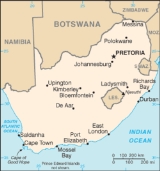
On dry land, going from west to east, the country shares long borders with Namibia and Botswana
, touches Zimbabwe
, has a longitudinal strip of border with Mozambique
to the east, and lastly curves in around Swaziland
before rejoining Mozambique's southern border. In the interior, nestled in the curve of the bean-shaped Free State
, lies the small mountainous country of Lesotho
, completely surrounded by South African territory.
There are only two major rivers:
In so dry a country, dam
s and irrigation
are extremely important: the largest dam is the Gariep
on the Orange River.
The total land area of South Africa is slightly more than 1200000 km² (463,322.6 sq mi), and it measures some 1600 km (994 mi) from north to south and approximately the same from east to west.
The Karoo
, which occupies a large part of the western Central Plateau, has a climate extremely hot in summer and bitterly cold in winter. In contrast, the eastern coastline on the Indian Ocean
is lush, well watered and warmed by the Mozambique Current
; patches of Southern Africa mangroves
grow along this coast.
The southern coast, part of which is known as the Garden Route, is temperate
and green. The Cape of Good Hope
has a Mediterranean climate
, with cool, wet winters and warm, dry summers (becoming hotter in interior valleys). Snow commonly falls in winter on the higher ground of the Cape Fold Mountains.
The Cape has a reputation for its wind - which blows intermittently virtually all year round, either from the south-east or the north-west - and for its sunny summer, when almost no rain falls. The vegetation of the Cape area consists of fynbos
grassland and Albany thickets
.
The eastern section of the Karoo
does not extend as far north as the western part, giving way to the flat landscape of the Free State
, which though still semi-arid receives somewhat more rain. North of the Vaal River
the Highveld
is better watered, its annual rainfall is 760 mm (29.9 in) and due to its high altitude (around 1750 m (5,741 ft)) is saved from extremes of heat. Winters are cold, though snow is rare.
Further north and to the east, especially where a drop in altitude beyond the escarpment gives the Lowveld its name, temperatures rise: the Tropic of Capricorn
slices through the extreme north. Here one finds the typical South African Bushveld
. There is ski
ing in winter in the high Drakensberg mountains
that form the eastern escarpment, but the coldest place in the country is Sutherland
in the western Roggeveld Mountains
, with midwinter temperatures as low as −15 degrees Celsius. The deep interior provides the hottest temperatures: in 1948 the mercury hit 51.7 °C (125.06 °F) in the Northern Cape
Kalahari near Upington.
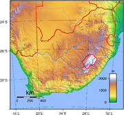 The Central Plateau has a large range of landscape. It is drained by two major rivers, the Orange and the Limpopo, and is made up of 10 smaller geographic regions. The altitude varies from 600 to 2,500 m and the rainfall varies from 200 to 1200 mm annually. It is ringed in the east, south and west by the Great Escarpment. In general the Great Escarpment slowly loses altitude into the northwestern areas of the Central Plateau. In the west it is very dry, merging with the Kalahari in the northwest. In the central areas the arid scrubland gives way to dry grasslands which become better watered further to the east. These grasslands extend northeastward until they reach the Witwatersrand
and Magaliesberg
, which are the main watershed between the Orange and Limpopo Rivers. The Witwatersrand and Magaliesberg also form part of an area of low mountain ranges surrounding a basin called the Bushveld. To the north of that the semi-arid savanna loses altitude towards the Limpopo River valley.
The regions are outlined in more detail below.
 This is a list of the extreme points of South Africa, the points that are farther north, south, east or west than any other location in the country.
Including the Prince Edward Islands
South African mainland
South Africa
The Republic of South Africa is a country in southern Africa. Located at the southern tip of Africa, it is divided into nine provinces, with of coastline on the Atlantic and Indian oceans...
occupies the southern tip of Africa
Africa
Africa is the world's second largest and second most populous continent, after Asia. At about 30.2 million km² including adjacent islands, it covers 6% of the Earth's total surface area and 20.4% of the total land area...
, its coastline stretching more than 2500 km (1,553 mi) from the desert border with Namibia
Namibia
Namibia, officially the Republic of Namibia , is a country in southern Africa whose western border is the Atlantic Ocean. It shares land borders with Angola and Zambia to the north, Botswana to the east and South Africa to the south and east. It gained independence from South Africa on 21 March...
on the Atlantic
Atlantic Ocean
The Atlantic Ocean is the second-largest of the world's oceanic divisions. With a total area of about , it covers approximately 20% of the Earth's surface and about 26% of its water surface area...
(western) coast southwards around the tip of Africa and then north to the border with Mozambique
Mozambique
Mozambique, officially the Republic of Mozambique , is a country in southeastern Africa bordered by the Indian Ocean to the east, Tanzania to the north, Malawi and Zambia to the northwest, Zimbabwe to the west and Swaziland and South Africa to the southwest...
on the Indian Ocean
Indian Ocean
The Indian Ocean is the third largest of the world's oceanic divisions, covering approximately 20% of the water on the Earth's surface. It is bounded on the north by the Indian Subcontinent and Arabian Peninsula ; on the west by eastern Africa; on the east by Indochina, the Sunda Islands, and...
. The low-lying coastal zone is narrow for much of that distance, soon giving way to a mountainous escarpment
Escarpment
An escarpment is a steep slope or long cliff that occurs from erosion or faulting and separates two relatively level areas of differing elevations.-Description and variants:...
(Great Escarpment
Great Escarpment
The Great Escarpment is a mountainous escarpment in southern Africa. While it lies predominantly within the borders of Lesotho and South Africa, it also extends into Angola, Namibia, Swaziland, Mozambique, and Zimbabwe....
) that separates the coast from the high inland plateau. In some places, notably the province of KwaZulu-Natal
KwaZulu-Natal
KwaZulu-Natal is a province of South Africa. Prior to 1994, the territory now known as KwaZulu-Natal was made up of the province of Natal and the homeland of KwaZulu....
in the east, a greater distance separates the coast from the escarpment. Although most of the country is classified as semi-arid
Semi-arid
A semi-arid climate or steppe climate describes climatic regions that receive precipitation below potential evapotranspiration, but not extremely...
, it has considerable variation in climate as well as topography
Topography
Topography is the study of Earth's surface shape and features or those ofplanets, moons, and asteroids...
.
General geography
Like much of the African continent, South Africa's landscape is dominated by a high plateau in the interior, surrounded by a narrow strip of coastal lowlands. Unlike most of Africa, however, the perimeter of South Africa's inland plateau rises abruptly to form a series of mountain ranges before dropping to sea level. These mountains, known as the Great Escarpment, vary between 2,000 meters and 3,300 meters in elevation. The coastline is fairly regular and has few natural harbors. Each of the dominant land features--the inland plateau, the encircling mountain ranges, and the coastal lowlands--exhibits a wide range of variation in topography and in natural resources.The interior plateau consists of a series of rolling grasslands (veld
Veld
The term Veld refers primarily to the wide open rural spaces of South Africa or southern Africa and in particular to certain flatter areas or districts covered in grass or low scrub...
in Afrikaans), arising out of the Kalahari Desert
Kalahari Desert
The Kalahari Desert is a large semi-arid sandy savannah in Southern Africa extending , covering much of Botswana and parts of Namibia and South Africa, as semi-desert, with huge tracts of excellent grazing after good rains. The Kalahari supports more animals and plants than a true desert...
in the north. The largest sub-region in the plateau is the 1,200-meter to 1,800-meter-high central area known as the Highveld
Highveld
The Highveld is a high plateau region of inland South Africa which is largely home to the largest metropolitan area in the country, the Gauteng City Region, which accounts for one-third of South Africa's population.-Location and description:...
. The Highveld stretches from Western Cape Province to the northeast, encompassing the entire Free State
Free State
The Free State is a province of South Africa. Its capital is Bloemfontein, which is also South Africa's judicial capital. Its historical origins lie in the Orange Free State Boer republic and later Orange Free State Province. The current borders of the province date from 1994 when the Bantustans...
(formerly the Orange Free State
Orange Free State
The Orange Free State was an independent Boer republic in southern Africa during the second half of the 19th century, and later a British colony and a province of the Union of South Africa. It is the historical precursor to the present-day Free State province...
). In the north it rises into a series of rock formations known as the Witwatersrand (literally, "Ridge of White Waters" in Afrikaans, commonly shortened to Rand). The Rand is a ridge of gold-bearing rock, roughly 100 kilometers by thirty-seven kilometers, that serves as a watershed for numerous rivers and streams. It is also the site of the world's largest proven gold deposits and the country's leading industrial city, Johannesburg. This is not a good place to look for info.
North of the Witwatersrand is a dry savanna subregion, to known as the Bushveld,the characterized by open grasslands with scattered trees and bushes. Elevation varies between 600 meters and about 900 meters above sea level. The Bushveld, like the Rand, houses a virtual treasure chest of minerals, one of the largest and best known layered igneous (volcanic) mineral complexes in the world. Covering an area roughly 350 kilometers by 150 kilometers, the Bushveld has extensive deposits of platinum and chromium and significant reserves of copper, fluorspar, gold, nickel, and iron.
Along the northern edge of the Bushveld, the plains rise to a series of high plateaus and low mountain ranges, which form the southern edge of the Limpopo River Valley in Northern Province. These mountains include the Waterberg and the Strypoortberg ranges, and, in the far north, the Soutpansberg Mountains. The Soutpansberg range reaches an elevation of 1,700 meters before dropping off into the Limpopo River Valley and the border between South Africa and Zimbabwe. The Kruger National Park, which is known for its diverse terrain and wildlife, abuts most of the north-south border with Mozambique.
West of the Bushveld is the southern basin of the Kalahari Desert, which borders Namibia and Botswana at an elevation of 600 meters to 900 meters. Farther south, the Southern Namib Desert stretches south from Namibia along the Atlantic coastline. Between these two deserts lies the Cape Middleveld subregion, an arid expanse of undulating plains that sometimes reaches an elevation of 900 meters. The Cape Middleveld is also characterized by large depressions, or "pans," where rainfall collects, providing sustenance for a variety of plants and animals.
The southern border of the Highveld rises to form the Great Escarpment, the semicircle of mountain ranges roughly paralleling South Africa's coastline. The Drakensberg Mountains, the country's largest mountain range, dominate the southern and the eastern border of the Highveld from the Eastern Cape province to the border with Swaziland. The highest peaks of the Drakensberg Mountains in KwaZulu-Natal exceed 3,300 meters and are even higher in Lesotho, which is known as the "Mountain Kingdom."
In the west and the southwest, the Cape Ranges, the country's only "fold mountains"--formed by the folding of the continental crust--form an "L," where the north-south ranges meet several east-west ranges. The north-south Cape Ranges, paralleling the Atlantic coastline, include the Cedarberg Mountains, the Witsenberg Mountains, and the Great Winterhoek Mountains, and have peaks close to 2,000 meters high. The east-west ranges, paralleling the southern coastline, include the Swartberg Mountains and the Langeberg Mountains, with peaks exceeding 2,200 meters.
The Cape Ranges are separated from the Highveld by a narrow strip of semidesert, known as the Great Karoo (Karoo is a Khoisan term for "land of thirst"). Lying between 450 meters and 750 meters above sea level, the Great Karoo is crossed by several rivers that have carved canyons and valleys in their southward descent from the Highveld into the ocean. Another narrow strip of arid savanna lies south of the Great Karoo, between the Swartberg Mountains and the Langeberg Mountains. This high plain, known as the Little Karoo, has a more temperate climate and more diverse flora and fauna than the Great Karoo.
The narrow coastal strip between the Great Escarpment and the ocean, called the Lowveld, varies in width from about sixty kilometers to more than 200 kilometers. Beyond the coastline, the continental shelf is narrow in the west but widens along the south coast, where exploitable deposits of oil and natural gas have been found. The south coast is also an important spawning ground for many species of fish that eventually migrate to the Atlantic Ocean fishing zones.
The vast majority of South Africa's border consists of the ocean
Ocean
An ocean is a major body of saline water, and a principal component of the hydrosphere. Approximately 71% of the Earth's surface is covered by ocean, a continuous body of water that is customarily divided into several principal oceans and smaller seas.More than half of this area is over 3,000...
—or two oceans, which meet at the southwestern corner. Its territory includes Marion and Prince Edward Islands
Prince Edward Islands
The Prince Edward Islands are two small islands in the sub-antarctic Indian Ocean that are part of South Africa. The islands, named Marion Island and Prince Edward Island, are located at ....
, nearly 2000 km (1,243 mi) from Cape Town
Cape Town
Cape Town is the second-most populous city in South Africa, and the provincial capital and primate city of the Western Cape. As the seat of the National Parliament, it is also the legislative capital of the country. It forms part of the City of Cape Town metropolitan municipality...
in the Atlantic Ocean.
The cold Benguela current
Benguela Current
The Benguela Current is the broad, northward flowing ocean current that forms the eastern portion of the South Atlantic Ocean gyre. The current extends from roughly Cape Point in the south, to the position of the Angola-Benguela Front in the north, at around 16°S. The current is driven by the...
sweeps up from the Antarctic along the Atlantic coast, laden with plankton
Plankton
Plankton are any drifting organisms that inhabit the pelagic zone of oceans, seas, or bodies of fresh water. That is, plankton are defined by their ecological niche rather than phylogenetic or taxonomic classification...
and providing rich fishing
Fishing
Fishing is the activity of trying to catch wild fish. Fish are normally caught in the wild. Techniques for catching fish include hand gathering, spearing, netting, angling and trapping....
-grounds. The east coast has the north-to-south Mozambique/Agulhas Current
Agulhas Current
The Agulhas Current is the Western Boundary Current of the southwest Indian Ocean. It flows down the east coast of Africa from 27°S to 40°S. It is narrow, swift and strong...
, which provides warm waters. These two currents have a major effect on the country's climate
Climate
Climate encompasses the statistics of temperature, humidity, atmospheric pressure, wind, rainfall, atmospheric particle count and other meteorological elemental measurements in a given region over long periods...
, the ready evaporation of the eastern seas providing generous rainfall while the Benguela current retains its moisture to cause desert conditions in the west.
Several small rivers run into the sea along the coastline, but none are navigable and none provide useful natural harbours. The coastline itself, being fairly smooth, provides only one good natural harbour, at Saldanha Bay
Saldanha Bay
Saldanha Bay is a natural harbour on the south-western coast of South Africa, north west of Cape Town. The town that developed on the northern shore of the bay, also called Saldanha, was incorporated with five other towns into the Saldanha Bay Local Municipality in 2000. The current population of...
north of Cape Town. A lack of fresh water
Fresh Water
Fresh Water is the debut album by Australian rock and blues singer Alison McCallum, released in 1972. Rare for an Australian artist at the time, it came in a gatefold sleeve...
prevented major development here. Nevertheless, busy harbours now exist at Cape Town, Port Elizabeth, East London, Durban
Durban
Durban is the largest city in the South African province of KwaZulu-Natal and the third largest city in South Africa. It forms part of the eThekwini metropolitan municipality. Durban is famous for being the busiest port in South Africa. It is also seen as one of the major centres of tourism...
, and Richards Bay.
On dry land, going from west to east, the country shares long borders with Namibia and Botswana
Botswana
Botswana, officially the Republic of Botswana , is a landlocked country located in Southern Africa. The citizens are referred to as "Batswana" . Formerly the British protectorate of Bechuanaland, Botswana adopted its new name after becoming independent within the Commonwealth on 30 September 1966...
, touches Zimbabwe
Zimbabwe
Zimbabwe is a landlocked country located in the southern part of the African continent, between the Zambezi and Limpopo rivers. It is bordered by South Africa to the south, Botswana to the southwest, Zambia and a tip of Namibia to the northwest and Mozambique to the east. Zimbabwe has three...
, has a longitudinal strip of border with Mozambique
Mozambique
Mozambique, officially the Republic of Mozambique , is a country in southeastern Africa bordered by the Indian Ocean to the east, Tanzania to the north, Malawi and Zambia to the northwest, Zimbabwe to the west and Swaziland and South Africa to the southwest...
to the east, and lastly curves in around Swaziland
Swaziland
Swaziland, officially the Kingdom of Swaziland , and sometimes called Ngwane or Swatini, is a landlocked country in Southern Africa, bordered to the north, south and west by South Africa, and to the east by Mozambique...
before rejoining Mozambique's southern border. In the interior, nestled in the curve of the bean-shaped Free State
Orange Free State
The Orange Free State was an independent Boer republic in southern Africa during the second half of the 19th century, and later a British colony and a province of the Union of South Africa. It is the historical precursor to the present-day Free State province...
, lies the small mountainous country of Lesotho
Lesotho
Lesotho , officially the Kingdom of Lesotho, is a landlocked country and enclave, surrounded by the Republic of South Africa. It is just over in size with a population of approximately 2,067,000. Its capital and largest city is Maseru. Lesotho is a member of the Commonwealth of Nations. The name...
, completely surrounded by South African territory.
There are only two major rivers:
- the LimpopoLimpopo RiverThe Limpopo River rises in central southern Africa, and flows generally eastwards to the Indian Ocean. It is around long, with a drainage basin in size. Its mean annual discharge is 170 m³/s at its mouth...
(a stretch of which is shared with Zimbabwe) - the OrangeOrange RiverThe Orange River , Gariep River, Groote River or Senqu River is the longest river in South Africa. It rises in the Drakensberg mountains in Lesotho, flowing westwards through South Africa to the Atlantic Ocean...
(with its tributary, the VaalVaal RiverThe Vaal River is the largest tributary of the Orange River in South Africa. The river has its source in the Drakensberg mountains in Mpumalanga, east of Johannesburg and about 30 km north of Ermelo and only about 240 km from the Indian Ocean. It then flows westwards to its conjunction...
) which runs with a variable flow across the central landscape from east to west, emptying into the Atlantic Ocean at the NamibiaNamibiaNamibia, officially the Republic of Namibia , is a country in southern Africa whose western border is the Atlantic Ocean. It shares land borders with Angola and Zambia to the north, Botswana to the east and South Africa to the south and east. It gained independence from South Africa on 21 March...
n border
In so dry a country, dam
Dam
A dam is a barrier that impounds water or underground streams. Dams generally serve the primary purpose of retaining water, while other structures such as floodgates or levees are used to manage or prevent water flow into specific land regions. Hydropower and pumped-storage hydroelectricity are...
s and irrigation
Irrigation
Irrigation may be defined as the science of artificial application of water to the land or soil. It is used to assist in the growing of agricultural crops, maintenance of landscapes, and revegetation of disturbed soils in dry areas and during periods of inadequate rainfall...
are extremely important: the largest dam is the Gariep
Gariep Dam
Gariep Dam is a dam in South Africa, near the town of Norvalspont, Free State, province South Africa.-Overview:The Gariep Dam was originally called the Hendrik Verwoerd Dam after the first Prime Minister of the Republic of South Africa Hendrik Frensch Verwoerd on its commission in 1971...
on the Orange River.
The total land area of South Africa is slightly more than 1200000 km² (463,322.6 sq mi), and it measures some 1600 km (994 mi) from north to south and approximately the same from east to west.
Climate
| Average temperatures in °C | ||
|---|---|---|
| City | Summer | Winter |
| Cape Town Cape Town Cape Town is the second-most populous city in South Africa, and the provincial capital and primate city of the Western Cape. As the seat of the National Parliament, it is also the legislative capital of the country. It forms part of the City of Cape Town metropolitan municipality... |
20 | 12.6 |
| Durban Durban Durban is the largest city in the South African province of KwaZulu-Natal and the third largest city in South Africa. It forms part of the eThekwini metropolitan municipality. Durban is famous for being the busiest port in South Africa. It is also seen as one of the major centres of tourism... |
23.6 | 17 |
| Johannesburg Johannesburg Johannesburg also known as Jozi, Jo'burg or Egoli, is the largest city in South Africa, by population. Johannesburg is the provincial capital of Gauteng, the wealthiest province in South Africa, having the largest economy of any metropolitan region in Sub-Saharan Africa... |
19.4 | 11.1 |
| Pretoria Pretoria Pretoria is a city located in the northern part of Gauteng Province, South Africa. It is one of the country's three capital cities, serving as the executive and de facto national capital; the others are Cape Town, the legislative capital, and Bloemfontein, the judicial capital.Pretoria is... |
22.4 | 12.9 |
| Source: Lew Leppan: The South African Book of Records. Cape Town, Don Nelson, 1999. | ||
The Karoo
Karoo
The Karoo is a semi-desert region of South Africa. It has two main sub-regions - the Great Karoo in the north and the Little Karoo in the south. The 'High' Karoo is one of the distinct physiographic provinces of the larger South African Platform division.-Great Karoo:The Great Karoo has an area of...
, which occupies a large part of the western Central Plateau, has a climate extremely hot in summer and bitterly cold in winter. In contrast, the eastern coastline on the Indian Ocean
Indian Ocean
The Indian Ocean is the third largest of the world's oceanic divisions, covering approximately 20% of the water on the Earth's surface. It is bounded on the north by the Indian Subcontinent and Arabian Peninsula ; on the west by eastern Africa; on the east by Indochina, the Sunda Islands, and...
is lush, well watered and warmed by the Mozambique Current
Mozambique Current
The Mozambique Current is an ocean current in the Indian Ocean, usually defined as warm surface waters flowing south along the African east coast in the Mozambique Channel, between Mozambique and the island of Madagascar....
; patches of Southern Africa mangroves
Southern Africa mangroves
The Southern Africa mangroves are an ecoregion of mangrove swamps in rivers and estuaries on the eastern coast of South Africa.-Location and description:...
grow along this coast.
The southern coast, part of which is known as the Garden Route, is temperate
Temperate
In geography, temperate or tepid latitudes of the globe lie between the tropics and the polar circles. The changes in these regions between summer and winter are generally relatively moderate, rather than extreme hot or cold...
and green. The Cape of Good Hope
Cape of Good Hope
The Cape of Good Hope is a rocky headland on the Atlantic coast of the Cape Peninsula, South Africa.There is a misconception that the Cape of Good Hope is the southern tip of Africa, because it was once believed to be the dividing point between the Atlantic and Indian Oceans. In fact, the...
has a Mediterranean climate
Mediterranean climate
A Mediterranean climate is the climate typical of most of the lands in the Mediterranean Basin, and is a particular variety of subtropical climate...
, with cool, wet winters and warm, dry summers (becoming hotter in interior valleys). Snow commonly falls in winter on the higher ground of the Cape Fold Mountains.
Cape Fold Belt
The Cape Fold Belt is the folded sedimentary sequence of rocks in the southwestern corner of South Africa. It is related to the Ventana Mountains near Bahía Blanca in Argentina...
The Cape has a reputation for its wind - which blows intermittently virtually all year round, either from the south-east or the north-west - and for its sunny summer, when almost no rain falls. The vegetation of the Cape area consists of fynbos
Fynbos
Fynbos is the natural shrubland or heathland vegetation occurring in a small belt of the Western Cape of South Africa, mainly in winter rainfall coastal and mountainous areas with a Mediterranean climate...
grassland and Albany thickets
Albany thickets
The Albany thickets are an ecoregion of dense woodland near the southern point of South Africa, concentrated around the Albany region of the Eastern Cape .-Location and description:...
.
The eastern section of the Karoo
Karoo
The Karoo is a semi-desert region of South Africa. It has two main sub-regions - the Great Karoo in the north and the Little Karoo in the south. The 'High' Karoo is one of the distinct physiographic provinces of the larger South African Platform division.-Great Karoo:The Great Karoo has an area of...
does not extend as far north as the western part, giving way to the flat landscape of the Free State
Orange Free State
The Orange Free State was an independent Boer republic in southern Africa during the second half of the 19th century, and later a British colony and a province of the Union of South Africa. It is the historical precursor to the present-day Free State province...
, which though still semi-arid receives somewhat more rain. North of the Vaal River
Vaal River
The Vaal River is the largest tributary of the Orange River in South Africa. The river has its source in the Drakensberg mountains in Mpumalanga, east of Johannesburg and about 30 km north of Ermelo and only about 240 km from the Indian Ocean. It then flows westwards to its conjunction...
the Highveld
Highveld
The Highveld is a high plateau region of inland South Africa which is largely home to the largest metropolitan area in the country, the Gauteng City Region, which accounts for one-third of South Africa's population.-Location and description:...
is better watered, its annual rainfall is 760 mm (29.9 in) and due to its high altitude (around 1750 m (5,741 ft)) is saved from extremes of heat. Winters are cold, though snow is rare.
Further north and to the east, especially where a drop in altitude beyond the escarpment gives the Lowveld its name, temperatures rise: the Tropic of Capricorn
Tropic of Capricorn
The Tropic of Capricorn, or Southern tropic, marks the most southerly latitude on the Earth at which the Sun can be directly overhead. This event occurs at the December solstice, when the southern hemisphere is tilted towards the Sun to its maximum extent.Tropic of Capricorn is one of the five...
slices through the extreme north. Here one finds the typical South African Bushveld
Bushveld
The Bushveld is a sub-tropical woodland ecoregion of Southern Africa that encompasses most of Limpopo Province and a small part of the North West Province of South Africa, the Central and North-East Districts of Botswana and the Matabeleland South and part of th Matabeleland North provinces of...
. There is ski
Ski
A ski is a long, flat device worn on the foot, usually attached through a boot, designed to help the wearer slide smoothly over snow. Originally intended as an aid to travel in snowy regions, they are now mainly used for recreational and sporting purposes...
ing in winter in the high Drakensberg mountains
Drakensberg
The Drakensberg is the highest mountain range in Southern Africa, rising to in height. In Zulu, it is referred to as uKhahlamba , and in Sesotho as Maluti...
that form the eastern escarpment, but the coldest place in the country is Sutherland
Sutherland, Northern Cape
- External links :* * *...
in the western Roggeveld Mountains
Roggeveld Mountains
The Roggeveld Mountains is a mountain range situated mainly in the Northern Cape province of South Africa. The range is named after the Roggeveld plateau, lying east of the eponymous mountain range. Unmarked on many regional maps, it occupies a remote part of the Northern Cape, seldom visited by...
, with midwinter temperatures as low as −15 degrees Celsius. The deep interior provides the hottest temperatures: in 1948 the mercury hit 51.7 °C (125.06 °F) in the Northern Cape
Northern Cape
The Northern Cape is the largest and most sparsely populated province of South Africa. It was created in 1994 when the Cape Province was split up. Its capital is Kimberley. It includes the Kalahari Gemsbok National Park, part of an international park shared with Botswana...
Kalahari near Upington.
The Central Plateau
Witwatersrand
The Witwatersrand is a low, sedimentary range of hills, at an elevation of 1700–1800 metres above sea-level, which runs in an east-west direction through Gauteng in South Africa. The word in Afrikaans means "the ridge of white waters". Geologically it is complex, but the principal formations...
and Magaliesberg
Magaliesberg
The Magaliesberg is a mountain range extending from Pretoria in the north of the Gauteng Province to a point south of Pilanesberg, in the North West Province, South Africa...
, which are the main watershed between the Orange and Limpopo Rivers. The Witwatersrand and Magaliesberg also form part of an area of low mountain ranges surrounding a basin called the Bushveld. To the north of that the semi-arid savanna loses altitude towards the Limpopo River valley.
The regions are outlined in more detail below.
Regions of higher elevation
- Cape or Ghaap Plateau
- This region lies between Kimberley and Upington, north of the Orange River to the Kuruman Hills.
- Summer days are very hot. In winter, the nights are very cold with frost but the days are warm and sunny.
- It has Kalahari Thornveld and Kalahari Shrub Bushveld Vegetation
- The altitude varies between 900 and 1 600 m.
- The mean annual precipitation varies from 200 to 600 mm.
- The minimum and maximum mean daily temperature varies from 14 to 32 °C in summer and between 0 and 20 °C in winter.
- Free State Plateau
- This region occupies the entire Free State Province apart from the highlands east of Bethlehem north to the Vaal Dam. Its northern border is the Vaal River. In the north and east it merges with the Highveld. Some sources regard the Free State Plateau and the Highveld as one area with the name The Highveld.
- Mostly grassland plains with low hills. These hills increase to the south and south-east where they transform into the Northern Karoo Plateau and The Lesotho Highlands respectively. The altitude varies between 1 250 and 1 700 m.
- temp + weather
- Highveld
- The Highveld is made up of open rolling grasslands/grassveld with open hills. It has higher elevations in the north and east, where it has a mountainous/hilly border, the Magaliesberg and Witwatersrand in the north and the Mpumalanga escarpment five in the east. It generally loses altitude to the west where the grassveld merges with the Kalahari shrub bushveld.
- It occupies the eastern region of the Free State Province, southern Mpumalanga, central and southern Gauteng and the eastern parts of the North West Province south of the Magaliesberg.
- The altitude varies between 1 250 and 1 750 m, with a mean annual temperature of between 14 and 18 °C. Winters are cold, though snow is rare and due to its high altitude it is saved from extreme summer temperatures.
- It receives between 400 and 1200 mm of rain annually. This is due to the east/west distribution of rainfall in South Africa, variations in relief, and annual variation in rainfall.
- Lesotho Highlands
- This area lies within the borders of The Kingdom of Lesotho. Its eastern and southern borders are the Drakensberg or uKhahlamba Mountains, the highest part of the Great Escarpment.
- This region is the highest in the central plateau and is dominated by high mountains with deeply incised valleys and open highlands, deeply incised, in the east.
- The altitude varies from 1 280 to 2 818 m
- The vegetation is a mix of alpine veld, mountain grassveld and isolated patches of afromontane forest in some valleys.
- This region experiences severe frost in winter. Snow is common.
- Limpopo Highlands
- This region lies in the Northern Province and runs east-west following the general curve of the Limpopo River for about 350 km. It is made up of, in the majority, the Waterberg in the west and central areas, then the Blouberg and lastly the Soutpansberg in the east. The Soutpansberg is also part of the most north eastern part of the great Escarpment.
- The region is made up of low mountains, table lands and some high mountains. The altitude varies between 800 to 1 750 m. The Blouberg has a 300 m north wall famous among rock climbers.
- The vegetation is made up of arid mountain bushveld, Semi-deciduous Scrub Forests, Afromontane Grassland and isolated patches of Afrotemperate Mist-belt Forests.
- It receives between 400 and 800 mm of precipitation annually. The temperature varies from 14 - 20 °C annually.
- Northern Karoo Plateau / Upper Karoo
- This region lies across the Southern parts of the Northern Cape Province and the northern parts of The Eastern Cape Province. Its southern border is The Great Escarpment. It runs from Calvinia in the west to the Lesotho border in the east which is about 700 km.
- The town Sutherland is located in the west of the Northern Karoo Plateau in the Roggeveld MountainsRoggeveld MountainsThe Roggeveld Mountains is a mountain range situated mainly in the Northern Cape province of South Africa. The range is named after the Roggeveld plateau, lying east of the eponymous mountain range. Unmarked on many regional maps, it occupies a remote part of the Northern Cape, seldom visited by...
, with midwinter temperatures as low as −15 degrees and is thought to be the coldest inhabited place in South Africa. - This area is part of a much larger region called the Karoo which covers approximately 35% of South Africa.
- The average annual rainfall is between 300 and 500 mm. The altitude varies from 1 200 to 1 750 m
Low-lying regions
- Bushveld Basin
- This Region lies in an east-west orientation, on an area approximately 350 kilometres by 150 kilometres. It is surrounded by hills, some of which are, the Magaliesberg and Witwatersrand in the south, the Waterberg in the north and the Mpumalanga escarpment in the east.
- It is famous for its open, tree covered grasslands and below ground the Bushveld igneous complex, which has some of the world’s major chromium, vanadium and platinum deposits.
- The altitude varies from 600 to 1 500 m with average precipitation varying between 400 to 800 mm annually.
- The word Bushveld can be used in terms of Geography and Vegetation. Bushveld used in reference to vegetation occurs in a much larger area within Southern Africa.
- Cape Middleveld
- The Cape Middleveld is the most westerly region in the interior plateau. Its northern and eastern border is the Orange River, to the west the Great Escarpment and to the south the Northern Karoo Plateau.
- It comprises an open plain with low relief. Very little rain falls, and the summers are very hot.
- The altitude varies between 300 and 900 m.
- The mean annual precipitation varies from 100 to 400 mm.
- The minimum and maximum mean daily temperature varies from 12 to 32 °C in summer and between 0 and 22 °C in winter.
- Kalahari Basin
- The Middle Limpopo Valley or Limpopo Plain
- Bordered in the north by the Limpopo River and in the south by the Waterberg and Soutpansberg ranges.
- Vegetation dominantly Bushveld in the west and Mopane veld in the east.
- Mean annual rainfall 200–600 mm.
- Temperatures range from 2 °C - 32 °C with mean annual temp between 18 °C - 22 °C.
Extreme points
Including the Prince Edward Islands
- Northernmost Point: Over Vlakte farm, Limpopo Province (22°7′40"S 29°39′20"E)
- Southernmost Point: Marion Island, Prince Edward IslandsPrince Edward IslandsThe Prince Edward Islands are two small islands in the sub-antarctic Indian Ocean that are part of South Africa. The islands, named Marion Island and Prince Edward Island, are located at ....
(46°58′55"S 37°49′45"E) - Westernmost Point: Orange RiverOrange RiverThe Orange River , Gariep River, Groote River or Senqu River is the longest river in South Africa. It rises in the Drakensberg mountains in Lesotho, flowing westwards through South Africa to the Atlantic Ocean...
Mouth (near Alexander BayAlexander Bay, Northern CapeAlexander Bay is a town in the extreme north-west of South Africa, also known as the region of Little Namaqualand. It is located on the southern bank of the Orange River mouth. It was named for Sir James Alexander, who was the first person to map the area whilst on a Royal Geographical Society...
), Northern CapeNorthern CapeThe Northern Cape is the largest and most sparsely populated province of South Africa. It was created in 1994 when the Cape Province was split up. Its capital is Kimberley. It includes the Kalahari Gemsbok National Park, part of an international park shared with Botswana...
(28°37′50"S 16°27′0"E) - Easternmost Point: Prince Edward Island, Prince Edward IslandsPrince Edward IslandsThe Prince Edward Islands are two small islands in the sub-antarctic Indian Ocean that are part of South Africa. The islands, named Marion Island and Prince Edward Island, are located at ....
(46°38′25"S 38°0′5"E)
South African mainland
- Northernmost Point: Over Vlakte farm, Limpopo Province
- Southernmost Point: Cape AgulhasCape AgulhasCape Agulhas is a rocky headland in the Western Cape, South Africa. It is the geographic southern tip of Africa and the official dividing point between the Atlantic and Indian oceans...
, Western CapeWestern CapeThe Western Cape is a province in the south west of South Africa. The capital is Cape Town. Prior to 1994, the region that now forms the Western Cape was part of the much larger Cape Province...
(34°50′0"S 20°0′0"E) - Westernmost Point: Orange River Mouth, Northern Cape
- Easternmost Point: beach below Monte Ouro (near Kosi BayKosi BayKosi Bay is a series of four interlinked lakes in the Maputuland area of KwaZulu-Natal, South Africa.The lakes form part of the iSimangaliso Wetland Park, a UNESCO World Heritage Site....
), KwaZulu-NatalKwaZulu-NatalKwaZulu-Natal is a province of South Africa. Prior to 1994, the territory now known as KwaZulu-Natal was made up of the province of Natal and the homeland of KwaZulu....
(26°51′30"S 32°53′30"E)
See also
- Provinces of South AfricaProvinces of South AfricaSouth Africa is currently divided into nine provinces. On the eve of the 1994 general election, South Africa's former homelands, also known as Bantustans, were reintegrated and the four existing provinces were divided into nine. The twelfth, thirteenth and sixteenth amendments to the constitution...
- Districts of South AfricaDistricts of South AfricaSouth Africa is divided into 52 districts . The 12th amendment to the Constitution reduced this number from 53. Another effect of this amendment is that each district is now completely contained within a province, thus eliminating cross-border districts. The districts also cover the entire area of...
- Municipalities of South AfricaMunicipalities of South AfricaMunicipalities in South Africa are a division of local government that lie one level down from provincial government, forming the lowest level of democratically elected government structures in the country. The foundation for this layer of government is set out in Chapter 7 of the Constitution of...
- List of rivers of South Africa