
Districts of South Africa
Encyclopedia
South Africa
is divided into 52 districts (Metropolitan and District municipalities). The 12th amendment to the Constitution
(December 2005) reduced this number from 53. Another effect of this amendment is that each district is now completely contained within a province, thus eliminating cross-border districts. The districts also cover the entire area of the continental republic. South Africa's districts are analogous to counties
in Great Britain
and the United States
.
, which are divided into local municipalities
and share responsibilities with them. The eight largest urban agglomerations are governed by metropolitan municipalities
, which act as both local and district municipalities.
These include:
and municipalities
) and has called for them to be eliminated.
South Africa
The Republic of South Africa is a country in southern Africa. Located at the southern tip of Africa, it is divided into nine provinces, with of coastline on the Atlantic and Indian oceans...
is divided into 52 districts (Metropolitan and District municipalities). The 12th amendment to the Constitution
Constitution of South Africa
The Constitution of South Africa is the supreme law of the country of South Africa. It provides the legal foundation for the existence of the republic, sets out the rights and duties of its citizens, and defines the structure of the government. The current constitution, the country's fifth, was...
(December 2005) reduced this number from 53. Another effect of this amendment is that each district is now completely contained within a province, thus eliminating cross-border districts. The districts also cover the entire area of the continental republic. South Africa's districts are analogous to counties
County
A county is a jurisdiction of local government in certain modern nations. Historically in mainland Europe, the original French term, comté, and its equivalents in other languages denoted a jurisdiction under the sovereignty of a count A county is a jurisdiction of local government in certain...
in Great Britain
Great Britain
Great Britain or Britain is an island situated to the northwest of Continental Europe. It is the ninth largest island in the world, and the largest European island, as well as the largest of the British Isles...
and the United States
United States
The United States of America is a federal constitutional republic comprising fifty states and a federal district...
.
Types of district
There are two types of municipality at the district level. Most of the country is covered by the 44 district municipalitiesDistrict municipality (South Africa)
In South Africa, a district municipality or Category C municipality is a municipality which executes some of the functions of local government for a district. The district municipality will in turn comprise several local municipalities, with which it shares the functions of local government...
, which are divided into local municipalities
Local municipality (South Africa)
In South Africa, a local municipality or Category B municipality is a type of municipality that serves as the third, and most local, tier of local government...
and share responsibilities with them. The eight largest urban agglomerations are governed by metropolitan municipalities
Metropolitan municipality (South Africa)
In South Africa, a metropolitan municipality or Category A municipality is a municipality which executes all the functions of local government for a city or conurbation...
, which act as both local and district municipalities.
List
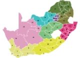
The following map depicts the provinces and districts of South Africa. The district municipalities are labelled with numbers that correspond to their district code, while the metropolitan municipalities are labelled with letters that correspond to their names. Further details of the districts are listed in the table that follows the image.| Name | Code | Province | Seat | Area (km²) | Population (2007) | Pop. density (per km²) |
|---|---|---|---|---|---|---|
| Alfred Nzo District Municipality Alfred Nzo District Municipality Alfred Nzo is one of the 7 districts of Eastern Cape province of South Africa. The seat of Alfred Nzo is Mount Ayliff. The majority of its 550 392 people speak Xhosa... |
Eastern Cape Eastern Cape The Eastern Cape is a province of South Africa. Its capital is Bhisho, but its two largest cities are Port Elizabeth and East London. It was formed in 1994 out of the "independent" Xhosa homelands of Transkei and Ciskei, together with the eastern portion of the Cape Province... |
Mount Ayliff Mount Ayliff Mount Ayliff is a small town in the eastern Eastern Cape province of South Africa, near that province's border with KwaZulu-Natal. In the census of 2001, its population was recorded as being 4,881 people, of whom 98% described themselves as "Black African", and 96% spoke Xhosa as their first... |
6,859 | 479,390 | 69.9 | |
| Amajuba District Municipality Amajuba District Municipality Amajuba is one of the 11 districts of KwaZulu-Natal province. The seat of Amajuba is Newcastle. The majority of its 468 040 people speak Zulu . The district code is DC25-Tourism:... |
KwaZulu-Natal KwaZulu-Natal KwaZulu-Natal is a province of South Africa. Prior to 1994, the territory now known as KwaZulu-Natal was made up of the province of Natal and the homeland of KwaZulu.... |
Newcastle Newcastle, KwaZulu-Natal Newcastle is the third largest city and urban center in KwaZulu-Natal, South Africa. Newcastle is located in the North West corner of the province along the Ncandu River and is moderately industrial.... |
6,911 | 442,266 | 64.0 | |
| Amathole District Municipality | Eastern Cape Eastern Cape The Eastern Cape is a province of South Africa. Its capital is Bhisho, but its two largest cities are Port Elizabeth and East London. It was formed in 1994 out of the "independent" Xhosa homelands of Transkei and Ciskei, together with the eastern portion of the Cape Province... |
East London | 21,043 | 940,441 | 44.7 | |
| Bojanala Platinum District Municipality Bojanala Platinum District Municipality Bojanala Platinum is one of the 4 districts of North West province of South Africa. The seat of Bojanala Platinum is Rustenburg. The majority of its 1 185 325 people speak Setswana... |
North West North West (South African province) North West is a province of South Africa. Its capital is Mafikeng. The province is located to the west of the major population centre of Gauteng.-History:... |
Rustenburg | 18,333 | 1,268,618 | 69.2 | |
| Buffalo City Metropolitan Municipality | BUF | Eastern Cape Eastern Cape The Eastern Cape is a province of South Africa. Its capital is Bhisho, but its two largest cities are Port Elizabeth and East London. It was formed in 1994 out of the "independent" Xhosa homelands of Transkei and Ciskei, together with the eastern portion of the Cape Province... |
East London | 2,536 | 724,312 | 285.6 |
| Cacadu District Municipality Cacadu District Municipality Cacadu District Municipality is situated in the Western Portion of the Eastern Cape province, covering an area of 58 242 square kilometres. The area of the district municipality includes nine local municipalities and other portions collectively known as the District Management Areas . The seat of... |
Eastern Cape Eastern Cape The Eastern Cape is a province of South Africa. Its capital is Bhisho, but its two largest cities are Port Elizabeth and East London. It was formed in 1994 out of the "independent" Xhosa homelands of Transkei and Ciskei, together with the eastern portion of the Cape Province... |
Port Elizabeth | 58,194 | 363,496 | 6.2 | |
| Cape Winelands District Municipality Cape Winelands District Municipality The Cape Winelands District Municipality, formerly the Boland District Municipality, is a district municipality located in the Western Cape province of South Africa. As of 2007, it had a population of 712,413... |
Western Cape Western Cape The Western Cape is a province in the south west of South Africa. The capital is Cape Town. Prior to 1994, the region that now forms the Western Cape was part of the much larger Cape Province... |
Worcester Worcester, Western Cape Worcester is a town in the Western Cape, South Africa. It is located 120 km north-east of Cape Town on the N1 highway north to Johannesburg.... |
22,309 | 712,413 | 31.9 | |
| Capricorn District Municipality Capricorn District Municipality Capricorn is one of the 6 districts of Limpopo province of South Africa. The district is named after the Tropic of Capricorn which runs through it. The seat of Capricorn is Polokwane. The majority of its 1 154 673 people speak Northern Sotho... |
Limpopo Limpopo Limpopo is the northernmost province of South Africa. The capital is Polokwane, formerly named Pietersburg. The province was formed from the northern region of Transvaal Province in 1994, and initially named Northern Transvaal... |
Polokwane Polokwane Polokwane, meaning "Place of Safety",is a city in the Polokwane Local Municipality and the capital of the Limpopo province, South Africa. It is also often referred to by its former name, Pietersburg. Polokwane is a major urban centre, the biggest and most important north of Gauteng. The population... |
16,988 | 1,243,167 | 73.2 | |
| Central Karoo District Municipality Central Karoo District Municipality The Central Karoo District Municipality is a district municipality located in the Western Cape Province of South Africa... |
Western Cape Western Cape The Western Cape is a province in the south west of South Africa. The capital is Cape Town. Prior to 1994, the region that now forms the Western Cape was part of the much larger Cape Province... |
Beaufort West Beaufort West Beaufort West is a town in the Western Cape province in South Africa. It is the largest town in the arid Great Karoo region, and forms part of the Beaufort West Local Municipality, with 37 000 inhabitants in 2001.... |
38,854 | 56,230 | 1.4 | |
| Chris Hani District Municipality Chris Hani District Municipality Chris Hani is one of the 7 districts of Eastern Cape province of South Africa. The seat of Chris Hani is Queenstown. The majority of its 810 274 people speak Xhosa , although Afrikaans speaking people predominate in the far west of the district... |
Eastern Cape Eastern Cape The Eastern Cape is a province of South Africa. Its capital is Bhisho, but its two largest cities are Port Elizabeth and East London. It was formed in 1994 out of the "independent" Xhosa homelands of Transkei and Ciskei, together with the eastern portion of the Cape Province... |
Queenstown Queenstown, Eastern Cape Queenstown, named after Queen Victoria, is a town in the middle of the Eastern Cape Province of South Africa, roughly half way in between the towns of Cathcart and Sterkstroom. It is currently the commercial, administrative, and educational centre of the prosperous surrounding farming district... |
36,695 | 798,597 | 21.8 | |
| City of Cape Town Metropolitan Municipality | CPT | Western Cape Western Cape The Western Cape is a province in the south west of South Africa. The capital is Cape Town. Prior to 1994, the region that now forms the Western Cape was part of the much larger Cape Province... |
Cape Town Cape Town Cape Town is the second-most populous city in South Africa, and the provincial capital and primate city of the Western Cape. As the seat of the National Parliament, it is also the legislative capital of the country. It forms part of the City of Cape Town metropolitan municipality... |
2,460 | 3,497,097 | 1,421.6 |
| City of Johannesburg Metropolitan Municipality City of Johannesburg Metropolitan Municipality The City of Johannesburg Metropolitan Municipality is a metropolitan municipality that manages the local governance of Johannesburg, South Africa... |
JHB | Gauteng Gauteng Gauteng is one of the nine provinces of South Africa. It was formed from part of the old Transvaal Province after South Africa's first all-race elections on 27 April 1994... |
Johannesburg Johannesburg Johannesburg also known as Jozi, Jo'burg or Egoli, is the largest city in South Africa, by population. Johannesburg is the provincial capital of Gauteng, the wealthiest province in South Africa, having the largest economy of any metropolitan region in Sub-Saharan Africa... |
1,645 | 3,888,180 | 2,363.6 |
| City of Tshwane Metropolitan Municipality | TSH | Gauteng Gauteng Gauteng is one of the nine provinces of South Africa. It was formed from part of the old Transvaal Province after South Africa's first all-race elections on 27 April 1994... |
Pretoria Pretoria Pretoria is a city located in the northern part of Gauteng Province, South Africa. It is one of the country's three capital cities, serving as the executive and de facto national capital; the others are Cape Town, the legislative capital, and Bloemfontein, the judicial capital.Pretoria is... |
6,345 | 2,499,447 | 393.9 |
| Dr Kenneth Kaunda District Municipality | North West North West (South African province) North West is a province of South Africa. Its capital is Mafikeng. The province is located to the west of the major population centre of Gauteng.-History:... |
Klerksdorp | 14,642 | 634,127 | 43.3 | |
| Dr Ruth Segomotsi Mompati District Municipality | North West North West (South African province) North West is a province of South Africa. Its capital is Mafikeng. The province is located to the west of the major population centre of Gauteng.-History:... |
Vryburg | 44,017 | 354,554 | 8.1 | |
| Eden District Municipality Eden District Municipality The Eden District Municipality is a district municipality located in the Western Cape Province of South Africa. Its municipality code is DC4.-Adjacent municipalities:* Central Karoo District Municipality... |
Western Cape Western Cape The Western Cape is a province in the south west of South Africa. The capital is Cape Town. Prior to 1994, the region that now forms the Western Cape was part of the much larger Cape Province... |
George George, Western Cape George is a city with 203,253 inhabitants in South Africa's Western Cape province. The city is a popular holiday and conference centre and the administrative and commercial hub of the Garden Route.- Location :... |
23,331 | 513,307 | 22.0 | |
| Ehlanzeni District Municipality Ehlanzeni District Municipality Ehlanzeni is one of the 3 districts of Mpumalanga province of South Africa. The seat of Ehlanzeni is Nelspruit. The majority of its 944 665 people speak SiSwati... |
Mpumalanga Mpumalanga Mpumalanga , is a province of South Africa. The name means east or literally "the place where the sun rises" in Swazi, Xhosa, Ndebele and Zulu. Mpumalanga lies in eastern South Africa, north of KwaZulu-Natal and bordering Swaziland and Mozambique. It constitutes 6.5% of South Africa's land area... |
Nelspruit Nelspruit Nelspruit is a city of more than 500,000 people situated in northeastern South Africa. It is the capital of the Mpumalanga province . Located on the Crocodile River, Nelspruit lies about west of the Mozambique border and east of Johannesburg. The towns of Nelspruit are Kanyamazane and Pienaar... |
27,896 | 1,526,236 | 54.7 | |
| Ekurhuleni Metropolitan Municipality | EKU | Gauteng Gauteng Gauteng is one of the nine provinces of South Africa. It was formed from part of the old Transvaal Province after South Africa's first all-race elections on 27 April 1994... |
Germiston | 1,924 | 2,724,229 | 1,415.9 |
| eThekwini Metropolitan Municipality | ETH | KwaZulu-Natal KwaZulu-Natal KwaZulu-Natal is a province of South Africa. Prior to 1994, the territory now known as KwaZulu-Natal was made up of the province of Natal and the homeland of KwaZulu.... |
Durban Durban Durban is the largest city in the South African province of KwaZulu-Natal and the third largest city in South Africa. It forms part of the eThekwini metropolitan municipality. Durban is famous for being the busiest port in South Africa. It is also seen as one of the major centres of tourism... |
2,292 | 3,468,086 | 1,513.1 |
| Fezile Dabi District Municipality Fezile Dabi District Municipality Fezile Dabi District Municipality, formerly known as Northern Free State District Municipality, is one of the 5 districts of Free State province of South Africa. The seat of Northern Free State is Sasolburg. The majority of its 460 289 people speak Sesotho... |
Free State Free State The Free State is a province of South Africa. Its capital is Bloemfontein, which is also South Africa's judicial capital. Its historical origins lie in the Orange Free State Boer republic and later Orange Free State Province. The current borders of the province date from 1994 when the Bantustans... |
Sasolburg Sasolburg Sasolburg is a large industrial town in the far north of the Free State province of South Africa. Sasolburg is further sub-divided into three areas: Sasolburg proper, Vaalpark and Zamdela... |
21,301 | 474,089 | 22.3 | |
| Frances Baard District Municipality Frances Baard District Municipality Frances Baard is one of the 5 districts of Northern Cape province of South Africa. The seat of Frances Baard is Kimberley. The majority of its 324 814 people speak Afrikaans . The district code is DC9.... |
Northern Cape Northern Cape The Northern Cape is the largest and most sparsely populated province of South Africa. It was created in 1994 when the Cape Province was split up. Its capital is Kimberley. It includes the Kalahari Gemsbok National Park, part of an international park shared with Botswana... |
Kimberley Kimberley, Northern Cape Kimberley is a city in South Africa, and the capital of the Northern Cape. It is located near the confluence of the Vaal and Orange Rivers. The town has considerable historical significance due its diamond mining past and siege during the Second Boer War... |
13,518 | 353,200 | 26.1 | |
| Gert Sibande District Municipality Gert Sibande District Municipality Gert Sibande is one of the 3 districts of Mpumalanga province of South Africa. The seat of Gert Sibande is Secunda. The majority of its 900 007 people speak IsiZulu . The district code is DC30... |
Mpumalanga Mpumalanga Mpumalanga , is a province of South Africa. The name means east or literally "the place where the sun rises" in Swazi, Xhosa, Ndebele and Zulu. Mpumalanga lies in eastern South Africa, north of KwaZulu-Natal and bordering Swaziland and Mozambique. It constitutes 6.5% of South Africa's land area... |
Secunda | 31,841 | 890,699 | 28.0 | |
| iLembe District Municipality ILembe District Municipality iLembe is one of the 11 district municipalities of KwaZulu-Natal province in South Africa. The seat of iLembe is KwaDukuza . The majority of its 560 409 people speak Zulu... |
KwaZulu-Natal KwaZulu-Natal KwaZulu-Natal is a province of South Africa. Prior to 1994, the territory now known as KwaZulu-Natal was made up of the province of Natal and the homeland of KwaZulu.... |
KwaDukuza | 3,269 | 528,198 | 161.6 | |
| John Taolo Gaetsewe District Municipality | Northern Cape Northern Cape The Northern Cape is the largest and most sparsely populated province of South Africa. It was created in 1994 when the Cape Province was split up. Its capital is Kimberley. It includes the Kalahari Gemsbok National Park, part of an international park shared with Botswana... |
Kuruman Kuruman Kuruman is a town with 12,701 inhabitants in Northern Cape province of South Africa, famous for its scenic beauty and the Eye of Kuruman, a geological feature bringing water from deep underground to the surface in the Kalahari Desert.... |
27,283 | 173,454 | 6.4 | |
| Lejweleputswa District Municipality Lejweleputswa District Municipality Lejweleputswa is one of the 5 districts of Free State province of South Africa. The seat of Lejweleputswa is Welkom. The majority of its 657 019 people speak Sotho... |
Free State Free State The Free State is a province of South Africa. Its capital is Bloemfontein, which is also South Africa's judicial capital. Its historical origins lie in the Orange Free State Boer republic and later Orange Free State Province. The current borders of the province date from 1994 when the Bantustans... |
Welkom Welkom Welkom is a city in the Free State province of South Africa, located 160 kilometres northeast of Bloemfontein, the provincial capital. Welkom received municipal status in 1961 and was declared a city in 1968 on the 14th of February... |
31,930 | 639,651 | 20.0 | |
| Mangaung Metropolitan Municipality Mangaung Metropolitan Municipality Mangaung Metropolitan Municipality is a metropolitan municipality which governs Bloemfontein and surrounding towns in the Free State province of South Africa. Mangaung is a Sesotho name meaning "place of leopards"... |
MAN | Free State Free State The Free State is a province of South Africa. Its capital is Bloemfontein, which is also South Africa's judicial capital. Its historical origins lie in the Orange Free State Boer republic and later Orange Free State Province. The current borders of the province date from 1994 when the Bantustans... |
Bloemfontein Bloemfontein Bloemfontein is the capital city of the Free State Province of South Africa; and, as the judicial capital of the nation, one of South Africa's three national capitals – the other two being Cape Town, the legislative capital, and Pretoria, the administrative capital.Bloemfontein is popularly and... |
6,284 | 752,906 | 119.8 |
| Mopani District Municipality Mopani District Municipality Mopani is one of the 6 districts of Limpopo province of South Africa. The seat of Mopani is Giyani. The majority of its 964 195 people speak Tsonga or Northern Sotho . The district code is DC33... |
Limpopo Limpopo Limpopo is the northernmost province of South Africa. The capital is Polokwane, formerly named Pietersburg. The province was formed from the northern region of Transvaal Province in 1994, and initially named Northern Transvaal... |
Giyani Giyani Giyani is a town in the Limpopo province in north eastern South Africa, and former capital of the Gazankulu bantustan. Giyani is located in the heart of Limpopo Bushveld, on the northern bank of the Klein Letaba River west of Kruger National Park... |
24,489 | 1,068,568 | 43.6 | |
| Namakwa District Municipality Namakwa District Municipality Namakwa is one of the 5 districts of the Northern Cape province of South Africa. The seat of Namakwa is Springbok and the region is also known as Little Namaqualand. The majority of its 108 118 people speak Afrikaans... |
Northern Cape Northern Cape The Northern Cape is the largest and most sparsely populated province of South Africa. It was created in 1994 when the Cape Province was split up. Its capital is Kimberley. It includes the Kalahari Gemsbok National Park, part of an international park shared with Botswana... |
Springbok Springbok, Northern Cape Springbok is the largest town in the Namaqualand area in the Northern Cape province of South Africa. it had a population of 10,294. Springbok is located on the N7 national road which connects the Cape with Namibia, and at the western end of the N14, which connects it with Upington and Pretoria... |
126,836 | 126,494 | 1.0 | |
| Nelson Mandela Bay Metropolitan Municipality | NMA | Eastern Cape Eastern Cape The Eastern Cape is a province of South Africa. Its capital is Bhisho, but its two largest cities are Port Elizabeth and East London. It was formed in 1994 out of the "independent" Xhosa homelands of Transkei and Ciskei, together with the eastern portion of the Cape Province... |
Port Elizabeth | 1,959 | 1,050,930 | 536.5 |
| Ngaka Modiri Molema District Municipality | North West North West (South African province) North West is a province of South Africa. Its capital is Mafikeng. The province is located to the west of the major population centre of Gauteng.-History:... |
Mafikeng Mafikeng Mahikeng – formerly legally, but still commonly known as Mafikeng – is the capital city of the North-West Province of South Africa. It is best known internationally for the Siege of Mafeking, the most famous engagement of the Second Boer War.Located on South Africa's border with Botswana, it is ... |
27,889 | 798,783 | 28.6 | |
| Nkangala District Municipality Nkangala District Municipality Nkangala is one of the 3 districts of Mpumalanga province of South Africa. The seat of Nkangala is Middelburg. The Nkangala District Municipality consists of 160 towns and villages. The most spoken language of its 1 020 592 people is IsiNdebele... |
Mpumalanga Mpumalanga Mpumalanga , is a province of South Africa. The name means east or literally "the place where the sun rises" in Swazi, Xhosa, Ndebele and Zulu. Mpumalanga lies in eastern South Africa, north of KwaZulu-Natal and bordering Swaziland and Mozambique. It constitutes 6.5% of South Africa's land area... |
Middelburg Middelburg, Mpumalanga Middelburg is a large farming and industrial town in the South African province of Mpumalanga.Middelburg was established as Nasareth, , in 1864 by the Voortrekkers on the banks of the Klein Olifants River. The name was changed in 1872 to Middelburg to mark its situation midway between the Transvaal... |
16,758 | 1,226,500 | 73.2 | |
| OR Tambo District Municipality OR Tambo District Municipality OR Tambo is one of the 7 districts of Eastern Cape province of South Africa. The seat of OR Tambo is Mthatha . The vast majority of its 1 676 463 people speak Xhosa . The district is named after Oliver Tambo... |
Eastern Cape Eastern Cape The Eastern Cape is a province of South Africa. Its capital is Bhisho, but its two largest cities are Port Elizabeth and East London. It was formed in 1994 out of the "independent" Xhosa homelands of Transkei and Ciskei, together with the eastern portion of the Cape Province... |
Mthatha Mthatha Mthatha is the main town of the King Sabata Dalindyebo Local Municipality in Eastern Cape province of South Africa. The town has an airport, previously known by the name K. D. Matanzima Airport after former leader Kaiser Matanzima.... |
15,968 | 1,862,218 | 116.6 | |
| Overberg District Municipality Overberg District Municipality The Overberg District Municipality is a district municipality located in the Western Cape province of South Africa. Its municipality code is DC3.- Adjacent municipalities :*Cape Winelands District Municipality *Eden District Municipality... |
Western Cape Western Cape The Western Cape is a province in the south west of South Africa. The capital is Cape Town. Prior to 1994, the region that now forms the Western Cape was part of the much larger Cape Province... |
Bredasdorp Bredasdorp Bredasdorp is a town in the Southern Overberg region of the Western Cape, South Africa, and the main economic and service hub of that region. It lies on the northern edge of the Agulhas Plain, about south-east of Cape Town and north of Cape Agulhas, the southernmost tip of Africa.-History:The... |
11,405 | 212,787 | 18.7 | |
| Pixley ka Seme District Municipality | Northern Cape Northern Cape The Northern Cape is the largest and most sparsely populated province of South Africa. It was created in 1994 when the Cape Province was split up. Its capital is Kimberley. It includes the Kalahari Gemsbok National Park, part of an international park shared with Botswana... |
De Aar | 102,727 | 166,849 | 1.6 | |
| Sedibeng District Municipality Sedibeng District Municipality Sedibeng is one of the districts of the Gauteng province of South Africa. The administrative seat of Sedibeng is Vereeniging. The most widely spoken language among its 794,605 inhabitants is Sesotho .-Geographic location:... |
Gauteng Gauteng Gauteng is one of the nine provinces of South Africa. It was formed from part of the old Transvaal Province after South Africa's first all-race elections on 27 April 1994... |
Vereeniging | 4,177 | 800,819 | 191.7 | |
| Sekhukhune District Municipality Sekhukhune District Municipality Sekhukhune is one of the 6 districts of Limpopo province of South Africa. The seat of Sekhukhune is Groblersdal. The majority of its 967 126 people speak Northern Sotho... |
Limpopo Limpopo Limpopo is the northernmost province of South Africa. The capital is Polokwane, formerly named Pietersburg. The province was formed from the northern region of Transvaal Province in 1994, and initially named Northern Transvaal... |
Groblersdal Groblersdal Groblersdal is a farming town situated 32 km North of the 178 million m³ Loskop Dam in the Sekhukhune District of Limpopo.The town is South Africa's second largest irrigation settlement... |
13,426 | 1,090,424 | 81.2 | |
| Sisonke District Municipality Sisonke District Municipality Sisonke is one of the 11 districts of KwaZulu-Natal province of South Africa. The seat of Sisonke is Ixopo. The majority of its 298 392 people speak IsiZulu... |
KwaZulu-Natal KwaZulu-Natal KwaZulu-Natal is a province of South Africa. Prior to 1994, the territory now known as KwaZulu-Natal was made up of the province of Natal and the homeland of KwaZulu.... |
Ixopo | 11,127 | 500,082 | 44.9 | |
| Siyanda District Municipality Siyanda District Municipality Siyanda is one of the 5 districts of the Northern Cape province of South Africa. The seat of Siyanda is Upington. The majority of its 209 883 people speak Afrikaans... |
Northern Cape Northern Cape The Northern Cape is the largest and most sparsely populated province of South Africa. It was created in 1994 when the Cape Province was split up. Its capital is Kimberley. It includes the Kalahari Gemsbok National Park, part of an international park shared with Botswana... |
Upington | 102,524 | 238,063 | 2.3 | |
| Thabo Mofutsanyana District Municipality | Free State Free State The Free State is a province of South Africa. Its capital is Bloemfontein, which is also South Africa's judicial capital. Its historical origins lie in the Orange Free State Boer republic and later Orange Free State Province. The current borders of the province date from 1994 when the Bantustans... |
Phuthaditjhaba Phuthaditjhaba Phuthaditjhaba is a town in the Free State province of South Africa. The frequent snow on the Drakensberg mountain peaks surrounding the town led the San to call the region Qwa-Qwa . It was known as Witsiehoek to the European settlers. The area was then turned into the bantustan or homeland of... |
32,637 | 753,344 | 23.1 | |
| Ugu District Municipality Ugu District Municipality Ugu is one of the 11 districts of KwaZulu-Natal province of South Africa. Ugu is Zulu for "coast". The seat of Ugu is Port Shepstone. The majority of its 704 001 people speak IsiZulu... |
KwaZulu-Natal KwaZulu-Natal KwaZulu-Natal is a province of South Africa. Prior to 1994, the territory now known as KwaZulu-Natal was made up of the province of Natal and the homeland of KwaZulu.... |
Port Shepstone | 5,047 | 709,918 | 140.7 | |
| Ukhahlamba District Municipality Ukhahlamba District Municipality Joe Gqabi is one of the 7 districts of Eastern Cape province of South Africa. The seat of Joe Gqabi is Barkly East. The majority of its 341 337 people speak IsiXhosa . The district code is DC14... |
Eastern Cape Eastern Cape The Eastern Cape is a province of South Africa. Its capital is Bhisho, but its two largest cities are Port Elizabeth and East London. It was formed in 1994 out of the "independent" Xhosa homelands of Transkei and Ciskei, together with the eastern portion of the Cape Province... |
Barkly East Barkly East Barkly East is a town in Eastern Cape Province, South Africa, seat of the Ukhahlamba District Municipality, and 80 miles by rail E.S.E. of Aliwal North, lying in the mountainous area just south of Lesotho. The town lies at the southern tip of the Drakensberg on the Langkloofspruit, a tributary of... |
25,663 | 308,365 | 12.0 | |
| uMgungundlovu District Municipality Umgungundlovu District Municipality Umgungundlovu is one of the 11 district municipalities of KwaZulu-Natal province. The seat of Umgungundlovu is Pietermaritzburg. The majority of its 927 834 people speak Zulu... |
KwaZulu-Natal KwaZulu-Natal KwaZulu-Natal is a province of South Africa. Prior to 1994, the territory now known as KwaZulu-Natal was made up of the province of Natal and the homeland of KwaZulu.... |
Pietermaritzburg Pietermaritzburg Pietermaritzburg is the capital and second largest city in the province of KwaZulu-Natal, South Africa. It was founded in 1838, and is currently governed by the Msunduzi Local Municipality. Its "purist" Zulu name is umGungundlovu, and this is the name used for the district municipality... |
8,934 | 988,837 | 110.7 | |
| uMkhanyakude District Municipality Umkhanyakude District Municipality Umkhanyakude, named after the famous yellow-barked fever tree, literally meaning “seen from afar”, is the northernmost district in KwaZulu-Natal and contains many areas of outstanding natural beauty such as the St Lucia greater wetland park, Sodwana Bay and Kosi Bay. Game parks include... |
KwaZulu-Natal KwaZulu-Natal KwaZulu-Natal is a province of South Africa. Prior to 1994, the territory now known as KwaZulu-Natal was made up of the province of Natal and the homeland of KwaZulu.... |
Mkuze | 12,821 | 614,046 | 47.9 | |
| uMzinyathi District Municipality Umzinyathi District Municipality Umzinyathi is one of the 11 district municipalities of KwaZulu-Natal province in South Africa. The seat of Umzinyathi is Dundee. The majority of its 456 452 people speak IsiZulu... |
KwaZulu-Natal KwaZulu-Natal KwaZulu-Natal is a province of South Africa. Prior to 1994, the territory now known as KwaZulu-Natal was made up of the province of Natal and the homeland of KwaZulu.... |
Dundee Dundee, KwaZulu-Natal The coal mining town of Dundee is situated in a valley of the Biggarsberg mountains in KwaZulu-Natal, South Africa . It is part of the Endumeni Local Municipality, Umzinyathi District. It is rich in coal deposits... |
8,589 | 495,737 | 57.7 | |
| uThukela District Municipality Uthukela District Municipality uThukela is one of the 11 districts of the KwaZulu-Natal province of South Africa. The seat of uThukela is the city of Ladysmith. The majority of its 656 986 people speak IsiZulu... |
KwaZulu-Natal KwaZulu-Natal KwaZulu-Natal is a province of South Africa. Prior to 1994, the territory now known as KwaZulu-Natal was made up of the province of Natal and the homeland of KwaZulu.... |
Ladysmith Ladysmith, KwaZulu-Natal Ladysmith is a city in the Uthukela District of KwaZulu-Natal, South Africa. It is north-west of Durban and south of Johannesburg. Important industries in the area include food processing, textile and tyre production... |
11,326 | 714,908 | 63.1 | |
| uThungulu District Municipality UThungulu District Municipality Uthungulu is one of the 11 district municipalities of KwaZulu-Natal province in South Africa. The seat of uThungulu is Richards Bay. The majority of its 885 944 people speak Zulu... |
KwaZulu-Natal KwaZulu-Natal KwaZulu-Natal is a province of South Africa. Prior to 1994, the territory now known as KwaZulu-Natal was made up of the province of Natal and the homeland of KwaZulu.... |
Richards Bay | 8,213 | 894,260 | 108.9 | |
| Vhembe District Municipality Vhembe District Municipality Vhembe is one of the 5 districts of Limpopo province of South Africa. It is the northernmost district of the country and shares its northern border with Beitbridge district in Matabeleland South, Zimbabwe. The seat of Vhembe is Thohoyandou. The majority of its 1 199 856 people speak Venda... |
Limpopo Limpopo Limpopo is the northernmost province of South Africa. The capital is Polokwane, formerly named Pietersburg. The province was formed from the northern region of Transvaal Province in 1994, and initially named Northern Transvaal... |
Thohoyandou Thohoyandou Thohoyandou is a town in the Limpopo Province of South Africa. It is the administrative centre of Vhembe District Municipality and Thulamela Local Municipality. It is also known for being the former capital of the bantustan of Venda.... |
21,349 | 1,240,035 | 58.1 | |
| Waterberg District Municipality Waterberg District Municipality Waterberg is one of the 5 districts of Limpopo province of South Africa. The seat of Waterberg is Modimolle . The majority of its 614 139 people speak Northern Sotho . The district code is DC36.-Geography:... |
Limpopo Limpopo Limpopo is the northernmost province of South Africa. The capital is Polokwane, formerly named Pietersburg. The province was formed from the northern region of Transvaal Province in 1994, and initially named Northern Transvaal... |
Modimolle Modimolle Modimolle is a town located near the southern edge of the Waterberg Massif in Limpopo province, South Africa. It is a medium sized town that focuses primarily on agriculture and farming as well as wildlife and tourism... |
49,504 | 596,092 | 12.0 | |
| West Coast District Municipality West Coast District Municipality The West Coast District Municipality is a district municipality located in the Western Cape province of South Africa. Its municipality code is DC1. Moorreesburg is the seat of the district... |
Western Cape Western Cape The Western Cape is a province in the south west of South Africa. The capital is Cape Town. Prior to 1994, the region that now forms the Western Cape was part of the much larger Cape Province... |
Moorreesburg Moorreesburg Moorreesburg is a rural town in the Western Cape province of South Africa. It falls within the Swartland Local Municipality, which is part of the West Coast District Municipality. It lies just off the N7 national road, about 90 kilometres north of Cape Town. The town was established in... |
31,104 | 286,751 | 9.2 | |
| West Rand District Municipality West Rand District Municipality The West Rand District Municipality is one of the districts of Gauteng province of South Africa, that covers the West Rand area, with the exception of Roodepoort. The seat of the district municipality is Randfontein. The most spoken language of its 744 168 people is Setswana... |
Gauteng Gauteng Gauteng is one of the nine provinces of South Africa. It was formed from part of the old Transvaal Province after South Africa's first all-race elections on 27 April 1994... |
Randfontein | 4,087 | 754,903 | 184.7 | |
| Xhariep District Municipality Xhariep District Municipality Xhariep is one of the 5 districts of Free State province of South Africa. The seat of Xhariep is Trompsburg. The largest language group in the 135 253 people is Afrikaans... |
Free State Free State The Free State is a province of South Africa. Its capital is Bloemfontein, which is also South Africa's judicial capital. Its historical origins lie in the Orange Free State Boer republic and later Orange Free State Province. The current borders of the province date from 1994 when the Bantustans... |
Trompsburg Trompsburg Trompsburg is a small agricultural town in the Free State province of South Africa off the N1 highway, the major road connection between Johannesburg and Cape Town.... |
37,674 | 153,069 | 4.1 | |
| Zululand District Municipality Zululand District Municipality Zululand is one of the 11 district municipalities of KwaZulu-Natal province. The seat of Zululand is Ulundi. The majority of its 804,456 people speak IsiZulu . The district code is DC26... |
KwaZulu-Natal KwaZulu-Natal KwaZulu-Natal is a province of South Africa. Prior to 1994, the territory now known as KwaZulu-Natal was made up of the province of Natal and the homeland of KwaZulu.... |
Ulundi | 14,799 | 902,890 | 61.0 |
Boundary alignment
Several projects are underway to align various services with the district boundaries.These include:
- Magisterial districts
- Police wards
Controversy
South Africa's official opposition, the Democratic Alliance, believes that the districts add an unnecessary fourth layer of government (between provincesProvinces of South Africa
South Africa is currently divided into nine provinces. On the eve of the 1994 general election, South Africa's former homelands, also known as Bantustans, were reintegrated and the four existing provinces were divided into nine. The twelfth, thirteenth and sixteenth amendments to the constitution...
and municipalities
Municipalities of South Africa
Municipalities in South Africa are a division of local government that lie one level down from provincial government, forming the lowest level of democratically elected government structures in the country. The foundation for this layer of government is set out in Chapter 7 of the Constitution of...
) and has called for them to be eliminated.