
Western Cape
Encyclopedia
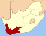
The Western Cape is a province
in the south west of South Africa. The capital is Cape Town
. Prior to 1994, the region that now forms the Western Cape was part of the much larger (and now defunct) Cape Province
. Prior to the formation of the Union of South Africa
in 1910, it was called the Cape Colony
(see the History of Cape Colony
).
, the southwestern corner of South Africa. It stretches about 400 kilometres (248.5 mi) northwards along the Atlantic coast and about 500 kilometre eastwards along the Indian Ocean coast. It is bordered on the north by the Northern Cape
and on the east by the Eastern Cape
. The total land area of the province is 129462 square kilometres (49,985.6 sq mi), about 10.6% of the country’s total. It is roughly the size of England or the US state of Louisiana
.
The Breede
, Berg
and Olifants Rivers are major rivers of the province. The capital is Cape Town
and other major cities include Stellenbosch, Worcester
, Paarl
, and George. The Garden Route
and the Overberg
are popular coastal tourism areas.
The Western Cape is exceptionally topographically diverse. Most of the province falls within the Cape Fold Belt
, a range of sandstone folded mountains of Permian
to Carboniferous
age that range in height from 1000m to 2300m. The valleys between ranges are generally very fertile and contains alluvial loamy to clay soils. The far interior forms part of the Karoo Basin and is generally arid and hilly with a sharp escarpment
in the north. Coastal areas range from sandy between capes, to rocky to steep and mountainous in places. The Western Cape is also the southernmost region of the African continent with Cape Agulhas
as its southernmost point, only 3800 km from the Antarctic coastline.
Vegetation is also extremely diverse, with one of the world's seven floral kingdoms almost exclusively endemic to the province, namely the Cape Floral Kingdom
, most of which is covered by Fynbos
(Afrikaans: Fine Bush). It is extremely rich in species diversity, with more plant species occurring on Table Mountain
than the entire United Kingdom. It is characterised by various types of shrubs, thousands of flowering plant species and some small trees.
The arid interior is dominated by Karoo
drought-resistant shrubbery. The West Coast and Little Karoo are semi-arid
regions and are typified by many species of succulents and drought-resistant shrubs and acacia trees. The Garden Route
is extremely lush, with temperate rainforest (or Afromontane Forest
) covering many areas adjacent to the coast and along the mountain ranges. Typical species are hardwoods of exceptional height, such as Yellowwood
, Stinkwood
and Ironwood
trees.
(warm water) and Atlantic (cold water) oceans, thus climatic statistics can vary greatly over short distances. Most of the province is considered to have a Mediterranean climate
with cool, wet winters and warm, dry summers. The interior Karoo
has a semi-arid
climate with cold, frosty winters and hot summers with occasional thunderstorms. The Garden Route
and the Overberg
on the south coast have a maritime climate with cool, moist winters and mild, moist summers. Mossel Bay
in the Garden Route is considered to have the second mildest climate worldwide after Hawaii.
Thunderstorms are generally rare in the province, except in the Karoo
interior, with most precipitation being of a frontal or orographic nature. Extremes of heat and cold are common inland, but rare near the coast. Snow is a common winter occurrence on the higher lying ground, however frost is relatively rare in coastal areas and many of the heavily cultivated valleys.
The dependency of the Prince Edward Islands
are subantarctic islands, which experience year-round cool to cold temperatures with high precipitation and little annual deviation on both accounts.
Population 1,000,000++
Population 200,000+
Population 50,000+
Population 10,000+
Population < 10,000
, the Cape Province was broken up into three provinces: Western Cape, Northern Cape
and Eastern Cape
(which encompasses the former Xhosa homelands of Transkei
and Ciskei
). However, the Western Cape set itself apart early in post-apartheid South African history by being one of the two provinces to have rejected an ANC
mandate (the other being KwaZulu-Natal
) by electing former South African Law and Order minister Hernus Kriel
(NP
) as the first premier of the Western Cape. It would be dominated by the National Party, and its successor, until the party's announced 2004 merger with the ANC, which brought ex-premier Ebrahim Rasool
to power.
 The capital of the Western Cape is the City of Cape Town
. The Premier of the Western Cape is Helen Zille
while the Director-General of the provincial administration is Virginia Petersen.
The Constitution of the Western Cape was adopted in 1998 and is published in the official languages of the province: Afrikaans
, English and Xhosa
.
The Western Cape Provincial Parliament
is responsible for creating laws within its responsibilities as set out by the South African Constitution. Some of the issues dealt with cover agriculture, education, environment, health services, housing, language policies, tourism, trade, and welfare. It is housed in Cape Town and has a total of 42 members. The Fourth Provincial Parliament was elected in the election of 22 April 2009
; 22 seats are held by the Democratic Alliance, 14 by the African National Congress
, 3 by the Congress of the People, 2 by the Independent Democrats, and 1 by the African Christian Democratic Party.
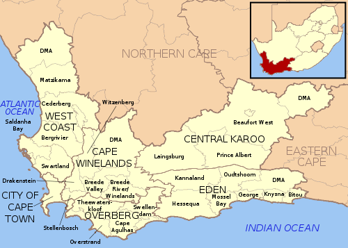 The Western Cape is made up of one metropolitan municipality
, and five district municipalities
subdivided into 24 local municipalities
.
268.26bn, making the province the third-highest contributor to the country’s total GDP, at 14.3%. In 2008 the province had the second fastest growing economy in the country growing at 4%, just behind Gauteng provice which grew at 4.1% in the same year. Close to 30% of the gross regional product comes from foreign trade. The province has a substantially lower unemployment rate than the national average (25%); 15% of the working population is unemployed.
The biggest sector in the Western Cape's economy is the financial, business services and realestate sectors contributing approximately R77 billion in 2008. Manufacturing was the second largest contributor valued at R43.7 billion in 2008 with the agricultural sector being th fastest growing at 10.6% in the same year. High-tech industries, international call centres, fashion design, advertising and TV production are niche industries rapidly gaining in importance. The city of Cape Town is ranked as the most entrepreneurial city in South Africa with Early-Stage Entrepreneurial Activity being 190% greater than South Africa’s national average.
(from Cape Town to Three Sisters, continuing outside the province towards Bloemfontein
and Johannesburg
), N2
(from Cape Town to Bloukrans River, towards Port Elizabeth), N7
(from Cape Town to Bitterfontein, continuing towards Springbok
and Namibia
) and N12
(from George to Three Sisters, continuing towards Kimberley
and Johannesburg). Other routes are the "R" roads which connect the smaller towns. All major roads are tarred with major rural gravel roads well maintained. Limited access motorways are limited to the Cape Metropolitan Area, Winelands and Garden Route, however due to the low population density of the remainder of the province, the highways remain efficient and high-speed, except during peak holiday travel seasons, when travel can be slow-going in places due to heavy traffic.
Telecommunications in the province are highly sophisticated. Landline telephones are available extensively, and the majority of large urban nodes have access to ADSL and other high-speed internet services. Mobile cellular networks are world-class, with reception extending from cities to highways and many remote rural areas. Mobile networks also play an important role in the internet space due to their speed and widespread availability. Major cities and towns have access to mobile internet speeds in excess of 21 Mbit/s (HSDPA+). In areas where HSDPA+ is not available, networks make provisions for HSDPA, 3G, EDGE or finally GPRS if demand does not warrant higher speed investment.
, there were 4,524,336 people in the Western Cape, living in 1,173,302 households. The population density was 34.97/km² and the household density 9.07/km². In terms of race, 53.91% of people described themselves as Coloured
, 26.68% as Black
, 18.41% as White
, and 1.00% as Indian or Asian
1.00%.
Age distribution in the province is spread out, with 27.3% under the age of 15, 19.4% from 15 to 24, 32.9% from 25 to 44, 15.2% from 45 to 64, and 5.2% who are 65 years of age or older. The median age is 26 years. For every 100 females there are 94.0 males. For every 100 females age 18 and over, there are 91.3 males.
In the province 55.3% of residents speak Afrikaans
at home, 23.7% speak Xhosa
, 19.3% speak English, and less than 2% speak another language.
81.8% of residents are Christian, 9.0% have no religion
, 6.5% are Muslim, 0.4% are Jewish, and 0.2% are Hindu
. 2.1% have other or undetermined beliefs.
5.7% of residents aged 20 and over have received no schooling, 15.2% have had some primary, 7.9% have completed only primary school, 36.5% have had some high education, 23.4% have finished only high school, and 11.2% have an education higher than the high school level. Overall, 34.6% of residents have completed high school.
63.1% of housing units have a telephone and/or cell-phone in the dwelling, 34.2% have access to a phone nearby, and 2.7% have access that is not nearby or no access. 86.5% of households have a flush or chemical toilet. 87.8% have refuse removed by the municipality at least once a week and 1.4% have no rubbish disposal. 67.5% have running water inside their dwelling, 85.2% have running water on their property, and 98.3% have access to running water. 78.8% of households use electricity for cooking, 73.4% for heating, and 88.0% for lighting. 79.1% of households have a radio, 74.1% have a television, 18.2% own a computer, 73.5% have a refrigerator, and 41.4% have a cell-phone.
17.1% of the population aged 15–65 is unemployed. Of the unemployed persons, 53.4% are Black, 43.0% are Coloured, 0.4% are Indian/Asian, and 3.2% are White. 23.3% of Black are unemployed, 9.3% of Coloureds, 5.0% of Indians/Asians, and 2.0% of Whites.
The median annual income of working adults aged 15–65 in the Western Cape is R
18,703. Males have a median annual income of R 21,048 versus R 17,035 for females. The median annual income by race is R 12,213 for Blacks, R 16,354 for Coloureds, R 42,803 for Indians/Asians, and R 64,968 for Whites.
 The Western Cape is the most highly educated province with a very skilled workforce in comparison to any other African region. The high school graduation rate is consistently around 80%, higher than any other province. The proportion of adults with a degree or higher was 4.8% (2005), the highest in the country.
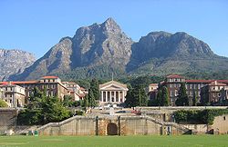
The province also boasts three internationally acclaimed universities, namely the University of Cape Town
, Stellenbosch University
and the University of the Western Cape
.
Provinces of South Africa
South Africa is currently divided into nine provinces. On the eve of the 1994 general election, South Africa's former homelands, also known as Bantustans, were reintegrated and the four existing provinces were divided into nine. The twelfth, thirteenth and sixteenth amendments to the constitution...
in the south west of South Africa. The capital is Cape Town
Cape Town
Cape Town is the second-most populous city in South Africa, and the provincial capital and primate city of the Western Cape. As the seat of the National Parliament, it is also the legislative capital of the country. It forms part of the City of Cape Town metropolitan municipality...
. Prior to 1994, the region that now forms the Western Cape was part of the much larger (and now defunct) Cape Province
Cape Province
The Province of the Cape of Good Hope was a province in the Union of South Africa and subsequently the Republic of South Africa...
. Prior to the formation of the Union of South Africa
Union of South Africa
The Union of South Africa is the historic predecessor to the present-day Republic of South Africa. It came into being on 31 May 1910 with the unification of the previously separate colonies of the Cape, Natal, Transvaal and the Orange Free State...
in 1910, it was called the Cape Colony
Cape Colony
The Cape Colony, part of modern South Africa, was established by the Dutch East India Company in 1652, with the founding of Cape Town. It was subsequently occupied by the British in 1795 when the Netherlands were occupied by revolutionary France, so that the French revolutionaries could not take...
(see the History of Cape Colony
History of Cape Colony
The written history of Cape Colony South Africa began when Bartolomeu Dias, a Portuguese navigator, discovered the Cape of Good Hope in 1488. In 1497, Vasco da Gama sailed along the whole coast of South Africa on his way to India. The Portuguese, attracted by the riches of Asia, made no...
).
Geography
The Western Cape is roughly L-shaped, extending north and east from the Cape of Good HopeCape of Good Hope
The Cape of Good Hope is a rocky headland on the Atlantic coast of the Cape Peninsula, South Africa.There is a misconception that the Cape of Good Hope is the southern tip of Africa, because it was once believed to be the dividing point between the Atlantic and Indian Oceans. In fact, the...
, the southwestern corner of South Africa. It stretches about 400 kilometres (248.5 mi) northwards along the Atlantic coast and about 500 kilometre eastwards along the Indian Ocean coast. It is bordered on the north by the Northern Cape
Northern Cape
The Northern Cape is the largest and most sparsely populated province of South Africa. It was created in 1994 when the Cape Province was split up. Its capital is Kimberley. It includes the Kalahari Gemsbok National Park, part of an international park shared with Botswana...
and on the east by the Eastern Cape
Eastern Cape
The Eastern Cape is a province of South Africa. Its capital is Bhisho, but its two largest cities are Port Elizabeth and East London. It was formed in 1994 out of the "independent" Xhosa homelands of Transkei and Ciskei, together with the eastern portion of the Cape Province...
. The total land area of the province is 129462 square kilometres (49,985.6 sq mi), about 10.6% of the country’s total. It is roughly the size of England or the US state of Louisiana
Louisiana
Louisiana is a state located in the southern region of the United States of America. Its capital is Baton Rouge and largest city is New Orleans. Louisiana is the only state in the U.S. with political subdivisions termed parishes, which are local governments equivalent to counties...
.
The Breede
Breede River
The Breede River , is a river in the Western Cape Province of South Africa. Travelling inland north from Cape Town, the river runs in a west to east direction, the surrounding western mountains thus forming the first continental divide experienced by European settlers in the 18th century...
, Berg
Berg River
The Berg River is a river located just north of Cape Town in the Western Cape Province of South Africa. It is approximately 294 km long with a catchment area of 7,715 km² and outlets into the Atlantic Ocean. About 65% of the Berg River area is under agriculture...
and Olifants Rivers are major rivers of the province. The capital is Cape Town
Cape Town
Cape Town is the second-most populous city in South Africa, and the provincial capital and primate city of the Western Cape. As the seat of the National Parliament, it is also the legislative capital of the country. It forms part of the City of Cape Town metropolitan municipality...
and other major cities include Stellenbosch, Worcester
Worcester, Western Cape
Worcester is a town in the Western Cape, South Africa. It is located 120 km north-east of Cape Town on the N1 highway north to Johannesburg....
, Paarl
Paarl
Paarl is a town with 191,013 inhabitants in the Western Cape province of South Africa. Its the third oldest European settlement in the Republic of South Africa and the largest town in the Cape Winelands. Due to the growth of the Mbekweni township, it is now a de facto urban unit with Wellington...
, and George. The Garden Route
Garden Route
The Garden Route is a popular stretch of the south-eastern coast of South Africa. It stretches from Heidelberg in the Western Cape to the Storms River which is crossed along the N2 coastal highway over the Paul Sauer Bridge in the extreme western reach of the neighbouring Eastern Cape...
and the Overberg
Overberg
Overberg is a district in South Africa to the east of Cape Town beyond the Hottentots-Holland mountains. It lies along the Cape Province's south coast between the Cape Peninsula and the region known as the Garden Route in the east...
are popular coastal tourism areas.
The Western Cape is exceptionally topographically diverse. Most of the province falls within the Cape Fold Belt
Cape Fold Belt
The Cape Fold Belt is the folded sedimentary sequence of rocks in the southwestern corner of South Africa. It is related to the Ventana Mountains near Bahía Blanca in Argentina...
, a range of sandstone folded mountains of Permian
Permian
The PermianThe term "Permian" was introduced into geology in 1841 by Sir Sir R. I. Murchison, president of the Geological Society of London, who identified typical strata in extensive Russian explorations undertaken with Edouard de Verneuil; Murchison asserted in 1841 that he named his "Permian...
to Carboniferous
Carboniferous
The Carboniferous is a geologic period and system that extends from the end of the Devonian Period, about 359.2 ± 2.5 Mya , to the beginning of the Permian Period, about 299.0 ± 0.8 Mya . The name is derived from the Latin word for coal, carbo. Carboniferous means "coal-bearing"...
age that range in height from 1000m to 2300m. The valleys between ranges are generally very fertile and contains alluvial loamy to clay soils. The far interior forms part of the Karoo Basin and is generally arid and hilly with a sharp escarpment
Escarpment
An escarpment is a steep slope or long cliff that occurs from erosion or faulting and separates two relatively level areas of differing elevations.-Description and variants:...
in the north. Coastal areas range from sandy between capes, to rocky to steep and mountainous in places. The Western Cape is also the southernmost region of the African continent with Cape Agulhas
Cape Agulhas
Cape Agulhas is a rocky headland in the Western Cape, South Africa. It is the geographic southern tip of Africa and the official dividing point between the Atlantic and Indian oceans...
as its southernmost point, only 3800 km from the Antarctic coastline.
Vegetation is also extremely diverse, with one of the world's seven floral kingdoms almost exclusively endemic to the province, namely the Cape Floral Kingdom
Cape floristic region
The Cape Floristic Region is a floristic region located near the southern tip of South Africa. It is the only floristic region of the Cape Floristic Kingdom, and includes only one floristic province, known as the Cape Floristic Province.The Cape Floristic Region, the smallest of the six recognised...
, most of which is covered by Fynbos
Fynbos
Fynbos is the natural shrubland or heathland vegetation occurring in a small belt of the Western Cape of South Africa, mainly in winter rainfall coastal and mountainous areas with a Mediterranean climate...
(Afrikaans: Fine Bush). It is extremely rich in species diversity, with more plant species occurring on Table Mountain
Table Mountain
Table Mountain is a flat-topped mountain forming a prominent landmark overlooking the city of Cape Town in South Africa, and is featured in the flag of Cape Town and other local government insignia. It is a significant tourist attraction, with many visitors using the cableway or hiking to the top...
than the entire United Kingdom. It is characterised by various types of shrubs, thousands of flowering plant species and some small trees.
The arid interior is dominated by Karoo
Karoo
The Karoo is a semi-desert region of South Africa. It has two main sub-regions - the Great Karoo in the north and the Little Karoo in the south. The 'High' Karoo is one of the distinct physiographic provinces of the larger South African Platform division.-Great Karoo:The Great Karoo has an area of...
drought-resistant shrubbery. The West Coast and Little Karoo are semi-arid
Semi-arid
A semi-arid climate or steppe climate describes climatic regions that receive precipitation below potential evapotranspiration, but not extremely...
regions and are typified by many species of succulents and drought-resistant shrubs and acacia trees. The Garden Route
Garden Route
The Garden Route is a popular stretch of the south-eastern coast of South Africa. It stretches from Heidelberg in the Western Cape to the Storms River which is crossed along the N2 coastal highway over the Paul Sauer Bridge in the extreme western reach of the neighbouring Eastern Cape...
is extremely lush, with temperate rainforest (or Afromontane Forest
Knysna-Amatole montane forests
The Knysna-Amatole montane forests ecoregion, of the Tropical and subtropical moist broadleaf forests Biome, is in South Africa. It covers an Afromontane area of in South Africa's Eastern Cape and Western Cape provinces.-Setting:...
) covering many areas adjacent to the coast and along the mountain ranges. Typical species are hardwoods of exceptional height, such as Yellowwood
Podocarpus
Podocarpus is a genus of conifers, the most numerous and widely distributed of the podocarp family Podocarpaceae. The 105 species of Podocarpus are evergreen shrubs or trees from 1-25 m in height...
, Stinkwood
Stinkwood
Stinkwood is the common name for a number of trees or shrubs which have wood with an unpleasant odour, including:*Celtis africana – native to South Africa...
and Ironwood
Ironwood
Ironwood is a common name for a large number of woods that have a reputation for hardness. Usage of the name may include the tree that yields this wood...
trees.
Climate
The Western Cape is also diverse climatologically, with many distinct micro- and macroclimates created by the varied topography and the influence of both the IndianIndian Ocean
The Indian Ocean is the third largest of the world's oceanic divisions, covering approximately 20% of the water on the Earth's surface. It is bounded on the north by the Indian Subcontinent and Arabian Peninsula ; on the west by eastern Africa; on the east by Indochina, the Sunda Islands, and...
(warm water) and Atlantic (cold water) oceans, thus climatic statistics can vary greatly over short distances. Most of the province is considered to have a Mediterranean climate
Mediterranean climate
A Mediterranean climate is the climate typical of most of the lands in the Mediterranean Basin, and is a particular variety of subtropical climate...
with cool, wet winters and warm, dry summers. The interior Karoo
Karoo
The Karoo is a semi-desert region of South Africa. It has two main sub-regions - the Great Karoo in the north and the Little Karoo in the south. The 'High' Karoo is one of the distinct physiographic provinces of the larger South African Platform division.-Great Karoo:The Great Karoo has an area of...
has a semi-arid
Semi-arid
A semi-arid climate or steppe climate describes climatic regions that receive precipitation below potential evapotranspiration, but not extremely...
climate with cold, frosty winters and hot summers with occasional thunderstorms. The Garden Route
Garden Route
The Garden Route is a popular stretch of the south-eastern coast of South Africa. It stretches from Heidelberg in the Western Cape to the Storms River which is crossed along the N2 coastal highway over the Paul Sauer Bridge in the extreme western reach of the neighbouring Eastern Cape...
and the Overberg
Overberg
Overberg is a district in South Africa to the east of Cape Town beyond the Hottentots-Holland mountains. It lies along the Cape Province's south coast between the Cape Peninsula and the region known as the Garden Route in the east...
on the south coast have a maritime climate with cool, moist winters and mild, moist summers. Mossel Bay
Mossel Bay
Mossel Bay is a harbour town of about 130,000 people on the Southern Cape of South Africa. It is an important tourism and farming region of the Western Cape Province...
in the Garden Route is considered to have the second mildest climate worldwide after Hawaii.
Thunderstorms are generally rare in the province, except in the Karoo
Karoo
The Karoo is a semi-desert region of South Africa. It has two main sub-regions - the Great Karoo in the north and the Little Karoo in the south. The 'High' Karoo is one of the distinct physiographic provinces of the larger South African Platform division.-Great Karoo:The Great Karoo has an area of...
interior, with most precipitation being of a frontal or orographic nature. Extremes of heat and cold are common inland, but rare near the coast. Snow is a common winter occurrence on the higher lying ground, however frost is relatively rare in coastal areas and many of the heavily cultivated valleys.
The dependency of the Prince Edward Islands
Prince Edward Islands
The Prince Edward Islands are two small islands in the sub-antarctic Indian Ocean that are part of South Africa. The islands, named Marion Island and Prince Edward Island, are located at ....
are subantarctic islands, which experience year-round cool to cold temperatures with high precipitation and little annual deviation on both accounts.
- Cape Town International AirportCape Town International AirportCape Town International Airport is the primary airport serving the city of Cape Town, and is the second busiest airport in South Africa and third busiest in Africa. Located approximately from the city centre, the airport was opened in 1954 to replace Cape Town's previous airport in the suburb of...
averages: January maximum: 26 °C (min: 16 °C), July maximum: 18 °C (min: 7 °C), annual rainfall: 515mm- Kirstenbosch, Cape TownCape TownCape Town is the second-most populous city in South Africa, and the provincial capital and primate city of the Western Cape. As the seat of the National Parliament, it is also the legislative capital of the country. It forms part of the City of Cape Town metropolitan municipality...
annual rainfall: 1395mm
- Kirstenbosch, Cape Town
- GeorgeGeorge, Western CapeGeorge is a city with 203,253 inhabitants in South Africa's Western Cape province. The city is a popular holiday and conference centre and the administrative and commercial hub of the Garden Route.- Location :...
averages: January maximum: 25 °C (min: 15 °C), July maximum: 19 °C (min: 7 °C), annual rainfall: 715mm - Marion Island (Prince Edward Group) averages: January maximum: 10 °C (min: 5 °C), July maximum: 6 °C (min: 1 °C), annual rainfall: 2401mm
Cities and towns
The population figures quoted only include urbanised areas:Population 1,000,000++
- Cape TownCape TownCape Town is the second-most populous city in South Africa, and the provincial capital and primate city of the Western Cape. As the seat of the National Parliament, it is also the legislative capital of the country. It forms part of the City of Cape Town metropolitan municipality...
Population 200,000+
- GeorgeGeorge, Western CapeGeorge is a city with 203,253 inhabitants in South Africa's Western Cape province. The city is a popular holiday and conference centre and the administrative and commercial hub of the Garden Route.- Location :...
- Somerset WestSomerset West, Western CapeSomerset West |metropolitan municipality]]. In the Western Cape, South Africa It is situated in the Helderberg area , about east of Cape Town and from Strand....
Population 50,000+
|
|
Swellendam Swellendam is the third oldest town in the Republic of South Africa, a town with 28,072 inhabitants situated in the Western Cape province. The town has over 50 National monuments most of them buildings of Cape Dutch architecture.... Worcester, Western Cape Worcester is a town in the Western Cape, South Africa. It is located 120 km north-east of Cape Town on the N1 highway north to Johannesburg.... |
Population 10,000+
|
Malmesbury, Western Cape Malmesbury is a town with 37,529 inhabitants in the Western Cape province of South Africa, about 65 km north of Cape Town.The town is the largest in the Swartland due to the dark "Renosterbos" , an indigenous plant that turns black in the warm, dry summers... Montagu, Western Cape Montagu is a town in the Western Cape province of South Africa, about 180 km from Cape Town in western Kannaland. It is named after former secretary of the Cape Colony, John Montagu, but was once known as Agter Cogman’s Kloof. It is situated at the confluence of the Keisie and Kingna... |
Plettenberg Bay Plettenberg Bay, nicknamed Plet or Plett, is the primary town of the Bitou Local Municipality in the Western Cape Province of South Africa. As of the census of 2001, there were 29149 population... Riversdale, Western Cape Riversdale is a town located on the N2 highway between Cape Town and George on the Agulhas Coastal Plain of the southern Western Cape province of South Africa. It is an agricultural service orientated town, being a hub for shopping and other services for surrounding farming communities, smaller... Robertson, Western Cape Robertson is a town in the Western Cape Province of South Africa known as the valley of wine and roses. It was founded in 1853 and named after the Scottish Dutch Reformed Church Minister, Dr William Robertson.... |
Tulbagh Tulbagh is a town in the Tulbagh valley and is situated in the Witzenberg Local Municipality, with the valley called "Die Land van Waveren" locally. Closest towns are Wolseley, Prince Alfred's Hamlet, Gouda and Ceres in the Boland district of the Western Cape Province, South Africa.The valley has... Wellington, Western Cape Wellington is a town in the Western Cape Winelands 45 minutes from Cape Town, in South Africa with a population of approximately 58,300. Wellington's economy is centered around agriculture such as wine, table grapes, citrus fruit and a brandy industry. The town is located 75 km north-east of... |
Population < 10,000
|
Napier, Western Cape Through rolling hills of Canola, wheat and barley, you’ll find the charming village of Napier at the foot of the Soetmuisberg, between Caledon and Bredasdorp... Struisbaai Struisbaai is a coastal settlement in the Overberg region of South Africa's Western Cape province. The town is two hours South from Cape Town in the Cape Agulhas Local Municipality within the Overberg District, and four kilometers from the southernmost point of the African continent at Cape... |
History since 1994
In 1994, after the inauguration of South Africa's first black president, Nelson MandelaNelson Mandela
Nelson Rolihlahla Mandela served as President of South Africa from 1994 to 1999, and was the first South African president to be elected in a fully representative democratic election. Before his presidency, Mandela was an anti-apartheid activist, and the leader of Umkhonto we Sizwe, the armed wing...
, the Cape Province was broken up into three provinces: Western Cape, Northern Cape
Northern Cape
The Northern Cape is the largest and most sparsely populated province of South Africa. It was created in 1994 when the Cape Province was split up. Its capital is Kimberley. It includes the Kalahari Gemsbok National Park, part of an international park shared with Botswana...
and Eastern Cape
Eastern Cape
The Eastern Cape is a province of South Africa. Its capital is Bhisho, but its two largest cities are Port Elizabeth and East London. It was formed in 1994 out of the "independent" Xhosa homelands of Transkei and Ciskei, together with the eastern portion of the Cape Province...
(which encompasses the former Xhosa homelands of Transkei
Transkei
The Transkei , officially the Republic of Transkei , was a Bantustan—an area set aside for members of a specific ethnicity—and nominal parliamentary democracy in the southeastern region of South Africa...
and Ciskei
Ciskei
Ciskei was a Bantustan in the south east of South Africa. It covered an area of 2,970 square miles , almost entirely surrounded by what was then the Cape Province, and possessed a small coastline along the shore of the Indian Ocean....
). However, the Western Cape set itself apart early in post-apartheid South African history by being one of the two provinces to have rejected an ANC
African National Congress
The African National Congress is South Africa's governing Africanist political party, supported by its tripartite alliance with the Congress of South African Trade Unions and the South African Communist Party , since the establishment of non-racial democracy in April 1994. It defines itself as a...
mandate (the other being KwaZulu-Natal
KwaZulu-Natal
KwaZulu-Natal is a province of South Africa. Prior to 1994, the territory now known as KwaZulu-Natal was made up of the province of Natal and the homeland of KwaZulu....
) by electing former South African Law and Order minister Hernus Kriel
Hernus Kriel
Hernus Kriel was the first Premier of the Western Cape province. He previously served as the Minister of Law and Order in the South African government under Frederik Willem de Klerk....
(NP
National Party (South Africa)
The National Party is a former political party in South Africa. Founded in 1914, it was the governing party of the country from 4 June 1948 until 9 May 1994. Members of the National Party were sometimes known as Nationalists or Nats. Its policies included apartheid, the establishment of a...
) as the first premier of the Western Cape. It would be dominated by the National Party, and its successor, until the party's announced 2004 merger with the ANC, which brought ex-premier Ebrahim Rasool
Ebrahim Rasool
Ebrahim Rasool was the Premier of the Western Cape province in South Africa. He is a member of the African National Congress.Anti-Apartheid Struggle Activist:...
to power.
Law and government
Cape Town
Cape Town is the second-most populous city in South Africa, and the provincial capital and primate city of the Western Cape. As the seat of the National Parliament, it is also the legislative capital of the country. It forms part of the City of Cape Town metropolitan municipality...
. The Premier of the Western Cape is Helen Zille
Helen Zille
Helen Zille is the Premier of the Western Cape, a member of the Western Cape Provincial Parliament, leader of South Africa's opposition Democratic Alliance political party, and a former Mayor of Cape Town.Zille is a former journalist and anti-apartheid activist, and famously exposed the truth...
while the Director-General of the provincial administration is Virginia Petersen.
The Constitution of the Western Cape was adopted in 1998 and is published in the official languages of the province: Afrikaans
Afrikaans
Afrikaans is a West Germanic language, spoken natively in South Africa and Namibia. It is a daughter language of Dutch, originating in its 17th century dialects, collectively referred to as Cape Dutch .Afrikaans is a daughter language of Dutch; see , , , , , .Afrikaans was historically called Cape...
, English and Xhosa
Xhosa language
Xhosa is one of the official languages of South Africa. Xhosa is spoken by approximately 7.9 million people, or about 18% of the South African population. Like most Bantu languages, Xhosa is a tonal language, that is, the same sequence of consonants and vowels can have different meanings when said...
.
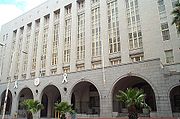
The Western Cape Provincial Parliament
Western Cape Provincial Parliament
The Western Cape Provincial Parliament is the legislature of the Western Cape province of South Africa. It is located in the Provincial Government Building at 7 Wale Street, Cape Town....
is responsible for creating laws within its responsibilities as set out by the South African Constitution. Some of the issues dealt with cover agriculture, education, environment, health services, housing, language policies, tourism, trade, and welfare. It is housed in Cape Town and has a total of 42 members. The Fourth Provincial Parliament was elected in the election of 22 April 2009
South African general election, 2009
South Africa held national and provincial elections to elect a new National Assembly as well as the provincial legislature in each province on 22 April 2009....
; 22 seats are held by the Democratic Alliance, 14 by the African National Congress
African National Congress
The African National Congress is South Africa's governing Africanist political party, supported by its tripartite alliance with the Congress of South African Trade Unions and the South African Communist Party , since the establishment of non-racial democracy in April 1994. It defines itself as a...
, 3 by the Congress of the People, 2 by the Independent Democrats, and 1 by the African Christian Democratic Party.
Municipalities
Metropolitan municipality (South Africa)
In South Africa, a metropolitan municipality or Category A municipality is a municipality which executes all the functions of local government for a city or conurbation...
, and five district municipalities
District municipality (South Africa)
In South Africa, a district municipality or Category C municipality is a municipality which executes some of the functions of local government for a district. The district municipality will in turn comprise several local municipalities, with which it shares the functions of local government...
subdivided into 24 local municipalities
Local municipality (South Africa)
In South Africa, a local municipality or Category B municipality is a type of municipality that serves as the third, and most local, tier of local government...
.
|
Eden District Municipality The Eden District Municipality is a district municipality located in the Western Cape Province of South Africa. Its municipality code is DC4.-Adjacent municipalities:* Central Karoo District Municipality...
Central Karoo District Municipality The Central Karoo District Municipality is a district municipality located in the Western Cape Province of South Africa...
|
Economy
The Western Cape's total GDP for 2008 was RSouth African rand
The rand is the currency of South Africa. It takes its name from the Witwatersrand , the ridge upon which Johannesburg is built and where most of South Africa's gold deposits were found. The rand has the symbol "R" and is subdivided into 100 cents, symbol "c"...
268.26bn, making the province the third-highest contributor to the country’s total GDP, at 14.3%. In 2008 the province had the second fastest growing economy in the country growing at 4%, just behind Gauteng provice which grew at 4.1% in the same year. Close to 30% of the gross regional product comes from foreign trade. The province has a substantially lower unemployment rate than the national average (25%); 15% of the working population is unemployed.
The biggest sector in the Western Cape's economy is the financial, business services and realestate sectors contributing approximately R77 billion in 2008. Manufacturing was the second largest contributor valued at R43.7 billion in 2008 with the agricultural sector being th fastest growing at 10.6% in the same year. High-tech industries, international call centres, fashion design, advertising and TV production are niche industries rapidly gaining in importance. The city of Cape Town is ranked as the most entrepreneurial city in South Africa with Early-Stage Entrepreneurial Activity being 190% greater than South Africa’s national average.
Infrastructure and communications
The Western Cape has an excellent network of highways comparable with any first-world country. The primary highways are the N1N1 (South Africa)
The N1 is a South African National Route, running from Cape Town to Beit Bridge on the border with Zimbabwe. It is also the main road link between Johannesburg and Cape Town, and forms the first section of the famed Cape to Cairo Road....
(from Cape Town to Three Sisters, continuing outside the province towards Bloemfontein
Bloemfontein
Bloemfontein is the capital city of the Free State Province of South Africa; and, as the judicial capital of the nation, one of South Africa's three national capitals – the other two being Cape Town, the legislative capital, and Pretoria, the administrative capital.Bloemfontein is popularly and...
and Johannesburg
Johannesburg
Johannesburg also known as Jozi, Jo'burg or Egoli, is the largest city in South Africa, by population. Johannesburg is the provincial capital of Gauteng, the wealthiest province in South Africa, having the largest economy of any metropolitan region in Sub-Saharan Africa...
), N2
N2 (South Africa)
The N2 is a National Route in South Africa; it is the main highway along the Indian Ocean coast of the country. The N2 starts in Cape Town in the Western Cape and runs through the cities of Port Elizabeth and East London in the Eastern Cape and Durban in KwaZulu-Natal to end at Ermelo in...
(from Cape Town to Bloukrans River, towards Port Elizabeth), N7
N7 (South Africa)
The N7 is a National Route in South Africa, connecting Cape Town, South Africa to Vioolsdrif, a border post to Namibia. After crossing the border, it changes designation to B1 and runs north through Windhoek and the north of Namibia....
(from Cape Town to Bitterfontein, continuing towards Springbok
Springbok, Northern Cape
Springbok is the largest town in the Namaqualand area in the Northern Cape province of South Africa. it had a population of 10,294. Springbok is located on the N7 national road which connects the Cape with Namibia, and at the western end of the N14, which connects it with Upington and Pretoria...
and Namibia
Namibia
Namibia, officially the Republic of Namibia , is a country in southern Africa whose western border is the Atlantic Ocean. It shares land borders with Angola and Zambia to the north, Botswana to the east and South Africa to the south and east. It gained independence from South Africa on 21 March...
) and N12
N12 (South Africa)
The N12 is a National Route in South Africa. It is maintained by the South African National Roads Agency.- Route :The road starts in George in the Western Cape and ends in Witbank in Mpumalanga. The road runs roughly from south to north, however, once it passes Kimberley in the Northern Cape, it...
(from George to Three Sisters, continuing towards Kimberley
Kimberley, Northern Cape
Kimberley is a city in South Africa, and the capital of the Northern Cape. It is located near the confluence of the Vaal and Orange Rivers. The town has considerable historical significance due its diamond mining past and siege during the Second Boer War...
and Johannesburg). Other routes are the "R" roads which connect the smaller towns. All major roads are tarred with major rural gravel roads well maintained. Limited access motorways are limited to the Cape Metropolitan Area, Winelands and Garden Route, however due to the low population density of the remainder of the province, the highways remain efficient and high-speed, except during peak holiday travel seasons, when travel can be slow-going in places due to heavy traffic.
Telecommunications in the province are highly sophisticated. Landline telephones are available extensively, and the majority of large urban nodes have access to ADSL and other high-speed internet services. Mobile cellular networks are world-class, with reception extending from cities to highways and many remote rural areas. Mobile networks also play an important role in the internet space due to their speed and widespread availability. Major cities and towns have access to mobile internet speeds in excess of 21 Mbit/s (HSDPA+). In areas where HSDPA+ is not available, networks make provisions for HSDPA, 3G, EDGE or finally GPRS if demand does not warrant higher speed investment.
Demographics
As of the census of 2001South African National Census of 2001
The South African National Census of 2001 is the most recent national census of South Africa.The census was undertaken by Statistics South Africa and undertook to enumerate every person present in South Africa on the census night, 9–10 October 2001. The enumeration primarily took place from 10 to...
, there were 4,524,336 people in the Western Cape, living in 1,173,302 households. The population density was 34.97/km² and the household density 9.07/km². In terms of race, 53.91% of people described themselves as Coloured
Coloured
In the South African, Namibian, Zambian, Botswana and Zimbabwean context, the term Coloured refers to an heterogenous ethnic group who possess ancestry from Europe, various Khoisan and Bantu tribes of Southern Africa, West Africa, Indonesia, Madagascar, Malaya, India, Mozambique,...
, 26.68% as Black
Black people
The term black people is used in systems of racial classification for humans of a dark skinned phenotype, relative to other racial groups.Different societies apply different criteria regarding who is classified as "black", and often social variables such as class, socio-economic status also plays a...
, 18.41% as White
White people
White people is a term which usually refers to human beings characterized, at least in part, by the light pigmentation of their skin...
, and 1.00% as Indian or Asian
Asians in South Africa
The majority of the Asian South African population is Indian in origin, most of them descended from indentured workers transported to work in the 19th century on the sugar plantations of the eastern coastal area, then known as Natal. They are largely English speaking, although many also retain the...
1.00%.
Age distribution in the province is spread out, with 27.3% under the age of 15, 19.4% from 15 to 24, 32.9% from 25 to 44, 15.2% from 45 to 64, and 5.2% who are 65 years of age or older. The median age is 26 years. For every 100 females there are 94.0 males. For every 100 females age 18 and over, there are 91.3 males.
In the province 55.3% of residents speak Afrikaans
Afrikaans
Afrikaans is a West Germanic language, spoken natively in South Africa and Namibia. It is a daughter language of Dutch, originating in its 17th century dialects, collectively referred to as Cape Dutch .Afrikaans is a daughter language of Dutch; see , , , , , .Afrikaans was historically called Cape...
at home, 23.7% speak Xhosa
Xhosa language
Xhosa is one of the official languages of South Africa. Xhosa is spoken by approximately 7.9 million people, or about 18% of the South African population. Like most Bantu languages, Xhosa is a tonal language, that is, the same sequence of consonants and vowels can have different meanings when said...
, 19.3% speak English, and less than 2% speak another language.
81.8% of residents are Christian, 9.0% have no religion
Irreligion
Irreligion is defined as an absence of religion or an indifference towards religion. Sometimes it may also be defined more narrowly as hostility towards religion. When characterized as hostility to religion, it includes antitheism, anticlericalism and antireligion. When characterized as...
, 6.5% are Muslim, 0.4% are Jewish, and 0.2% are Hindu
Hinduism
Hinduism is the predominant and indigenous religious tradition of the Indian Subcontinent. Hinduism is known to its followers as , amongst many other expressions...
. 2.1% have other or undetermined beliefs.
5.7% of residents aged 20 and over have received no schooling, 15.2% have had some primary, 7.9% have completed only primary school, 36.5% have had some high education, 23.4% have finished only high school, and 11.2% have an education higher than the high school level. Overall, 34.6% of residents have completed high school.
63.1% of housing units have a telephone and/or cell-phone in the dwelling, 34.2% have access to a phone nearby, and 2.7% have access that is not nearby or no access. 86.5% of households have a flush or chemical toilet. 87.8% have refuse removed by the municipality at least once a week and 1.4% have no rubbish disposal. 67.5% have running water inside their dwelling, 85.2% have running water on their property, and 98.3% have access to running water. 78.8% of households use electricity for cooking, 73.4% for heating, and 88.0% for lighting. 79.1% of households have a radio, 74.1% have a television, 18.2% own a computer, 73.5% have a refrigerator, and 41.4% have a cell-phone.
17.1% of the population aged 15–65 is unemployed. Of the unemployed persons, 53.4% are Black, 43.0% are Coloured, 0.4% are Indian/Asian, and 3.2% are White. 23.3% of Black are unemployed, 9.3% of Coloureds, 5.0% of Indians/Asians, and 2.0% of Whites.
The median annual income of working adults aged 15–65 in the Western Cape is R
South African rand
The rand is the currency of South Africa. It takes its name from the Witwatersrand , the ridge upon which Johannesburg is built and where most of South Africa's gold deposits were found. The rand has the symbol "R" and is subdivided into 100 cents, symbol "c"...
18,703. Males have a median annual income of R 21,048 versus R 17,035 for females. The median annual income by race is R 12,213 for Blacks, R 16,354 for Coloureds, R 42,803 for Indians/Asians, and R 64,968 for Whites.
| Category | ||||||||||||||||||||||||||||||||||||||||||||||||
|---|---|---|---|---|---|---|---|---|---|---|---|---|---|---|---|---|---|---|---|---|---|---|---|---|---|---|---|---|---|---|---|---|---|---|---|---|---|---|---|---|---|---|---|---|---|---|---|---|
| No income | 2.0% | |||||||||||||||||||||||||||||||||||||||||||||||
| R 12 – R 4 800 ($2 – $721) | 6.5% | |||||||||||||||||||||||||||||||||||||||||||||||
| R 4 812 – R 9 600 ($723 – $1,443) | 17.7% | |||||||||||||||||||||||||||||||||||||||||||||||
| R 9 612 – R 19 200 ($1,445 – $2,886) | 25.1% | |||||||||||||||||||||||||||||||||||||||||||||||
| R 19 212 – R 38 400 ($2,888 – $5,772) | 20.1% | |||||||||||||||||||||||||||||||||||||||||||||||
| R 38 412 – R 76 800 ($5,774 – $11,543) | 15.2% | |||||||||||||||||||||||||||||||||||||||||||||||
| R 76 812 – R 153 600 ($11,545 – $23,087) | 8.3% | |||||||||||||||||||||||||||||||||||||||||||||||
| R 153 612 – R 307 200 ($23,089 – $46,174) | 3.3% | |||||||||||||||||||||||||||||||||||||||||||||||
| R 307 212 – R 614 400 ($46,176 – $92,348) | 1.1% | |||||||||||||||||||||||||||||||||||||||||||||||
| R 614 412 or more ($92,350+) | 0.7% | |||||||||||||||||||||||||||||||||||||||||||||||
Education
The province also boasts three internationally acclaimed universities, namely the University of Cape Town
University of Cape Town
The University of Cape Town is a public research university located in Cape Town in the Western Cape province of South Africa. UCT was founded in 1829 as the South African College, and is the oldest university in South Africa and the second oldest extant university in Africa.-History:The roots of...
, Stellenbosch University
Stellenbosch University
Stellenbosch University is a public research university situated in the town of Stellenbosch, South Africa. Other nearby universities are the University of Cape Town and University of the Western Cape....
and the University of the Western Cape
University of the Western Cape
The University of the Western Cape is a public university located in the Bellville suburb of Cape Town, South Africa. It was established in 1960 by the South African government as a university for Coloured people only...
.
- Universities
- Stellenbosch UniversityStellenbosch UniversityStellenbosch University is a public research university situated in the town of Stellenbosch, South Africa. Other nearby universities are the University of Cape Town and University of the Western Cape....
- University of Cape TownUniversity of Cape TownThe University of Cape Town is a public research university located in Cape Town in the Western Cape province of South Africa. UCT was founded in 1829 as the South African College, and is the oldest university in South Africa and the second oldest extant university in Africa.-History:The roots of...
- University of the Western CapeUniversity of the Western CapeThe University of the Western Cape is a public university located in the Bellville suburb of Cape Town, South Africa. It was established in 1960 by the South African government as a university for Coloured people only...
- Cape Peninsula University of TechnologyCape Peninsula University of TechnologyCape Peninsula University of Technology, a university in Cape Town, South Africa, is the only university of Technology in the Western Cape province, and is also the largest university in the province, with over 32,000 students.-History:...
- Stellenbosch University
- Other Educational Institutions
- South African Military AcademySouth African Military AcademyThe South African Military Academy is based on similar principles as that of the Military Academy system of the United States , and was established on 1 April 1950 under the auspices of the University of Pretoria, as a branch of the South African Military College in Voortrekkerhoogte...
- South African Military Academy