

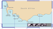
Cape Agulhas
Encyclopedia
Headland
A headland is a point of land, usually high and often with a sheer drop, that extends out into a body of water.Headland can also refer to:*Headlands and bays*headLand, an Australian television series...
in the Western Cape
Western Cape
The Western Cape is a province in the south west of South Africa. The capital is Cape Town. Prior to 1994, the region that now forms the Western Cape was part of the much larger Cape Province...
, South Africa
South Africa
The Republic of South Africa is a country in southern Africa. Located at the southern tip of Africa, it is divided into nine provinces, with of coastline on the Atlantic and Indian oceans...
. It is the geographic southern tip of Africa
Africa
Africa is the world's second largest and second most populous continent, after Asia. At about 30.2 million km² including adjacent islands, it covers 6% of the Earth's total surface area and 20.4% of the total land area...
and the official dividing point between the Atlantic
Atlantic Ocean
The Atlantic Ocean is the second-largest of the world's oceanic divisions. With a total area of about , it covers approximately 20% of the Earth's surface and about 26% of its water surface area...
and Indian
Indian Ocean
The Indian Ocean is the third largest of the world's oceanic divisions, covering approximately 20% of the water on the Earth's surface. It is bounded on the north by the Indian Subcontinent and Arabian Peninsula ; on the west by eastern Africa; on the east by Indochina, the Sunda Islands, and...
oceans. (The actual division between the oceans is the point where the Agulhas current
Agulhas Current
The Agulhas Current is the Western Boundary Current of the southwest Indian Ocean. It flows down the east coast of Africa from 27°S to 40°S. It is narrow, swift and strong...
meets the Benguela current
Benguela Current
The Benguela Current is the broad, northward flowing ocean current that forms the eastern portion of the South Atlantic Ocean gyre. The current extends from roughly Cape Point in the south, to the position of the Angola-Benguela Front in the north, at around 16°S. The current is driven by the...
, which fluctuates seasonally, between Cape Agulhas and Cape Point
Cape Point
Cape Point is a promontory at the southeast corner of the Cape Peninsula, which is a mountainous and scenic landform that runs north-south for about thirty kilometres at the extreme southwestern tip of the African continent in the Republic of South Africa. Table Mountain and the city of Cape Town...
.) Historically, the cape has been known to sailors as a major hazard on the traditional clipper route
Clipper route
In sailing, the clipper route was the traditional route sailed by clipper ships between Europe and the Far East, Australia and New Zealand. The route ran from west to east through the Southern Ocean, in order to make use of the strong westerly winds of the Roaring Forties...
and is sometimes regarded as one of the great capes
Great capes
In sailing, the great capes are the three major capes of the Southern Ocean — the Cape of Good Hope , Cape Leeuwin, and Cape Horn. South East Cape of Tasmania and South West Cape at the southern tip of Stewart Island/Rakiura are also sometimes included as major landmarks of a circumnavigation...
. It was most commonly known in English as Cape L'Agullas until the 20th century. The town of L'Agulhas is located near to the cape.
Geography
Africa
Africa is the world's second largest and second most populous continent, after Asia. At about 30.2 million km² including adjacent islands, it covers 6% of the Earth's total surface area and 20.4% of the total land area...
. It is located at 34°50′00"S 20°00′09.15"E in the Overberg
Overberg
Overberg is a district in South Africa to the east of Cape Town beyond the Hottentots-Holland mountains. It lies along the Cape Province's south coast between the Cape Peninsula and the region known as the Garden Route in the east...
region, 170 kilometres (105 mi) southeast of Cape Town
Cape Town
Cape Town is the second-most populous city in South Africa, and the provincial capital and primate city of the Western Cape. As the seat of the National Parliament, it is also the legislative capital of the country. It forms part of the City of Cape Town metropolitan municipality...
. The cape was named by Portuguese
Portuguese people
The Portuguese are a nation and ethnic group native to the country of Portugal, in the west of the Iberian peninsula of south-west Europe. Their language is Portuguese, and Roman Catholicism is the predominant religion....
navigators, who called it Cabo das Agulhas — Portuguese
Portuguese language
Portuguese is a Romance language that arose in the medieval Kingdom of Galicia, nowadays Galicia and Northern Portugal. The southern part of the Kingdom of Galicia became independent as the County of Portugal in 1095...
for "Cape of Needles" — after noticing that around the year 1500 the direction of magnetic north (and therefore the compass needle) coincided with true north
True north
True north is the direction along the earth's surface towards the geographic North Pole.True geodetic north usually differs from magnetic north , and from grid north...
in the region. The cape is within the Cape Agulhas Local Municipality
Cape Agulhas Local Municipality
Cape Agulhas Municipality is a municipality located in the Western Cape Province of South Africa. As of 2001, the population was 26,182. Its municipality code is WC033.- Government :...
in the Overberg District
Overberg District Municipality
The Overberg District Municipality is a district municipality located in the Western Cape province of South Africa. Its municipality code is DC3.- Adjacent municipalities :*Cape Winelands District Municipality *Eden District Municipality...
of the Western Cape
Western Cape
The Western Cape is a province in the south west of South Africa. The capital is Cape Town. Prior to 1994, the region that now forms the Western Cape was part of the much larger Cape Province...
province of South Africa
South Africa
The Republic of South Africa is a country in southern Africa. Located at the southern tip of Africa, it is divided into nine provinces, with of coastline on the Atlantic and Indian oceans...
. The official dividing line between the Indian
Indian Ocean
The Indian Ocean is the third largest of the world's oceanic divisions, covering approximately 20% of the water on the Earth's surface. It is bounded on the north by the Indian Subcontinent and Arabian Peninsula ; on the west by eastern Africa; on the east by Indochina, the Sunda Islands, and...
and Atlantic
Atlantic Ocean
The Atlantic Ocean is the second-largest of the world's oceanic divisions. With a total area of about , it covers approximately 20% of the Earth's surface and about 26% of its water surface area...
ocean
Ocean
An ocean is a major body of saline water, and a principal component of the hydrosphere. Approximately 71% of the Earth's surface is covered by ocean, a continuous body of water that is customarily divided into several principal oceans and smaller seas.More than half of this area is over 3,000...
s is defined by the International Hydrographic Organization
International Hydrographic Organization
The International Hydrographic Organization is the inter-governmental organisation representing the hydrographic community. It enjoys observer status at the UN and is the recognised competent authority on hydrographic surveying and nautical charting...
to pass through Cape Agulhas.
South of Cape Agulhas the warm Agulhas Current
Agulhas Current
The Agulhas Current is the Western Boundary Current of the southwest Indian Ocean. It flows down the east coast of Africa from 27°S to 40°S. It is narrow, swift and strong...
that flows south along the east coast of Africa retroflects back into the Indian Ocean. While retroflecting, it pinches off large ocean eddies (Agulhas rings) that drift into the South Atlantic Ocean and take enormous amounts of heat and salt into the neighboring ocean. This mechanism constitutes one of the key elements in the global conveyor belt
Thermohaline circulation
The term thermohaline circulation refers to a part of the large-scale ocean circulation that is driven by global density gradients created by surface heat and freshwater fluxes....
circulation of heat and salt.
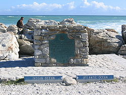
Unlike its better-known relative, the Cape of Good Hope
Cape of Good Hope
The Cape of Good Hope is a rocky headland on the Atlantic coast of the Cape Peninsula, South Africa.There is a misconception that the Cape of Good Hope is the southern tip of Africa, because it was once believed to be the dividing point between the Atlantic and Indian Oceans. In fact, the...
, Cape Agulhas is relatively unspectacular, consisting of a gradually curving coastline with a rocky beach. A survey marker indicates the location of the cape, which would otherwise be difficult to identify. The waters of the Agulhas Bank
Agulhas Bank
The Agulhas Bank is a broad, shallow part of the southern African continental shelf which extends south of Cape Agulhas before falling away steeply away to the abyssal plain....
off the coast are quite shallow and are renowned as one of the best fishing grounds in South Africa
South Africa
The Republic of South Africa is a country in southern Africa. Located at the southern tip of Africa, it is divided into nine provinces, with of coastline on the Atlantic and Indian oceans...
.
The rocks that form Cape Agulhas belong to the Table Mountain
Table Mountain
Table Mountain is a flat-topped mountain forming a prominent landmark overlooking the city of Cape Town in South Africa, and is featured in the flag of Cape Town and other local government insignia. It is a significant tourist attraction, with many visitors using the cableway or hiking to the top...
Group, often loosely termed the Table Mountain sandstone. They are closely linked to the geological formations that are exposed in the spectacular cliffs of Table Mountain, Cape Point
Cape Point
Cape Point is a promontory at the southeast corner of the Cape Peninsula, which is a mountainous and scenic landform that runs north-south for about thirty kilometres at the extreme southwestern tip of the African continent in the Republic of South Africa. Table Mountain and the city of Cape Town...
, and the Cape of Good Hope
Cape of Good Hope
The Cape of Good Hope is a rocky headland on the Atlantic coast of the Cape Peninsula, South Africa.There is a misconception that the Cape of Good Hope is the southern tip of Africa, because it was once believed to be the dividing point between the Atlantic and Indian Oceans. In fact, the...
.
The climate is extremely mild, with no temperature or rainfall extremes. The average rainfall is 500 mm per annum, mostly received in winter (unverified, as closest data is from Bredasdorp
Bredasdorp
Bredasdorp is a town in the Southern Overberg region of the Western Cape, South Africa, and the main economic and service hub of that region. It lies on the northern edge of the Agulhas Plain, about south-east of Cape Town and north of Cape Agulhas, the southernmost tip of Africa.-History:The...
). Temperature climate data is available for Cape Agulhas, averages are:
- Jan max: 23.8°C (min: 17.7°C); Jul max: 16.5°C (min: 10.8°C)
Shipping hazards
Freak wave
Rogue waves are relatively large and spontaneous ocean surface waves that occur far out in sea, and are a threat even to large ships and ocean liners...
s, which can range up to 30 metres (100 ft) high and can sink even large ships. These conditions are caused by a number of factors. The naturally strong winds of the roaring forties
Roaring Forties
The Roaring Forties is the name given to strong westerly winds found in the Southern Hemisphere, generally between the latitudes of 40 and 49 degrees. Air displaced from the Equator towards the South Pole, which travels close to the surface between the latitudes of 30 and 60 degrees south, combines...
, which blow from west to east, and the cold Antarctic Circumpolar Current
Antarctic Circumpolar Current
The Antarctic Circumpolar Current is an ocean current that flows from west to east around Antarctica. An alternative name for the ACC is the West Wind Drift. The ACC is the dominant circulation feature of the Southern Ocean and, at approximately 125 Sverdrups, the largest ocean current...
flowing in the same direction, come up against the warmer Agulhas Current
Agulhas Current
The Agulhas Current is the Western Boundary Current of the southwest Indian Ocean. It flows down the east coast of Africa from 27°S to 40°S. It is narrow, swift and strong...
in the region of the cape. These conflicting currents of water of different densities, and the west winds blowing against the Agulhas Current, can create extremely hazardous wave conditions; these are further exacerbated by the shallow waters of the Agulhas Bank
Agulhas Bank
The Agulhas Bank is a broad, shallow part of the southern African continental shelf which extends south of Cape Agulhas before falling away steeply away to the abyssal plain....
, a broad, shallow part of the continental shelf
Continental shelf
The continental shelf is the extended perimeter of each continent and associated coastal plain. Much of the shelf was exposed during glacial periods, but is now submerged under relatively shallow seas and gulfs, and was similarly submerged during other interglacial periods. The continental margin,...
which juts 250 kilometres (155 mi) south from the cape, after which it falls steeply away to the abyssal plain
Abyssal plain
An abyssal plain is an underwater plain on the deep ocean floor, usually found at depths between 3000 and 6000 metres. Lying generally between the foot of a continental rise and a mid-ocean ridge, abyssal plains cover more than 50% of the Earth’s surface. They are among the flattest, smoothest...
.
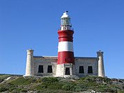
These hazards have combined to make the cape notorious among sailors. The coast here is littered with wrecks: Arniston
Arniston (ship)
The Arniston was an East Indiaman ship that was wrecked on 30 May 1815 during a storm at Waenhuiskrans, near Cape Agulhas, South Africa with the loss of 372 lives and only 6 survivors...
(1815), Cooranga (1964), Elise (1879), European (1877), Federal Lakes (1975), Geortyrder (1849), Gouritz (1981), and Gwendola (1968) are just a few of the vessels lost in the proximity of the "Cape of Needles." Owing to the hazards and following the loss of several vessels, notably the Arniston
Arniston (ship)
The Arniston was an East Indiaman ship that was wrecked on 30 May 1815 during a storm at Waenhuiskrans, near Cape Agulhas, South Africa with the loss of 372 lives and only 6 survivors...
, a lighthouse
Cape Agulhas Lighthouse
The Cape Agulhas Lighthouse is situated at Cape Agulhas, the southernmost tip of Africa. It was the third lighthouse to be built in South Africa, and the second-oldest still operating, after Green Point...
was built in 1848, this being only the second one to be built in the country. The lighthouse now holds a museum and a small rustic restaurant.
See also
- Cape Agulhas Local MunicipalityCape Agulhas Local MunicipalityCape Agulhas Municipality is a municipality located in the Western Cape Province of South Africa. As of 2001, the population was 26,182. Its municipality code is WC033.- Government :...
, the municipality containing Cape Agulhas. - Agulhas National ParkAgulhas National ParkThe Agulhas National Park is a South African national park located in the Agulhas Plain in the southern Overberg region of the Western Cape, about south-east of Cape Town. The park stetches along the coastal plain between the towns of Gansbaai and Struisbaai, and includes the southern tip of...
- Cape of Good HopeCape of Good HopeThe Cape of Good Hope is a rocky headland on the Atlantic coast of the Cape Peninsula, South Africa.There is a misconception that the Cape of Good Hope is the southern tip of Africa, because it was once believed to be the dividing point between the Atlantic and Indian Oceans. In fact, the...
, near Cape TownCape TownCape Town is the second-most populous city in South Africa, and the provincial capital and primate city of the Western Cape. As the seat of the National Parliament, it is also the legislative capital of the country. It forms part of the City of Cape Town metropolitan municipality...
, which is often incorrectly regarded as the southernmost point of Africa.