
Effects of Hurricane Isabel in New York and New England
Encyclopedia
The effects of Hurricane Isabel in New York and New England were relatively minor and primarily limited to wind damage. Hurricane Isabel
formed from a tropical wave
on September 6, 2003 in the tropical Atlantic Ocean
. It moved northwestward, and within an environment of light wind shear and warm waters it steadily strengthened to reach peak winds of 165 mph (265 km/h) on September 11. After fluctuating in intensity for four days, Isabel gradually weakened and made landfall on the Outer Banks
of North Carolina
with winds of 105 mph (165 km/h) on September 18. It quickly weakened over land and became extratropical
over western Pennsylvania
the next day.
Damage in New York
totaled $90 million (2003 USD, $105 million 2008 USD), with Vermont
reporting about $100,000 in damage (2003 USD, $117,000 in 2008 USD). Falling trees from moderate winds downed power lines across the region, causing sporadic power outages. Two people died as a result of the hurricane, both due to the rough surf from Isabel.
issued a tropical storm warning
for a portion of the southern Long Island
coastline from the New Jersey
/New York border to Moriches
. About a day before the hurricane moved ashore, forecasters estimated the hurricane possessed a 10% chance of passing within 75 miles (120 km) of New York City
. Other portions of southern New England
were estimated to have similar probabilities, with the same forecast predicting a 3% chance for it passing within 75 miles (120 km) of Eastport, Maine
. By about two days before Isabel struck land until several hours after it moved ashore, forecasters predicted the storm to pass over western New York as a transitioning tropical cyclone before passing into Canada
as an extratropical cyclone.
New York Governor George Pataki
urged residents to purchase emergency supplies and to fill cars with gasoline. The State Emergency Management Office began preparing for the hurricane about a week before it moved ashore. The office also issued a Level 1 emergency activation, with a planning unit readying contingency plans and in coordinating the efforts of other state offices. The state's National Guard
began preliminary preparations for possible support efforts by reviewing the list of personnel able to be mobilized in the event of an emergency. Army and Air National Guard officials identified needed equipment in the event of an emergency, such as helicopters, generators, high-axle vehicles, and communications equipment. State police officers established contingency plans for personnel and equipment to assist as needed. The State Office of Parks, Recreation and Historic Preservation ensured needed equipment were operational, and also secured buildings with sandbags to prevent flooding. Seven airlines allowed travelers potentially affected by the hurricane to reschedule their flights to a later date.
 The pressure gradient
between a ridge
and Isabel produced strong northeast winds of at least tropical storm force across southeastern New York. Shinnecock Inlet
recorded a peak gust of 52 mph (84 km/h). A station at LaGuardia Airport
recorded a wind gust of 51 mph (82 km/h), where airplane flights averaged a 90-minute delay. The strongest winds occurred in the outer rainband
s, during which many trees, tree limbs, and power lines fell across the region. In the New York metropolitan area
, moderate winds downed 640 trees and 801 tree limbs. A man driving through Great Neck Estates
was critically injured when a tree limb fell onto the car. Additionally, a falling tree branch hit a man in the head, resulting in a serious head injury. In and around New York City, about 1.1 million customers were left without power, though most outages were fixed by the day after the hurricane passed through the region. Offshore of Long Beach
, rough waves killed a man while bodysurfing. Further to the northwest the winds were not as severe, though in some places in the south-central portion of the state the winds downed some trees. A falling tree hit and damaged a car in Cobleskill
. The winds also knocked out power to about 3,000 customers in the Schoharie
and eastern Mohawk Valley
s. In the northeast portion of the state, a few trees and power lines were blown down in Moriah
, Westport
, and Lewis
. Precipitation was generally light in the state, with a few scattered locations reporting over 1 inch (25 mm). In Livingston County
, the rainfall overflowed the reservoir, causing moderate flood damage. Initially, gasoline futures on the New York Stock Exchange
rose in anticipation of a threat from the hurricane, though later dropped when the storm failed to disrupt oil refining facilities. The hurricane brought unusual birds to the western portion of the state, including petrel
s and shearwater
s normally found in salt-water regions or over the open ocean. Most of the birds died within a few days due to the sudden change in habitat. In Cayuga County
, downed power lines lit one building on fire, causing minor smoke and water damage though no injuries. Damage in the state totaled $90 million (2003 USD, $105 million 2008 USD).
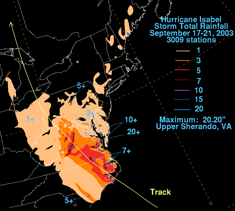
Rainfall reached 1 inch (25 mm) in portions of western Connecticut
and Massachusetts
. Strong surf from Isabel caused a man to drown after losing his footing along the beach near Narragansett, Rhode Island
, and being swept out to sea. Officials in Connecticut contacted a water company in Watertown
and a grocer in Cheshire
for donations to assist the residents affected in North Carolina
. A few days after Isabel moved ashore, the officials sent a tractor trailer truck with 2,000 gallons (7570 l) of water and 25,000 pounds (11,340 kg) of ice to North Carolina. In Vermont, the strong pressure gradient produced a peak wind gust of 55 mph (89 km/h) in Pleasant Valley, causing sporadic downed trees and power lines throughout the state. In Richmond
, trees fell on and damaged three trucks, and in Salisbury
a falling tree damaged a car. Damage in the state totaled about $100,000 (2003 USD, $117,000 in 2008 USD). Rainfall reached 1 inch (25 mm) in various portions of New Hampshire
and Maine
.
Hurricane Isabel
Hurricane Isabel was the costliest and deadliest hurricane in the 2003 Atlantic hurricane season. The ninth named storm, fifth hurricane, and second major hurricane of the season, Isabel formed near the Cape Verde Islands from a tropical wave on September 6 in the tropical Atlantic Ocean...
formed from a tropical wave
Tropical wave
Tropical waves, easterly waves, or tropical easterly waves, also known as African easterly waves in the Atlantic region, are a type of atmospheric trough, an elongated area of relatively low air pressure, oriented north to south, which move from east to west across the tropics causing areas of...
on September 6, 2003 in the tropical Atlantic Ocean
Atlantic Ocean
The Atlantic Ocean is the second-largest of the world's oceanic divisions. With a total area of about , it covers approximately 20% of the Earth's surface and about 26% of its water surface area...
. It moved northwestward, and within an environment of light wind shear and warm waters it steadily strengthened to reach peak winds of 165 mph (265 km/h) on September 11. After fluctuating in intensity for four days, Isabel gradually weakened and made landfall on the Outer Banks
Outer Banks
The Outer Banks is a 200-mile long string of narrow barrier islands off the coast of North Carolina, beginning in the southeastern corner of Virginia Beach on the east coast of the United States....
of North Carolina
North Carolina
North Carolina is a state located in the southeastern United States. The state borders South Carolina and Georgia to the south, Tennessee to the west and Virginia to the north. North Carolina contains 100 counties. Its capital is Raleigh, and its largest city is Charlotte...
with winds of 105 mph (165 km/h) on September 18. It quickly weakened over land and became extratropical
Extratropical cyclone
Extratropical cyclones, sometimes called mid-latitude cyclones or wave cyclones, are a group of cyclones defined as synoptic scale low pressure weather systems that occur in the middle latitudes of the Earth having neither tropical nor polar characteristics, and are connected with fronts and...
over western Pennsylvania
Pennsylvania
The Commonwealth of Pennsylvania is a U.S. state that is located in the Northeastern and Mid-Atlantic regions of the United States. The state borders Delaware and Maryland to the south, West Virginia to the southwest, Ohio to the west, New York and Ontario, Canada, to the north, and New Jersey to...
the next day.
Damage in New York
New York
New York is a state in the Northeastern region of the United States. It is the nation's third most populous state. New York is bordered by New Jersey and Pennsylvania to the south, and by Connecticut, Massachusetts and Vermont to the east...
totaled $90 million (2003 USD, $105 million 2008 USD), with Vermont
Vermont
Vermont is a state in the New England region of the northeastern United States of America. The state ranks 43rd in land area, , and 45th in total area. Its population according to the 2010 census, 630,337, is the second smallest in the country, larger only than Wyoming. It is the only New England...
reporting about $100,000 in damage (2003 USD, $117,000 in 2008 USD). Falling trees from moderate winds downed power lines across the region, causing sporadic power outages. Two people died as a result of the hurricane, both due to the rough surf from Isabel.
Preparations
Hours before Isabel made landfall on North Carolina, the National Hurricane CenterNational Hurricane Center
The National Hurricane Center , located at Florida International University in Miami, Florida, is the division of the National Weather Service responsible for tracking and predicting weather systems within the tropics between the Prime Meridian and the 140th meridian west poleward to the 30th...
issued a tropical storm warning
Tropical cyclone warnings and watches
Warnings and watches are two levels of alert issued by national weather forecasting bodies to coastal areas threatened by the imminent approach of a tropical cyclone of tropical storm or hurricane intensity. They are notices to the local population and civil authorities to make appropriate...
for a portion of the southern Long Island
Long Island
Long Island is an island located in the southeast part of the U.S. state of New York, just east of Manhattan. Stretching northeast into the Atlantic Ocean, Long Island contains four counties, two of which are boroughs of New York City , and two of which are mainly suburban...
coastline from the New Jersey
New Jersey
New Jersey is a state in the Northeastern and Middle Atlantic regions of the United States. , its population was 8,791,894. It is bordered on the north and east by the state of New York, on the southeast and south by the Atlantic Ocean, on the west by Pennsylvania and on the southwest by Delaware...
/New York border to Moriches
Moriches, New York
Moriches is a hamlet in Suffolk County, New York, United States. The population was 2,319 at the 2000 census.Moriches is served by the William Floyd School District....
. About a day before the hurricane moved ashore, forecasters estimated the hurricane possessed a 10% chance of passing within 75 miles (120 km) of New York City
New York City
New York is the most populous city in the United States and the center of the New York Metropolitan Area, one of the most populous metropolitan areas in the world. New York exerts a significant impact upon global commerce, finance, media, art, fashion, research, technology, education, and...
. Other portions of southern New England
New England
New England is a region in the northeastern corner of the United States consisting of the six states of Maine, New Hampshire, Vermont, Massachusetts, Rhode Island, and Connecticut...
were estimated to have similar probabilities, with the same forecast predicting a 3% chance for it passing within 75 miles (120 km) of Eastport, Maine
Eastport, Maine
Eastport is a small city in Washington County, Maine, United States. The population was 1,640 at the 2000 census. The principal island is Moose Island, which is connected to the mainland by causeway...
. By about two days before Isabel struck land until several hours after it moved ashore, forecasters predicted the storm to pass over western New York as a transitioning tropical cyclone before passing into Canada
Canada
Canada is a North American country consisting of ten provinces and three territories. Located in the northern part of the continent, it extends from the Atlantic Ocean in the east to the Pacific Ocean in the west, and northward into the Arctic Ocean...
as an extratropical cyclone.
New York Governor George Pataki
George Pataki
George Elmer Pataki is an American politician who was the 53rd Governor of New York. A member of the Republican Party, Pataki served three consecutive four-year terms from January 1, 1995 until December 31, 2006.- Early life :...
urged residents to purchase emergency supplies and to fill cars with gasoline. The State Emergency Management Office began preparing for the hurricane about a week before it moved ashore. The office also issued a Level 1 emergency activation, with a planning unit readying contingency plans and in coordinating the efforts of other state offices. The state's National Guard
United States National Guard
The National Guard of the United States is a reserve military force composed of state National Guard militia members or units under federally recognized active or inactive armed force service for the United States. Militia members are citizen soldiers, meaning they work part time for the National...
began preliminary preparations for possible support efforts by reviewing the list of personnel able to be mobilized in the event of an emergency. Army and Air National Guard officials identified needed equipment in the event of an emergency, such as helicopters, generators, high-axle vehicles, and communications equipment. State police officers established contingency plans for personnel and equipment to assist as needed. The State Office of Parks, Recreation and Historic Preservation ensured needed equipment were operational, and also secured buildings with sandbags to prevent flooding. Seven airlines allowed travelers potentially affected by the hurricane to reschedule their flights to a later date.
Impact
Pressure gradient
In atmospheric sciences , the pressure gradient is a physical quantity that describes in which direction and at what rate the pressure changes the most rapidly around a particular location. The pressure gradient is a dimensional quantity expressed in units of pressure per unit length...
between a ridge
Ridge (meteorology)
A ridge is an elongated region of relatively high atmospheric pressure, the opposite of a trough....
and Isabel produced strong northeast winds of at least tropical storm force across southeastern New York. Shinnecock Inlet
Shinnecock Inlet
Shinnecock Inlet is the easternmost of five major inlets connecting bays to the Atlantic Ocean through the narrow 100-mile-long Outer barrier that stretches from New York City to Southhampton, New York on the south shore of Long Island. It splits Westhampton Island from the peninsula extending from...
recorded a peak gust of 52 mph (84 km/h). A station at LaGuardia Airport
LaGuardia Airport
LaGuardia Airport is an airport located in the northern part of Queens County on Long Island in the City of New York. The airport is located on the waterfront of Flushing Bay and Bowery Bay, and borders the neighborhoods of Astoria, Jackson Heights and East Elmhurst. The airport was originally...
recorded a wind gust of 51 mph (82 km/h), where airplane flights averaged a 90-minute delay. The strongest winds occurred in the outer rainband
Rainband
A rainband is a cloud and precipitation structure associated with an area of rainfall which is significantly elongated. Rainbands can be stratiform or convective, and are generated by differences in temperature. When noted on weather radar imagery, this precipitation elongation is referred to as...
s, during which many trees, tree limbs, and power lines fell across the region. In the New York metropolitan area
New York metropolitan area
The New York metropolitan area, also known as Greater New York, or the Tri-State area, is the region that composes of New York City and the surrounding region...
, moderate winds downed 640 trees and 801 tree limbs. A man driving through Great Neck Estates
Great Neck Estates, New York
Great Neck Estates is a village in Nassau County, New York in the United States. The population was 2,761 at the 2010 census.The Village of Great Neck Estates is in the Town of North Hempstead...
was critically injured when a tree limb fell onto the car. Additionally, a falling tree branch hit a man in the head, resulting in a serious head injury. In and around New York City, about 1.1 million customers were left without power, though most outages were fixed by the day after the hurricane passed through the region. Offshore of Long Beach
Long Beach, New York
Long Beach is a city in Nassau County, New York. Just south of Long Island, it is located on Long Beach Barrier Island, which is the westernmost of the outer barrier islands off Long Island's South Shore. As of the United States 2010 Census, the city population was 33,275...
, rough waves killed a man while bodysurfing. Further to the northwest the winds were not as severe, though in some places in the south-central portion of the state the winds downed some trees. A falling tree hit and damaged a car in Cobleskill
Cobleskill (town), New York
Cobleskill is a town in Schoharie County, New York, USA. The population was 6,407 at the 2000 census. The town contains a village, also named Cobleskill, as well as the State University of New York at Cobleskill....
. The winds also knocked out power to about 3,000 customers in the Schoharie
Schoharie Creek
Schoharie Creek in New York, USA flows north from the foot of Indian Head Mountain in the Catskill Mountains through the Schoharie Valley to the Mohawk River. It is twice impounded north of Prattsville to create New York City's Schoharie Reservoir and the Blenheim-Gilboa Power Project.Two notable...
and eastern Mohawk Valley
Mohawk Valley
The Mohawk Valley region of the U.S. state of New York is the area surrounding the Mohawk River, sandwiched between the Adirondack Mountains and Catskill Mountains....
s. In the northeast portion of the state, a few trees and power lines were blown down in Moriah
Moriah, New York
Moriah is a town in Essex County, New York, United States. The population was 4,879 at the 2000 census.The Town of Moriah is in the eastern part of the county. It is south-southwest of Burlington, VT, south of Plattsburgh, north of Albany, NY, and south of Montreal, Quebec...
, Westport
Westport, New York
Westport is a town in Essex County, New York, United States overlooking Lake Champlain. The population was 1,362 at the 2000 census.The Town of Westport is on the eastern border of the county and is south of Plattsburgh and south of Montreal. Westport is inside the Adirondack Park.Westport is...
, and Lewis
Lewis, Essex County, New York
----Lewis is a town in Essex County, New York, United States. The population was 1,200 at the 2000 census. The town is named after Morgan Lewis, the governor of New York at the time the town was established....
. Precipitation was generally light in the state, with a few scattered locations reporting over 1 inch (25 mm). In Livingston County
Livingston County, New York
As of the census of 2000, there were 64,328 people, 22,150 households, and 15,349 families residing in the county. The population density was 102 people per square mile . There were 24,023 housing units at an average density of 38 per square mile...
, the rainfall overflowed the reservoir, causing moderate flood damage. Initially, gasoline futures on the New York Stock Exchange
New York Stock Exchange
The New York Stock Exchange is a stock exchange located at 11 Wall Street in Lower Manhattan, New York City, USA. It is by far the world's largest stock exchange by market capitalization of its listed companies at 13.39 trillion as of Dec 2010...
rose in anticipation of a threat from the hurricane, though later dropped when the storm failed to disrupt oil refining facilities. The hurricane brought unusual birds to the western portion of the state, including petrel
Petrel
Petrels are tube-nosed seabirds in the bird order Procellariiformes. The common name does not indicate relationship beyond that point, as "petrels" occur in three of the four families within that group...
s and shearwater
Shearwater
Shearwaters are medium-sized long-winged seabirds. There are more than 30 species of shearwaters, a few larger ones in the genus Calonectris and many smaller species in the genus Puffinus...
s normally found in salt-water regions or over the open ocean. Most of the birds died within a few days due to the sudden change in habitat. In Cayuga County
Cayuga County, New York
Cayuga County is a county located in the U.S. state of New York. It was named for one of the tribes of Indians in the Iroquois Confederation. Its county seat is Auburn.- History :...
, downed power lines lit one building on fire, causing minor smoke and water damage though no injuries. Damage in the state totaled $90 million (2003 USD, $105 million 2008 USD).
Rainfall reached 1 inch (25 mm) in portions of western Connecticut
Connecticut
Connecticut is a state in the New England region of the northeastern United States. It is bordered by Rhode Island to the east, Massachusetts to the north, and the state of New York to the west and the south .Connecticut is named for the Connecticut River, the major U.S. river that approximately...
and Massachusetts
Massachusetts
The Commonwealth of Massachusetts is a state in the New England region of the northeastern United States of America. It is bordered by Rhode Island and Connecticut to the south, New York to the west, and Vermont and New Hampshire to the north; at its east lies the Atlantic Ocean. As of the 2010...
. Strong surf from Isabel caused a man to drown after losing his footing along the beach near Narragansett, Rhode Island
Narragansett, Rhode Island
Narragansett is a town in Washington County, Rhode Island, United States. The population was 15,868 at the 2010 census, but there is a greater population in the summer. The nickname for the town is "Gansett". The town of Narragansett occupies a narrow strip of land running along the eastern bank...
, and being swept out to sea. Officials in Connecticut contacted a water company in Watertown
Watertown, Connecticut
Watertown is a town in Litchfield County, Connecticut, United States. The population was 21,661 at the 2000 census. The zip code for Watertown is 06795. It is a suburb of Waterbury. It borders the towns of Woodbury, Middlebury, Litchfield, Plymouth, Bethlehem, and Thomaston.-Founding History:More...
and a grocer in Cheshire
Cheshire, Connecticut
Cheshire is a town in New Haven County, Connecticut, United States. The population was 28,543 at the 2000 census. The center of population of Connecticut is located in Cheshire. In 2009 Cheshire was ranked 72 in Money Magazine's 100 Best Places to Live.Likewise, in 2011 Cheshire was ranked 73 in...
for donations to assist the residents affected in North Carolina
Effects of Hurricane Isabel in North Carolina
The effects of Hurricane Isabel on North Carolina were the worst from a hurricane since Hurricane Floyd made landfall in 1999. Hurricane Isabel formed from a tropical wave on September 6, 2003 in the tropical Atlantic Ocean...
. A few days after Isabel moved ashore, the officials sent a tractor trailer truck with 2,000 gallons (7570 l) of water and 25,000 pounds (11,340 kg) of ice to North Carolina. In Vermont, the strong pressure gradient produced a peak wind gust of 55 mph (89 km/h) in Pleasant Valley, causing sporadic downed trees and power lines throughout the state. In Richmond
Richmond, Vermont
Richmond is a town in Chittenden County, Vermont, United States. The 2000 census revealed a population of 4,090.Local students attend Mount Mansfield Union High School, Camel's Hump Middle School, And Richmond Elementary School. Mount Mansfield Union High is in the neighboring town of Jericho...
, trees fell on and damaged three trucks, and in Salisbury
Salisbury, Vermont
Salisbury is a town in Addison County, Vermont, United States. The population was 1,090 at the 2000 census.-Geography:According to the United States Census Bureau, the town has a total area of 30.1 square miles , of which 29.1 square miles is land and 1.0 square mile is water...
a falling tree damaged a car. Damage in the state totaled about $100,000 (2003 USD, $117,000 in 2008 USD). Rainfall reached 1 inch (25 mm) in various portions of New Hampshire
New Hampshire
New Hampshire is a state in the New England region of the northeastern United States of America. The state was named after the southern English county of Hampshire. It is bordered by Massachusetts to the south, Vermont to the west, Maine and the Atlantic Ocean to the east, and the Canadian...
and Maine
Maine
Maine is a state in the New England region of the northeastern United States, bordered by the Atlantic Ocean to the east and south, New Hampshire to the west, and the Canadian provinces of Quebec to the northwest and New Brunswick to the northeast. Maine is both the northernmost and easternmost...
.
See also
- List of New England hurricanes
- List of retired Atlantic hurricane names