
Effects of Hurricane Isabel in North Carolina
Encyclopedia
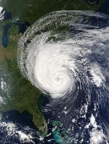
The effects of Hurricane Isabel on North Carolina were the worst from a hurricane since Hurricane Floyd
made landfall
in 1999. Hurricane Isabel
formed from a tropical wave
on September 6, 2003 in the tropical Atlantic Ocean
. It moved northwestward, and within an environment of light wind shear and warm waters it steadily strengthened to reach peak winds of 165 mph (265 km/h) on September 11. After fluctuating in intensity for four days, Isabel gradually weakened and made landfall on the Outer Banks
of North Carolina
with winds of 105 mph (165 km/h) on September 18. It quickly weakened over land and became extratropical
over western Pennsylvania
the next day.
Isabel produced moderate to heavy damage across eastern North Carolina, totaling $450 million (2003 USD
, ($ USD). Damage was heaviest in Dare County
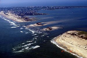
, where storm surge flooding and strong winds damaged thousands of houses. The storm surge produced a 2,000 foot (600 m) wide inlet on Hatteras Island
, isolating Hatteras
by road for two months. Strong winds downed hundreds of trees of across the state, leaving up to 700,000 residents without power. Most areas with power outages had power restored within a few days. The hurricane directly killed one person and indirectly killed two in the state.
 By four days before Isabel made landfall, most computer models
predicted Isabel to make landfall between North Carolina and New Jersey
, and the National Hurricane Center
consistently forecast a landfall on North Carolina. Initially, forecasters predicted a landfall in the northeastern portion of the state, though as the hurricane neared land the predicted landfall position was much closer to where it ultimately was. From three days in advance, the average track forecast error for its landfall was only 36 miles (58 km), and for 48 hours in advance the average track error was 18 miles (29 km). Strong confidence in Isabel's final landfall prompted the National Hurricane Center to issue a hurricane watch
for the entire North Carolina coastline about 50 hours before Isabel struck land. 38 hours before the hurricane made landfall, the National Hurricane Center upgraded the watch to a hurricane warning for the landfall area. The Newport
Weather Forecast Office
issued a flood potential statement two days before landfall, which indicated a threat for flash flooding. The office began preparing for the hurricane one week before landfall, and brought additional staff members to assist with hurricane related duties.
Evacuation
orders began on September 16, when officials issued a voluntary evacuation for portions of four counties and one entire county. By around 24 hours before landfall, mandatory evacuations were ordered for eight counties, all of which but one were for the entire counties. All coastal counties from Cape Fear northward were under a mandatory evacuation. A survey of 603 residents in northeastern North Carolina indicated 57% of residents along the Outer Banks and 77% of residents in storm surge
-prone areas of the Pamlico Sound
did not evacuate despite being under a mandatory evacuation. The two primary reasons stated for the residents' evacuation decisions were the hurricane's strength and track. The media and statements from officials were two other reasons. 70% of people along the Outer Banks heard the official evacuation notices, though only 30% of residents near the Pamlico Sound heard the notices. A majority of the respondents to the survey who heard the evacuation notices left the area. None of the surveyed evacuees from the Outer Banks went to a public shelter; 60% went to a friend or a relative's house and 24% went to a motel. Evacuees on the Outer Banks generally went elsewhere in North Carolina or to Virginia
. For evacuees around the Pamlico Sound, only 9% left for a public shelter, while 75% left for a friend or relative's house. Most near the Pamlico Sound remained in their own neighborhood or own county. Of the 19 North Carolina counties issuing evacuation orders, the duration of the evacuation process varied between 3 hours to 12 hours in Dare County. Five counties reported heavy amounts of traffic, while traffic problems included stalled cars along roads, inadequate route signing, and flooded or damaged roads.
By the morning of the hurricane's landfall, 65 shelters were prepared with a capacity of 95,000 people. The American Red Cross
prepared 100 feeding vehicles in staging areas, and deployed two mobile kitchens each with the capacity to provide 10,000 meals per day. Additionally, five Southern Baptist Convention
kitchens were on standby, in total being able to provide 20,000 meals per day.
 Hurricane Isabel produced hurricane force wind gusts throughout eastern North Carolina. The winds downed hundreds of trees, leaving up to 700,000 without power across the state. Damage from the hurricane totaled about $450 million (2003 USD, ($ USD)). Three people were killed in the state, two due to falling trees and one due to a utility worker attempting to restore electricity.
 Hurricane Isabel first began affecting North Carolina about 15 hours before it struck land. Upon making landfall along the Outer Banks, the hurricane produced strong waves of 15 to 25 feet (4.5 to 6 m) in height and a storm surge of about 6 to 8 feet (1.8 to 2.4 m). Waters reached a height of 7.15 feet (2.2 m) in Hatteras. Storm tides along the coast peaked at 7.7 feet (2.3 m) in Cape Hatteras
, though the total could be higher there due to the tide gage being destroyed by the hurricane. The surge and waves created a new inlet
by washing out a portion of Hatteras Island between Hatteras and Frisco
. Unofficially named Isabel Inlet
, the break was 2,000 feet (600 m) wide and 15 feet (5 m) deep, and consisted of three distinct channels. The formation of the inlet destroyed a portion of North Carolina Highway 12, and also washed out three homes, dunes, power lines, and utility pipes. The new inlet destroyed all utility connections to Hatteras Village, isolating the residents there. The storm surge and waves from Isabel also resulted in a breach between Hatteras and Hatteras Inlet
. The breach, which nearly became an inlet, formed from the flow of ocean water across the island, though it was not deep enough for a constant water flow. The breach occurred in an area without roads or houses, and had little impact on Hatteras residents. Rough surf and storm surge caused overwash and severe beach erosion throughout the Outer Banks, with flooding in Ocracoke
reportedly being up to waist-high. The hurricane produced an estimated 4 inches (100 mm) of rain throughout most of the Outer Banks, with Duck reporting a peak of 4.72 inches (120 mm). Wind gusts in association with the hurricane peaked at 105 mph (170 km/h) in Ocracoke, with several other locations reporting hurricane force gusts.
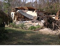
Wind and water damage across the Outer Banks was extensive. Strong waves and the storm surge from Hurricane Isabel knocked about 30 to 40 houses and several motels off of their pilings. Two families who did not evacuate were nearly swept out to sea when their home was destroyed. Local rescue was unable to reach them; however, they were ultimately able to reach safety. The rough waves greatly affected piers in Nags Head
, Rodanthe
, and Frisco, with three being completely destroyed. Several locations along North Carolina Highway 12 were partially washed out or covered with debris, and 15 foot (4.5 m) sections of pavement on both sides of a bridge near Ocracoke were washed away. Strong waves destroyed a beach access ramp, as well. Several thousand homes and businesses were damaged by the passage of the hurricane, and damage in Dare County totalled nearly $350 million (2003 USD, ($ USD)). In the Outer Banks, no deaths or injuries were reported.
.jpg) The effects of Hurricane Isabel were generally light in the southeastern portion of the state. Sustained winds reached 72 mph (116 km/h) offshore in the Frying Pan Shoals
The effects of Hurricane Isabel were generally light in the southeastern portion of the state. Sustained winds reached 72 mph (116 km/h) offshore in the Frying Pan Shoals
, where a gust of 82 mph (132 km/h) was also reported. Sustained winds were lighter along the coast, peaking at 45 mph (72 km/h) at the Wilmington International Airport
, while gusts reached 66 mph (106 km/h) at a North Carolina State Ports Authority
facility in Wilmington
. Tropical storm force wind gusts were reported as far inland as Lumberton
, where gusts reached 52 mph (54 km/h). The large circulation of Isabel dropped moderate rainfall across the area, peaking at 4.51 inches (115 mm) in Whiteville
. Additionally, weather radars estimated over 5 inches (125 mm) of precipitation fell in portions of New Hanover County
. The rainfall resulted in ponding on roadways, though no severe flooding was reported. Storm tides were generally around 1 foot (0.3 m) above normal, though Wilmington reported a storm tide of 3.22 feet (1 m). Rough waves resulted in moderate beach erosion near Cape Fear and minor erosion along eastward-facing beaches north of Cape Fear.
Damage was minor in southeast North Carolina. Moderate winds inflicted isolated shingle and siding damage along barrier islands. The winds downed several trees, some onto cars and houses. Brief power outages were also reported. Beach erosion damaged a bridge in Bald Head Island
, as well. In Chowan County
, a business parking lot was under several feet of water due to flash flooding. One person was indirectly killed in Carteret County
when trying to restore electricity.
 Isabel produced strong winds throughout inland areas of eastern North Carolina. Plymouth
, located 75 miles (120 km) from where the hurricane made landfall, reported gusts to 95 mph (155 km/h). Sustained winds were lighter, with only a few locations receiving tropical storm strength winds. The passage of the hurricane resulted in moderate rainfall of up to 6.02 inches (153 mm) in Havelock
. Upon making landfall, Isabel produced moderate to severe storm surges along the Pamlico
and Neuse River
s, with a location in Craven County
reporting a storm tide of 10.5 feet (3.2 m) above normal.
The strong storm surge produced significant flooding in Harlowe and Oriental
. Several other locations also reported flooding of streets and low-lying areas. The rise of water flooded many homes in Craven County and the eastern portions of Carteret and Pamlico
counties. Emergency personnel performed many rescues to people who had not evacuated and had become trapped by storm surge flooding. Several eyewitnesses reported high velocity, waist deep water moving homes, trailers, and other objects many yards inland. As the water retreated, these objects were then dragged back towards the sound. A 5 to 8 foot (1.5 to 2.4 m) storm surge struck the western portion of the Albemarle Sound
, with significant surge flooding occurring to the west of Edenton. There, the surge destroyed four homes, two of which were moved up to 20 feet (6.1 m) off their concrete block foundations. Nearly 60 percent of all homes and business in Chowan County suffered some structural damage due to wind, many of which were the result of large falling trees. One female died when a tree fell on her vehicle in Chowan County.
 Hundreds of residents were stranded in Hatteras following the formation of the new inlet created by rising waters. Many parts of North Carolina Highway 12 were partially washed or damaged, which slowed recovery efforts and the return of homeowners in the Outer Banks. Sections of the highway were closed to one lane. The ferry between Hatteras Island
and Ocracoke Island was temporarily closed due to damage after the hurricane, though a small passenger ferry remained available for Hatteras Village residents and emergency workers. People who were not residents were not allowed to be on the Outer Banks for two weeks after the hurricane due to damaged road conditions. When visitors were allowed to return, many ventured to see the new inlet, despite a 1 mile (1.6 km) walk from the nearest road.
Initially, long-term solutions to the Isabel Inlet such as building a bridge or a ferry system were considered, though they were ultimately cancelled in favor of pumping sand and filling the inlet. Coastal geologists were opposed to the solution, stating the evolution of the Outer Banks is dependent on inlets from hurricanes. Dredging operations began on October 17, about a month after the hurricane struck. The United States Geological Survey
used sand from the ferry channel to the southwest of Hatteras Island, a choice made to minimize impact to submerged aquatic vegetation and due to the channel being filled somewhat during the hurricane. On November 22, about two months after the hurricane struck, Highway 12 and Hatteras Island were reopened to public access. On the same day, the ferry between Hatteras and Ocracoke was reopened. The breach on the southern end of Hatteras Island was filled in with sand, as well.
Hardware stores experienced great demand for portable generators, chain saws, dehumidifiers, and air movers following the passage of the hurricane. Utility crews from across the country came to the state to assist in returning power, though power outages persisted for several days. Over 2,500 utility members worked, in some cases around the clock, to restore the power. One power company restored power to 68% of its affects customers by the day after Isabel passed through the area. By four days after landfall, 83,000 customers were without power, down from its peak of several hundred thousand.
 Hours after Isabel made landfall, President
George W. Bush
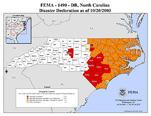
issued a major disaster declaration for 26 North Carolina counties, which allowed the use of federal personnel, equipment and lifesaving systems and the delivery of heavy-duty generators, plastic sheeting, tents, cots, food, water, medical aid and other essential supplies and materials for sustaining human life. The declaration also allocated federal funds for the long-term recovery of hurricane-stricken residents and business owners, as well as providing federal funds for the state and local governments to pay 75 percent of the eligible cost for debris removal and emergency services related to the hurricane, including requested emergency work undertaken by the federal government. By four days after the emergency declaration, assistance checks were mailed and used by residents to pay for what was not covered by their insurance.
By four days after landfall, FEMA
served around 68,000 meals to displaced families. More than a dozen disaster recovery centers were initiated throughout the state. FEMA provided 125,000 pounds of ice in the first few days, and prepared 200,000 pounds of ice and 180,000 liters of water for the following week for the remaining communities without water. By six days after Isabel struck the state, all hospitals were opened and all roads excluding North Carolina Highway 12 were passable due to emergency crews clearing roads with debris. By about one month after the hurricane struck, 32,560 North Carolina residents applied for federal assistance, with disaster aid totaling about $50 million (2003 USD, ($ USD). Subsequent disaster declarations ultimately declared 47 North Carolina counties as disaster areas. By 12 weeks after the hurricane passed through the state, 54,425 residents applied for federal assistance, with disaster aid totaling $155.2 million (2003 USD, ($ USD).
Hurricane Floyd
Hurricane Floyd was the sixth named storm, fourth hurricane, and third major hurricane in the 1999 Atlantic hurricane season. Floyd triggered the third largest evacuation in US history when 2.6 million coastal residents of five states were ordered from their homes as it approached...
made landfall
Landfall (meteorology)
Landfall is the event of a tropical cyclone or a waterspout coming onto land after being over water. When a waterspout makes landfall it is reclassified as a tornado, which can then cause damage inland...
in 1999. Hurricane Isabel
Hurricane Isabel
Hurricane Isabel was the costliest and deadliest hurricane in the 2003 Atlantic hurricane season. The ninth named storm, fifth hurricane, and second major hurricane of the season, Isabel formed near the Cape Verde Islands from a tropical wave on September 6 in the tropical Atlantic Ocean...
formed from a tropical wave
Tropical wave
Tropical waves, easterly waves, or tropical easterly waves, also known as African easterly waves in the Atlantic region, are a type of atmospheric trough, an elongated area of relatively low air pressure, oriented north to south, which move from east to west across the tropics causing areas of...
on September 6, 2003 in the tropical Atlantic Ocean
Atlantic Ocean
The Atlantic Ocean is the second-largest of the world's oceanic divisions. With a total area of about , it covers approximately 20% of the Earth's surface and about 26% of its water surface area...
. It moved northwestward, and within an environment of light wind shear and warm waters it steadily strengthened to reach peak winds of 165 mph (265 km/h) on September 11. After fluctuating in intensity for four days, Isabel gradually weakened and made landfall on the Outer Banks
Outer Banks
The Outer Banks is a 200-mile long string of narrow barrier islands off the coast of North Carolina, beginning in the southeastern corner of Virginia Beach on the east coast of the United States....
of North Carolina
North Carolina
North Carolina is a state located in the southeastern United States. The state borders South Carolina and Georgia to the south, Tennessee to the west and Virginia to the north. North Carolina contains 100 counties. Its capital is Raleigh, and its largest city is Charlotte...
with winds of 105 mph (165 km/h) on September 18. It quickly weakened over land and became extratropical
Extratropical cyclone
Extratropical cyclones, sometimes called mid-latitude cyclones or wave cyclones, are a group of cyclones defined as synoptic scale low pressure weather systems that occur in the middle latitudes of the Earth having neither tropical nor polar characteristics, and are connected with fronts and...
over western Pennsylvania
Pennsylvania
The Commonwealth of Pennsylvania is a U.S. state that is located in the Northeastern and Mid-Atlantic regions of the United States. The state borders Delaware and Maryland to the south, West Virginia to the southwest, Ohio to the west, New York and Ontario, Canada, to the north, and New Jersey to...
the next day.
Isabel produced moderate to heavy damage across eastern North Carolina, totaling $450 million (2003 USD
United States dollar
The United States dollar , also referred to as the American dollar, is the official currency of the United States of America. It is divided into 100 smaller units called cents or pennies....
, ($ USD). Damage was heaviest in Dare County
Dare County, North Carolina
-National protected areas:* Alligator River National Wildlife Refuge * Cape Hatteras National Seashore * Fort Raleigh National Historic Site* Pea Island National Wildlife Refuge* Wright Brothers National Memorial-Demographics:...
, where storm surge flooding and strong winds damaged thousands of houses. The storm surge produced a 2,000 foot (600 m) wide inlet on Hatteras Island
Hatteras Island
Hatteras Island is a barrier island located off the North Carolina coast. Dividing the Atlantic Ocean and the Pamlico Sound, it runs parallel to the coast, forming a bend at Cape Hatteras. It is part of North Carolina's Outer Banks and includes the towns of Rodanthe, Waves, Salvo, Avon, Buxton,...
, isolating Hatteras
Hatteras, North Carolina
Hatteras is an unincorporated community in Dare County, North Carolina, United States, on the Outer Banks island of Hatteras. North Carolina Highway 12 passes through the community linking it to Frisco and Ocracoke . It is south of the famous Cape Hatteras and the Cape Hatteras Lighthouse in Buxton...
by road for two months. Strong winds downed hundreds of trees of across the state, leaving up to 700,000 residents without power. Most areas with power outages had power restored within a few days. The hurricane directly killed one person and indirectly killed two in the state.
Preparations
Global climate model
A General Circulation Model is a mathematical model of the general circulation of a planetary atmosphere or ocean and based on the Navier–Stokes equations on a rotating sphere with thermodynamic terms for various energy sources . These equations are the basis for complex computer programs commonly...
predicted Isabel to make landfall between North Carolina and New Jersey
New Jersey
New Jersey is a state in the Northeastern and Middle Atlantic regions of the United States. , its population was 8,791,894. It is bordered on the north and east by the state of New York, on the southeast and south by the Atlantic Ocean, on the west by Pennsylvania and on the southwest by Delaware...
, and the National Hurricane Center
National Hurricane Center
The National Hurricane Center , located at Florida International University in Miami, Florida, is the division of the National Weather Service responsible for tracking and predicting weather systems within the tropics between the Prime Meridian and the 140th meridian west poleward to the 30th...
consistently forecast a landfall on North Carolina. Initially, forecasters predicted a landfall in the northeastern portion of the state, though as the hurricane neared land the predicted landfall position was much closer to where it ultimately was. From three days in advance, the average track forecast error for its landfall was only 36 miles (58 km), and for 48 hours in advance the average track error was 18 miles (29 km). Strong confidence in Isabel's final landfall prompted the National Hurricane Center to issue a hurricane watch
Tropical cyclone warnings and watches
Warnings and watches are two levels of alert issued by national weather forecasting bodies to coastal areas threatened by the imminent approach of a tropical cyclone of tropical storm or hurricane intensity. They are notices to the local population and civil authorities to make appropriate...
for the entire North Carolina coastline about 50 hours before Isabel struck land. 38 hours before the hurricane made landfall, the National Hurricane Center upgraded the watch to a hurricane warning for the landfall area. The Newport
Newport, North Carolina
Newport is a town in Carteret County, North Carolina, United States. The population was 3,349 at the 2000 census.-History:Newport was officially chartered in 1866. Although the crossroads community on the Newport River was known by that name decades earlier, the area was also known as Bell's Corner...
Weather Forecast Office
National Weather Service
The National Weather Service , once known as the Weather Bureau, is one of the six scientific agencies that make up the National Oceanic and Atmospheric Administration of the United States government...
issued a flood potential statement two days before landfall, which indicated a threat for flash flooding. The office began preparing for the hurricane one week before landfall, and brought additional staff members to assist with hurricane related duties.
Evacuation
Emergency evacuation
Emergency evacuation is the immediate and rapid movement of people away from the threat or actual occurrence of a hazard. Examples range from the small scale evacuation of a building due to a bomb threat or fire to the large scale evacuation of a district because of a flood, bombardment or...
orders began on September 16, when officials issued a voluntary evacuation for portions of four counties and one entire county. By around 24 hours before landfall, mandatory evacuations were ordered for eight counties, all of which but one were for the entire counties. All coastal counties from Cape Fear northward were under a mandatory evacuation. A survey of 603 residents in northeastern North Carolina indicated 57% of residents along the Outer Banks and 77% of residents in storm surge
Storm surge
A storm surge is an offshore rise of water associated with a low pressure weather system, typically tropical cyclones and strong extratropical cyclones. Storm surges are caused primarily by high winds pushing on the ocean's surface. The wind causes the water to pile up higher than the ordinary sea...
-prone areas of the Pamlico Sound
Pamlico Sound
Pamlico Sound in North Carolina, is the largest lagoon along the U.S. East Coast, being long and 24 to 48 km wide. It is a body of water separated from the Atlantic Ocean by the Outer Banks, a row of low, sandy barrier islands, including Cape Hatteras. The Neuse and Pamlico rivers flow in...
did not evacuate despite being under a mandatory evacuation. The two primary reasons stated for the residents' evacuation decisions were the hurricane's strength and track. The media and statements from officials were two other reasons. 70% of people along the Outer Banks heard the official evacuation notices, though only 30% of residents near the Pamlico Sound heard the notices. A majority of the respondents to the survey who heard the evacuation notices left the area. None of the surveyed evacuees from the Outer Banks went to a public shelter; 60% went to a friend or a relative's house and 24% went to a motel. Evacuees on the Outer Banks generally went elsewhere in North Carolina or to Virginia
Virginia
The Commonwealth of Virginia , is a U.S. state on the Atlantic Coast of the Southern United States. Virginia is nicknamed the "Old Dominion" and sometimes the "Mother of Presidents" after the eight U.S. presidents born there...
. For evacuees around the Pamlico Sound, only 9% left for a public shelter, while 75% left for a friend or relative's house. Most near the Pamlico Sound remained in their own neighborhood or own county. Of the 19 North Carolina counties issuing evacuation orders, the duration of the evacuation process varied between 3 hours to 12 hours in Dare County. Five counties reported heavy amounts of traffic, while traffic problems included stalled cars along roads, inadequate route signing, and flooded or damaged roads.
By the morning of the hurricane's landfall, 65 shelters were prepared with a capacity of 95,000 people. The American Red Cross
American Red Cross
The American Red Cross , also known as the American National Red Cross, is a volunteer-led, humanitarian organization that provides emergency assistance, disaster relief and education inside the United States. It is the designated U.S...
prepared 100 feeding vehicles in staging areas, and deployed two mobile kitchens each with the capacity to provide 10,000 meals per day. Additionally, five Southern Baptist Convention
Southern Baptist Convention
The Southern Baptist Convention is a United States-based Christian denomination. It is the world's largest Baptist denomination and the largest Protestant body in the United States, with over 16 million members...
kitchens were on standby, in total being able to provide 20,000 meals per day.
Impact
Outer Banks
Cape Hatteras
Cape Hatteras is a cape on the coast of North Carolina. It is the point that protrudes the farthest to the southeast along the northeast-to-southwest line of the Atlantic coast of North America...
, though the total could be higher there due to the tide gage being destroyed by the hurricane. The surge and waves created a new inlet
Inlet
An inlet is a narrow body of water between islands or leading inland from a larger body of water, often leading to an enclosed body of water, such as a sound, bay, lagoon or marsh. In sea coasts an inlet usually refers to the actual connection between a bay and the ocean and is often called an...
by washing out a portion of Hatteras Island between Hatteras and Frisco
Frisco, North Carolina
Frisco is a small unincorporated community on the barrier island of Hatteras Island, between the villages of Buxton and Hatteras. It is located in Dare County, North Carolina, USA, and was previously named Trent, or Trent Woods, but received a new name with the coming of the post office in 1898...
. Unofficially named Isabel Inlet
Isabel Inlet
Isabel Inlet was an informally named inlet along the Outer Banks of North Carolina. It was created by Hurricane Isabel when it swept ashore on September 18, 2003....
, the break was 2,000 feet (600 m) wide and 15 feet (5 m) deep, and consisted of three distinct channels. The formation of the inlet destroyed a portion of North Carolina Highway 12, and also washed out three homes, dunes, power lines, and utility pipes. The new inlet destroyed all utility connections to Hatteras Village, isolating the residents there. The storm surge and waves from Isabel also resulted in a breach between Hatteras and Hatteras Inlet
Hatteras Inlet
Hatteras Inlet is a estuary in North Carolina, located along the Outer Banks, separating Hatteras Island and Ocracoke Island. It connects the Atlantic Ocean to the Pamlico Sound. Hatteras Inlet is located entirely within Hyde County.- History :...
. The breach, which nearly became an inlet, formed from the flow of ocean water across the island, though it was not deep enough for a constant water flow. The breach occurred in an area without roads or houses, and had little impact on Hatteras residents. Rough surf and storm surge caused overwash and severe beach erosion throughout the Outer Banks, with flooding in Ocracoke
Ocracoke, North Carolina
Ocracoke is a census-designated place and unincorporated town located at the southern end of Ocracoke Island, located entirely within Hyde County, North Carolina. The population was 769 as of the 2000 census...
reportedly being up to waist-high. The hurricane produced an estimated 4 inches (100 mm) of rain throughout most of the Outer Banks, with Duck reporting a peak of 4.72 inches (120 mm). Wind gusts in association with the hurricane peaked at 105 mph (170 km/h) in Ocracoke, with several other locations reporting hurricane force gusts.
Wind and water damage across the Outer Banks was extensive. Strong waves and the storm surge from Hurricane Isabel knocked about 30 to 40 houses and several motels off of their pilings. Two families who did not evacuate were nearly swept out to sea when their home was destroyed. Local rescue was unable to reach them; however, they were ultimately able to reach safety. The rough waves greatly affected piers in Nags Head
Nags Head, North Carolina
Nags Head is a town in Dare County, North Carolina, United States. The population was 2,700 at the 2000 census.-History:Early maps of the area show Nags Head as a promontory of land characterized by high sand dunes visible from miles at sea...
, Rodanthe
Rodanthe, North Carolina
Rodanthe is an unincorporated community located in Dare County, North Carolina, on Hatteras Island, part of North Carolina's Outer Banks. Rodanthe, along with Waves and Salvo, are part of the settlement of Chicamacomico...
, and Frisco, with three being completely destroyed. Several locations along North Carolina Highway 12 were partially washed out or covered with debris, and 15 foot (4.5 m) sections of pavement on both sides of a bridge near Ocracoke were washed away. Strong waves destroyed a beach access ramp, as well. Several thousand homes and businesses were damaged by the passage of the hurricane, and damage in Dare County totalled nearly $350 million (2003 USD, ($ USD)). In the Outer Banks, no deaths or injuries were reported.
Southeast North Carolina
Frying Pan Shoals
The Frying Pan Shoals are a long, shifting area of shoals off the coast of Cape Fear in North Carolina, United States. The shoals have been a hazard to ships in the area since the beginning of European exploration of the area; the area is littered with shipwrecks. The southern edge of the shoals...
, where a gust of 82 mph (132 km/h) was also reported. Sustained winds were lighter along the coast, peaking at 45 mph (72 km/h) at the Wilmington International Airport
Wilmington International Airport
-Other operations:As of August 2011, Wilmington International Airport has 134 aircraft that are based at the Airport. There are 100 single engine aircraft, 27 multi-engine aircraft, 7 jet engine aircraft, and 3 helicopters...
, while gusts reached 66 mph (106 km/h) at a North Carolina State Ports Authority
North Carolina State Ports Authority
The North Carolina State Ports Authority is an authority set up by the state of North Carolina to develop and operate seaports in Wilmington and Morehead City, two inland container facilities, one in Charlotte and one in Greensboro, and a marina in Southport. It is planning a large international...
facility in Wilmington
Wilmington, North Carolina
Wilmington is a port city in and is the county seat of New Hanover County, North Carolina, United States. The population is 106,476 according to the 2010 Census, making it the eighth most populous city in the state of North Carolina...
. Tropical storm force wind gusts were reported as far inland as Lumberton
Lumberton, North Carolina
Lumberton is a city in Robeson County, North Carolina, United States. The population was 20,795 at the 2000 census. It is the county seat of Robeson County. Lumberton, located in southern North Carolina's Inner Banks region, is located on the Lumber River...
, where gusts reached 52 mph (54 km/h). The large circulation of Isabel dropped moderate rainfall across the area, peaking at 4.51 inches (115 mm) in Whiteville
Whiteville, North Carolina
Whiteville is a city in Columbus County, North Carolina, United States. The population was 5,148 at the 2000 census. It is the only city of Columbus County and is the county seat....
. Additionally, weather radars estimated over 5 inches (125 mm) of precipitation fell in portions of New Hanover County
New Hanover County, North Carolina
-Demographics:As of the census of 2000, there were 160,307 people, 68,183 households, and 41,591 families residing in the county. The population density was 806 people per square mile . There were 79,616 housing units at an average density of 400 per square mile...
. The rainfall resulted in ponding on roadways, though no severe flooding was reported. Storm tides were generally around 1 foot (0.3 m) above normal, though Wilmington reported a storm tide of 3.22 feet (1 m). Rough waves resulted in moderate beach erosion near Cape Fear and minor erosion along eastward-facing beaches north of Cape Fear.
Damage was minor in southeast North Carolina. Moderate winds inflicted isolated shingle and siding damage along barrier islands. The winds downed several trees, some onto cars and houses. Brief power outages were also reported. Beach erosion damaged a bridge in Bald Head Island
Bald Head Island, North Carolina
Bald Head Island is a village located on the east side of the Cape Fear River in Brunswick County, North Carolina, United States. Compared to the city of Wilmington to the north, the village of Bald Head Island is small and somewhat remote. It is only accessible by ferry from the nearby town of...
, as well. In Chowan County
Chowan County, North Carolina
- Law and government :Chowan County is a member of the Albemarle Commission regional council of government-Demographics:As of the census of 2010, there were 14,793 people, 5,580 households, and 4,006 families residing in the county. The population density was 84 people per square mile . There...
, a business parking lot was under several feet of water due to flash flooding. One person was indirectly killed in Carteret County
Carteret County, North Carolina
Carteret County is a county located in the U.S. state of North Carolina. As of 2010, the population was 66,469. Its county seat is Beaufort. Most of the county is part of the Crystal Coast....
when trying to restore electricity.
Inland
Plymouth, North Carolina
Plymouth is the largest town in Washington County, North Carolina, United States. The population was 4,107 at the 2000 census. It is the county seat of Washington County...
, located 75 miles (120 km) from where the hurricane made landfall, reported gusts to 95 mph (155 km/h). Sustained winds were lighter, with only a few locations receiving tropical storm strength winds. The passage of the hurricane resulted in moderate rainfall of up to 6.02 inches (153 mm) in Havelock
Havelock, North Carolina
Havelock is a city in Craven County, North Carolina, United States. The population was 22,442 at the 2000 census, and estimated to be 21,906 in 2006...
. Upon making landfall, Isabel produced moderate to severe storm surges along the Pamlico
Pamlico River
The Pamlico River is a tidal river that flows into Pamlico Sound, in North Carolina in the United States of America. It is formed by the confluence of the Tar River and Tranters Creek....
and Neuse River
Neuse River
The Neuse River is a river rising in the Piedmont of North Carolina and emptying into Pamlico Sound below New Bern. Its total length is approximately , making it the longest river entirely contained in North Carolina. The Trent River joins it at New Bern. Its drainage basin, measuring in area,...
s, with a location in Craven County
Craven County, North Carolina
Craven County is a county located in the U.S. state of North Carolina. The estimated population in 2006 was 94,875. Its county seat is New Bern.Craven County is part of the New Bern, North Carolina, Micropolitan Statistical Area.-History:...
reporting a storm tide of 10.5 feet (3.2 m) above normal.
The strong storm surge produced significant flooding in Harlowe and Oriental
Oriental, North Carolina
Oriental is known as 'The Sailing Capital of North Carolina'.This tiny harbor town is on the Neuse River, the widest river in the USA, leading to the vast sailing waters of Pamlico Sound and on to the Atlantic through North Carolina's barrier islands. The area is easily some of the finest boating...
. Several other locations also reported flooding of streets and low-lying areas. The rise of water flooded many homes in Craven County and the eastern portions of Carteret and Pamlico
Pamlico County, North Carolina
-Demographics:As of the census of 2000, there were 12,934 people, 5,178 households, and 3,717 families residing in the county. The population density was 38 people per square mile . There were 6,781 housing units at an average density of 20 per square mile...
counties. Emergency personnel performed many rescues to people who had not evacuated and had become trapped by storm surge flooding. Several eyewitnesses reported high velocity, waist deep water moving homes, trailers, and other objects many yards inland. As the water retreated, these objects were then dragged back towards the sound. A 5 to 8 foot (1.5 to 2.4 m) storm surge struck the western portion of the Albemarle Sound
Albemarle Sound
Albemarle Sound is a large estuary on the coast of North Carolina in the United States located at the confluence of a group of rivers, including the Chowan and Roanoke. It is separated from the Atlantic Ocean by the Outer Banks, a long barrier peninsula upon which the town of Kitty Hawk is located,...
, with significant surge flooding occurring to the west of Edenton. There, the surge destroyed four homes, two of which were moved up to 20 feet (6.1 m) off their concrete block foundations. Nearly 60 percent of all homes and business in Chowan County suffered some structural damage due to wind, many of which were the result of large falling trees. One female died when a tree fell on her vehicle in Chowan County.
Aftermath
Hatteras Island
Hatteras Island is a barrier island located off the North Carolina coast. Dividing the Atlantic Ocean and the Pamlico Sound, it runs parallel to the coast, forming a bend at Cape Hatteras. It is part of North Carolina's Outer Banks and includes the towns of Rodanthe, Waves, Salvo, Avon, Buxton,...
and Ocracoke Island was temporarily closed due to damage after the hurricane, though a small passenger ferry remained available for Hatteras Village residents and emergency workers. People who were not residents were not allowed to be on the Outer Banks for two weeks after the hurricane due to damaged road conditions. When visitors were allowed to return, many ventured to see the new inlet, despite a 1 mile (1.6 km) walk from the nearest road.
Initially, long-term solutions to the Isabel Inlet such as building a bridge or a ferry system were considered, though they were ultimately cancelled in favor of pumping sand and filling the inlet. Coastal geologists were opposed to the solution, stating the evolution of the Outer Banks is dependent on inlets from hurricanes. Dredging operations began on October 17, about a month after the hurricane struck. The United States Geological Survey
United States Geological Survey
The United States Geological Survey is a scientific agency of the United States government. The scientists of the USGS study the landscape of the United States, its natural resources, and the natural hazards that threaten it. The organization has four major science disciplines, concerning biology,...
used sand from the ferry channel to the southwest of Hatteras Island, a choice made to minimize impact to submerged aquatic vegetation and due to the channel being filled somewhat during the hurricane. On November 22, about two months after the hurricane struck, Highway 12 and Hatteras Island were reopened to public access. On the same day, the ferry between Hatteras and Ocracoke was reopened. The breach on the southern end of Hatteras Island was filled in with sand, as well.
Hardware stores experienced great demand for portable generators, chain saws, dehumidifiers, and air movers following the passage of the hurricane. Utility crews from across the country came to the state to assist in returning power, though power outages persisted for several days. Over 2,500 utility members worked, in some cases around the clock, to restore the power. One power company restored power to 68% of its affects customers by the day after Isabel passed through the area. By four days after landfall, 83,000 customers were without power, down from its peak of several hundred thousand.
President of the United States
The President of the United States of America is the head of state and head of government of the United States. The president leads the executive branch of the federal government and is the commander-in-chief of the United States Armed Forces....
George W. Bush
George W. Bush
George Walker Bush is an American politician who served as the 43rd President of the United States, from 2001 to 2009. Before that, he was the 46th Governor of Texas, having served from 1995 to 2000....
issued a major disaster declaration for 26 North Carolina counties, which allowed the use of federal personnel, equipment and lifesaving systems and the delivery of heavy-duty generators, plastic sheeting, tents, cots, food, water, medical aid and other essential supplies and materials for sustaining human life. The declaration also allocated federal funds for the long-term recovery of hurricane-stricken residents and business owners, as well as providing federal funds for the state and local governments to pay 75 percent of the eligible cost for debris removal and emergency services related to the hurricane, including requested emergency work undertaken by the federal government. By four days after the emergency declaration, assistance checks were mailed and used by residents to pay for what was not covered by their insurance.
By four days after landfall, FEMA
Federal Emergency Management Agency
The Federal Emergency Management Agency is an agency of the United States Department of Homeland Security, initially created by Presidential Reorganization Plan No. 1 of 1978 and implemented by two Executive Orders...
served around 68,000 meals to displaced families. More than a dozen disaster recovery centers were initiated throughout the state. FEMA provided 125,000 pounds of ice in the first few days, and prepared 200,000 pounds of ice and 180,000 liters of water for the following week for the remaining communities without water. By six days after Isabel struck the state, all hospitals were opened and all roads excluding North Carolina Highway 12 were passable due to emergency crews clearing roads with debris. By about one month after the hurricane struck, 32,560 North Carolina residents applied for federal assistance, with disaster aid totaling about $50 million (2003 USD, ($ USD). Subsequent disaster declarations ultimately declared 47 North Carolina counties as disaster areas. By 12 weeks after the hurricane passed through the state, 54,425 residents applied for federal assistance, with disaster aid totaling $155.2 million (2003 USD, ($ USD).
See also
- List of Atlantic hurricanes
- List of retired Atlantic hurricane names
- List of North Carolina hurricanes (2000-present)