
Dufourspitze
Encyclopedia
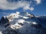
Monte Rosa is the highest mountain of Switzerland
, the second highest both of the Alps
and western Europe
. Distinguished by the name Dufourspitze, its 4634 m (15,203 ft) summit is the culminating point of the Pennine Alps
. Although its main peak is located within Switzerland in the southeastern part of the canton of Valais
, the Monte Rosa Massif is the second highest massif
in Italy
.
The Gorner Glacier descends in gentle slopes on the western side of Monte Rosa and flows towards Zermatt
. On the east a 2,400 metre high wall towers above the village of Macugnaga
.
Following a long series of attempts beginning in the early nineteenth century Monte Rosa's summit was first reached in 1855 from Zermatt by a party of eight climbers led by three guides.
Each summer a large number of climbers set out from the Monte Rosa Hut
on the mountain's west side for the summit via the normal route. Many tourists come each year to Zermatt to see the panorama that extends over the giants of the Swiss Alps
from Monte Rosa to the Matterhorn
.
.png) The name Monte Rosa comes from Italian
The name Monte Rosa comes from Italian
, however rosa is derived from the Franco-Provençal dialect
word rouese meaning "glacier". On old maps as late as 1740, the mountain was named Monte Bosa and even Monte Biosa by the inhabitants of Val Sesia. The name Mon Boso which appears in Leonardo da Vinci
's notebooks very likely designated the same mountain. From Zermatt the mountain was formerly known under the name Gornerhorn (in German, lit. Large mountain). The name gorner is still used for the western ridge that is thrown out from the main mass (Gornergrat) and the glacier that lies at its foot (Gornergletscher) but not used for the mountain itself anymore.
The summit is distinguished by the name Dufourspitze (in German, lit. Dufour Peak; Italian: Punta Dufour, French: Pointe Dufour). This replaced the former name Höchste Spitze (in German, lit. Highest Peak) that was indicated on the Swiss maps before the Federal Council
, on January 28, 1863, decided to rename the mountain in honor of Guillaume-Henri Dufour. Dufour was a Swiss engineer, topographer, co-founder of the Red Cross and army officer who led the Sonderbund
campaign. This decision followed the completion of the Dufour Map, a series of military topographical maps created under the command of Dufour.
, Switzerland's lowest point. A recent work (2000), involving universities and the offices of cartography of Italy and Switzerland, was made in order to record a more precise elevation for Monte Rosa. The result was 4635.25 metres (15,208 ft) from the Italian side and 4634.97 metres (15,207 ft) from the Swiss side, with a margin of error
of 0.1 m.
Though the Mediterranean can hardly be visible from the summit of Monte Rosa because of intervening mountains, the view to the south extends to the Apennines
, the mountains of Corsica
and the Maritime Alps
. On the north side the view is limited by the high range of the Bernese Alps
.
Being the highest point in Switzerland, Monte Rosa is also one of the most extreme places. The average air pressure is about half of that of the sea level (56%) and the temperature can reach as low as -40 C. Owing to the frequent prevalence of a high wind from the east or north-east, and the slow pace at which it is possible to move when near the top, precautions against cold are particularly requisite when climbing Monte Rosa. The snow line
is located at about 3,000 metres.
 Monte Rosa lies in the municipality of Zermatt
, on the south-eastern side of the Swiss canton of Valais
. However the mountain lies a little closer to the village of Macugnaga
, on the Italian
eastern side (8 km) than to the village of Zermatt on the western side (12 km). Other inhabited regions close to the massif are the valleys of Alagna
and Gressoney
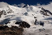
both on the Italian southern side. The west and north side greatly differs from the south and east side. The former is almost completely covered by large glaciers, tributaries of the 57 km² large Gorner Glacier, descending progressively with gentle slopes. Thus the valley is uninhabitated and Zermatt, the first settlement, lies far away from the summit. The latter is a nearly 2.5 km-high wall lying above Macugnaga.
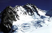
The mountain is mainly covered by eternal snows and glaciers, except for its summit which is a rocky ridge orientated west–east, near to and perpendicular to the main watershed between Switzerland and Italy (Rhône River
and Po River
basins on the Swiss and Italian side respectively). The connecting point between them is the Grenzgipfel
, the highest summit on the Italian side. Thus Monte Rosa is the highest mountain whose summit is not on the main alpine watershed
. The Silbersattel and Grenzsattel are the passes located north and south to the summit. In addition several secondary summits are located close: the Nordend
(4,609 m), the Zumsteinspitze
(4,563 m) and the Signalkuppe
(4,554 m).
Several perpendicular secondary ridges are connected to the main ridge dividing the glaciers that descend towards the Mattertal.The wall connecting the Signalkuppe with the Cima di Jazzi
presents a wall of formidable precipices towards the east, but falls away in a gentle slope to the west. For a breadth of a few kilometres the upper snow-fields lie almost unbroken upon this slope, but as they begin to descend towards the main valley they are divided into two icestreams by a ridge which gradually emerges from the névé, and finally presents a rather bold front to the glaciers on either side. The highest points of this ridge, appearing insignificant by contrast with the grand objects around, is the Stockhorn
and the Gornergrat
. On its south side is the Gorner Glacier, formed by the confluence of all the minor glaciers descending from the north and west sides of the Monte Rosa range, while on the north side the Findel Glacier
descends near to the hamlet of Findeln.
Monte Rosa is one of the high mountains surrounding the 40 km long Matter
valley south of Visp
. On the west are Lyskamm
, Zwillinge, the Breithorn
and the Matterhorn
; on the north are the Weisshorn
and the Dom. The Gornergrat
summit, lying 8 km on the north-west at 3,100 metres, is a popular view point of the massif since it is accessible by train from Zermatt, using the highest open air railway line in Europe.
Because of the low elevation of the mountains to the south, the 2165 m (7,103 ft) prominence of Monte Rosa is well visible from the plains of Lombardy
.
and granite gneiss
(a metamorphic rock
with foliations). The Monte Rosa Nappe lies below the Zermatt-Saas zone
and is part of the Penninic nappes
in the Briançonnais microcontinent
zone, although its paleographic origin is controversial and is sometimes assigned to the Sub-Penninic nappes. Rocks in the paragneiss of the Monte Rosa Nappe record eclogite
-facies metamorphism. The deformation of the Monte Rosa granites indicates a depth of subduction
of about 60 km. They were brought to the surface by tectonic uplift
, which still continues today.
The summit is a sharp, jagged edge of mica schist connected by an arête with the Nordend, but cut off from the Zumsteinspitze to the south by nearly vertical rocks about 400 ft. in height.
can be effected by trekkers in about 10 days. The circuit follows many ancient trails that have linked the Swiss and Italian valleys for centuries. The circuit includes larch forests, alpine meadows, balcony trails and a glacial crossing. It connects seven valleys embracing different cultures: the German speaking high Valais, the originally French speaking and Italian Val d'Aosta and the valleys of Lombardy
and Piedmont
. Good conditions are necessary to circumnavigate the massif. After reaching St. Jacques by the Theodul Pass
and the Col des Cimes Blanches, the trekker crosses the Bettaforca before arriving at Gressoney
. Then two passes must be crossed on the road to Macugnaga, the Col d'Olen and the Colle del Turlo. From Macugnaga the trekker reaches the Saastal
by the Monte Moro
and goes around the Mischabelhörner
before ending his journey in Zermatt. In total six passes between 2700 and 3300 metres must be crossed on a relatively difficult terrain.
into the background of the Madonna of the Rocks or other pictures. Da Vinci explored the Italian side of the mountain and made some observations, though there is but scanty evidence that he had climbed even a minor summit in the neighbourhood. He was intringued by the permanent snow lying on the mountain and the darkness of the sky above him, he wrote:
At the end of the eighteenth century, the people of the Italian valleys believed that a lost valley existed, hidden away between the glaciers of the great chain. The discovery of the valley was due to Jean Joseph Beck of Gressoney. He collected a large party and they set out on a Sunday of August 1788. They started from their sleeping places at midnight, and roped carefully. They had furnished themselves with climbing irons and alpenstocks. At the head of the glacier, they encountered a slope of rock devoid of snow, which they climbed.
The valley, in fact, was none other than the upper valley of Zermatt
, and the pass, which these early explorers had reached, was the Lysjoch
, where, to this day, the rock on which they rested bears the name that they gave it, the "Entdeckungsfels
" (German: Rock of Discovery). Beck's party thus reached a height of 4,178 metres (13,707 ft), a record at that times.
Count Morozzo of Turin was inspired by the view of Monte Rosa and in 1787 he tried to reach its summit from the east face. However he did not go very high, and the mountain looked much too inaccessible to encourage him to proceed further. He reached the place of the actual Marinelli hut, 1,500 m below the summit. The route on the east face was opened only in 1873. In 1789, following the recommandation of the Count, Horace-Bénédict de Saussure
went to Macugnaga to explore the mountain. He climbed the Pizzo Bianco, a summit facing the mountain and measured the altitude of Monte Rosa. He found a height of 2430 toise
s.
A first serious attempt was made in 1801 by a doctor of Alagna, Pietro Giordani. If he did not reach the summit, he reached alone a great height when successfully climbing a 4,046 metres high virgin summit, later named Punta Giordani in his honour. When climbing the peak, he had arrived too late on the summit to have time to proceed further and night drove him away. He had to sleep in a cleft of ice at about 14'000 feet. He wrote an account of his exploit: After an eloquent description of the view, he expresses his annoyance at the lack of scientific instruments, and the lateness of the hour which prevented him from ascending Monte Rosa itself.
Another attempt was made by Joseph Zumstein and party of two friends in 1820. They reached a 4,563 metres high secondary summit, later named Zumsteinspitze
. The climb was dangerous, as the party had to traverse under threatening walls of ice; they also had great difficulties on descent, because the afternoon sun had melted the snow on the slopes. They used mules to carry their equipment as far as the snow-line. During the expedition they thought they had climbed the true highest peak, but when they reached the summit they found out it was only a subpeak of Monte Rosa. Zumstein was anxious to return later and reach the highest summit, but his desire did not materialize.
 The first approaches to the summit were made from the western slopes. The Silbersattel (4,510 m) was reached in 1847 by V. Puisieux, E. Ordinaire and guides J. Brantschen, J. Moser, M. and J. Zumtaugwald. On September 1854, the brothers Christopher, Edmund and James G. Smyth with guide Ulrich Lauener climbed via the Silbersattel to a 4,630 m high minor summit located 100 m east of the Dufourspitze, now called Ostspitze. The brothers Smith were convinced they had climbed the highest peak because at the time it was unclear where exactly was the highest point.
 The first complete ascent was made from Zermatt
on August 1, 1855 by John Birkbeck, Charles Hudson, Christopher Smyth, James Greenville Smyth, Edward Stephenson with the guides Matthäus Zumtaugwald and Johannes Zumtaugwald (from Zermatt) and Ulrich Lauener (from Lauterbrunnen). They followed the already opened route to the Ostspitze via the Silbersattel. On the summits, instead of turning back on the same way, they decided to continue on the unexplored western ridge and thus passed the true summit before going down to Zermatt. One of the climbers, Charles Hudson, would die 10 years later during the first ascent of the Matterhorn
.
John Tyndall
, the prominent physicist, was also an accomplished mountaineer, and made the first solo ascent in 1858, which he described in his account, Glaciers of the Alps. Tyndall had already summited Monte Rosa in a guided group one week before but he made an unplanned second summit solo on 17 August.
After encountering a party of climbers guided by Lauener, Tyndall reached alone the summit:
Among mountain guides, the eastern wall had the reputation of being unconquerable. Ferdinand Imseng was convinced that the central couloir, which would be named Marinelli couloir later, was feasible. He succeeded in convincing other climbers and, on 22 July 1872, Richard Pendlebury, William and Charles Taylor, Ferdinand Imseng, Gabriel Spechtenhauser and Giovanni Oberto began the ascent from Macugnaga. They were aware of the objective dangers of the wall but they decided to go as high as possible, without compromising their lives. After a bivouac on the actual Marinelli hut emplacement, they headed towards the Grenzsattel. Suddenly, when they arrived near the Grenzsattel, an avalanche started and rivers of snow began to flow everywhere around the climbers. They were able to reach the safe rocks of the Grenzgipfel
just in time to save their lives. They finally reached the summit and descended to Riffelalp on the other side, concluding an 18-hour journey.
This ascent made Ferdinand Imseng a famous mountain guide. He lost his life in 1881 on the east wall during the third ascent with Damiano Marinelli and guide P. Pedranzini. On 8 August, they were caught by an avalanche and brought 1,200 metres down. The accident was reported by a porter who survived. The couloir was then named Marinelli."
Visiting Zermatt in 1894, the young Winston Churchill
insisted on an ascent of Monte Rosa rather than of the Matterhorn, not only because of its superior height but also because the guides' fee was substantially less.
More recently, on August 1 (which happens to be the Swiss National Day
), 2005, the Swiss Minister of Treasure
Joseph Deiss
climbed the Dufourspitze. The expedition marked the 150th anniversary of the first ascent.
(2,883 m) is the only mountain hut in the massif owned by the Swiss Alpine Club
. It is situated on the Plattje, a rocky island between the Gorner and Grenz glaciers. It is accessible from Rotenboden, a station on the Gornergratbahn
line. The hut was inaugurated in 1894 and rebuilt in 1940. In 2009, a new high technology mountain hut was inaugurated. The five-story crystal-shaped building is designed to obtain 90 per cent of its power needs from the sun and will be used as a research station.
The other huts are owned by the Italian Alpine Club
, among them the Regina Margherita Hut located at 4,559 metres on the Signalkuppe
. Inaugurated in 1893 and replaced in 1979, it is still the highest construction in Europe, which include a laboratory and observatory.
Other huts owned by the Italian Alpine Club are the Marinelli Hut (3,036 m), used for the ascent of the east face, and the Bivacco Città di Gallarate (3,960 m), located near the summit of the Jägerhorn
.
. The normal route is mainly a glacier itinerary on the west slopes of Monte Rosa (Monte Rosa Glacier), with the final rocky west ridge to the summit. Although the itinerary itself is not difficult, it requires physical endurance and a good acclimatization
.
Switzerland
Switzerland name of one of the Swiss cantons. ; ; ; or ), in its full name the Swiss Confederation , is a federal republic consisting of 26 cantons, with Bern as the seat of the federal authorities. The country is situated in Western Europe,Or Central Europe depending on the definition....
, the second highest both of the Alps
Alps
The Alps is one of the great mountain range systems of Europe, stretching from Austria and Slovenia in the east through Italy, Switzerland, Liechtenstein and Germany to France in the west....
and western Europe
Europe
Europe is, by convention, one of the world's seven continents. Comprising the westernmost peninsula of Eurasia, Europe is generally 'divided' from Asia to its east by the watershed divides of the Ural and Caucasus Mountains, the Ural River, the Caspian and Black Seas, and the waterways connecting...
. Distinguished by the name Dufourspitze, its 4634 m (15,203 ft) summit is the culminating point of the Pennine Alps
Pennine Alps
The Pennine Alps are a mountain range in the western part of the Alps. They are located in Switzerland and Italy...
. Although its main peak is located within Switzerland in the southeastern part of the canton of Valais
Valais
The Valais is one of the 26 cantons of Switzerland in the southwestern part of the country, around the valley of the Rhône from its headwaters to Lake Geneva, separating the Pennine Alps from the Bernese Alps. The canton is one of the drier parts of Switzerland in its central Rhône valley...
, the Monte Rosa Massif is the second highest massif
Massif
In geology, a massif is a section of a planet's crust that is demarcated by faults or flexures. In the movement of the crust, a massif tends to retain its internal structure while being displaced as a whole...
in Italy
Italy
Italy , officially the Italian Republic languages]] under the European Charter for Regional or Minority Languages. In each of these, Italy's official name is as follows:;;;;;;;;), is a unitary parliamentary republic in South-Central Europe. To the north it borders France, Switzerland, Austria and...
.
The Gorner Glacier descends in gentle slopes on the western side of Monte Rosa and flows towards Zermatt
Zermatt
Zermatt is a municipality in the district of Visp in the German-speaking section of the canton of Valais in Switzerland. It has a population of about 5,800 inhabitants....
. On the east a 2,400 metre high wall towers above the village of Macugnaga
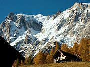
Macugnaga
Macugnaga is a mountain village at 1327 m altitude, in the province of Verbano-Cusio-Ossola, in the north of Piedmont region .It is placed at the base of Dufourspitze 4638 m, the second tallest peak in Europe, in the Monte Rosa Massif, along Anzasca valley, one of the seven valleys around the...
.
Following a long series of attempts beginning in the early nineteenth century Monte Rosa's summit was first reached in 1855 from Zermatt by a party of eight climbers led by three guides.
Each summer a large number of climbers set out from the Monte Rosa Hut
Monte Rosa Hut
The Monte Rosa Hut is a mountain hut located near Zermatt at the foot of Monte Rosa at an altitude of 2,795 metres. It is owned by the Swiss Alpine Club. The hut is the start of the normal route to the summit and other mountains in the area. The first hut was built in 1895...
on the mountain's west side for the summit via the normal route. Many tourists come each year to Zermatt to see the panorama that extends over the giants of the Swiss Alps
Swiss Alps
The Swiss Alps are the portion of the Alps mountain range that lies within Switzerland. Because of their central position within the entire Alpine range, they are also known as the Central Alps....
from Monte Rosa to the Matterhorn
Matterhorn
The Matterhorn , Monte Cervino or Mont Cervin , is a mountain in the Pennine Alps on the border between Switzerland and Italy. Its summit is 4,478 metres high, making it one of the highest peaks in the Alps. The four steep faces, rising above the surrounding glaciers, face the four compass points...
.
Naming
Italian language
Italian is a Romance language spoken mainly in Europe: Italy, Switzerland, San Marino, Vatican City, by minorities in Malta, Monaco, Croatia, Slovenia, France, Libya, Eritrea, and Somalia, and by immigrant communities in the Americas and Australia...
, however rosa is derived from the Franco-Provençal dialect
Franco-Provençal language
Franco-Provençal , Arpitan, or Romand is a Romance language with several distinct dialects that form a linguistic sub-group separate from Langue d'Oïl and Langue d'Oc. The name Franco-Provençal was given to the language by G.I...
word rouese meaning "glacier". On old maps as late as 1740, the mountain was named Monte Bosa and even Monte Biosa by the inhabitants of Val Sesia. The name Mon Boso which appears in Leonardo da Vinci
Leonardo da Vinci
Leonardo di ser Piero da Vinci was an Italian Renaissance polymath: painter, sculptor, architect, musician, scientist, mathematician, engineer, inventor, anatomist, geologist, cartographer, botanist and writer whose genius, perhaps more than that of any other figure, epitomized the Renaissance...
's notebooks very likely designated the same mountain. From Zermatt the mountain was formerly known under the name Gornerhorn (in German, lit. Large mountain). The name gorner is still used for the western ridge that is thrown out from the main mass (Gornergrat) and the glacier that lies at its foot (Gornergletscher) but not used for the mountain itself anymore.
The summit is distinguished by the name Dufourspitze (in German, lit. Dufour Peak; Italian: Punta Dufour, French: Pointe Dufour). This replaced the former name Höchste Spitze (in German, lit. Highest Peak) that was indicated on the Swiss maps before the Federal Council
Swiss Federal Council
The Federal Council is the seven-member executive council which constitutes the federal government of Switzerland and serves as the Swiss collective head of state....
, on January 28, 1863, decided to rename the mountain in honor of Guillaume-Henri Dufour. Dufour was a Swiss engineer, topographer, co-founder of the Red Cross and army officer who led the Sonderbund
Sonderbund
The Sonderbund War of November 1847 was a civil war in Switzerland. It ensued after seven Catholic cantons formed the Sonderbund in 1845 in order to protect their interests against a centralization of power...
campaign. This decision followed the completion of the Dufour Map, a series of military topographical maps created under the command of Dufour.
Elevation and climate
The Swiss national map gives an elevation of 4,633.9 m for the summit (2007) or 4,441 metres above Lake MaggioreLake Maggiore
Lake Maggiore is a large lake located on the south side of the Alps. It is the second largest of Italy and largest of southern Switzerland. Lake Maggiore is the most westerly of the three great prealpine lakes of Italy, it extends for about 70 km between Locarno and Arona.The climate is mild...
, Switzerland's lowest point. A recent work (2000), involving universities and the offices of cartography of Italy and Switzerland, was made in order to record a more precise elevation for Monte Rosa. The result was 4635.25 metres (15,208 ft) from the Italian side and 4634.97 metres (15,207 ft) from the Swiss side, with a margin of error
Margin of error
The margin of error is a statistic expressing the amount of random sampling error in a survey's results. The larger the margin of error, the less faith one should have that the poll's reported results are close to the "true" figures; that is, the figures for the whole population...
of 0.1 m.
Though the Mediterranean can hardly be visible from the summit of Monte Rosa because of intervening mountains, the view to the south extends to the Apennines
Apennine mountains
The Apennines or Apennine Mountains or Greek oros but just as often used alone as a noun. The ancient Greeks and Romans typically but not always used "mountain" in the singular to mean one or a range; thus, "the Apennine mountain" refers to the entire chain and is translated "the Apennine...
, the mountains of Corsica
Corsica
Corsica is an island in the Mediterranean Sea. It is located west of Italy, southeast of the French mainland, and north of the island of Sardinia....
and the Maritime Alps
Maritime Alps
The Maritime Alps are a mountain range in the southwestern part of the Alps. They form the border between the French département Alpes-Maritimes and the Italian province of Cuneo. The Col de Tende separates them from the Ligurian Alps; the Maddalena Pass separates them from the Cottian Alps...
. On the north side the view is limited by the high range of the Bernese Alps
Bernese Alps
The Bernese Alps are a group of mountain ranges in the western part of the Alps, in Switzerland. Although the name suggests that they are located in the Bernese Oberland region of the canton of Bern, portions of the Bernese Alps are in the adjacent cantons of Valais, Lucerne, Obwalden, Fribourg and...
.
Being the highest point in Switzerland, Monte Rosa is also one of the most extreme places. The average air pressure is about half of that of the sea level (56%) and the temperature can reach as low as -40 C. Owing to the frequent prevalence of a high wind from the east or north-east, and the slow pace at which it is possible to move when near the top, precautions against cold are particularly requisite when climbing Monte Rosa. The snow line
Snow line
The climatic snow line is the point above which snow and ice cover the ground throughout the year. The actual snow line may seasonally be significantly lower....
is located at about 3,000 metres.
Geographic setting and description
Zermatt
Zermatt is a municipality in the district of Visp in the German-speaking section of the canton of Valais in Switzerland. It has a population of about 5,800 inhabitants....
, on the south-eastern side of the Swiss canton of Valais
Valais
The Valais is one of the 26 cantons of Switzerland in the southwestern part of the country, around the valley of the Rhône from its headwaters to Lake Geneva, separating the Pennine Alps from the Bernese Alps. The canton is one of the drier parts of Switzerland in its central Rhône valley...
. However the mountain lies a little closer to the village of Macugnaga
Macugnaga
Macugnaga is a mountain village at 1327 m altitude, in the province of Verbano-Cusio-Ossola, in the north of Piedmont region .It is placed at the base of Dufourspitze 4638 m, the second tallest peak in Europe, in the Monte Rosa Massif, along Anzasca valley, one of the seven valleys around the...
, on the Italian
Italy
Italy , officially the Italian Republic languages]] under the European Charter for Regional or Minority Languages. In each of these, Italy's official name is as follows:;;;;;;;;), is a unitary parliamentary republic in South-Central Europe. To the north it borders France, Switzerland, Austria and...
eastern side (8 km) than to the village of Zermatt on the western side (12 km). Other inhabited regions close to the massif are the valleys of Alagna
Alagna
Alagna is a comune in the Province of Pavia in the Italian region Lombardy, located about 40 km southwest of Milan and about 20 km west of Pavia. As of 31 December 2004, it had a population of 876 and an area of 8.6 km²....
and Gressoney
Gressoney
Gressonney may refer to two villages and communes in the Aosta Valley region of Italy:*Gressoney-La-Trinité*Gressoney-Saint-Jeanand to:*Gressoney , the single commune into which they were united during the years 1928–46....
both on the Italian southern side. The west and north side greatly differs from the south and east side. The former is almost completely covered by large glaciers, tributaries of the 57 km² large Gorner Glacier, descending progressively with gentle slopes. Thus the valley is uninhabitated and Zermatt, the first settlement, lies far away from the summit. The latter is a nearly 2.5 km-high wall lying above Macugnaga.
The mountain is mainly covered by eternal snows and glaciers, except for its summit which is a rocky ridge orientated west–east, near to and perpendicular to the main watershed between Switzerland and Italy (Rhône River
Rhône River
The Rhone is one of the major rivers of Europe, rising in Switzerland and running from there through southeastern France. At Arles, near its mouth on the Mediterranean Sea, the river divides into two branches, known as the Great Rhone and the Little Rhone...
and Po River
Po River
The Po |Ligurian]]: Bodincus or Bodencus) is a river that flows either or – considering the length of the Maira, a right bank tributary – eastward across northern Italy, from a spring seeping from a stony hillside at Pian del Re, a flat place at the head of the Val Po under the northwest face...
basins on the Swiss and Italian side respectively). The connecting point between them is the Grenzgipfel
Grenzgipfel
The Grenzgipfel is a subpeak of Monte Rosa, in Italy and Switzerland. In the German language the peak's name means 'frontier summit'....
, the highest summit on the Italian side. Thus Monte Rosa is the highest mountain whose summit is not on the main alpine watershed
Main chain of the Alps
The Alpine divide is the central line of mountains that forms the water divide of the range. Main chains of mountain ranges are traditionally designated in this way, and generally include the highest peaks of a range; the Alps are something of an unusual case in that several significant groups of...
. The Silbersattel and Grenzsattel are the passes located north and south to the summit. In addition several secondary summits are located close: the Nordend
Nordend
Nordend is the northernmost peak of the Monte Rosa Massif. Nordend is the fourth highest peak of the massif, after the Dufourspitze , the Ostspitze and the Grenzgipfel .-External links:*...
(4,609 m), the Zumsteinspitze
Zumsteinspitze
The Zumsteinspitze is a peak in the Pennine Alps on the border between Italy and Switzerland. It is a subpeak of Monte Rosa....
(4,563 m) and the Signalkuppe
Signalkuppe
The Signalkuppe is a peak in the Pennine Alps on the border between Italy and Switzerland. It is a subpeak of Monte Rosa. The mountain is named after 'the Signal', a prominent gendarme atop the east ridge.The first ascent was made by Giovanni Gnifetti, a parish priest from Alagna Valsesia,...
(4,554 m).
Several perpendicular secondary ridges are connected to the main ridge dividing the glaciers that descend towards the Mattertal.The wall connecting the Signalkuppe with the Cima di Jazzi
Cima di Jazzi
Cima di Jazzi is a mountain in the Pennine Alps on the Swiss-Italian border.-External links:*...
presents a wall of formidable precipices towards the east, but falls away in a gentle slope to the west. For a breadth of a few kilometres the upper snow-fields lie almost unbroken upon this slope, but as they begin to descend towards the main valley they are divided into two icestreams by a ridge which gradually emerges from the névé, and finally presents a rather bold front to the glaciers on either side. The highest points of this ridge, appearing insignificant by contrast with the grand objects around, is the Stockhorn
Stockhorn (Zermatt)
The Stockhorn is a mountain in the Pennine Alps. It is located to the Southeast of the town of Zermatt, and features several ungroomed ski runs....
and the Gornergrat
Gornergrat
The Gornergrat is a ridge of the Pennine Alps, Switzerland, overlooking the Gorner Glacier to the south. It can be reached by the Gornergratbahn rack railway from Zermatt...
. On its south side is the Gorner Glacier, formed by the confluence of all the minor glaciers descending from the north and west sides of the Monte Rosa range, while on the north side the Findel Glacier
Findel Glacier
The Findel Glacier is a valley glacier in the Monte Rosa massif east of Zermatt in the Pennine Alps. It has a length of and covers an area of ....
descends near to the hamlet of Findeln.
Monte Rosa is one of the high mountains surrounding the 40 km long Matter
Mattertal
The Matter Valley is located in southwestern Switzerland, south of the Rhone valley in the canton of Valais. The village of Zermatt is the most important settlement of the valley, which is surrounded by many four-thousanders, including the Matterhorn.-Geography:Located in the Pennine Alps, the...
valley south of Visp
Visp
Visp is the capital of the district of Visp in the canton of Valais in Switzerland.-Geography:Visp has an area, , of . Of this area, 17.0% is used for agricultural purposes, while 59.7% is forested...
. On the west are Lyskamm
Lyskamm
Lyskamm is a mountain in the Pennine Alps lying on the border between Switzerland and Italy. It consists of a five-kilometre-long ridge with two distinct peaks...
, Zwillinge, the Breithorn
Breithorn
The Breithorn is a mountain in the Pennine Alps, located close to the Matterhorn. It is considered the most easily climbed 4,000 m Alpine peak. This is due to the Klein Matterhorn cable car which takes climbers to over 3,820 m for a starting point. The standard route continues over a glacial...
and the Matterhorn
Matterhorn
The Matterhorn , Monte Cervino or Mont Cervin , is a mountain in the Pennine Alps on the border between Switzerland and Italy. Its summit is 4,478 metres high, making it one of the highest peaks in the Alps. The four steep faces, rising above the surrounding glaciers, face the four compass points...
; on the north are the Weisshorn
Weisshorn
The Weisshorn is a mountain in the Pennine Alps, in Switzerland. With its summit, it is one of the major peaks in the Alps and overtops the nearby Matterhorn by some 30 metres. It was first climbed in 1861 from Randa by John Tyndall, accompanied by the guides J.J...
and the Dom. The Gornergrat
Gornergrat
The Gornergrat is a ridge of the Pennine Alps, Switzerland, overlooking the Gorner Glacier to the south. It can be reached by the Gornergratbahn rack railway from Zermatt...
summit, lying 8 km on the north-west at 3,100 metres, is a popular view point of the massif since it is accessible by train from Zermatt, using the highest open air railway line in Europe.
Because of the low elevation of the mountains to the south, the 2165 m (7,103 ft) prominence of Monte Rosa is well visible from the plains of Lombardy
Lombardy
Lombardy is one of the 20 regions of Italy. The capital is Milan. One-sixth of Italy's population lives in Lombardy and about one fifth of Italy's GDP is produced in this region, making it the most populous and richest region in the country and one of the richest in the whole of Europe...
.
Geology
The entire massif consists mainly of graniteGranite
Granite is a common and widely occurring type of intrusive, felsic, igneous rock. Granite usually has a medium- to coarse-grained texture. Occasionally some individual crystals are larger than the groundmass, in which case the texture is known as porphyritic. A granitic rock with a porphyritic...
and granite gneiss
Gneiss
Gneiss is a common and widely distributed type of rock formed by high-grade regional metamorphic processes from pre-existing formations that were originally either igneous or sedimentary rocks.-Etymology:...
(a metamorphic rock
Metamorphic rock
Metamorphic rock is the transformation of an existing rock type, the protolith, in a process called metamorphism, which means "change in form". The protolith is subjected to heat and pressure causing profound physical and/or chemical change...
with foliations). The Monte Rosa Nappe lies below the Zermatt-Saas zone
Zermatt-Saas zone
The Zermatt-Saas zone is a tectonic unit in the western part of the Alps. Its lithology is mainly ophiolite but there are some pelitic zones too....
and is part of the Penninic nappes
Penninic nappes
The Penninic nappes or the Penninicum are one of three nappe stacks and geological zones in which the Alps can be divided. In the western Alps the Penninic nappes are more obviously present than in the eastern Alps , where they crop out as a narrow band...
in the Briançonnais microcontinent
Briançonnais microcontinent
The Briançonnais zone or Briançonnais terrane is a piece of continental crust found in the Penninic nappes of the Alps.According to some paleogeographic reconstructions the rocks of the Briançonnais zone were in fact a part of the microcontinent Iberia, that encompassed not only the Iberian...
zone, although its paleographic origin is controversial and is sometimes assigned to the Sub-Penninic nappes. Rocks in the paragneiss of the Monte Rosa Nappe record eclogite
Eclogite
Eclogite is a mafic metamorphic rock. Eclogite is of special interest for at least two reasons. First, it forms at pressures greater than those typical of the crust of the Earth...
-facies metamorphism. The deformation of the Monte Rosa granites indicates a depth of subduction
Subduction
In geology, subduction is the process that takes place at convergent boundaries by which one tectonic plate moves under another tectonic plate, sinking into the Earth's mantle, as the plates converge. These 3D regions of mantle downwellings are known as "Subduction Zones"...
of about 60 km. They were brought to the surface by tectonic uplift
Tectonic uplift
Tectonic uplift is a geological process most often caused by plate tectonics which increases elevation. The opposite of uplift is subsidence, which results in a decrease in elevation. Uplift may be orogenic or isostatic.-Orogenic uplift:...
, which still continues today.
The summit is a sharp, jagged edge of mica schist connected by an arête with the Nordend, but cut off from the Zumsteinspitze to the south by nearly vertical rocks about 400 ft. in height.
Trekking
The Tour of Monte RosaMonte Rosa tour
The Monte Rosa Tour is a circular hiking trail through the Swiss & Italian Alps around Monte Rosa . The tour also encircles the Dom in the Mischabel range.Typical overnight stops are* Zermatt* Theodulpass...
can be effected by trekkers in about 10 days. The circuit follows many ancient trails that have linked the Swiss and Italian valleys for centuries. The circuit includes larch forests, alpine meadows, balcony trails and a glacial crossing. It connects seven valleys embracing different cultures: the German speaking high Valais, the originally French speaking and Italian Val d'Aosta and the valleys of Lombardy
Lombardy
Lombardy is one of the 20 regions of Italy. The capital is Milan. One-sixth of Italy's population lives in Lombardy and about one fifth of Italy's GDP is produced in this region, making it the most populous and richest region in the country and one of the richest in the whole of Europe...
and Piedmont
Piedmont
Piedmont is one of the 20 regions of Italy. It has an area of 25,402 square kilometres and a population of about 4.4 million. The capital of Piedmont is Turin. The main local language is Piedmontese. Occitan is also spoken by a minority in the Occitan Valleys situated in the Provinces of...
. Good conditions are necessary to circumnavigate the massif. After reaching St. Jacques by the Theodul Pass
Theodul Pass
The Theodul Pass is a high mountain pass across the eastern Pennine Alps, connecting Zermatt in the Swiss canton of Valais and Breuil-Cervinia in the Italian region of Aosta Valley.The pass lies between the Matterhorn on the west and the Breithorn on...
and the Col des Cimes Blanches, the trekker crosses the Bettaforca before arriving at Gressoney
Gressoney-La-Trinité
Gressoney-La-Trinité is a town and comune in the Aosta Valley region of north-western Italy.-Geography:...
. Then two passes must be crossed on the road to Macugnaga, the Col d'Olen and the Colle del Turlo. From Macugnaga the trekker reaches the Saastal
Saastal
The Saastal or the Saas Valley is an alpine valley in the Canton of Valais, Switzerland. It is separated from the Mattertal valley by the Dom....
by the Monte Moro
Monte Moro
Monte Moro is a mountain in the Pennine Alps on the Swiss-Italian border.-External links:*...
and goes around the Mischabelhörner
Mischabelhörner
The Mischabelhörner, or just Mischabel, is a massif in the Pennine Alps of Valais, Switzerland, which forms the divide between the Saastal and Mattertal. Of all its summits, the highest is the Dom; at 4545 m the highest peak completely inside Switzerland. The other two chief summits are the...
before ending his journey in Zermatt. In total six passes between 2700 and 3300 metres must be crossed on a relatively difficult terrain.
Early exploration
Monte Rosa could be seen from many places on the south side of the Alps and it had been mentioned in many travel diaries. At the end of the 15th century some outlines of the mountain may possibly have been painted by Leonardo da VinciLeonardo da Vinci
Leonardo di ser Piero da Vinci was an Italian Renaissance polymath: painter, sculptor, architect, musician, scientist, mathematician, engineer, inventor, anatomist, geologist, cartographer, botanist and writer whose genius, perhaps more than that of any other figure, epitomized the Renaissance...
into the background of the Madonna of the Rocks or other pictures. Da Vinci explored the Italian side of the mountain and made some observations, though there is but scanty evidence that he had climbed even a minor summit in the neighbourhood. He was intringued by the permanent snow lying on the mountain and the darkness of the sky above him, he wrote:
- "The base of this mountain gives birth to the 4 rivers which flow in four different directions through the whole of Europe. And no mountain has its base at so great a height as this, which lifts itself above almost all the clouds; and snow seldom falls there, but only hail in the summer, when the clouds are highest. And this hail lies [unmelted] there, so that if it were not for the absorption of the rising and falling clouds, which does not happen more than twice in an age, an enormous mass of ice would be piled up there by the layers of hail, and in the middle of July I found it very considerable; and I saw the sky above me quite dark, and the sun as it fell on the mountain was far brighter here than in the plains below, because a smaller extent of atmosphere lay between the summit of the mountain and the sun."
At the end of the eighteenth century, the people of the Italian valleys believed that a lost valley existed, hidden away between the glaciers of the great chain. The discovery of the valley was due to Jean Joseph Beck of Gressoney. He collected a large party and they set out on a Sunday of August 1788. They started from their sleeping places at midnight, and roped carefully. They had furnished themselves with climbing irons and alpenstocks. At the head of the glacier, they encountered a slope of rock devoid of snow, which they climbed.
- "It was twelve o'clock. Hardly had we got to the summit of the rock than we saw a grand-an amazing-spectacle. We sat down to contemplate at our leisure the lost valley, which seemed to us to be entirely covered with glaciers. We examined it carefully, but could not satisfy ourselves that it was the unknown valley, seeing that none of us had ever been in the Vallais."
The valley, in fact, was none other than the upper valley of Zermatt
Mattertal
The Matter Valley is located in southwestern Switzerland, south of the Rhone valley in the canton of Valais. The village of Zermatt is the most important settlement of the valley, which is surrounded by many four-thousanders, including the Matterhorn.-Geography:Located in the Pennine Alps, the...
, and the pass, which these early explorers had reached, was the Lysjoch
Lysjoch
The Lysjoch is a very high pass in the Pennine Alps between Italy and Switzerland. It is located east of the Lyskamm and west of the Ludwigshöhe near Monte Rosa. The pass is at 4,151 meters and is east of the Entdeckungsfels....
, where, to this day, the rock on which they rested bears the name that they gave it, the "Entdeckungsfels
Entdeckungsfels
The Entdeckungsfels is a minor summit located west of the Lysjoch very close to the Italian border, between Liskamm and Ludwigshöhe. Because of its small prominence it was included in the enlarged list of alpine four-thousanders....
" (German: Rock of Discovery). Beck's party thus reached a height of 4,178 metres (13,707 ft), a record at that times.
Count Morozzo of Turin was inspired by the view of Monte Rosa and in 1787 he tried to reach its summit from the east face. However he did not go very high, and the mountain looked much too inaccessible to encourage him to proceed further. He reached the place of the actual Marinelli hut, 1,500 m below the summit. The route on the east face was opened only in 1873. In 1789, following the recommandation of the Count, Horace-Bénédict de Saussure
Horace-Bénédict de Saussure
200px|thumb|Portrait of Horace-Bénédict de Saussure Horace-Bénédict de Saussure was a Genevan aristocrat, physicist and Alpine traveller, often considered the founder of alpinism, and considered to be the first person to build a successful solar oven.-Life and work:Saussure was born in Conches,...
went to Macugnaga to explore the mountain. He climbed the Pizzo Bianco, a summit facing the mountain and measured the altitude of Monte Rosa. He found a height of 2430 toise
Toise
A toise is a unit of measure for length, area and volume originating in pre-revolutionary France. In North America, it was used in colonial French establishments in early New France, French Louisiana , and Quebec...
s.
A first serious attempt was made in 1801 by a doctor of Alagna, Pietro Giordani. If he did not reach the summit, he reached alone a great height when successfully climbing a 4,046 metres high virgin summit, later named Punta Giordani in his honour. When climbing the peak, he had arrived too late on the summit to have time to proceed further and night drove him away. He had to sleep in a cleft of ice at about 14'000 feet. He wrote an account of his exploit: After an eloquent description of the view, he expresses his annoyance at the lack of scientific instruments, and the lateness of the hour which prevented him from ascending Monte Rosa itself.
Another attempt was made by Joseph Zumstein and party of two friends in 1820. They reached a 4,563 metres high secondary summit, later named Zumsteinspitze
Zumsteinspitze
The Zumsteinspitze is a peak in the Pennine Alps on the border between Italy and Switzerland. It is a subpeak of Monte Rosa....
. The climb was dangerous, as the party had to traverse under threatening walls of ice; they also had great difficulties on descent, because the afternoon sun had melted the snow on the slopes. They used mules to carry their equipment as far as the snow-line. During the expedition they thought they had climbed the true highest peak, but when they reached the summit they found out it was only a subpeak of Monte Rosa. Zumstein was anxious to return later and reach the highest summit, but his desire did not materialize.
First ascents
Zermatt
Zermatt is a municipality in the district of Visp in the German-speaking section of the canton of Valais in Switzerland. It has a population of about 5,800 inhabitants....
on August 1, 1855 by John Birkbeck, Charles Hudson, Christopher Smyth, James Greenville Smyth, Edward Stephenson with the guides Matthäus Zumtaugwald and Johannes Zumtaugwald (from Zermatt) and Ulrich Lauener (from Lauterbrunnen). They followed the already opened route to the Ostspitze via the Silbersattel. On the summits, instead of turning back on the same way, they decided to continue on the unexplored western ridge and thus passed the true summit before going down to Zermatt. One of the climbers, Charles Hudson, would die 10 years later during the first ascent of the Matterhorn
First ascent of the Matterhorn
The first ascent of the Matterhorn was made by Edward Whymper, Lord Francis Douglas, Charles Hudson, Douglas Hadow, Michel Croz, and the two Zermatt guides, Peter Taugwalder father and son on 14 July 1865. Douglas, Hudson, Hadow and Croz were killed on the descent when Hadow slipped and pulled the...
.
John Tyndall
John Tyndall
John Tyndall FRS was a prominent Irish 19th century physicist. His initial scientific fame arose in the 1850s from his study of diamagnetism. Later he studied thermal radiation, and produced a number of discoveries about processes in the atmosphere...
, the prominent physicist, was also an accomplished mountaineer, and made the first solo ascent in 1858, which he described in his account, Glaciers of the Alps. Tyndall had already summited Monte Rosa in a guided group one week before but he made an unplanned second summit solo on 17 August.
- "After breakfast I poured what remained of my tea into a small glass bottle, an ordinary demi-bouteille in fact; the waiter then provided me with a ham sandwich, and, with my scrip thus frugally furnished, I thought the heights of Monte Rosa might be won..."
After encountering a party of climbers guided by Lauener, Tyndall reached alone the summit:
- "A world of clouds and mountains lay beneath me. Switzerland, with its pomp of summits, was clear and grand; Italy was also grand, but more than half obscured. Dark cumulus and dark crag vied in savagery, while at other places white snows and white clouds held equal rivalry. The scooped valleys of Monte Rosa itself were magnificent, all gleaming in the bright sunlight — tossed and torn at intervals, and sending from their rents and walls the magical blue of the ice."
Among mountain guides, the eastern wall had the reputation of being unconquerable. Ferdinand Imseng was convinced that the central couloir, which would be named Marinelli couloir later, was feasible. He succeeded in convincing other climbers and, on 22 July 1872, Richard Pendlebury, William and Charles Taylor, Ferdinand Imseng, Gabriel Spechtenhauser and Giovanni Oberto began the ascent from Macugnaga. They were aware of the objective dangers of the wall but they decided to go as high as possible, without compromising their lives. After a bivouac on the actual Marinelli hut emplacement, they headed towards the Grenzsattel. Suddenly, when they arrived near the Grenzsattel, an avalanche started and rivers of snow began to flow everywhere around the climbers. They were able to reach the safe rocks of the Grenzgipfel
Grenzgipfel
The Grenzgipfel is a subpeak of Monte Rosa, in Italy and Switzerland. In the German language the peak's name means 'frontier summit'....
just in time to save their lives. They finally reached the summit and descended to Riffelalp on the other side, concluding an 18-hour journey.
This ascent made Ferdinand Imseng a famous mountain guide. He lost his life in 1881 on the east wall during the third ascent with Damiano Marinelli and guide P. Pedranzini. On 8 August, they were caught by an avalanche and brought 1,200 metres down. The accident was reported by a porter who survived. The couloir was then named Marinelli."
Other ascents
In 1889 Achille Ratti, who became later Pope Pius XI, made the first traverse from Macugnaga to Zermatt by the Zumsteinjoch. After climbing the Dufourspitze, he spent the night on the summit with his companions.Visiting Zermatt in 1894, the young Winston Churchill
Winston Churchill
Sir Winston Leonard Spencer-Churchill, was a predominantly Conservative British politician and statesman known for his leadership of the United Kingdom during the Second World War. He is widely regarded as one of the greatest wartime leaders of the century and served as Prime Minister twice...
insisted on an ascent of Monte Rosa rather than of the Matterhorn, not only because of its superior height but also because the guides' fee was substantially less.
More recently, on August 1 (which happens to be the Swiss National Day
Swiss National Day
The Swiss National Day is the national holiday of Switzerland, set on 1 August. It is an official national holiday since 1994, although the day had been suggested for the celebration of the foundation of the Swiss Confederacy as early as 1889.-History:...
), 2005, the Swiss Minister of Treasure
Federal Department of Economic Affairs
The Federal Department of Economic Affairs is one of the seven departments of the federal government of Switzerland, headed by a member of the Swiss Federal Council.-Organisation:The Department is composed of the following offices:...
Joseph Deiss
Joseph Deiss
Joseph Deiss is an economist, Swiss politician and a member of the Christian Democratic People's Party . From 1999 to 2006, he was a member of the Swiss Federal Council, heading first the Federal Department of Foreign Affairs and then the Federal Department of Economic Affairs...
climbed the Dufourspitze. The expedition marked the 150th anniversary of the first ascent.
Huts and climbing routes
The Monte Rosa HutMonte Rosa Hut
The Monte Rosa Hut is a mountain hut located near Zermatt at the foot of Monte Rosa at an altitude of 2,795 metres. It is owned by the Swiss Alpine Club. The hut is the start of the normal route to the summit and other mountains in the area. The first hut was built in 1895...
(2,883 m) is the only mountain hut in the massif owned by the Swiss Alpine Club
Swiss Alpine Club
The Swiss Alpine Club is the largest mountaineering club in Switzerland. It was founded in 1863 in Olten and it is now composed of 111 sections with 110,000 members...
. It is situated on the Plattje, a rocky island between the Gorner and Grenz glaciers. It is accessible from Rotenboden, a station on the Gornergratbahn
Gornergratbahn
The Gornergratbahn is a nine-kilometre metre-gauge mountain rack railway, with Abt rack system. It leads from Zermatt, Switzerland , up to the Gornergrat...
line. The hut was inaugurated in 1894 and rebuilt in 1940. In 2009, a new high technology mountain hut was inaugurated. The five-story crystal-shaped building is designed to obtain 90 per cent of its power needs from the sun and will be used as a research station.
The other huts are owned by the Italian Alpine Club
Club Alpino Italiano
The Club Alpino Italiano is the senior Italian alpine club which stages climbing competitions, operates alpine huts, marks and maintains paths, and is active in protecting the Alpine environment...
, among them the Regina Margherita Hut located at 4,559 metres on the Signalkuppe
Signalkuppe
The Signalkuppe is a peak in the Pennine Alps on the border between Italy and Switzerland. It is a subpeak of Monte Rosa. The mountain is named after 'the Signal', a prominent gendarme atop the east ridge.The first ascent was made by Giovanni Gnifetti, a parish priest from Alagna Valsesia,...
. Inaugurated in 1893 and replaced in 1979, it is still the highest construction in Europe, which include a laboratory and observatory.
Other huts owned by the Italian Alpine Club are the Marinelli Hut (3,036 m), used for the ascent of the east face, and the Bivacco Città di Gallarate (3,960 m), located near the summit of the Jägerhorn
Jägerhorn
Jägerhorn is a mountain in the Pennine Alps on the Swiss-Italian border.-External links:*...
.
Normal route
The normal route to the summit start from the Monte Rosa HutMonte Rosa Hut
The Monte Rosa Hut is a mountain hut located near Zermatt at the foot of Monte Rosa at an altitude of 2,795 metres. It is owned by the Swiss Alpine Club. The hut is the start of the normal route to the summit and other mountains in the area. The first hut was built in 1895...
. The normal route is mainly a glacier itinerary on the west slopes of Monte Rosa (Monte Rosa Glacier), with the final rocky west ridge to the summit. Although the itinerary itself is not difficult, it requires physical endurance and a good acclimatization
Acclimatization
Acclimatisation or acclimation is the process of an individual organism adjusting to a gradual change in its environment, allowing it to maintain performance across a range of environmental conditions...
.
Marinelli couloir
The route starts from the Marinelli Hut and follows the steep Marinelli couloir on the east face. It is a long and dangerous route and has to be ascended very early in the morning on cold days in order to decrease the risk of avalanches.Timeline
- First ascent in 1855 (normal route).
- First ascent on the eastern wall, via the Marinelli Couloir in 1872 (July 22) by Taylor, Pendlebury and Ferdinand Imseng (guide)
- First ascent via the southern spur (Cresta Rey) by Eustace Hulton with guides Joseph Moser and Peter Rubi on 20 August 1874.
- First ascent via the southeast ridge (today route from Margherita hut) by F. P. Barlow, G. W. Prothero with guides Antonio Carrel and Peter Taugwalder on 31 August 1874.
- First winter ascent via the southern spur (Cresta Rey) by Vittorio SellaVittorio SellaVittorio Sella was an Italian photographer and mountaineer, who took photographs of mountains which are regarded as some of the finest ever made....
with guides Daniel Maquignaz and Joseph Maquignaz on 26 January 1884. - First winter ascent via the southeast ridge by Mario Piacenza, A. Curta, A. Lazier, O. Lazier on 18 January 1907.
- First solo ascent of the east face by Angelo Taveggia in 1924.
- First winter ascent of the east face in 1965 (February 5–6) by mountain guides Luciano Bettineschi, Felice Jacchini, Michele Pala and Lino Pironi.
- In June 1969, the extreme skierExtreme skiingExtreme skiing is skiing performed on long, steep slopes in dangerous terrain. The sport is performed off-piste.The French coined the term 'Le Ski Extreme' in the 1970s...
Sylvain SaudanSylvain SaudanSylvain Saudan is an extreme skier, dubbed "skier of the impossible." He is noted for skiing down large and steep mountains, including those in the Himalayas. In 2007 he survived a helicopter crash in Kashmir....
descended the entire Marinelli Couloir on the east face. - First solo winter ascent via the east face on February 4, 1991, by Walter Bernardi. Injured, he was rescued by helicopter on the descent near the Grenzsattel.
- First ascent by a woman - Lucy Walker July 15, 1862 with Frank Walker and guide Melchior Anderegg
Panorama
External links
- Dufourspitze on SummitPost.org
- Computer generated summit panoramas North South Index
- Virtual climb of the Dufourspitze with 360 degree panoramas
- Monte Rosa with Dufourspitze
- Peakbagger link