
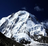
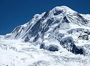
Lyskamm
Encyclopedia
Lyskamm (4527 m) is a mountain
in the Pennine Alps
lying on the border between Switzerland
and Italy
. It consists of a five-kilometre-long ridge with two distinct peaks. The mountain has gained a reputation for seriousness because of the many cornices lying on the ridge and the frequent avalanches, thus leading to its nickname the Menschenfresser (man eater).
 Because of its modest prominence (376 m), Lyskamm is sometimes considered to be part of the nearby Monte Rosa Massif (in fact the Dufourspitze
is only 107 metres higher). But visually Lyskamm is a huge massif, composed of two summits: the Eastern Liskamm and the lower Western Liskamm, separated by a one-km-long ridge, both lying on the border between the Swiss canton of Valais
(north) and the Italian region of the Aosta Valley (south).
The northern side of the mountain is an impressive 1100-metre ice-covered wall, rising up from the Gorner Glacier. The gentler southern side rises only a few hundred metres above the glacier
below (Ghiacciaio del Lis).
. The other Englishmen were A. C. Ramsey, F. Sibson, T. Rennison, J. A. Hudson, C. H. Pilkington and R. M. Stephenson. The guides were J.-P. Cachet, F. Lochmatter, K. Kerr, S. Zumtaugwald, P. and J.-M. Perren.
 The ridge as a whole (as well as the western summit) was first traversed three years later by Leslie Stephen
, Edward Buxton, Jakob Anderegg and Franz Biener.
The first attempt to climb the imposing north-east face was made in 1880 by the brothers Kalbermatten. They were carried down to the glacier by an avalanche but they survived the accident. On 9 August 1890, L. Norman-Neruda with guides Christian Klucker
and J. Reinstadler were the first to reach the summit (Lyskamm East) by the north face, by what is now known as the "Norman-Neruda route". The first winter ascent of this route was made on 11 March 1956 by C. Fosson and O. Frachey.
In 1907, Geoffrey Winthrop Young
and his guide traversed the whole ridge two times. Young wanted to traverse the ridge from the Nordend
to the Breithorn
. They started from Riffelalp at midnight and finished the traverse of the Monte Rosa massif at midday. But after the traverse of the Lyskamm and Castor the guide was too tired. Young, who was very disappointed, convinced him to go back by the Lysjoch before descending to Zermatt, implying a second traverse on the Lyskamm. Young even wanted to continue back to the Nordend but his guide refused to prolong the journey.
(2,795 m). The route follows the route taken by the first ascentionists.
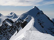
The mountain is often climbed as a traverse from the Feliksjoch (West), to the Lysjoch (East) or vice versa. The traverse consists mostly of a narrow, snow-covered ridge, with some scrambling over rocks. In good conditions, this route is fairly easy and objectively safe, however in bad snow conditions and/or bad visibility, the ridge can be challenging because of large, sometimes double, cornices
, mainly on the southern side of the ridge.
Mountain
Image:Himalaya_annotated.jpg|thumb|right|The Himalayan mountain range with Mount Everestrect 58 14 160 49 Chomo Lonzorect 200 28 335 52 Makalurect 378 24 566 45 Mount Everestrect 188 581 920 656 Tibetan Plateaurect 250 406 340 427 Rong River...
in the Pennine Alps
Pennine Alps
The Pennine Alps are a mountain range in the western part of the Alps. They are located in Switzerland and Italy...
lying on the border between Switzerland
Switzerland
Switzerland name of one of the Swiss cantons. ; ; ; or ), in its full name the Swiss Confederation , is a federal republic consisting of 26 cantons, with Bern as the seat of the federal authorities. The country is situated in Western Europe,Or Central Europe depending on the definition....
and Italy
Italy
Italy , officially the Italian Republic languages]] under the European Charter for Regional or Minority Languages. In each of these, Italy's official name is as follows:;;;;;;;;), is a unitary parliamentary republic in South-Central Europe. To the north it borders France, Switzerland, Austria and...
. It consists of a five-kilometre-long ridge with two distinct peaks. The mountain has gained a reputation for seriousness because of the many cornices lying on the ridge and the frequent avalanches, thus leading to its nickname the Menschenfresser (man eater).
Geography
Dufourspitze
Monte Rosa is the highest mountain of Switzerland, the second highest both of the Alps and western Europe. Distinguished by the name Dufourspitze, its summit is the culminating point of the Pennine Alps...
is only 107 metres higher). But visually Lyskamm is a huge massif, composed of two summits: the Eastern Liskamm and the lower Western Liskamm, separated by a one-km-long ridge, both lying on the border between the Swiss canton of Valais
Valais
The Valais is one of the 26 cantons of Switzerland in the southwestern part of the country, around the valley of the Rhône from its headwaters to Lake Geneva, separating the Pennine Alps from the Bernese Alps. The canton is one of the drier parts of Switzerland in its central Rhône valley...
(north) and the Italian region of the Aosta Valley (south).
The northern side of the mountain is an impressive 1100-metre ice-covered wall, rising up from the Gorner Glacier. The gentler southern side rises only a few hundred metres above the glacier
Glacier
A glacier is a large persistent body of ice that forms where the accumulation of snow exceeds its ablation over many years, often centuries. At least 0.1 km² in area and 50 m thick, but often much larger, a glacier slowly deforms and flows due to stresses induced by its weight...
below (Ghiacciaio del Lis).
Climbing history
The eastern and higher of the two peaks is 4,527 m, and was first ascended in 1861 from the Lysjoch up the east ridge by a 14-man team (eight Englishmen and six Swiss guides) led by J. F. Hardy and including William Edward HallWilliam Edward Hall
William Edward Hall was an English lawyer and mountaineer who published some influential works on international law.-Early life:...
. The other Englishmen were A. C. Ramsey, F. Sibson, T. Rennison, J. A. Hudson, C. H. Pilkington and R. M. Stephenson. The guides were J.-P. Cachet, F. Lochmatter, K. Kerr, S. Zumtaugwald, P. and J.-M. Perren.
Leslie Stephen
Sir Leslie Stephen, KCB was an English author, critic and mountaineer, and the father of Virginia Woolf and Vanessa Bell.-Life:...
, Edward Buxton, Jakob Anderegg and Franz Biener.
The first attempt to climb the imposing north-east face was made in 1880 by the brothers Kalbermatten. They were carried down to the glacier by an avalanche but they survived the accident. On 9 August 1890, L. Norman-Neruda with guides Christian Klucker
Christian Klucker
Christian Klucker was a Swiss mountain guide who made many first ascents in the Alps, particularly in the Bernina Range, the Bregaglia and the Pennine Alps.Amongst his first ascents were:...
and J. Reinstadler were the first to reach the summit (Lyskamm East) by the north face, by what is now known as the "Norman-Neruda route". The first winter ascent of this route was made on 11 March 1956 by C. Fosson and O. Frachey.
In 1907, Geoffrey Winthrop Young
Geoffrey Winthrop Young
Geoffrey Winthrop Young D.Litt. was a British climber, poet and educator, and author of several notable books on mountaineering.-Mountaineering:...
and his guide traversed the whole ridge two times. Young wanted to traverse the ridge from the Nordend
Nordend
Nordend is the northernmost peak of the Monte Rosa Massif. Nordend is the fourth highest peak of the massif, after the Dufourspitze , the Ostspitze and the Grenzgipfel .-External links:*...
to the Breithorn
Breithorn
The Breithorn is a mountain in the Pennine Alps, located close to the Matterhorn. It is considered the most easily climbed 4,000 m Alpine peak. This is due to the Klein Matterhorn cable car which takes climbers to over 3,820 m for a starting point. The standard route continues over a glacial...
. They started from Riffelalp at midnight and finished the traverse of the Monte Rosa massif at midday. But after the traverse of the Lyskamm and Castor the guide was too tired. Young, who was very disappointed, convinced him to go back by the Lysjoch before descending to Zermatt, implying a second traverse on the Lyskamm. Young even wanted to continue back to the Nordend but his guide refused to prolong the journey.
Climbing routes
The normal route starts from the Lysjoch, which can be accessed from the Gnifetti Hut (3,650 m) or from the Monte Rosa HutMonte Rosa Hut
The Monte Rosa Hut is a mountain hut located near Zermatt at the foot of Monte Rosa at an altitude of 2,795 metres. It is owned by the Swiss Alpine Club. The hut is the start of the normal route to the summit and other mountains in the area. The first hut was built in 1895...
(2,795 m). The route follows the route taken by the first ascentionists.
The mountain is often climbed as a traverse from the Feliksjoch (West), to the Lysjoch (East) or vice versa. The traverse consists mostly of a narrow, snow-covered ridge, with some scrambling over rocks. In good conditions, this route is fairly easy and objectively safe, however in bad snow conditions and/or bad visibility, the ridge can be challenging because of large, sometimes double, cornices
Cornice (climbing)
A snow cornice or simply cornice is an overhanging edge of snow on a ridge or the crest of a mountain. They form by wind blowing snow over the crest of the mountain, so they often form on the leeward sides of mountains...
, mainly on the southern side of the ridge.
External links
- Lyskamm on SummitPost
- Italian route account from south - Czech and English