
Bernese Alps
Encyclopedia
The Bernese Alps are a group of mountain range
s in the western part of the Alps
, in Switzerland
. Although the name suggests that they are located in the Bernese Oberland
region of the canton of Bern, portions of the Bernese Alps are in the adjacent cantons of Valais
, Lucerne
, Obwalden
, Fribourg
and Vaud
. The latter being informally named Fribourg Alps and Vaud Alps respectively.
The Rhône
valley separates them from the Chablais Alps
in the west and from the Pennine Alps
in the south; the upper Rhône valley separate them from the Lepontine Alps
in the south-east; the Grimsel Pass
and the Aar valley separates them from the Urner Alps
in the east; their northern edge is not so well defined, describing a line roughly from Lake Geneva
to Lake Lucerne
.
The Bernese Alps are drained by the river Aar and its tributary Saane
in the north, the Rhône
in the south and the Reuss
in the east.
finds its way to Lake Geneva, to the Grimsel Pass
or, depending on the definition, to the river Reuss (thus including the Urner Alps
). The principal ridge, a 100 km long chain running from west (Dent de Morcles
) to east (Sidelhorn
), whose highest peak is the Finsteraarhorn
, forms the watershed between the cantons of Berne
and Valais
. Except for the westernmost part, it is also the watershed between the Rhine (North Sea
) and the Rhone (Mediterranean Sea
). This chain is not centered inside the range but lies close (10 to 15 km) to the Rhone river on the south. This makes a large difference between the south, where the lateral short valleys descend abruptly into the deep trench forming the valley of the Rhone and the north, where the Bernese Alps extends through a great part of the canton of Berne (Bernese Oberland
), throwing out branches to the west into the adjoining cantons of Vaud
and Fribourg
. There the mountains progressively become lower and disappear into the hilly Swiss Plateau
or into the Lake Thun
and Brienz
on the eastern part.
The main chain west of Gemmi Pass
consists mainly of a few large prominent summits (as the Wildhorn
) slightly above 3000 metres, generally covered by glacier
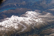
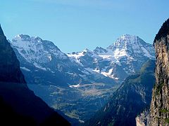
s. On the eastern part, the main chain became suddenly wider and the peaks reach over 4000 metres, in the most glaciated part of the Alps
.
A characteristic in the orography of the Bernese Alps is, that whereas the western of that chain consists of a single series of summits with comparatively short projecting buttresses, the higher group presents a series of longitudinal ridges parallel to the axis of the main chain, and separated from each other by deep valleys that form the channels of great glaciers. Thus the Tschingel Glacier
and the Kander Glacier
, separate the portion of the main range lying between the Gemmi Pass
and the Mittaghorn from the equally high parallel range of the Doldenhorn
and Blümlisalp on its northern side. To the south the same portion of the main range is divided from the still higher parallel range whose summits are the Aletschhorn
and the Bietschhorn
by the Lötschental
and the Lötschenlücke
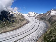
. To this again succeeds the deep trench through which the lower part of the Aletsch Glacier
flows down to the Rhone, enclosed by the minor ridge that culminates at the Eggishorn
.
It is in the central and eastern portions of the range only that crystalline rocks make their appearance; the western part is composed almost exclusively of sedimentary deposits, and the secondary ridges extending through Berne and the adjoining cantons are formed of jurassic
, cretaceous
, or eocene
strata
.
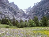
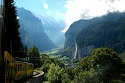 The beauty of the scenery, and the facilities offered to travellers by the general extension of mountain railways, make the northern side of the range, the Bernese Oberland
, one of the portions of the Alps most visited by tourists. Since strangers first began to visit the Alps, the names of Grindelwald
, Lauterbrunnen
, and Interlaken
have been famous. But unlike many other Alpine
regions, which have been left to be explored by strangers, this region has been long visited by Swiss travellers and men of sciences. Among them were the brother Meyer of Aarau and Franz Joseph Hugi. They have explored most of the mountain ranges not very difficult of access, and, further than this, have attained most of the higher summits. In 1841, Louis Agassiz
, with several scientific friends, established a temporary station on the Unteraar Glacier
, and, along with scientific observations on the glaciers, started a series of expeditions. The works of Desor
and Gottlieb Studer
have been followed by several other publications that bear testimony to Swiss mountaineering activity. Notwithstanding the activity of their predecessors, the members of the English Alpine Club
have found scope for further exploits, amongst which may be reckoned the first ascents of the Aletschhorn
and the Schreckhorn
, and the still more arduous enterprise of crossing the range by passes, such as the Jungfraujoch
and Eigerjoch
, which are considered amongst the most difficult in the Alps.
 The Jungfrau-Aletsch area is located in the eastern Bernese Alps in the most glaciated region of the Alps. It was inscribed as a UNESCO World Heritage Site (Swiss Alps Jungfrau-Aletsch) in 2001 and further expanded in 2007. Its name comes from the Aletsch Glacier
and the two summits of the Jungfrau
and Bietschhorn
, which constitute some of the most impressive features of the site. The actual site (after the extension) includes other large glacier valleys such a the Fiescher Glacier
and the Aar Glaciers
.


 The chief peak
s of the Bernese Alps are:
s:
of the Bernese Alps are:
Mountain range
A mountain range is a single, large mass consisting of a succession of mountains or narrowly spaced mountain ridges, with or without peaks, closely related in position, direction, formation, and age; a component part of a mountain system or of a mountain chain...
s in the western part of the Alps
Alps
The Alps is one of the great mountain range systems of Europe, stretching from Austria and Slovenia in the east through Italy, Switzerland, Liechtenstein and Germany to France in the west....
, in Switzerland
Switzerland
Switzerland name of one of the Swiss cantons. ; ; ; or ), in its full name the Swiss Confederation , is a federal republic consisting of 26 cantons, with Bern as the seat of the federal authorities. The country is situated in Western Europe,Or Central Europe depending on the definition....
. Although the name suggests that they are located in the Bernese Oberland
Bernese Oberland
The Bernese Oberland is the higher part of the canton of Bern, Switzerland, in the southern end of the canton: The area around Lake Thun and Lake Brienz, and the valleys of the Bernese Alps .The flag of the Bernese Oberland consists of a black eagle in a gold field The Bernese Oberland (Bernese...
region of the canton of Bern, portions of the Bernese Alps are in the adjacent cantons of Valais
Valais
The Valais is one of the 26 cantons of Switzerland in the southwestern part of the country, around the valley of the Rhône from its headwaters to Lake Geneva, separating the Pennine Alps from the Bernese Alps. The canton is one of the drier parts of Switzerland in its central Rhône valley...
, Lucerne
Canton of Lucerne
Lucerne is a canton of Switzerland. It is located in the centre of Switzerland. The population of the canton is . , the population included 57,268 foreigners, or about 15.8% of the total population. The cantonal capital is Lucerne.-History:...
, Obwalden
Obwalden
Obwalden is a canton of Switzerland. It is located in the centre of Switzerland. The population is 33,997 of which 4,043 are foreigners. Its capital is Sarnen. The canton contains the geographical centre of Switzerland.-History:...
, Fribourg
Canton of Fribourg
The Canton of Fribourg is a canton of Switzerland. It is located in the west of the country. The capital of the canton is Fribourg. The name Fribourg is French, whereas is the German name for both the canton and the town.-History:...
and Vaud
Vaud
Vaud is one of the 26 cantons of Switzerland and is located in Romandy, the French-speaking southwestern part of the country. The capital is Lausanne. The name of the Canton in Switzerland's other languages are Vaud in Italian , Waadt in German , and Vad in Romansh.-History:Along the lakes,...
. The latter being informally named Fribourg Alps and Vaud Alps respectively.
The Rhône
Rhône River
The Rhone is one of the major rivers of Europe, rising in Switzerland and running from there through southeastern France. At Arles, near its mouth on the Mediterranean Sea, the river divides into two branches, known as the Great Rhone and the Little Rhone...
valley separates them from the Chablais Alps
Chablais Alps
The Chablais Alps are a mountain range in the western Alps. They are situated between Lake Geneva and the Mont Blanc Massif. The Col des Montets separates them from the Mont Blanc Massif in the south, and the Rhône valley separates them from the Bernese Alps in the east.The Chablais Alps are...
in the west and from the Pennine Alps
Pennine Alps
The Pennine Alps are a mountain range in the western part of the Alps. They are located in Switzerland and Italy...
in the south; the upper Rhône valley separate them from the Lepontine Alps
Lepontine Alps
The Lepontine Alps are a mountain range in the central part of the Alps. They are located in Switzerland and Italy .On the north the upper Rhône valley separate them from the Bernese Alps and the Furka Pass and the upper Reuss valley separates them from the Urner Alps; on the west the Simplon Pass...
in the south-east; the Grimsel Pass
Grimsel Pass
Grimsel Pass is a Swiss high mountain pass.-Position:It connects the valley of the Rhone River in the canton of Valais and the Haslital in the canton of Bern....
and the Aar valley separates them from the Urner Alps
Urner Alps
The Urner Alps are a mountain range in central Switzerland in the western part of the Alps. They extend into the cantons of Obwalden, Valais, Lucerne, Bern, Uri and Nidwalden and are bordered by the Bernese Alps to the west, the Lepontine Alps to the south and the Glarus Alps to the east.The Urner...
in the east; their northern edge is not so well defined, describing a line roughly from Lake Geneva
Lake Geneva
Lake Geneva or Lake Léman is a lake in Switzerland and France. It is one of the largest lakes in Western Europe. 59.53 % of it comes under the jurisdiction of Switzerland , and 40.47 % under France...
to Lake Lucerne
Lake Lucerne
Lake Lucerne is a lake in central Switzerland and the fourth largest in the country.The lake has a complicated shape, with bends and arms reaching from the city of Lucerne into the mountains. It has a total area of 114 km² , an elevation of 434 m , and a maximum depth of 214 m . Its volume is 11.8...
.
The Bernese Alps are drained by the river Aar and its tributary Saane
Saâne
The Saâne is a river of Normandy, France, in length, flowing through the department of Seine-Maritime.- Geography :The Saâne has its source in the Pays de Caux in the territory of the hamlet of Varvannes, in the commune of Val-de-Saâne...
in the north, the Rhône
Rhône River
The Rhone is one of the major rivers of Europe, rising in Switzerland and running from there through southeastern France. At Arles, near its mouth on the Mediterranean Sea, the river divides into two branches, known as the Great Rhone and the Little Rhone...
in the south and the Reuss
Reuss River
The Reuss is a river in Switzerland. With a length of and a drainage basin of , it is the fourth largest river in Switzerland...
in the east.
Geography
One of the most considerable Alpine ranges, the Bernese Alps extend from the gorge of Saint-Maurice, through which the RhoneRhône
Rhone can refer to:* Rhone, one of the major rivers of Europe, running through Switzerland and France* Rhône Glacier, the source of the Rhone River and one of the primary contributors to Lake Geneva in the far eastern end of the canton of Valais in Switzerland...
finds its way to Lake Geneva, to the Grimsel Pass
Grimsel Pass
Grimsel Pass is a Swiss high mountain pass.-Position:It connects the valley of the Rhone River in the canton of Valais and the Haslital in the canton of Bern....
or, depending on the definition, to the river Reuss (thus including the Urner Alps
Urner Alps
The Urner Alps are a mountain range in central Switzerland in the western part of the Alps. They extend into the cantons of Obwalden, Valais, Lucerne, Bern, Uri and Nidwalden and are bordered by the Bernese Alps to the west, the Lepontine Alps to the south and the Glarus Alps to the east.The Urner...
). The principal ridge, a 100 km long chain running from west (Dent de Morcles
Dent de Morcles
The Dent de Morcles is a 2,969 metres high mountain located at western end of the Bernese Alps, overlooking the Rhone between Martigny and St. Maurice....
) to east (Sidelhorn
Sidelhorn
The Sidelhorn is a mountain in the Bernese Alps in Switzerland.-External links:*...
), whose highest peak is the Finsteraarhorn
Finsteraarhorn
The Finsteraarhorn is the highest mountain in the Bernese Alps and the highest mountain in the canton of Berne. It is also the highest summit in the Alps lying outside the main chain, or watershed. The Finsteraarhorn is the ninth highest and third most prominent peak in the Alps...
, forms the watershed between the cantons of Berne
Canton of Berne
The Canton of Bern is the second largest of the 26 Swiss cantons by both surface area and population. Located in west-central Switzerland, it borders the Canton of Jura and the Canton of Solothurn to the north. To the west lie the Canton of Neuchâtel, the Canton of Fribourg and Vaud. To the south...
and Valais
Valais
The Valais is one of the 26 cantons of Switzerland in the southwestern part of the country, around the valley of the Rhône from its headwaters to Lake Geneva, separating the Pennine Alps from the Bernese Alps. The canton is one of the drier parts of Switzerland in its central Rhône valley...
. Except for the westernmost part, it is also the watershed between the Rhine (North Sea
North Sea
In the southwest, beyond the Straits of Dover, the North Sea becomes the English Channel connecting to the Atlantic Ocean. In the east, it connects to the Baltic Sea via the Skagerrak and Kattegat, narrow straits that separate Denmark from Norway and Sweden respectively...
) and the Rhone (Mediterranean Sea
Mediterranean Sea
The Mediterranean Sea is a sea connected to the Atlantic Ocean surrounded by the Mediterranean region and almost completely enclosed by land: on the north by Anatolia and Europe, on the south by North Africa, and on the east by the Levant...
). This chain is not centered inside the range but lies close (10 to 15 km) to the Rhone river on the south. This makes a large difference between the south, where the lateral short valleys descend abruptly into the deep trench forming the valley of the Rhone and the north, where the Bernese Alps extends through a great part of the canton of Berne (Bernese Oberland
Bernese Oberland
The Bernese Oberland is the higher part of the canton of Bern, Switzerland, in the southern end of the canton: The area around Lake Thun and Lake Brienz, and the valleys of the Bernese Alps .The flag of the Bernese Oberland consists of a black eagle in a gold field The Bernese Oberland (Bernese...
), throwing out branches to the west into the adjoining cantons of Vaud
Vaud
Vaud is one of the 26 cantons of Switzerland and is located in Romandy, the French-speaking southwestern part of the country. The capital is Lausanne. The name of the Canton in Switzerland's other languages are Vaud in Italian , Waadt in German , and Vad in Romansh.-History:Along the lakes,...
and Fribourg
Canton of Fribourg
The Canton of Fribourg is a canton of Switzerland. It is located in the west of the country. The capital of the canton is Fribourg. The name Fribourg is French, whereas is the German name for both the canton and the town.-History:...
. There the mountains progressively become lower and disappear into the hilly Swiss Plateau
Swiss plateau
The Swiss Plateau or Central Plateau constitutes one of the three major landscapes in Switzerland alongside the Jura mountains and the Swiss Alps. It covers about 30% of the Swiss surface...
or into the Lake Thun
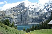
Lake Thun
Lake Thun is an Alpine lake in the Bernese Oberland in Switzerland. It took its name from the city of Thun, on its northern shore.Lake Thun's approximately 2,500 km² large catchment area frequently causes local flooding after heavy rainfalls...
and Brienz
Lake Brienz
Lake Brienz is a lake just north of the Alps, in the Canton of Berne in Switzerland. The lake took its name from the village Brienz on its northern shore. Interlaken and the villages Matten and Unterseen lie to the south west of the lake. The shores are steep, and there is almost no shallow water...
on the eastern part.
The main chain west of Gemmi Pass
Gemmi Pass
Gemmi Pass is a high mountain pass across the Bernese Alps connecting Leukerbad in the canton of Valais in Switzerland with Kandersteg in the canton of Bern....
consists mainly of a few large prominent summits (as the Wildhorn
Wildhorn
The Wildhorn is the highest peak of the Wildhorn group in the Bernese Alps. The first ascent was made by Gottlieb Samuel Studer in September 1843....
) slightly above 3000 metres, generally covered by glacier
Glacier
A glacier is a large persistent body of ice that forms where the accumulation of snow exceeds its ablation over many years, often centuries. At least 0.1 km² in area and 50 m thick, but often much larger, a glacier slowly deforms and flows due to stresses induced by its weight...
s. On the eastern part, the main chain became suddenly wider and the peaks reach over 4000 metres, in the most glaciated part of the Alps
Alps
The Alps is one of the great mountain range systems of Europe, stretching from Austria and Slovenia in the east through Italy, Switzerland, Liechtenstein and Germany to France in the west....
.
A characteristic in the orography of the Bernese Alps is, that whereas the western of that chain consists of a single series of summits with comparatively short projecting buttresses, the higher group presents a series of longitudinal ridges parallel to the axis of the main chain, and separated from each other by deep valleys that form the channels of great glaciers. Thus the Tschingel Glacier
Tschingel Glacier
The Tschingel Glacier is a 3 km long glacier situated in the Bernese Alps in the canton of Berne in Switzerland. In 1973 it had an area of 6.19 km².-External links:*...
and the Kander Glacier
Kander Glacier
The Kander Glacier is a long glacier situated in the Bernese Alps in the canton of Berne in Switzerland. In 1973 it had an area of .-External links:*...
, separate the portion of the main range lying between the Gemmi Pass
Gemmi Pass
Gemmi Pass is a high mountain pass across the Bernese Alps connecting Leukerbad in the canton of Valais in Switzerland with Kandersteg in the canton of Bern....
and the Mittaghorn from the equally high parallel range of the Doldenhorn
Doldenhorn
The Doldenhorn is a mountain in the Bernese Alps. It is located above Lake Oeschinen near Kandersteg, Switzerland....
and Blümlisalp on its northern side. To the south the same portion of the main range is divided from the still higher parallel range whose summits are the Aletschhorn
Aletschhorn
The Aletschhorn is a mountain in the Alps in Switzerland, lying within the Jungfrau-Aletsch region, which has been designated a World Heritage Site by UNESCO...
and the Bietschhorn
Bietschhorn
The Bietschhorn is a mountain in the Bernese Alps in Switzerland. The northeast and southern slopes of the mountain are part of the Jungfrau-Aletsch Protected Area listed as a UNESCO World Heritage Site that also includes the Jungfrau and the Aletsch Glacier...
by the Lötschental
Lötschental
The Lötschental is the largest valley on the northern side of the Rhône valley in the canton of Valais in Switzerland. It lies in the Bernese Alps, with the river Lonza running down the length of the valley from its source within the Langgletscher....
and the Lötschenlücke
Lötschenlücke
The Lötschenlücke is a high mountain pass in the Bernese Alps, connecting the Lötschental valley to the Aletsch Glacier in the canton of Valais in Switzerland. A hut is located above the col at 3240 m....
. To this again succeeds the deep trench through which the lower part of the Aletsch Glacier
Aletsch Glacier
The Aletsch Glacier or Great Aletsch Glacier is the largest glacier in the Alps. It has a length of about and covers more than in the eastern Bernese Alps in the Swiss canton of Valais...
flows down to the Rhone, enclosed by the minor ridge that culminates at the Eggishorn
Eggishorn
The Eggishorn is a mountain in the Bernese Alps, Valais, Switzerland.It lies within the Jungfrau-Aletsch-Bietschhorn region, which has been designated by UNESCO as a World Heritage Site. On its northern flank is the Aletsch Glacier. From the summit the view extends also to the Lepontine and Pennine...
.
It is in the central and eastern portions of the range only that crystalline rocks make their appearance; the western part is composed almost exclusively of sedimentary deposits, and the secondary ridges extending through Berne and the adjoining cantons are formed of jurassic
Jurassic
The Jurassic is a geologic period and system that extends from about Mya to Mya, that is, from the end of the Triassic to the beginning of the Cretaceous. The Jurassic constitutes the middle period of the Mesozoic era, also known as the age of reptiles. The start of the period is marked by...
, cretaceous
Cretaceous
The Cretaceous , derived from the Latin "creta" , usually abbreviated K for its German translation Kreide , is a geologic period and system from circa to million years ago. In the geologic timescale, the Cretaceous follows the Jurassic period and is followed by the Paleogene period of the...
, or eocene
Eocene
The Eocene Epoch, lasting from about 56 to 34 million years ago , is a major division of the geologic timescale and the second epoch of the Paleogene Period in the Cenozoic Era. The Eocene spans the time from the end of the Palaeocene Epoch to the beginning of the Oligocene Epoch. The start of the...
strata
Stratum
In geology and related fields, a stratum is a layer of sedimentary rock or soil with internally consistent characteristics that distinguish it from other layers...
.
Exploration
Bernese Oberland
The Bernese Oberland is the higher part of the canton of Bern, Switzerland, in the southern end of the canton: The area around Lake Thun and Lake Brienz, and the valleys of the Bernese Alps .The flag of the Bernese Oberland consists of a black eagle in a gold field The Bernese Oberland (Bernese...
, one of the portions of the Alps most visited by tourists. Since strangers first began to visit the Alps, the names of Grindelwald
Grindelwald
Grindelwald is a municipality in the Interlaken-Oberhasli administrative district in the canton of Bern in Switzerland. The village is located at above sea level in the Bernese Alps.-Winter sports:...
, Lauterbrunnen
Lauterbrunnen
Lauterbrunnen is a municipality in the Interlaken-Oberhasli administrative district in the canton of Bern in Switzerland.The municipality lies in the Lauterbrunnen Valley and comprises the villages Lauterbrunnen, Wengen, Mürren, Gimmelwald, Stechelberg and Isenfluh...
, and Interlaken
Interlaken
Interlaken is a municipality in the Interlaken-Oberhasli administrative district in the Canton of Bern in Switzerland, a well-known tourist destination in the Bernese Oberland.-History:...
have been famous. But unlike many other Alpine
Alps
The Alps is one of the great mountain range systems of Europe, stretching from Austria and Slovenia in the east through Italy, Switzerland, Liechtenstein and Germany to France in the west....
regions, which have been left to be explored by strangers, this region has been long visited by Swiss travellers and men of sciences. Among them were the brother Meyer of Aarau and Franz Joseph Hugi. They have explored most of the mountain ranges not very difficult of access, and, further than this, have attained most of the higher summits. In 1841, Louis Agassiz
Louis Agassiz
Jean Louis Rodolphe Agassiz was a Swiss paleontologist, glaciologist, geologist and a prominent innovator in the study of the Earth's natural history. He grew up in Switzerland and became a professor of natural history at University of Neuchâtel...
, with several scientific friends, established a temporary station on the Unteraar Glacier
Unteraar Glacier
The Unteraar Glacier is the larger of the two sources of the Aar river in the Bernese Alps. It emerges from the association of the Finsteraar Glacier and the Lauteraar Glacier and flows for about to the east down to the Grimselsee near the Grimsel Pass...
, and, along with scientific observations on the glaciers, started a series of expeditions. The works of Desor
Pierre Jean Édouard Desor
Pierre Jean Édouard Desor was a Swiss geologist. He associated in his early years with Louis Agassiz, studying palaeontology and glacial phenomena, and together with James David Forbes ascended the Jungfrau in 1841...
and Gottlieb Studer
Gottlieb Samuel Studer
Gottlieb Samuel Studer was a Swiss mountaineer, Notary public and draughtsman.Studer was the son of Sigmund Gottlieb Studer...
have been followed by several other publications that bear testimony to Swiss mountaineering activity. Notwithstanding the activity of their predecessors, the members of the English Alpine Club
Alpine Club (UK)
The Alpine Club was founded in London in 1857 and was probably the world's first mountaineering club. It is UK mountaineering's acknowledged 'senior club'.-History:...
have found scope for further exploits, amongst which may be reckoned the first ascents of the Aletschhorn
Aletschhorn
The Aletschhorn is a mountain in the Alps in Switzerland, lying within the Jungfrau-Aletsch region, which has been designated a World Heritage Site by UNESCO...
and the Schreckhorn
Schreckhorn
The Schreckhorn is a mountain in the Bernese Alps. It is the highest peak located entirely in the canton of Berne. The Schreckhorn is the northernmost Alpine four-thousander and the northernmost summit rising above 4,000 metres in Europe....
, and the still more arduous enterprise of crossing the range by passes, such as the Jungfraujoch
Jungfraujoch
The Jungfraujoch is a col or saddle between the Mönch and the Jungfrau in the Bernese Alps on the boundary between the cantons of Bern and Valais, inside the Jungfrau-Aletsch Protected Area....
and Eigerjoch
Eigerjoch
The Eigerjoch is a high Alpine pass lying between the Mönch and the Eiger . The lowest point on the ridge is named Nördliches Eigerjoch while another pass located closer to the Mönch is named Südliches Eigerjoch....
, which are considered amongst the most difficult in the Alps.
Jungfrau-Aletsch area
Aletsch Glacier
The Aletsch Glacier or Great Aletsch Glacier is the largest glacier in the Alps. It has a length of about and covers more than in the eastern Bernese Alps in the Swiss canton of Valais...
and the two summits of the Jungfrau
Jungfrau
The Jungfrau is one of the main summits in the Bernese Alps, situated between the cantons of Valais and Bern in Switzerland...
and Bietschhorn
Bietschhorn
The Bietschhorn is a mountain in the Bernese Alps in Switzerland. The northeast and southern slopes of the mountain are part of the Jungfrau-Aletsch Protected Area listed as a UNESCO World Heritage Site that also includes the Jungfrau and the Aletsch Glacier...
, which constitute some of the most impressive features of the site. The actual site (after the extension) includes other large glacier valleys such a the Fiescher Glacier
Fiescher Glacier
The Fiescher Glacier is a valley glacier on the south side of the Bernese Alps in the canton of Valais, Switzerland. in length, it is the second longest glacier in the Alps...
and the Aar Glaciers
Aar Glaciers
The Aar Glaciers are glaciers located at the sources of the Aar River in the Bernese Alps, Switzerland. They are constituted by two distinct glacier systems:...
.
List of peaks
Pyramidal peak
A pyramidal peak, or sometimes in its most extreme form called a glacial horn, is a mountaintop that has been modified by the action of ice during glaciation and frost weathering...
s of the Bernese Alps are:
| Name | Elevation | |
|---|---|---|
| Finsteraarhorn Finsteraarhorn The Finsteraarhorn is the highest mountain in the Bernese Alps and the highest mountain in the canton of Berne. It is also the highest summit in the Alps lying outside the main chain, or watershed. The Finsteraarhorn is the ninth highest and third most prominent peak in the Alps... | 4274 m 1 E3 m To help compare different orders of magnitude this page lists lengths between 1 kilometre and 10 kilometres .Distances shorter than 1 kilometre-Conversions:1 kilometre is equal to:* 1,000 metres... | 14,026 ft |
| Aletschhorn Aletschhorn The Aletschhorn is a mountain in the Alps in Switzerland, lying within the Jungfrau-Aletsch region, which has been designated a World Heritage Site by UNESCO... | 4182 m | 13,721 ft |
| Jungfrau Jungfrau The Jungfrau is one of the main summits in the Bernese Alps, situated between the cantons of Valais and Bern in Switzerland... | 4166 m | 13,669 ft |
| Mönch Mönch The Mönch is a mountain in the Bernese Alps, in Switzerland. Together with the Eiger and the Jungfrau it forms a highly recognisable group of mountains visible from far away.... | 4105 m | 13,468 ft |
| Schreckhorn Schreckhorn The Schreckhorn is a mountain in the Bernese Alps. It is the highest peak located entirely in the canton of Berne. The Schreckhorn is the northernmost Alpine four-thousander and the northernmost summit rising above 4,000 metres in Europe.... | 4080 m | 13,386 ft |
| Grosses Fiescherhorn Fiescherhorn The Gross Fiescherhorn is a mountain in the Bernese Alps range of the Swiss Alps. At 4,049 metres above sea level, its summit culminates over the whole Fiescherhorn massif, which is also composed of the slightly lower Hinter Fiescherhorn and Klein Fiescherhorn... | 4049 m | 13,285 ft |
| Grünhorn Grünhorn The Grünhorn is a mountain in the Bernese Alps range of the Swiss Alps. It is located on the ridge between the two largest glaciers of the Alps: the Aletsch Glacier to the west and the Fiescher Glacier to the east... | 4043 m | 13,264 ft |
| Lauteraarhorn Lauteraarhorn The Lauteraarhorn is a peak of the Aarmassif in the Bernese Alps in Switzerland. It lies close to the Schreckhorn and the Finsteraarhorn... | 4042 m | 13,261 ft |
| Hinter Fiescherhorn Hinter Fiescherhorn The Hinter Fiescherhorn is a minor summit near the Gross Fiescherhorn. It is located in the Swiss canton of Valais near the border with the canton of Berne.... | 4025 m | 13,205 ft |
| Gletscherhorn Gletscherhorn The Gletscherhorn is a mountain to the south of the Jungfrau in the Bernese Alps. It forms the eastern edge of the Lauterbrunnen Wall.... | 3983 m | 13,067 ft |
| Eiger Eiger The Eiger is a mountain in the Bernese Alps in Switzerland. It is the easternmost peak of a ridge crest that extends across the Mönch to the Jungfrau at 4,158 m... | 3970 m | 13,025 ft |
| Rottalhorn Rottalhorn The Rottalhorn is a mountain in the Bernese Alps. It lies 600m south of the Jungfrau-External links:*... | 3969 m | 13,031 ft |
| Ebnefluh Ebnefluh The Ebnefluh is a mountain in the Bernese Alps in Switzerland. It lies towards the eastern end of the Lauterbrunnen Wall.-External links:*... | 3962 m | 12,999 ft |
| Agassizhorn Agassizhorn The Agassizhorn is a mountain in the Bernese Alps of Switzerland. It was named after the geologist and explorer Louis Agassiz.... | 3946 m | 12,946 ft |
| Bietschhorn Bietschhorn The Bietschhorn is a mountain in the Bernese Alps in Switzerland. The northeast and southern slopes of the mountain are part of the Jungfrau-Aletsch Protected Area listed as a UNESCO World Heritage Site that also includes the Jungfrau and the Aletsch Glacier... | 3934 m | 12,907 ft |
| Trugberg Trugberg The Trugberg is a mountain in the Bernese Alps in Switzerland. It is located above the Konkordiaplatz where the névé of the Jungfraufirn on the west side and the Ewigschneefeld on the east side converge to form the Aletsch Glacier. The Trugberg lies south of the Mönch.In 1841 a group of explorers... | 3933 m | 12,904 ft |
| Klein Grünhorn Klein Grünhorn Klein Grünhorn is a mountain in the Bernese Alps, situated north of Gross Grünhorn in the canton of Valais, Switzerland.-External links:*... | 3913 m | 12,838 ft |
| Gross Wannenhorn Gross Wannenhorn The Gross Wannenhorn is a mountain in the Bernese Alps. It is located in the canton of Valais near the village of Fiesch. The mountain separates the Aletsch Glacier from the Fiescher Glacier.... | 3905 m | 12,812 ft |
| Klein Fiescherhorn Klein Fiescherhorn Klein Fiescherhorn is a mountain in the Bernese Alps, situated east of the Gross Fiescherhorn on the border between the cantons of Berne and Valais in Switzerland.-External links:*... | 3895 m | 13,779 ft |
| Mittaghorn Mittaghorn The Mittaghorn is a mountain in the Bernese Alps in Switzerland, situated in the middle of the Lauterbrunnen Wall.-External links:*... | 3892 m | 12,769 ft |
| Fiescher Gabelhorn Fiescher Gabelhorn The Fiescher Gabelhorn is a mountain in the Bernese Alps in Switzerland.-External links:*... | 3876 m | 12,717 ft |
| Nesthorn Nesthorn The Nesthorn is a mountain in the Bernese Alps. It is located in the Swiss canton of Valais north of Brig. The mountain lies between the Oberaletsch Glacier on the north and east side and the Gredetschtal on the south side. It is part of the subrange of the Bernese Alps that culminates at the... | 3820 m | 12,533 ft |
| Dreieckhorn Dreieckhorn Dreieckhorn is a mountain in the Bernese Alps in Switzerland.-External links:*... | 3811 m | 12,503 ft |
| Schinhorn Schinhorn Schinhorn is a mountain in the Bernese Alps in Switzerland.-External links:*... | 3797 m | 12,457 ft |
| Breithorn (Lötschental) Breithorn (Lötschental) The Breithorn is a mountain in the Bernese Alps in Switzerland.-External links:*... | 3785 m | 12,418 ft |
| Breithorn (Lauterbrunnen) Breithorn (Lauterbrunnen) The Lauterbrunnen Breithorn is a mountain in the Bernese Alps of Switzerland, situated at the western end of the Lauterbrunnen Wall.-External links:*... | 3779 m | 12,399 ft |
| Grosshorn Grosshorn The Grosshorn is a mountain in the Bernese Alps in Switzerland, situated in the middle of the Lauterbrunnen Wall.-External links:*... | 3754 m | 12,316 ft |
| Sattelhorn Sattelhorn Sattelhorn is a mountain in the Bernese Alps in Switzerland.-External links:*... | 3745 m | 12,287 ft |
| Wetterhorn Wetterhorn The Wetterhorn is a mountain in the Swiss Alps close to the village of Grindelwald. First climbed in 1844, the 1854 ascent by Alfred Wills and party is more celebrated and is generally regarded to have marked the beginning of the golden age of alpinism.The mountain is composed of three distinct... | 3708 m | 12,166 ft |
| Balmhorn Balmhorn The Balmhorn is a mountain in the Bernese Alps in Switzerland. Its summit ridge lies on the border between the cantons of Berne and the Valais.... | 3698 m | 12,133 ft |
| Silberhorn Silberhorn The Silberhorn is a pyramid-shaped mountain in the Bernese Alps, to the northwest of the Jungfrau of which it is a satellite peak.A first attempt to reach the summit of the Silberhorn was made in June 1863 by M. v. Fellenberg from the Stufensteinalp on the east side of the valley of Lauterbrunnen... | 3695 m | 12,122 ft |
| Blüemlisalphorn | 3671 m | 12,044 ft |
| Doldenhorn Doldenhorn The Doldenhorn is a mountain in the Bernese Alps. It is located above Lake Oeschinen near Kandersteg, Switzerland.... | 3647 m | 11,966 ft |
| Altels | 3636 m | 11,930 ft |
| Tschingelhorn Tschingelhorn The Tschingelhorn is a mountain in the Bernese Alps in Switzerland.The first ascent was made by Heinrich Feuz, W. H. Hawker, and Ulrich and Christian Lauener on 6 September 1865.W. A. B. Coolidge's dog 'Tschingel' The Tschingelhorn (3,562 m) is a mountain in the Bernese Alps in Switzerland.The... | 3562 m | 11,686 ft |
| Gspaltenhorn Gspaltenhorn The Gspaltenhorn is a mountain in the Bernese Alps.... | 3442 m | 11,293 ft |
| Gross Hühnerstock | 3348 m | 10,985 ft |
| Ewigschneehorn Ewigschneehorn The Ewigschneehorn is a mountain in the Bernese Alps.It is 3329 meters high. It is near the most isolated place in Switzerland.... | 3331 m | 10,929 ft |
| Ritzlihorn Ritzlihorn Ritzlihorn is a mountain in the Bernese Alps in Switzerland.-External links:*... | 3282 m | 10,768 ft |
| Wildhorn Wildhorn The Wildhorn is the highest peak of the Wildhorn group in the Bernese Alps. The first ascent was made by Gottlieb Samuel Studer in September 1843.... | 3248 m | 10,656 ft |
| Wildstrubel Wildstrubel The Wildstrubel is a mountain in the Bernese Alps in Switzerland on the border between the Canton of Berne and the Canton of Valais.The mountain has three summits, all of similar height:... | 3243 m | 10,640 ft |
| Diablerets Diablerets The Diablerets is a mountain in the Bernese Alps, located between the cantons of Valais and Vaud, in the western French-speaking part of Switzerland. The summit is 3,210 metres high, making it the highest mountain in the canton of Vaud... | 3210 m | 10,650 ft |
| Wellhorn Wellhorn Wellhorn is a mountain in the Bernese Alps in Switzerland.-External links:*... | 3196 m | 10,486 ft |
| Mättenberg Mättenberg Mättenberg is a mountain in the Bernese Alps in Switzerland.-External links:*... | 3107 m | 10,194 ft |
| Löffelhorn Löffelhorn Löffelhorn is a mountain in the Bernese Alps in Switzerland.-External links:*... | 3098 m | 10,165 ft |
| Grand Muveran Grand Muveran The Grand Muveran is a mountain in the Bernese Alps. At 3,051 metres it is the highest summit lying west of Pas de Cheville and the westernmost three-thousander of the Bernese Alps. It is located on the border between Vaud and Valais. On the latter side is the village of Ovronnaz where the easiest... | 3061 m | 10,043 ft |
| Sparrhorn Sparrhorn Sparrhorn is a mountain in the Bernese Alps in Switzerland.-External links:*... | 3026 m | 9928 ft |
| Torrenthorn Torrenthorn -External links:* An account of the walk up the Torrenthorn from the cablecar station at the Rinderhutte can be found here http://steverabone.com/more%20swiss%20walks/torrenthorn.htm... | 3003 m | 9853 ft |
| Dent de Morcles Dent de Morcles The Dent de Morcles is a 2,969 metres high mountain located at western end of the Bernese Alps, overlooking the Rhone between Martigny and St. Maurice.... | 2980 m | 9777 ft |
| Schilthorn Schilthorn The Schilthorn is a 2,970 metre high summit in the Bernese Alps in Switzerland, above Mürren.It has a panoramic view which spans from the Titlis, Jungfrau, Mönch, Eiger, over the Bernese Alps and the Jura mountains up to the Vosges Mountains and the Black Forest... | 2973 m | 9754 ft |
| Eggishorn Eggishorn The Eggishorn is a mountain in the Bernese Alps, Valais, Switzerland.It lies within the Jungfrau-Aletsch-Bietschhorn region, which has been designated by UNESCO as a World Heritage Site. On its northern flank is the Aletsch Glacier. From the summit the view extends also to the Lepontine and Pennine... | 2934 m | 9626 ft |
| Uri-Rotstock | 2932 m | 9620 ft |
| Schwarzhorn Schwarzhorn (Grindelwald) Schwarzhorn is the highest mountain in the Commune of Brienz in the Bernese Alps in Switzerland and is regarded as one of the most stunning look-out peaks in the Bernese Oberland.-External links:*... | 2930 m | 9613 ft |
| Gross Sidelhorn Sidelhorn The Sidelhorn is a mountain in the Bernese Alps in Switzerland.-External links:*... | 2881 m | 9452 ft |
| Albristhorn Albristhorn The Albristhorn is a mountain in the Bernese Alps, overlooking Lenk and Adelboden in the canton of Bern. It is the highest summit of the chain lying between the Wildstrubel and Lake Thun and which is the watershed between the Simme and the Kander.The summit is accessible to experienced hikers with... | 2764 m | 9069 ft |
| Faulhorn Faulhorn The Faulhorn is a mountain in the Bernese Alps in Switzerland.-External links:*... | 2683 m | 8803 ft |
| Gummfluh Gummfluh The Gummfluh is a mountain in the western Bernese Alps, located on the border between the Swiss cantons of Vaud and Berne. It is the highest peak in the chain of mountains on the south side of the Pays d'Enhaut and it lies approximately halfway between Château d'Oex and Gstaad. The northern slopes... | 2461 m | 8074 ft |
| Sulegg Sulegg The Sulegg is a mountain in the Bernese Alps in Switzerland.-External links:*... | 2412 m | 7914 ft |
| Vanil Noir Vanil Noir Vanil Noir is the highest mountain of the Fribourg Prealps in Switzerland. It forms the border between the Canton of Fribourg and Vaud.Vanil Noir is the highest point of the canton of Fribourg.... | 2395 m | 7858 ft |
| Niesen Niesen The Niesen is a mountain, located in the Bernese Oberland region of the Swiss Alps, overlooking Lake Thun and is often called the Swiss Pyramid.-Overview:... | 2366 m | 7763 ft |
| Brienzer Rothorn Brienzer Rothorn The Brienzer Rothorn is a mountain in the Swiss Alps on the border between the cantons of Lucerne, Berne and Obwalden. The summit can be reached from Brienz by the Brienz Rothorn Bahn and from Sörenberg by a cable car.-External links:*... | 2351 m | 7714 ft |
| Tour d'Aï Tour d'Aï The Tour d'Aï is a mountain in the western Bernese Alps, overlooking Leysin in the canton of Vaud. It is located near the Tour de Mayen, on the range lying between the Rhone and Col des Mosses, south of Lake Geneva, from where both summits can be easily seen.... | 2334 m | 7658 ft |
| Hohgant Hohgant Hohgant is a mountain in the Bernese Alps, located in the Canton of Berne, Switzerland.Several caves developing in the Urgonian limestone formation have their entrances on the Hohgant mountain. The F1 cave is connected to the Siebenhengste cave network.-External links:*... | 2202 m | 7225 ft |
| Stockhorn Stockhorn The Stockhorn is a mountain in the Bernese Alps, above the town of Erlenbach in Simmetal.The Stockhorn is 2190 m high and is accessible via cable car and/or walking during 3 hours 30 minutes from the Oberstockensee. It has a restaurant at the top and is a good starting point for many hikes... | 2192 m | 7192 ft |
| Kaiseregg Kaiseregg The Kaiseregg is a mountain in the Bernese Alps, overlooking Schwarzsee in the canton of Fribourg. Its summit, which can be accessed by trail, is located a few hundreeds metres from the border with the canton of Bern.... | 2189 m | 7182 ft |
| Le Chamossaire Le Chamossaire Le Chamossaire is a mountain in the western Bernese Alps, overlooking Villars-sur-Ollon in the canton of Vaud. The mountain is part of a ski area and its summit is easily accessible from Bretaye with the Bex–Villars–Bretaye railway.... | 2116 m | 6943 ft |
| Rochers de Naye Rochers de Naye Rochers de Naye is a mountain above Montreux, from where the Chemin de fer Montreux-Glion-Rochers-de-Naye leads to its peak.In addition, it is also possible to access the summit by driving to Col de Jaman and then making the 2-3 hr hike to the peak.... | 1740 m | 5710 ft |
| Le Moléson Le Moléson The Moléson is a mountain in the Alps in Switzerland . A cable car station is located near the summit at 1,982 metres as well as a meteorological station.-Weather:-External links:*... | 2006 m | 6582 ft |
| Dent de Jaman Dent de Jaman Dent de Jaman is a mountain above Montreux, situated north of Rochers de Naye.... | 1879 m | 6165 ft |
Glaciers
Main glacierGlacier
A glacier is a large persistent body of ice that forms where the accumulation of snow exceeds its ablation over many years, often centuries. At least 0.1 km² in area and 50 m thick, but often much larger, a glacier slowly deforms and flows due to stresses induced by its weight...
s:
- Aletsch GlacierAletsch GlacierThe Aletsch Glacier or Great Aletsch Glacier is the largest glacier in the Alps. It has a length of about and covers more than in the eastern Bernese Alps in the Swiss canton of Valais...
- Fiescher GlacierFiescher GlacierThe Fiescher Glacier is a valley glacier on the south side of the Bernese Alps in the canton of Valais, Switzerland. in length, it is the second longest glacier in the Alps...
- Unteraar GlacierUnteraar GlacierThe Unteraar Glacier is the larger of the two sources of the Aar river in the Bernese Alps. It emerges from the association of the Finsteraar Glacier and the Lauteraar Glacier and flows for about to the east down to the Grimselsee near the Grimsel Pass...
- Lower Grindelwald GlacierLower Grindelwald GlacierThe Lower Grindelwald Glacier is the western one and the largest of the two Grindelwald Glaciers in the Bernese Alps, south of Grindelwald, the other being the Upper Grindelwald Glacier.The Lower Grindelwald Glacier covers an area of ....
- Oberaletsch GlacierOberaletsch GlacierThe Oberaletsch Glacier is a valley glacier on the south side of the Bernese Alps, in the canton of Valais. It has a length of with an average width of just under and an area of about ....
- Mittelaletsch GlacierMittelaletsch GlacierThe Mittelaletsch Glacier is a 5 km long glacier situated in the Bernese Alps in the canton of Valais in Switzerland. In 1973 it had an area of 8.31 km².-External links:*...
- Gauli GlacierGauli GlacierThe Gauli Glacier is a long glacier situated in the Bernese Alps in the canton of Berne in Switzerland. In 1973 it had an area of .Famous for an plane crash of an American plane 1946 and its rescue mission. -External links:*...
- Lang GlacierLang GlacierThe Lang Glacier is a long glacier situated in the Bernese Alps in the canton of Valais in Switzerland. In 1973 it had an area of .-External links:*...
- Upper Grindelwald GlacierUpper Grindelwald GlacierThe Upper Grindelwald Glacier is one of the two valley glaciers south of Grindelwald on the northern side of the Bernese Alps, in the Canton of Berne...
- Kander GlacierKander GlacierThe Kander Glacier is a long glacier situated in the Bernese Alps in the canton of Berne in Switzerland. In 1973 it had an area of .-External links:*...
- Tschingel GlacierTschingel GlacierThe Tschingel Glacier is a 3 km long glacier situated in the Bernese Alps in the canton of Berne in Switzerland. In 1973 it had an area of 6.19 km².-External links:*...
- Rosenlaui GlacierRosenlaui GlacierThe Rosenlaui Glacier is a 5-km-long glacier situated in the Bernese Alps in the canton of Berne in Switzerland. In 1973 it had an area of 6.14 km².-External links:*...
- Plaine MortePlaine MorteThe Plaine Morte is a glacier located at an elevation of , in the canton of Bern in Switzerland. The ice field, which covers , is located below the mountain of Wildstrubel in the Bernese Alps....
- Wildstrubel GlacierWildstrubel GlacierThe Wildstrubel Glacier is a 2.5 km long glacier situated in the Bernese Alps in the canton of Valais in Switzerland. In 1973 it had an area of 4.8 km².-External links:*...
- Tsanfleuron GlacierTsanfleuron GlacierThe Tsanfleuron Glacier is a long glacier situated in the western Bernese Alps in the cantons of Valais and Vaud in Switzerland. In 1973 it had an area of ....
- Diablerets GlacierDiablerets GlacierThe Diablerets Glacier is a glacier situated on the summit of Les Diablerets in the Bernese Alps. It covers an area of approximatively 1 km².The Diablerets Glacier is often confused with the nearby much larger and popular Tsanfleuron Glacier....
List of passes
The chief passesMountain pass
A mountain pass is a route through a mountain range or over a ridge. If following the lowest possible route, a pass is locally the highest point on that route...
of the Bernese Alps are:
| Mountain pass | location | type | elevation | |
|---|---|---|---|---|
| Lauitor | Lauterbrunnen Lauterbrunnen Lauterbrunnen is a municipality in the Interlaken-Oberhasli administrative district in the canton of Bern in Switzerland.The municipality lies in the Lauterbrunnen Valley and comprises the villages Lauterbrunnen, Wengen, Mürren, Gimmelwald, Stechelberg and Isenfluh... to the Eggishorn Eggishorn The Eggishorn is a mountain in the Bernese Alps, Valais, Switzerland.It lies within the Jungfrau-Aletsch-Bietschhorn region, which has been designated by UNESCO as a World Heritage Site. On its northern flank is the Aletsch Glacier. From the summit the view extends also to the Lepontine and Pennine... | snow | 3700 m | 12,140 ft |
| Mönchjoch | Grindelwald Grindelwald Grindelwald is a municipality in the Interlaken-Oberhasli administrative district in the canton of Bern in Switzerland. The village is located at above sea level in the Bernese Alps.-Winter sports:... to the Eggishorn Eggishorn The Eggishorn is a mountain in the Bernese Alps, Valais, Switzerland.It lies within the Jungfrau-Aletsch-Bietschhorn region, which has been designated by UNESCO as a World Heritage Site. On its northern flank is the Aletsch Glacier. From the summit the view extends also to the Lepontine and Pennine... | snow | 3560 m | 11,680 ft |
| Jungfraujoch Jungfraujoch The Jungfraujoch is a col or saddle between the Mönch and the Jungfrau in the Bernese Alps on the boundary between the cantons of Bern and Valais, inside the Jungfrau-Aletsch Protected Area.... | Wengernalp Wengernalp The Wengernalp is an alpine meadow at an elevation of 1874 m, between Wengen and Kleine Scheidegg in the Swiss Alps. It can be reached on foot, by Wengernalpbahn to Wengernalp railway station from Wengen or by skiing from Kleine Scheidegg.... to the Eggishorn Eggishorn The Eggishorn is a mountain in the Bernese Alps, Valais, Switzerland.It lies within the Jungfrau-Aletsch-Bietschhorn region, which has been designated by UNESCO as a World Heritage Site. On its northern flank is the Aletsch Glacier. From the summit the view extends also to the Lepontine and Pennine... | snow | 3470 m | 11,385 ft |
| Strahlegg Pass | Grindelwald Grindelwald Grindelwald is a municipality in the Interlaken-Oberhasli administrative district in the canton of Bern in Switzerland. The village is located at above sea level in the Bernese Alps.-Winter sports:... to the Grimsel Pass Grimsel Pass Grimsel Pass is a Swiss high mountain pass.-Position:It connects the valley of the Rhone River in the canton of Valais and the Haslital in the canton of Bern.... | snow | 3351 m | 10,995 ft |
| Grünhornlücke Grünhornlücke The Grünhornlücke is a high mountain pass in the eastern Bernese Alps, connecting the Aletsch Glacier and the Fiescher Glacier in the canton of Valais in Switzerland.... | Great Aletsch Glacier to the Fiescher Glacier Fiescher Glacier The Fiescher Glacier is a valley glacier on the south side of the Bernese Alps in the canton of Valais, Switzerland. in length, it is the second longest glacier in the Alps... | snow | 3305 m | 10,844 ft |
| Oberaarjoch Oberaarjoch The Oberaarjoch is a high mountain pass across the eastern Bernese Alps, connecting the Fiescher Glacier in the canton of Valais with the Oberaar Glacier in the canton of Berne in Switzerland.... | Grimsel to the Eggishorn Eggishorn The Eggishorn is a mountain in the Bernese Alps, Valais, Switzerland.It lies within the Jungfrau-Aletsch-Bietschhorn region, which has been designated by UNESCO as a World Heritage Site. On its northern flank is the Aletsch Glacier. From the summit the view extends also to the Lepontine and Pennine... | snow | 3233 m | 10,607 ft |
| Gauli Pass | Grimsel to Meiringen Meiringen -References:... | snow | 3206 m | 10,519 ft |
| Petersgrat Petersgrat -External links:*... | Lauterbrunnen Lauterbrunnen Lauterbrunnen is a municipality in the Interlaken-Oberhasli administrative district in the canton of Bern in Switzerland.The municipality lies in the Lauterbrunnen Valley and comprises the villages Lauterbrunnen, Wengen, Mürren, Gimmelwald, Stechelberg and Isenfluh... to the Lötschental Lötschental The Lötschental is the largest valley on the northern side of the Rhône valley in the canton of Valais in Switzerland. It lies in the Bernese Alps, with the river Lonza running down the length of the valley from its source within the Langgletscher.... | snow | 3205 m | 10,516 ft |
| Lötschenlücke Lötschenlücke The Lötschenlücke is a high mountain pass in the Bernese Alps, connecting the Lötschental valley to the Aletsch Glacier in the canton of Valais in Switzerland. A hut is located above the col at 3240 m.... | Lötschental Lötschental The Lötschental is the largest valley on the northern side of the Rhône valley in the canton of Valais in Switzerland. It lies in the Bernese Alps, with the river Lonza running down the length of the valley from its source within the Langgletscher.... to the Eggishorn Eggishorn The Eggishorn is a mountain in the Bernese Alps, Valais, Switzerland.It lies within the Jungfrau-Aletsch-Bietschhorn region, which has been designated by UNESCO as a World Heritage Site. On its northern flank is the Aletsch Glacier. From the summit the view extends also to the Lepontine and Pennine... | snow | 3204 m | 10,512 ft |
| Lauteraarsattel | Grindelwald Grindelwald Grindelwald is a municipality in the Interlaken-Oberhasli administrative district in the canton of Bern in Switzerland. The village is located at above sea level in the Bernese Alps.-Winter sports:... to the Grimsel | snow | 3156 m | 10,355 ft |
| Beichgrat | Lötschental Lötschental The Lötschental is the largest valley on the northern side of the Rhône valley in the canton of Valais in Switzerland. It lies in the Bernese Alps, with the river Lonza running down the length of the valley from its source within the Langgletscher.... to the Belalp Belalp Belalp is a village and ski resort in the Swiss canton of Valais, 2'100 m above sea level, in the municipality of Naters.Belalp is a car free village which can be reached by cable car from the village of Blatten. Because of its altitude the place is also a vantage point offering view of Dom and... | snow | 3136 m | 10,289 ft |
| Lammernjoch | Lenk Lenk Lenk may refer to:Places:* Lenk im Simmental, a municipality in the district of Obersimmental in the canton of Bern in SwitzerlandPeople:* Arthur Lenk, an Israeli diplomat* Maria Lenk, a Brazilian swimmer... to the Gemmi | snow | 3132 m | 10,276 ft |
| Triftlimmi | Rhone Glacier Rhône Glacier The Rhone Glacier, or sometimes Rhône Glacier is a glacier in the Swiss Alps and the source of the Rhone River and one of the primary contributors to Lake Geneva in the far eastern end of the Swiss canton of Valais... to the Gadmental | snow | 3109 m | 10,200 ft |
| Sustenlimmi | Stein Alp to Göschenen Göschenen Göschenen a village in the canton of Uri in Switzerland.-History:Göschenen is first mentioned in 1280 as Geschenden. In 1290 it was mentioned as Gescheldun, then in 1294 as Geschenen and in 1429 as ze Gestinen.-Geography:... | snow | 3103 m | 10,181 ft |
| Gamchilucke | Kiental Kiental Kiental is a village in the Bernese Oberland in the canton of Bern in Switzerland. Kiental enters the annals of world history due to the Kiental Conference held in 1916.-History:Kiental Conference... to Lauterbrunnen Lauterbrunnen Lauterbrunnen is a municipality in the Interlaken-Oberhasli administrative district in the canton of Bern in Switzerland.The municipality lies in the Lauterbrunnen Valley and comprises the villages Lauterbrunnen, Wengen, Mürren, Gimmelwald, Stechelberg and Isenfluh... | snow | 2833 m | 9295 ft |
| Tschiugel Pass | Lauterbrunnen Lauterbrunnen Lauterbrunnen is a municipality in the Interlaken-Oberhasli administrative district in the canton of Bern in Switzerland.The municipality lies in the Lauterbrunnen Valley and comprises the villages Lauterbrunnen, Wengen, Mürren, Gimmelwald, Stechelberg and Isenfluh... to Kandersteg Kandersteg Kandersteg is a municipality in the Frutigen-Niedersimmental administrative district in the canton of Bern in Switzerland. It is located along the valley of the River Kander, west of the Jungfrau massif. It is noted for its spectacular mountain scenery and sylvan alpine landscapes. Tourism is a... | snow | 2824 m | 9265 ft |
| Hohtürli Pass | Kandersteg Kandersteg Kandersteg is a municipality in the Frutigen-Niedersimmental administrative district in the canton of Bern in Switzerland. It is located along the valley of the River Kander, west of the Jungfrau massif. It is noted for its spectacular mountain scenery and sylvan alpine landscapes. Tourism is a... to the Kiental Kiental Kiental is a village in the Bernese Oberland in the canton of Bern in Switzerland. Kiental enters the annals of world history due to the Kiental Conference held in 1916.-History:Kiental Conference... | foot path | 2707 m | 8882 ft |
| Lötschen Pass | Kandersteg Kandersteg Kandersteg is a municipality in the Frutigen-Niedersimmental administrative district in the canton of Bern in Switzerland. It is located along the valley of the River Kander, west of the Jungfrau massif. It is noted for its spectacular mountain scenery and sylvan alpine landscapes. Tourism is a... to the Lötschental Lötschental The Lötschental is the largest valley on the northern side of the Rhône valley in the canton of Valais in Switzerland. It lies in the Bernese Alps, with the river Lonza running down the length of the valley from its source within the Langgletscher.... | snow | 2695 m | 8842 ft |
| Sefinenfurgge | Lauterbrunnen Lauterbrunnen Lauterbrunnen is a municipality in the Interlaken-Oberhasli administrative district in the canton of Bern in Switzerland.The municipality lies in the Lauterbrunnen Valley and comprises the villages Lauterbrunnen, Wengen, Mürren, Gimmelwald, Stechelberg and Isenfluh... to the Kiental Kiental Kiental is a village in the Bernese Oberland in the canton of Bern in Switzerland. Kiental enters the annals of world history due to the Kiental Conference held in 1916.-History:Kiental Conference... | foot path | 2616 m | 8583 ft |
| Wendenjoch | Engelberg Engelberg Engelberg is a village in the canton of Obwalden in Switzerland. Engelberg has a population of . , 21.0% of the population was made up of foreign nationals.It is the leading mountain resort in central Switzerland... to the Gadmental | snow | 2604 m | 8544 ft |
| Furtwangsattel | Guttannen Guttannen Guttannen is a municipality in the Interlaken-Oberhasli administrative district in the canton of Bern in Switzerland.- Geography :Guttannen lies in the Bernese Oberland near Grimsel Pass. It is the highest settlement in the Haslital... to the Gadmental | foot path | 2558 m | 8393 ft |
| Furka Pass Furka Pass Furka Pass is a high mountain pass in the Swiss Alps connecting Gletsch, Valais with Realp, Uri. The Furka-Oberalp-Bahn line through the Furka Tunnel bypasses the pass... | Rhône Glacier Rhône Glacier The Rhone Glacier, or sometimes Rhône Glacier is a glacier in the Swiss Alps and the source of the Rhone River and one of the primary contributors to Lake Geneva in the far eastern end of the Swiss canton of Valais... to Andermatt Andermatt Andermatt is a municipality in the canton of Uri in Switzerland.With Realp and Hospental, it is located in the Urseren valley, south of Altdorf.-Geography:... | road | 2436 m | 7992 ft |
| Rawil Pass | Sion Sion, Switzerland Sion is the capital of the Swiss canton of Valais. it had a population of .Landmarks include the Basilique de Valère and Château de Tourbillon. Sion has an airfield for civilian and military use, which, because of its location in a valley, causes a reasonable amount of noise pollution. FC Sion... to Lenk im Simmental Lenk im Simmental Lenk im Simmental is a municipality in the Obersimmental-Saanen administrative district in the canton of Bern in Switzerland.-History:Lenk is first mentioned in 1370 as An der Leng.... | bridle path | 2415 m | 7924 ft |
| Gemmi Pass Gemmi Pass Gemmi Pass is a high mountain pass across the Bernese Alps connecting Leukerbad in the canton of Valais in Switzerland with Kandersteg in the canton of Bern.... | Kandersteg Kandersteg Kandersteg is a municipality in the Frutigen-Niedersimmental administrative district in the canton of Bern in Switzerland. It is located along the valley of the River Kander, west of the Jungfrau massif. It is noted for its spectacular mountain scenery and sylvan alpine landscapes. Tourism is a... to Leukerbad Leukerbad Leukerbad is a municipality in the district of Leuk in the canton of Valais in Switzerland.- History :The story of Leukerbad dates back to the 4th century B.C. Graves and ceramics attest the presence of habitation in Leukerbad... | bridle path | 2329 m | 7641 ft |
| Surenen Pass | Engelberg Engelberg Engelberg is a village in the canton of Obwalden in Switzerland. Engelberg has a population of . , 21.0% of the population was made up of foreign nationals.It is the leading mountain resort in central Switzerland... to Altdorf | foot path | 2305 m | 7563 ft |
| Susten Pass Susten Pass Susten Pass is a mountain pass in the Swiss Alps. The pass road, built from 1938–1945, connects Innertkirchen in the canton of Bern with Wassen in the canton of Uri... | Meiringen Meiringen -References:... to Wassen Wassen Wassen is a municipality in the canton of Uri in Switzerland.-Geography:Wassen has an area, , of . Of this area, 12.5% is used for agricultural purposes, while 18.2% is forested. Of the rest of the land, 1.1% is settled and the remainder is non-productive... | road | 2262 m | 7422 ft |
| Sanetsch Pass | Sion Sion, Switzerland Sion is the capital of the Swiss canton of Valais. it had a population of .Landmarks include the Basilique de Valère and Château de Tourbillon. Sion has an airfield for civilian and military use, which, because of its location in a valley, causes a reasonable amount of noise pollution. FC Sion... to Saanen Saanen Saanen is a municipality in the canton of Bern in Switzerland. It is the capital of the Obersimmental-Saanen administrative district.-Geography:Saanen has an area of . Of this area, 52.8% is used for agricultural purposes, while 33.6% is forested... | bridle path | 2234 m | 7331 ft |
| Joch Pass | Meiringen Meiringen -References:... to Engelberg Engelberg Engelberg is a village in the canton of Obwalden in Switzerland. Engelberg has a population of . , 21.0% of the population was made up of foreign nationals.It is the leading mountain resort in central Switzerland... | bridle path | 2215 m | 7267 ft |
| Grimsel Pass Grimsel Pass Grimsel Pass is a Swiss high mountain pass.-Position:It connects the valley of the Rhone River in the canton of Valais and the Haslital in the canton of Bern.... | Meiringen Meiringen -References:... to the Rhone Glacier Rhône Glacier The Rhone Glacier, or sometimes Rhône Glacier is a glacier in the Swiss Alps and the source of the Rhone River and one of the primary contributors to Lake Geneva in the far eastern end of the Swiss canton of Valais... | road | 2164 m | 7100 ft |
| Kleine Scheidegg Kleine Scheidegg The Kleine Scheidegg is a high mountain pass below and between the Eiger and Lauberhorn peaks in the Bernese Oberland, Switzerland. It connects Grindelwald with Lauterbrunnen. The name means "minor watershed", even though it is actually higher than the neighbouring Grosse Scheidegg... | Grindelwald Grindelwald Grindelwald is a municipality in the Interlaken-Oberhasli administrative district in the canton of Bern in Switzerland. The village is located at above sea level in the Bernese Alps.-Winter sports:... to Lauterbrunnen Lauterbrunnen Lauterbrunnen is a municipality in the Interlaken-Oberhasli administrative district in the canton of Bern in Switzerland.The municipality lies in the Lauterbrunnen Valley and comprises the villages Lauterbrunnen, Wengen, Mürren, Gimmelwald, Stechelberg and Isenfluh... | path, railway | 2064 m | 6772 ft |
| Col de Cheville | Sion Sion, Switzerland Sion is the capital of the Swiss canton of Valais. it had a population of .Landmarks include the Basilique de Valère and Château de Tourbillon. Sion has an airfield for civilian and military use, which, because of its location in a valley, causes a reasonable amount of noise pollution. FC Sion... to Bex Bex Bex is a municipality in the canton of Vaud, Switzerland, located in the district of Aigle. It is a few miles south of its sister town municipality of Aigle.-The Bex Salt Mine:Bex is the site of a famous salt mine.... | bridle path | 2049 m | 6723 ft |
| Grosse Scheidegg Grosse Scheidegg Grosse Scheidegg is a high mountain pass in the Bernese Alps in Switzerland, connecting Grindelwald and Meiringen.The road over the pass is open only to bus traffic... | Grindelwald Grindelwald Grindelwald is a municipality in the Interlaken-Oberhasli administrative district in the canton of Bern in Switzerland. The village is located at above sea level in the Bernese Alps.-Winter sports:... to Meiringen Meiringen -References:... | bridle path | 1967 m | 6454 ft |
| Col de Jaman | Montreux Montreux Montreux is a municipality in the district of Riviera-Pays-d'Enhaut in the canton of Vaud in Switzerland.It is located on Lake Geneva at the foot of the Alps and has a population, , of and nearly 90,000 in the agglomeration.- History :... to Montbovon | mule path railway tunnel | 1516 m | 4974 ft |
| Brünig Pass Brünig Pass Brünig Pass connects the Bernese Oberland and central Switzerland, linking Meiringen in the canton of Bern and Lungern in the canton of Obwalden.Rail services are provided by the Zentralbahn between Luzern and Interlaken.-See also:... | Meiringen Meiringen -References:... to Lucerne Lucerne Lucerne is a city in north-central Switzerland, in the German-speaking portion of that country. Lucerne is the capital of the Canton of Lucerne and the capital of the district of the same name. With a population of about 76,200 people, Lucerne is the most populous city in Central Switzerland, and... | road, railway | 1035 m | 3396 ft |
External links
- Bernese Alps at NASA Earth ObservatoryNASA Earth ObservatoryNASA Earth Observatory is an online publishing outlet for NASA which was created in 1999. It is the principal source of satellite imagery and other scientific information pertaining to the climate and the environment which are being provided by NASA for consumption by the general public...