
Weisshorn
Encyclopedia
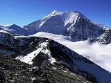
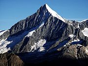
The Weisshorn (German
German language
German is a West Germanic language, related to and classified alongside English and Dutch. With an estimated 90 – 98 million native speakers, German is one of the world's major languages and is the most widely-spoken first language in the European Union....
, lit. White Peak) is a mountain
Mountain
Image:Himalaya_annotated.jpg|thumb|right|The Himalayan mountain range with Mount Everestrect 58 14 160 49 Chomo Lonzorect 200 28 335 52 Makalurect 378 24 566 45 Mount Everestrect 188 581 920 656 Tibetan Plateaurect 250 406 340 427 Rong River...
in the Pennine
Pennine Alps
The Pennine Alps are a mountain range in the western part of the Alps. They are located in Switzerland and Italy...
Alps
Swiss Alps
The Swiss Alps are the portion of the Alps mountain range that lies within Switzerland. Because of their central position within the entire Alpine range, they are also known as the Central Alps....
, in Switzerland
Switzerland
Switzerland name of one of the Swiss cantons. ; ; ; or ), in its full name the Swiss Confederation , is a federal republic consisting of 26 cantons, with Bern as the seat of the federal authorities. The country is situated in Western Europe,Or Central Europe depending on the definition....
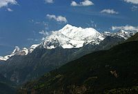
. With its 4506 m (14,783 ft) summit, it is one of the major peaks in the Alps
Alps
The Alps is one of the great mountain range systems of Europe, stretching from Austria and Slovenia in the east through Italy, Switzerland, Liechtenstein and Germany to France in the west....
and overtops the nearby Matterhorn
Matterhorn
The Matterhorn , Monte Cervino or Mont Cervin , is a mountain in the Pennine Alps on the border between Switzerland and Italy. Its summit is 4,478 metres high, making it one of the highest peaks in the Alps. The four steep faces, rising above the surrounding glaciers, face the four compass points...
by some 30 metres. It was first climbed in 1861 from Randa by John Tyndall
John Tyndall
John Tyndall FRS was a prominent Irish 19th century physicist. His initial scientific fame arose in the 1850s from his study of diamagnetism. Later he studied thermal radiation, and produced a number of discoveries about processes in the atmosphere...
, accompanied by the guides J.J. Bennen and Ulrich Wenger.
In April and May of 1991, two consecutive rockslides
Randa rockslides
In April and May 1991, two consecutive rockslides occurred from a cliff above the town of Randa in the Matter valley of Switzerland. The rockslides released a cumulative volume of approximately 30 million cubic meters of debris, with each of the rockslide stages occurring over several hours...
took place from a cliff above the town of Randa on the east side of the massif.
Geography
The Weisshorn is situated in the Swiss canton of ValaisValais
The Valais is one of the 26 cantons of Switzerland in the southwestern part of the country, around the valley of the Rhône from its headwaters to Lake Geneva, separating the Pennine Alps from the Bernese Alps. The canton is one of the drier parts of Switzerland in its central Rhône valley...
, about 25 km southwards from the Rhone
Rhône
Rhone can refer to:* Rhone, one of the major rivers of Europe, running through Switzerland and France* Rhône Glacier, the source of the Rhone River and one of the primary contributors to Lake Geneva in the far eastern end of the canton of Valais in Switzerland...
, on a north-south orientated chain separating the Val d'Anniviers
Val d'Anniviers
The val d'Anniviers is a Swiss alpine valley, situated in the district of Sierre in Valais, which extends south of the Rhône Valley. The valley was home to six municipalities: Ayer, Chandolin, Grimentz, Saint-Jean, Saint-Luc, Vissoie, Vercorin and Zinal. The citizens of those municipalities agreed...
to the west and the Mattertal
Mattertal
The Matter Valley is located in southwestern Switzerland, south of the Rhone valley in the canton of Valais. The village of Zermatt is the most important settlement of the valley, which is surrounded by many four-thousanders, including the Matterhorn.-Geography:Located in the Pennine Alps, the...
to the east. After the Dom, the Weisshorn is the second-highest Alpine summit situated completely out the main chain
Main chain of the Alps
The Alpine divide is the central line of mountains that forms the water divide of the range. Main chains of mountain ranges are traditionally designated in this way, and generally include the highest peaks of a range; the Alps are something of an unusual case in that several significant groups of...
and on both sides the water end up in the Rhone. The Weisshorn is only one of the many peaks surrounding the region of Zermatt
Zermatt
Zermatt is a municipality in the district of Visp in the German-speaking section of the canton of Valais in Switzerland. It has a population of about 5,800 inhabitants....
, along with the Dent Blanche
Dent Blanche
The Dent Blanche is a mountain in the Pennine Alps, lying in the canton of Valais in Switzerland. With its high summit, it is one of the highest peaks in the Alps.-Naming:...
, the Dent d'Hérens
Dent d'Hérens
The Dent d'Hérens is a mountain in the Pennine Alps, lying on the border between Italy and Switzerland. The mountain lies a few kilometres west of the Matterhorn.The Aosta hut is used for the normal route.-Naming:...
, the Matterhorn
Matterhorn
The Matterhorn , Monte Cervino or Mont Cervin , is a mountain in the Pennine Alps on the border between Switzerland and Italy. Its summit is 4,478 metres high, making it one of the highest peaks in the Alps. The four steep faces, rising above the surrounding glaciers, face the four compass points...
and Monte Rosa
Monte Rosa
The Monte Rosa Massif is a mountain massif located in the eastern part of the Pennine Alps. It is located between Switzerland and Italy...
.
Moming Glacier
The Moming Glacier is a 3 km long glacier situated in the Pennine Alps in the canton of Valais in Switzerland. In 1973 it had an area of 6.39 km².-External links:*...
. The northern spur forks out at a considerable distance below the summit into two branches enclosing the Turtmann Glacier
Turtmann Glacier
The Turtmann Glacier is a 5 km long glacier situated in the Pennine Alps in the canton of Valais in Switzerland. In 1973 it had an area of 5.91 km². The glacier is located north of Bishorn and Weisshorn....
. The eastern branch connects the mountain with the Bishorn
Bishorn
The Bishorn is a mountain in the Pennine Alps in Switzerland, just north of the Weisshorn.The mountain has two distinct summits, separated by a 600-metre easy-angled snow ridge....
(4,153 m).
Geology
The Weisshorn is the culminating point of the Dent Blanche nappe, a klippeKlippe
thumb|right|350px|Schematic overview of a thrust system. The shaded material is called a [[nappe]]. The erosional hole is called a [[window |window or fenster]]. The klippe is the isolated block of the nappe overlying autochthonous material....
belonging to the Austroalpine nappes
Austroalpine nappes
The Austroalpine nappes are a geological nappe stack in the European Alps. The Alps contain three such stacks, of which the Austroalpine nappes are structurally on top of the other two...
. The mountain is composed of gneiss
Gneiss
Gneiss is a common and widely distributed type of rock formed by high-grade regional metamorphic processes from pre-existing formations that were originally either igneous or sedimentary rocks.-Etymology:...
es; the west face is also composed of sedimentary rocks from the cretaceous
Cretaceous
The Cretaceous , derived from the Latin "creta" , usually abbreviated K for its German translation Kreide , is a geologic period and system from circa to million years ago. In the geologic timescale, the Cretaceous follows the Jurassic period and is followed by the Paleogene period of the...
period.
Climbing history
The mountain was first climbed on 19 August 1861 by the 29-year-old physicist John TyndallJohn Tyndall
John Tyndall FRS was a prominent Irish 19th century physicist. His initial scientific fame arose in the 1850s from his study of diamagnetism. Later he studied thermal radiation, and produced a number of discoveries about processes in the atmosphere...
, with guides J. J. Bennen and Ulrich Wenger. Their itinerary corresponds to the normal route for climbing the mountain today: the east ridge, starting from the Weisshorn hut. Helmut Dumler,Willi P. Burkhardt, Les 4000 des Alpes, ISBN 2-7003-1305-4
1860 attempt
Melchior Anderegg
Melchior Anderegg , from Zaun, Meiringen, was a Swiss mountain guide and the first ascensionist of many prominent mountains in the western Alps during the golden and silver ages of alpinism...
, and engaged Johann Kronig as second guide. They slept at the huts of Schallenbergalp and started at half-past one on the morning of the 1st July. Crossing the moraine, they walked until they reached a steep and rugged portion of the glacier, which hid the mountain from their view; and rounding this obstruction with some difficulty, they reached the upper portion of the glacier about five o'clock. They saw that the ridges were thickly coated over with fresh snow, and, except a little patch of rock some 700 or 800 feet (243.8 m) below the summit, the whole mass was of brilliant and dazzling whiteness. They decided to try the southern side which seemed less steep and more practicable to Melchior but an avalanche stopped them:
- "For six mortal hours we toiled up the steep face of the mountain...A great many steps had to be cut, but for the most part we were able to tread out our foot-holds in the snow. About half-past nine the difficulties became much greater - ten or twelve inches of snow rested upon the ice. We could get not safe footing upon it, and my clinometer indicated an angle of 48 or 49 degrees. The necessity of clearing away the snow before the step could be cut in the ice beneath it, made Melchior's work very arduous, and the higher we got the greater the difficulties became. We had to take off veil and spectacles, and use all our eyes, the footholds were so insecure, and this, though the sun was extremely hot and there was not a cloud to be seen. Suddenly the heat of the sun loosened some snow just above us, and down came a little avalanche quite near enough to be exceedingly unpleasant.
The guide Kronig asked Mathews to give up the expedition. They turned back and reached Zermatt in the evening, after nineteen hours of walking. They experienced other avalanches on the descent and the eyes of Mathews were severely burnt.
First ascent
Accompanied by the guides J.J. Bennen, of Laax, and Ulrich Wenger, of Grindelwald, John TyndallJohn Tyndall
John Tyndall FRS was a prominent Irish 19th century physicist. His initial scientific fame arose in the 1850s from his study of diamagnetism. Later he studied thermal radiation, and produced a number of discoveries about processes in the atmosphere...
started the ascent from Randa at 1.00 p.m. on 18 August, 1861. They had a bivouac and resumed the climb at 3.35 a.m. on the next day. Tyndall was optimistic but the ascent became difficult, he wrote:
- "Sometimes it was a fair pull upwards, sometimes an oblique twist round the corner of a rock tower; sometimes it was the grip of the finger ends in a fissure and lateral shifting of the whole body in a line parallel to the crack. Many times I found myself with my feet highest and my head lowest."
They reached a dangerous thin ridge of snow, little wider than a hand's breadth, with precipices on either side. The guide Bennen trod the snow down and saw that is was firm enough to cross. Tyndall and Wenger followed Bennen, but yet the summit seemed less attainable and they were all tired. However Tyndall steeled himself with patriotic thoughts:
- "I thought of Englishmen in battle, of the qualities which had made them famous: it was mainly the quality of not knowing when to yield - of fighting for duty even after they had ceased to be animated by hope. Such thoughts helped to lift me over the rocks."
After four hours of struggle they reached a sharp ridge of snow and finally arrived to the summit. The return was found to be not much less difficult than the ascent; and they regained Randa at 11 p.m., after about 20 hours of almost constant hard work.
Other ascents
The second ascent, in 1862, was made by Leslie StephenLeslie Stephen
Sir Leslie Stephen, KCB was an English author, critic and mountaineer, and the father of Virginia Woolf and Vanessa Bell.-Life:...
. Starting with Melchior Anderegg and Franz Biener, of Zermatt. It was from a chalet below the Schallenberg Alp, nearly 2 hours lower than Tyndall's bivouac, that Stephen gained the highest point in 9.5 hours, and returned to Randa in 7.5 hours more, reaching Zermatt the same evening.
In 1877, another route was opened by W. E. Davidson, J. W. Hartley and H. S. Hoare, with guides P. Rubi, J. Juan and A. Pollinger. After climbing part of the lower south-east face above the Schali Glacier, they reached the Schaligrat (south-west ridge) and continued to the summit. The complete ridge (which was considered too difficult and dangerous in its lower part) was first climbed in 1895 by J. M. Biner, A. Imboden and E. Broome. The south-east face was completely climbed in 1906 by Geoffrey Winthrop Young
Geoffrey Winthrop Young
Geoffrey Winthrop Young D.Litt. was a British climber, poet and educator, and author of several notable books on mountaineering.-Mountaineering:...
, V. J. Ryan, Lochmatter and P. Knubel.
The glaciated north-east face was first climbed in 1871 by J. H. Kitson with guides Christian Almer
Christian Almer
thumb|220px|Christian AlmerChristian Almer was a Swiss mountain guide and the first ascentionist of many prominent mountains in the western Alps during the golden and silver ages of alpinism....
and his son. Almer wanted to reach the summit by nine o'clock in the morning while Kitson's wife watched them from the Gornergrat
Gornergrat
The Gornergrat is a ridge of the Pennine Alps, Switzerland, overlooking the Gorner Glacier to the south. It can be reached by the Gornergratbahn rack railway from Zermatt...
. In fact the difficulties were more serious than expected and they didn't reach the summit before midday. Shortly after, the ascent was repeated by W. A. B. Coolidge
W. A. B. Coolidge
William Augustus Brevoort Coolidge was an American historian, theologian and mountaineer.Coolidge was born in New York as the son of Frederic William Skinner Coolidge, a Boston merchant, and Elisabeth Neville Brevoort of the Netherlands. He studied history and law at St...
and Meta Brevoort
Meta Brevoort
Marguerite "Meta" Brevoort , an American mountain climber, spent her early years in a Paris convent school. She made a number of important ascents in the Alps in the 1860s and 1870s, but was thwarted in her two greatest alpine ambitions: to be the first woman to climb the Matterhorn, and the first...
. Both expeditions climbed the part of the face below the Grand Gendarme and continued near the north ridge. In 1909 G. W. Young and J. Knubel climbed the face by the central spur.
The west face was first climbed in 1879 by G. A. Passingham with guides F. Imseng and L. Zurbrücken. Other routes on the face were opened in 1883 and 1889. The easiest passage on the east face was found in 1890 by G. W. Young, who climbed the spur under the Grand Gendarme with L. and B. Theytaz by a route known as the Younggrat.
Grand Gendarme
The Grand Gendarme is a minor summit on the Weisshorn north ridge in the Pennine Alps. Because of its small prominence it was included in the enlarged list of alpine four-thousanders.- External links :*...
on the unexplored north ridge was first reached in 1898. One month later, on 21 September 1898, H. Biehly and H. Burgener made the first complete traverse on the north ridge to the summit from the Bishorn.
In 1888 George Winkler was killed in a fall on the west face. He left Zinal
Zinal
Zinal is a village located in the municipality of Anniviers in the canton of Valais in Switzerland. It lies at an altitude of 1,675 metres in the Swiss Alps in the Val d'Anniviers, a valley running from the Zinal Glacier, north of Dent Blanche to the village of Ayer...
alone on 17 August, without telling others his precise route. The rescue team only found a photo and a hat near an avalanche cone. His body was not found until the summer of 1956, on the Weisshorn Glacier. John Garforth Cockin was also killed making a solo attempt on the south-east face twelve years later.
In 1925 Eleonore Noll-Hasenclever, H. Pfann and H. Trier were caught in an avalanche on the north-east face when they tried to reach the east ridge after interrupting their ascent on the north ridge on account of adverse weather conditions. Pfann and Trier survived, but Hasenclever died from asphyxiation.
1983 helicopter crash
An Alouette IIIAérospatiale Alouette III
The Aérospatiale Alouette III is a single-engine, light utility helicopter developed by Sud Aviation. It was manufactured by Aérospatiale of France, and under licence by Hindustan Aeronautics Limited in India as Hal Chetak and Industria Aeronautică Română in Romania.The Alouette III is the...
helicopter
Helicopter
A helicopter is a type of rotorcraft in which lift and thrust are supplied by one or more engine-driven rotors. This allows the helicopter to take off and land vertically, to hover, and to fly forwards, backwards, and laterally...
from Air Zermatt crashed on a night flight on the Schali Glacier (south of the peak) on 31 July 1983. The helicopter was carrying the pilot, his assistant and a mountain guide who was searching for two missing alpinists. A false alarm made the pilot try to land the helicopter on the glacier at 3,160 m. All the crew were severely injured but the guide and pilot survived. The two missing alpinists were later found dead.
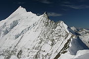
Climbing routes
All the routes are difficult. The normal route starts from the Weisshorn hut on the east side and goes along the sharp east ridge.The Weisshorn can be climbed from the Bishorn
Bishorn
The Bishorn is a mountain in the Pennine Alps in Switzerland, just north of the Weisshorn.The mountain has two distinct summits, separated by a 600-metre easy-angled snow ridge....
via the north ridge, departing from the Cabane de Tracuit, above Zinal
Zinal
Zinal is a village located in the municipality of Anniviers in the canton of Valais in Switzerland. It lies at an altitude of 1,675 metres in the Swiss Alps in the Val d'Anniviers, a valley running from the Zinal Glacier, north of Dent Blanche to the village of Ayer...
. The first three hours consist of relatively easy walking across the glacier and lead to the summit of the Bishorn (4153 m). The second part of the ascent is very exposed and takes another five hours, during which the Grand Gendarme
Grand Gendarme
The Grand Gendarme is a minor summit on the Weisshorn north ridge in the Pennine Alps. Because of its small prominence it was included in the enlarged list of alpine four-thousanders.- External links :*...
must be climbed.