
Pennine Alps
Encyclopedia
- Not to be confused with the PenninesPenninesThe Pennines are a low-rising mountain range, separating the North West of England from Yorkshire and the North East.Often described as the "backbone of England", they form a more-or-less continuous range stretching from the Peak District in Derbyshire, around the northern and eastern edges of...
.
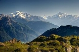
The Pennine Alps (also: Valais Alps) are a mountain range
Mountain range
A mountain range is a single, large mass consisting of a succession of mountains or narrowly spaced mountain ridges, with or without peaks, closely related in position, direction, formation, and age; a component part of a mountain system or of a mountain chain...
in the western part of the Alps
Alps
The Alps is one of the great mountain range systems of Europe, stretching from Austria and Slovenia in the east through Italy, Switzerland, Liechtenstein and Germany to France in the west....
. They are located in Switzerland
Switzerland
Switzerland name of one of the Swiss cantons. ; ; ; or ), in its full name the Swiss Confederation , is a federal republic consisting of 26 cantons, with Bern as the seat of the federal authorities. The country is situated in Western Europe,Or Central Europe depending on the definition....
(Valais
Valais
The Valais is one of the 26 cantons of Switzerland in the southwestern part of the country, around the valley of the Rhône from its headwaters to Lake Geneva, separating the Pennine Alps from the Bernese Alps. The canton is one of the drier parts of Switzerland in its central Rhône valley...
) and Italy
Italy
Italy , officially the Italian Republic languages]] under the European Charter for Regional or Minority Languages. In each of these, Italy's official name is as follows:;;;;;;;;), is a unitary parliamentary republic in South-Central Europe. To the north it borders France, Switzerland, Austria and...
(Piedmont
Piedmont
Piedmont is one of the 20 regions of Italy. It has an area of 25,402 square kilometres and a population of about 4.4 million. The capital of Piedmont is Turin. The main local language is Piedmontese. Occitan is also spoken by a minority in the Occitan Valleys situated in the Provinces of...
and the Aosta Valley). The Col Ferret
Col Ferret
The Col Ferret is an Alpine pass between the canton of Valais and the Aosta Valley. This pass separates the Mont Blanc Massif from the Pennine Alps.-See also:* List of highest paved roads in Europe...
separates them from the Mont Blanc Massif
Mont Blanc Massif
The Mont Blanc massif is a mountain range in the western Alps. It is named after Mont Blanc, at 4,810.45 m the highest summit of the Alps. It is located in France , Italy , and Switzerland...
; the Dora Baltea
Dora Baltea
Dora Baltea or Doire Baltée , is a river in northern Italy. It is a left-hand tributary of the Po River, and is about 160 km long...
valley separates them from the Graian Alps
Graian Alps
The Graian Alps are a mountain range in the western part of the Alps. They are located in France , Italy , and Switzerland...
; the Simplon Pass
Simplon Pass
Simplon Pass is a high mountain pass between the Pennine Alps and the Lepontine Alps in Switzerland. It connects Brig in the canton of Valais with Domodossola in Piedmont . The pass itself and the villages on each side of it, such as Gondo, are in Switzerland...
separates them from the Lepontine Alps
Lepontine Alps
The Lepontine Alps are a mountain range in the central part of the Alps. They are located in Switzerland and Italy .On the north the upper Rhône valley separate them from the Bernese Alps and the Furka Pass and the upper Reuss valley separates them from the Urner Alps; on the west the Simplon Pass...
; the Rhône
Rhône River
The Rhone is one of the major rivers of Europe, rising in Switzerland and running from there through southeastern France. At Arles, near its mouth on the Mediterranean Sea, the river divides into two branches, known as the Great Rhone and the Little Rhone...
valley separates them from the Bernese Alps
Bernese Alps
The Bernese Alps are a group of mountain ranges in the western part of the Alps, in Switzerland. Although the name suggests that they are located in the Bernese Oberland region of the canton of Bern, portions of the Bernese Alps are in the adjacent cantons of Valais, Lucerne, Obwalden, Fribourg and...
.
The Italian side is drained by the rivers Dora Baltea
Dora Baltea
Dora Baltea or Doire Baltée , is a river in northern Italy. It is a left-hand tributary of the Po River, and is about 160 km long...
, Sesia
Sesia River
The Sesia is a river in north-western Italy, tributary to the Po. Its sources are the glaciers of Monte Rosa at the border with Switzerland. It flows through the Alpine valley Valsesia and the towns Varallo Sesia, Quarona, Borgosesia and Vercelli...
and Toce
Toce
The Toce is a river in Piedmont, Italy, which stretches the length of the Val d'Ossola from the Swiss border to Lake Maggiore into which it debouches near Fondotoce in the Commune of Verbania. The river is c. 76 kilometres in length and is formed in the upper Val Formazza by the confluence of a...
, tributaries of the Po
Po River
The Po |Ligurian]]: Bodincus or Bodencus) is a river that flows either or – considering the length of the Maira, a right bank tributary – eastward across northern Italy, from a spring seeping from a stony hillside at Pian del Re, a flat place at the head of the Val Po under the northwest face...
. The Swiss side is drained by the Rhône River
Rhône River
The Rhone is one of the major rivers of Europe, rising in Switzerland and running from there through southeastern France. At Arles, near its mouth on the Mediterranean Sea, the river divides into two branches, known as the Great Rhone and the Little Rhone...
.
The Great St Bernard Tunnel
Great St Bernard Tunnel
The Great St Bernard Tunnel is a road tunnel complementing the Great St Bernard Pass, linking Martigny with Saint-Rhémy-en-Bosses ....
, under the Great St Bernard Pass, leads from Martigny, Switzerland
Martigny, Switzerland
Martigny is the capital of the French-speaking district of Martigny in the canton of Valais in Switzerland. It lies at an elevation of , and its population is approximately 15000 inhabitants . It is a junction of roads joining Italy, France and Switzerland...
to Aosta
Aosta
Aosta is the principal city of the bilingual Aosta Valley in the Italian Alps, north-northwest of Turin. It is situated near the Italian entrance of the Mont Blanc Tunnel, at the confluence of the Buthier and the Dora Baltea, and at the junction of the Great and Little St. Bernard routes...
.
Morphology
The main chain (watershed between the Mediterranean SeaMediterranean Sea
The Mediterranean Sea is a sea connected to the Atlantic Ocean surrounded by the Mediterranean region and almost completely enclosed by land: on the north by Anatolia and Europe, on the south by North Africa, and on the east by the Levant...
and Adriatic Sea
Adriatic Sea
The Adriatic Sea is a body of water separating the Italian Peninsula from the Balkan peninsula, and the system of the Apennine Mountains from that of the Dinaric Alps and adjacent ranges...
) runs from west to east on the border between Italy
Italy
Italy , officially the Italian Republic languages]] under the European Charter for Regional or Minority Languages. In each of these, Italy's official name is as follows:;;;;;;;;), is a unitary parliamentary republic in South-Central Europe. To the north it borders France, Switzerland, Austria and...
(south) and Switzerland
Switzerland
Switzerland name of one of the Swiss cantons. ; ; ; or ), in its full name the Swiss Confederation , is a federal republic consisting of 26 cantons, with Bern as the seat of the federal authorities. The country is situated in Western Europe,Or Central Europe depending on the definition....
(north). From Mont Vélan
Mont Vélan
Mont Vélan is a mountain in the Pennine Alps, located on the border between Switzerland and Italy. At 3,727, metres Mont Vélan is the highest summit lying between the Great St Bernard Pass and Grand Combin. Two large glaciers cover its northern flanks: Glacier de Tseudet and Glacier de Valsoray...
, the first high summit east of St Bernard Pass
Great St. Bernard Pass
Great St. Bernard Pass is the third highest road pass in Switzerland. It connects Martigny in the Canton of Valais in Switzerland to Aosta in Italy. It is the lowest pass lying on the ridge between the two highest summits of the Alps, Mont Blanc and Monte Rosa...
, the chain rarely goes below 3000 metres and contains many four-thousanders such as Matterhorn
Matterhorn
The Matterhorn , Monte Cervino or Mont Cervin , is a mountain in the Pennine Alps on the border between Switzerland and Italy. Its summit is 4,478 metres high, making it one of the highest peaks in the Alps. The four steep faces, rising above the surrounding glaciers, face the four compass points...
or Monte Rosa
Monte Rosa
The Monte Rosa Massif is a mountain massif located in the eastern part of the Pennine Alps. It is located between Switzerland and Italy...
. The valleys are quite similar on both side of the border, being generally oriented perpendicular to the main chain and descending progressively into the Rhône
Rhône
Rhone can refer to:* Rhone, one of the major rivers of Europe, running through Switzerland and France* Rhône Glacier, the source of the Rhone River and one of the primary contributors to Lake Geneva in the far eastern end of the canton of Valais in Switzerland...
Valley on the north and the Aosta Valley on the south. Unlike many other mountain ranges, the higher peaks are often located outside the main chain and found themselves between the northern valleys (Grand Combin
Grand Combin
The Grand Combin is a mountain in the western Pennine Alps in Switzerland. With its high summit it is one of the highest peaks in the Alps and the second most prominent of its range...
, Weisshorn
Weisshorn
The Weisshorn is a mountain in the Pennine Alps, in Switzerland. With its summit, it is one of the major peaks in the Alps and overtops the nearby Matterhorn by some 30 metres. It was first climbed in 1861 from Randa by John Tyndall, accompanied by the guides J.J...
, Mischabel, Weissmies
Weissmies
The Weissmies is a mountain in the Pennine Alps in the canton of Valais in Switzerland near the village of Saas-Fee. It is the easternmost four-thousander of its range.- Geography :...
).
Peaks
The chief peaks of the Pennine Alps are:Glaciers
Main glacierGlacier
A glacier is a large persistent body of ice that forms where the accumulation of snow exceeds its ablation over many years, often centuries. At least 0.1 km² in area and 50 m thick, but often much larger, a glacier slowly deforms and flows due to stresses induced by its weight...
s:
- Gorner Glacier
- Corbassière GlacierCorbassière GlacierThe Corbassière Glacier is a valley glacier in the Grand Combin massif in the Pennine Alps in southwestern Valais. It is long with an average width of slightly more than and covers an area of ....
- Findel GlacierFindel GlacierThe Findel Glacier is a valley glacier in the Monte Rosa massif east of Zermatt in the Pennine Alps. It has a length of and covers an area of ....
- Zmutt GlacierZmutt GlacierThe Zmutt Glacier is a long glacier situated in the Pennine Alps in the canton of Valais in Switzerland. In 1973 it had an area of .-External links:*...
- Zinal GlacierZinal GlacierThe Zinal Glacier is a long glacier situated in the Pennine Alps in the canton of Valais in Switzerland. In 1973 it had an area of . The glacier gives birth to the Navissence River, which runs through a cave.-External links:*...
- Otemma GlacierOtemma GlacierThe Otemma Glacier is a long glacier situated in the Pennine Alps in the canton of Valais in Switzerland. In 1973 it had an area of .-External links:*...
- Allalin GlacierAllalin GlacierThe Allalin Glacier is a long glacier situated in the Pennine Alps near the Allalinhorn in the canton of Valais in Switzerland. In 1973 it had an area of . The glacier is bordered on the west by the Allalinhorn, Rimpfischhorn and Strahlhorn. It is not to be confused with the Fee Glacier which...
- Ferpècle GlacierFerpècle GlacierThe Ferpècle Glacier is a long glacier situated in the Pennine Alps in the canton of Valais in Switzerland. In 1973 it had an area of .-External links:*...
- Fee GlacierFee GlacierThe Fee Glacier is a long glacier situated in the Pennine Alps in the canton of Valais in Switzerland. In 1973 it had a length of and an area of . It lies east of the Mischabel range, between the summit of Dom on the north and Allalinhorn on the south.The glacier is easily accessible via the...
- Mont Miné GlacierMont Miné GlacierThe Mont Miné Glacier is a long glacier situated in the Pennine Alps in the canton of Valais in Switzerland. In 1973 it had an area of .-External links:*...
- Ried GlacierRied GlacierThe Ried Glacier is a 6 km long glacier situated in the Pennine Alps in the canton of Valais in Switzerland. In 1973 it had an area of 8.22 km².The glacier lies in the Mischabel range, at the foot of Nadelhorn and not far from Dom.-External links:*...
- Turtmann GlacierTurtmann GlacierThe Turtmann Glacier is a 5 km long glacier situated in the Pennine Alps in the canton of Valais in Switzerland. In 1973 it had an area of 5.91 km². The glacier is located north of Bishorn and Weisshorn....
- Moiry GlacierMoiry GlacierThe Moiry Glacier is a 5 km long glacier situated in the Pennine Alps in the canton of Valais in Switzerland. In 1973 it had an area of 5.75 km².-External links:*...
- Arolla GlacierArolla GlacierThe Arolla Glacier is a long glacier situated in the Pennine Alps in the canton of Valais in Switzerland. In 1973 it had an area of ....
- Moming GlacierMoming GlacierThe Moming Glacier is a 3 km long glacier situated in the Pennine Alps in the canton of Valais in Switzerland. In 1973 it had an area of 6.39 km².-External links:*...
- Cheilon GlacierCheilon GlacierThe Cheilon Glacier is a 3 km long glacier situated in the Pennine Alps in the canton of Valais in Switzerland. In 1973 it had an area of 4.56 km².-External links:*...
Passes
The chief passesMountain pass
A mountain pass is a route through a mountain range or over a ridge. If following the lowest possible route, a pass is locally the highest point on that route...
of the Pennine Alps are:
| Mountain pass | location | type | elevation | |
|---|---|---|---|---|
| Sesiajoch | Zermatt Zermatt Zermatt is a municipality in the district of Visp in the German-speaking section of the canton of Valais in Switzerland. It has a population of about 5,800 inhabitants.... to Alagna Alagna Alagna is a comune in the Province of Pavia in the Italian region Lombardy, located about 40 km southwest of Milan and about 20 km west of Pavia. As of 31 December 2004, it had a population of 876 and an area of 8.6 km².... |
snow | 4,424 | 14,515 |
| Domjoch | Randa to Saas-Fee Saas-Fee Saas-Fee is the main village in the Saastal, or the Saas Valley, and is a municipality in the district of Visp in the canton of Valais in Switzerland... |
snow | 4,286 | 14,062 |
| Lysjoch | Zermatt to Gressoney-La-Trinité Gressoney-La-Trinité Gressoney-La-Trinité is a town and comune in the Aosta Valley region of north-western Italy.-Geography:... |
snow | 4,277 | 14,033 |
| Mischabeljoch | Zermatt to Saas-Fee | snow | 3,856 | 12,651 |
| Alphubel Pass | Zermatt to Saas-Fee | snow | 3,802 | 12,474 |
| Adler Pass | Zermatt to Saas-Fee | snow | 3,798 | 12,461 |
| Moming Pass | Zermatt to Zinal Zinal Zinal is a village located in the municipality of Anniviers in the canton of Valais in Switzerland. It lies at an altitude of 1,675 metres in the Swiss Alps in the Val d'Anniviers, a valley running from the Zinal Glacier, north of Dent Blanche to the village of Ayer... |
snow | 3,745 | 12,287 |
| Schwarztor | Zermatt to Ayas Ayas, Italy Ayas is a comune in the Aosta Valley region of north-western Italy.- Geography :It is made up of several frazioni , the two major ones being Antagnod which holds the town hall and the main parish, and Champoluc... |
snow | 3,741 | 12,274 |
| Ried Pass | Sankt-Niklaus to Saas-Fee | snow | 3,597 | 11,800 |
| Neues Weisstor | Zermatt to Macugnaga Macugnaga Macugnaga is a mountain village at 1327 m altitude, in the province of Verbano-Cusio-Ossola, in the north of Piedmont region .It is placed at the base of Dufourspitze 4638 m, the second tallest peak in Europe, in the Monte Rosa Massif, along Anzasca valley, one of the seven valleys around the... |
snow | 3,580 | 11,746 |
| Allalin Pass | Zermatt to Saas-Fee | snow | 3,570 | 11,713 |
| Col de Valpelline | Zermatt to Aosta Aosta Aosta is the principal city of the bilingual Aosta Valley in the Italian Alps, north-northwest of Turin. It is situated near the Italian entrance of the Mont Blanc Tunnel, at the confluence of the Buthier and the Dora Baltea, and at the junction of the Great and Little St. Bernard routes... |
snow | 3,562 | 11,687 |
| Biesjoch | Randa to Turtmann Turtmann Turtmann is a municipality in the district of Leuk in the canton of Valais in Switzerland.-History:Turtmann is first mentioned in 1050 as Curtmannonis. In 1210 it was mentioned as Torthemanei and Tortemagny.... |
snow | 3,549 | 11,644 |
| Triftjoch | Zermatt to Zinal | snow | 3,540 | 11,615 |
| Col du Sonadon | Bourg-Saint-Pierre Bourg-Saint-Pierre Bourg-Saint-Pierre is a municipality in the district of Entremont in the canton of Valais in Switzerland.-Geography:... to the Val de Bagnes Bagnes Bagnes is a municipality in the district of Entremont in the canton of Valais in Switzerland.With an area of , Bagnes used to be the largest municipality of Switzerland until the formation of Glarus Süd in 2011.-History:... |
snow | 3,489 | 11,447 |
| Col d'Herens | Zermatt to Evolène Evolène Evolène is a municipality in the district of Hérens in the canton of Valais in Switzerland.-History:Evolène is first mentioned in 1250 as Ewelina. In 1444 it was mentioned as in loco de Evolena.- Avalanches of the 21st of February, 1999 :... |
snow | 3,480 | 11,418 |
| Col Durand | Zermatt to Zinal | snow | 3,474 | 11,398 |
| Col des Maisons Blanches | Bourg-Saint-Pierre to the Val de Bagnes | snow | 3,426 | 11,241 |
| Col de Bertol | Arolla Arolla Arolla is a village in the municipality of Evolène in the canton of Valais in Switzerland.It is situated at the end of the Val d'Hérens south of Sion at 1998m altitude in the Pennine Alps... to the Col d'Herens |
snow | 3,414 | 11,200 |
| Col du Mont Rouge | Val de Bagnes to the Val d'Hérémence Hérémence Hérémence is a municipality in the district of Hérens in the canton of Valais in Switzerland.-Geography:Hérémence has an area, , of . Of this area, 18.0% is used for agricultural purposes, while 18.8% is forested... |
snow | 3,341 | 10,962 |
| Theodulpass | Zermatt to Valtournenche Valtournenche Valtournenche is a town and comune in the Aosta Valley region of north-western Italy.-Notable people:* Jean-Antoine Carrel , mountain climber* Jean-Joseph Maquignaz , mountain climber... |
snow | 3,322 | 10,899 |
| Col de Tracuit | Zinal to Turtmann | snow | 3,252 | 10,670 |
| Zwischbergen Pass | Saas-Fee to Gondo Zwischbergen Zwischbergen is a municipality in the district of Brig in the canton of Valais in Switzerland.-Gondo:The village of Gondo, which is part of Zwischenbergen, is located at the southern foot of the Simplon Pass on the Italian border. Although the majority language has been German for a long time, the... |
snow | 3,248 | 10,657 |
| Col d'Oren | Val de Bagnes to the Valpelline | snow | 3,242 | 10,637 |
| Col de Seilon | Val de Bagnes to the Val d'Hérémence | snow | 3,200 | 10,499 |
| Col du Cret | Val de Bagnes to the Val d'Hérémence | snow | 3,148 | 10,329 |
| Col de Valcournera | Valtournenche to the Valpelline | snow | 3,147 | 10,325 |
| Col de Collon | Arolla to Aosta | snow | 3,130 | 10,270 |
| Col de Valsorey | Bourg-Saint-Pierre to Aosta | snow | 3,113 | 10'214 |
| Col de Chermontane | Val de Bagnes to Arolla | snow | 3084 | 10,119 |
| Cimes Blanches | Valtournenche to Ayas | bridle path | 2,980 | 9,777 |
| Col de Torrent | Evolène to the Val de Torrent | bridle path | 2,924 | 9,593 |
| Augstbord Pass | Sankt-Niklaus to Turtmann | bridle path | 2,893 | 9,492 |
| Col de Crete Seche | Val de Bagnes to the Valpelline | snow | 2,888 | 9,475 |
| Col d'Olen | Alagna to Gressoney | bridle path | 2,871 | 9,420 |
| Monte Moro | Saas-Fee to Macugnaga | bridle path | 2,862 | 9,390 |
| Pas de Chevres | Arolla to the Val d'Hérémence | foot path | 2,851 | 9,354 |
| Antrona Pass | Saas-Fee to Antrona | bridle path | 2,844 | 9,331 |
| Col de Sorebois | Zinal to the Val de Torrent | bridle path | 2,825 | 9,269 |
| Col de Vessona | Valpelline to Nus Nus Nus is a town and comune in the Aosta Valley region of northern Italy.... |
foot path | 2,794 | 9,167 |
| Fenêtre de Durand | Val de Bagnes to Aosta | bridle path | 2,786 | 9,141 |
| Z'Meiden Pass | Zinal to Turtmann | bridle path | 2,772 | 9,095 |
| Turlo Pass | Alagna to Macugnaga | foot path | 2,736 | 8,977 |
| Fenêtre de Ferret | Great St Bernard Great St. Bernard Pass Great St. Bernard Pass is the third highest road pass in Switzerland. It connects Martigny in the Canton of Valais in Switzerland to Aosta in Italy. It is the lowest pass lying on the ridge between the two highest summits of the Alps, Mont Blanc and Monte Rosa... to the Swiss Val Ferret |
bridle path | 2,699 | 8,855 |
| Colle Bettaforca | Ayas to Gressoney | bridle path | 2,676 | 8,780 |
| Col Serena | Great St Bernard to Morgex Morgex Morgex is a town and comune in the Aosta Valley region of north-western Italy.... |
foot path | 2,538 | 8,327 |
| Col Ferret | Courmayeur to Orsières | bridle path | 2,533 | 8,311 |
| Col de Valdobbia | Gressoney to the Val Sesia | bridle path | 2,479 | 8,134 |
| Great St Bernard Great St. Bernard Pass Great St. Bernard Pass is the third highest road pass in Switzerland. It connects Martigny in the Canton of Valais in Switzerland to Aosta in Italy. It is the lowest pass lying on the ridge between the two highest summits of the Alps, Mont Blanc and Monte Rosa... |
Martigny Martigny, Switzerland Martigny is the capital of the French-speaking district of Martigny in the canton of Valais in Switzerland. It lies at an elevation of , and its population is approximately 15000 inhabitants . It is a junction of roads joining Italy, France and Switzerland... to Aosta Aosta Aosta is the principal city of the bilingual Aosta Valley in the Italian Alps, north-northwest of Turin. It is situated near the Italian entrance of the Mont Blanc Tunnel, at the confluence of the Buthier and the Dora Baltea, and at the junction of the Great and Little St. Bernard routes... |
road | 2,472 | 8,111 |
| Col de Moud | Alagna to Rima Rima Rima, also known as Rima the Jungle Girl, is the fictional heroine of W. H. Hudson's 1904 novel Green Mansions: A Romance of the Tropical Forest. In 1974, she was adapted into a comic book character and featured in the short-lived monthly series Rima the Jungle Girl, published by DC Comics... |
bridle path | 2,323 | 7,622 |
| Col d'Egua | Rima to the Valle Anzasca | bridle path | 2,236 | 7,336 |
| Simplon Pass Simplon Pass Simplon Pass is a high mountain pass between the Pennine Alps and the Lepontine Alps in Switzerland. It connects Brig in the canton of Valais with Domodossola in Piedmont . The pass itself and the villages on each side of it, such as Gondo, are in Switzerland... |
Brig Brig, Switzerland Brig, officially Brig-Glis is a municipality in the district of Brig in the canton of Valais in Switzerland.The current municipality was formed in 1972 through the merger of Brig , Brigerbad and Glis.-History:... to Domodossola Domodossola Domodossola is a city and comune in the Province of Verbano-Cusio-Ossola, in the region of Piedmont, northern Italy... |
road | 2,009 | 6,592 |
| Baranca Pass | Varallo Varallo Varallo may refer to:*Varallo Sesia, an Italian comune in Province of Vercelli*Varallo Pombia, an Italian comune in province of Novara*Francisco Varallo , Argentine football forward player* Tanzio da Varallo... to the Val Anzasca |
bridle path | 1,820 | 5,971 |