
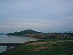
Tungabhadra River
Encyclopedia
The Tungabhadra River (kannada:ತುಂಗಭದ್ರಾ, Telugu
:తుంగభద్రా) is a sacred river in southern India that flows through the state of Karnataka
to Andhra Pradesh
, where it serves as the chief tributary
of the Krishna River
. In the epic Ramayana
, the Tungabhadra river was known by the name of Pampa
and the Bhadra River
, which flow down the eastern slope of the Western Ghats
in the state of Karnataka
. Along with Nethravathi (west flowing river, joining the Arabian Sea near Mangalore), the Thunga and the Bhadra rise at Gangamoola, in Varaha Parvatha in the Western Ghats forming parts of the Kuduremukh Iron Ore Project, at an elevation of 1198 metres. Bhadra river flows through the Industrial City Bhadravathi More than one hundred tributaries, streams, creeks, rivulets and the like contribute to each of these two rivers. The journey of Thunga and the Bhadra is 147 km (91.3 mi) and 171 km (106.3 mi) respectively, till they join at Kudali, at an elevation of about 610 metres near Holehonnur, about 15 km (9.3 mi) from Shimoga; areca granary of the country. It is a confluence of both the Dwaitha and the Adwaitha philosophies. From there, Thungabhadra meanders through the plains to a distance of 531 km (329.9 mi) and mingles with the Krishna at Gondimalla, near the famous Alampur in Mahaboobnagar District of Andhra Pradesh. Varada flowing through Shimoga, Uttara Kannada and Haveri Districts and Hagari in Chitradurga and Bellary Districts in Karnataka and Handri in Kurnool distriict of A.P. are the main tributaries of the Tungabhadra. Many rivulets and streams join these tributaries.
There are many holy places all along the rivers; primarily Temples of Saiva Cult on the banks of the Bhadra and all the cults on the banks of the Thunga. Sringeri, Sarada Petham established by the Adi Shnkarcaharya is the most famous one on the left bank of the Thunga, about 50 km (31.1 mi) downstream of its origin. Manthralayam Sree Raghavendra Swamy Muth in Kurnool District and Alampur in Mahaboobnagar Districit, known as Dakshina Kashi are the other important pilgrimage centres. There is a cluster of Nava Brahma temples constructed by the early Chalukyas. Jogulamba is the presiding deity of the place. Another important feature of the river banks is the flood protection walls all along the rivers, constructed by Sri Krishna Devaraya between 1525 and 1527 AD. You find them wherever there is a possibility of land erosion during the floods. It starts at Sringeri and ends at Kurnool; just few km from its mouth. They are of stone constructions and are still intact. Huge boulders of the size of 3' X 4' X 5' are also used in its construction.
It then takes a north-easterly direction through rugged ridges formed by boulders piled on ancient granite outcroppings over the elevated plateau that dominates peninsular India
, the Deccan Plateau
.
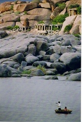
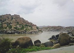 Piles of granite in varying shades of grey, ochre and pink dominate the landscape. The river has cut through weaker rocky substrata of the Hampi landscape and created a narrow gorge where granite hills confine the river in a deep ravine.
 In this setting the ruins of Vijayanagara
and Hampi
, the seat of power of the Vijayanagar empire, overlook this holy river, creating a mythological landscape merging sacred traditions about a multitude of significant divinities.
The granite outcrops slowly disappear as the river flows south and the land opens into a long, broad plain ending at the rising slopes of the Sandur hills, rich in iron and manganese
, beyond which is the town of Hosapete. A dam, the Tungabhadra Dam, was constructed at Hosapete in the middle of the 20th century to harness the river water, aiding the growth of agriculture and industry in the region.
The Tungabhadra River then flows east, joining the Krishna in Andhra Pradesh
state. From here the Krishna continues east to empty into the Bay of Bengal
. The wedge of land that lies north of the Tungabhadra River, between the Tungabhadra and the Krishna, is known as the Raichur Doab
.
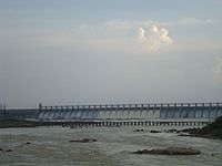 TungaBhadra dam is constructed across river Tungabhadra, a tributary of River Krishna. The dam is built near the town of Hosapete in Karnataka
. It is considered as a multipurpose dam or project. Its storage capacity is 135 Tmcft
. Owing to siltation the capacity has been reduced by about 30 Tmcft. If there is seasonal and late rains, the dam distributes the estimated quantity of 235 Tmcft. The dam is filled as when the water is let into the canals during the rainy season. The main architect of the dam was Thirumalai Iyengar, an engineer from Madras. As Tungabhadra Dam was constructed by him, so a general-purpose hall in this place was named after him. Multipurpose dams are the ones which help in generation of electricity
, irrigation
of land, prevention and control of floods etc. It has become a picnic
or tourist spot over the years. The dam is near to heritage
site Hampi
.
At Sunkesula, about 25 km upstream from Kurnool, a barrage was constructed at about 1860s by the British engineer, hailed as Bhagiratha for Andhras, Sir Arthur Cotton. Originally it was intended to be used for navigation also. As the road and rail transportation increased it is now an irrigation project, for Kurnool and Kadapa Districts, carrying water through the K.C. Canal.(Kurnool - Cuddapah canal - till recently Kadapa was spelled "Cuddapah"). Recently the barrage was replaced by the Kotla Vijayabhaskara Reddy Project, a permanent dam. It impounds about 15000000000 cubic foot (0.424752705 km³) of water and irrigates about 300000 acres (1,214.1 km²) of land in Kurnool and Kadapa districts.
s of litres of effluents were being released to the Tunga from [Shimoga] every year." This is the contribution of one city which, like Bhadrvathi and Hospet, cannot boast of being an industrial city. As such it is one of the most polluted rivers in the country.
Downriver from the industries, the water has turned dark brown and has a pungent odour. Altogether, the Tungabhadra River pollution has affected 1,000,000 people in the sub-basin as most villages used the river water, previously obtained through the ancient tank
system, for drinking, bathing, irrigating crops, fishing and livestock water. The livelihood of village fishermen has been harmed by regular fish kill
s that have exhausted Tungabhadra's fisheries.
One of the important rivers of Andhra Pradesh
Telugu language
Telugu is a Central Dravidian language primarily spoken in the state of Andhra Pradesh, India, where it is an official language. It is also spoken in the neighbouring states of Chattisgarh, Karnataka, Maharashtra, Orissa and Tamil Nadu...
:తుంగభద్రా) is a sacred river in southern India that flows through the state of Karnataka
Karnataka
Karnataka , the land of the Kannadigas, is a state in South West India. It was created on 1 November 1956, with the passing of the States Reorganisation Act and this day is annually celebrated as Karnataka Rajyotsava...
to Andhra Pradesh
Andhra Pradesh
Andhra Pradesh , is one of the 28 states of India, situated on the southeastern coast of India. It is India's fourth largest state by area and fifth largest by population. Its capital and largest city by population is Hyderabad.The total GDP of Andhra Pradesh is $100 billion and is ranked third...
, where it serves as the chief tributary
Tributary
A tributary or affluent is a stream or river that flows into a main stem river or a lake. A tributary does not flow directly into a sea or ocean...
of the Krishna River
Krishna River
The Krishna River , is one of the longest rivers in central-southern India, about . It is also referred to as Krishnaveni in its original nomenclature...
. In the epic Ramayana
Ramayana
The Ramayana is an ancient Sanskrit epic. It is ascribed to the Hindu sage Valmiki and forms an important part of the Hindu canon , considered to be itihāsa. The Ramayana is one of the two great epics of India and Nepal, the other being the Mahabharata...
, the Tungabhadra river was known by the name of Pampa
Course
The Tungabhadra River is formed by the confluence of two rivers, the Tunga RiverTunga River
The Tunga River is a river in Karnataka state, southern India. The river is born in the Western Ghats on a hill known as Varaha Parvata at a place called Gangamoola. From here, the river flows through two districts in Karnataka - Chikmagalur District and Shimoga District. It is 147 km long and...
and the Bhadra River
Bhadra River
The Bhadra River is a river in Karnataka state in southern India.The Bhadra originates at Gangamoola near Kudremukha, Western Ghats range, and flows east across the southern part of Deccan Plateau, joined by its tributaries the Somavahini near Hebbe, Thadabehalla, and Odirayanahalla. It flows...
, which flow down the eastern slope of the Western Ghats
Western Ghats
The Western Ghats, Western Ghauts or the Sahyādri is a mountain range along the western side of India. It runs north to south along the western edge of the Deccan Plateau, and separates the plateau from a narrow coastal plain along the Arabian Sea. The Western Ghats block rainfall to the Deccan...
in the state of Karnataka
Karnataka
Karnataka , the land of the Kannadigas, is a state in South West India. It was created on 1 November 1956, with the passing of the States Reorganisation Act and this day is annually celebrated as Karnataka Rajyotsava...
. Along with Nethravathi (west flowing river, joining the Arabian Sea near Mangalore), the Thunga and the Bhadra rise at Gangamoola, in Varaha Parvatha in the Western Ghats forming parts of the Kuduremukh Iron Ore Project, at an elevation of 1198 metres. Bhadra river flows through the Industrial City Bhadravathi More than one hundred tributaries, streams, creeks, rivulets and the like contribute to each of these two rivers. The journey of Thunga and the Bhadra is 147 km (91.3 mi) and 171 km (106.3 mi) respectively, till they join at Kudali, at an elevation of about 610 metres near Holehonnur, about 15 km (9.3 mi) from Shimoga; areca granary of the country. It is a confluence of both the Dwaitha and the Adwaitha philosophies. From there, Thungabhadra meanders through the plains to a distance of 531 km (329.9 mi) and mingles with the Krishna at Gondimalla, near the famous Alampur in Mahaboobnagar District of Andhra Pradesh. Varada flowing through Shimoga, Uttara Kannada and Haveri Districts and Hagari in Chitradurga and Bellary Districts in Karnataka and Handri in Kurnool distriict of A.P. are the main tributaries of the Tungabhadra. Many rivulets and streams join these tributaries.
There are many holy places all along the rivers; primarily Temples of Saiva Cult on the banks of the Bhadra and all the cults on the banks of the Thunga. Sringeri, Sarada Petham established by the Adi Shnkarcaharya is the most famous one on the left bank of the Thunga, about 50 km (31.1 mi) downstream of its origin. Manthralayam Sree Raghavendra Swamy Muth in Kurnool District and Alampur in Mahaboobnagar Districit, known as Dakshina Kashi are the other important pilgrimage centres. There is a cluster of Nava Brahma temples constructed by the early Chalukyas. Jogulamba is the presiding deity of the place. Another important feature of the river banks is the flood protection walls all along the rivers, constructed by Sri Krishna Devaraya between 1525 and 1527 AD. You find them wherever there is a possibility of land erosion during the floods. It starts at Sringeri and ends at Kurnool; just few km from its mouth. They are of stone constructions and are still intact. Huge boulders of the size of 3' X 4' X 5' are also used in its construction.
It then takes a north-easterly direction through rugged ridges formed by boulders piled on ancient granite outcroppings over the elevated plateau that dominates peninsular India
India
India , officially the Republic of India , is a country in South Asia. It is the seventh-largest country by geographical area, the second-most populous country with over 1.2 billion people, and the most populous democracy in the world...
, the Deccan Plateau
Deccan Plateau
The Deccan Plateau is a large plateau in India, making up the majority of the southern part of the country. It rises a hundred meters high in the north, rising further to more than a kilometers high in the south, forming a raised triangle nested within the familiar downward-pointing triangle of...
.
Vijayanagara
Vijayanagara is in Bellary District, northern Karnataka. It is the name of the now-ruined capital city "which was regarded as the second Rome" that surrounds modern-day Hampi, of the historic Vijayanagara empire which extended over the southern part of India....
and Hampi
Hampi
Hampi is a village in northern Karnataka state, India. It is located within the ruins of Vijayanagara, the former capital of the Vijayanagara Empire. Predating the city of Vijayanagara, it continues to be an important religious centre, housing the Virupaksha Temple, as well as several other...
, the seat of power of the Vijayanagar empire, overlook this holy river, creating a mythological landscape merging sacred traditions about a multitude of significant divinities.
The granite outcrops slowly disappear as the river flows south and the land opens into a long, broad plain ending at the rising slopes of the Sandur hills, rich in iron and manganese
Manganese
Manganese is a chemical element, designated by the symbol Mn. It has the atomic number 25. It is found as a free element in nature , and in many minerals...
, beyond which is the town of Hosapete. A dam, the Tungabhadra Dam, was constructed at Hosapete in the middle of the 20th century to harness the river water, aiding the growth of agriculture and industry in the region.
The Tungabhadra River then flows east, joining the Krishna in Andhra Pradesh
Andhra Pradesh
Andhra Pradesh , is one of the 28 states of India, situated on the southeastern coast of India. It is India's fourth largest state by area and fifth largest by population. Its capital and largest city by population is Hyderabad.The total GDP of Andhra Pradesh is $100 billion and is ranked third...
state. From here the Krishna continues east to empty into the Bay of Bengal
Bay of Bengal
The Bay of Bengal , the largest bay in the world, forms the northeastern part of the Indian Ocean. It resembles a triangle in shape, and is bordered mostly by the Eastern Coast of India, southern coast of Bangladesh and Sri Lanka to the west and Burma and the Andaman and Nicobar Islands to the...
. The wedge of land that lies north of the Tungabhadra River, between the Tungabhadra and the Krishna, is known as the Raichur Doab
Raichur Doab
The Raichur Doab is a Doab, in this case the triangular region of land in the southern Indian states of Andhra Pradesh and Karnataka lying between the Krishna River and its tributary, the Tungabhadra River. The doab is named for the town of Raichur in the Raichur District....
.
Temples
- ShringeriShringeriSringeri , also written as Sringeri, Śŗngeri and Śŗngagiri is a hill town and taluk headquarters located in Chikmagalur district in the Indian state of Karnataka, is the site of the first maţha established by Adi Shankaracharya, Hindu theologian and exponent of the Advaita Vedanta philosophy, in...
Sharadamba Temple is located on banks of Tunga River in Chikmagalur District, Karnataka.
- There are a number of ancient and holy sites on the banks of the Tungabhadra River. At HariharaHariharaHarihara is the name of a combined deity form of both Vishnu and Shiva from the Hindu tradition. Also known as Shankaranarayana , Harihara is thus worshipped by both Vaishnavites and Shaivities as a form of the Supreme God, as well as being a figure of worship for other Hindu traditions in general...
there is a temple dedicated to Harihareshwara. Surrounding the modern town of HampiHampiHampi is a village in northern Karnataka state, India. It is located within the ruins of Vijayanagara, the former capital of the Vijayanagara Empire. Predating the city of Vijayanagara, it continues to be an important religious centre, housing the Virupaksha Temple, as well as several other...
, are the ruins of VijayanagaraVijayanagaraVijayanagara is in Bellary District, northern Karnataka. It is the name of the now-ruined capital city "which was regarded as the second Rome" that surrounds modern-day Hampi, of the historic Vijayanagara empire which extended over the southern part of India....
, the site of the powerful Vijayanagara EmpireVijayanagara EmpireThe Vijayanagara Empire , referred as the Kingdom of Bisnaga by the Portuguese, was an empire based in South Indian in the Deccan Plateau region. It was established in 1336 by Harihara I and his brother Bukka Raya I of the Yadava lineage. The empire rose to prominence as a culmination of attempts...
's capital city and now a World Heritage SiteWorld Heritage SiteA UNESCO World Heritage Site is a place that is listed by the UNESCO as of special cultural or physical significance...
. The site, including the VijayanagaraVijayanagaraVijayanagara is in Bellary District, northern Karnataka. It is the name of the now-ruined capital city "which was regarded as the second Rome" that surrounds modern-day Hampi, of the historic Vijayanagara empire which extended over the southern part of India....
temple complex ruins, are being restored. - Alampur, on the left - northern bank of the river, known as Dakshina Kashi in Mahaboobnagar Dist. nbout 25 km from Kurnool is another important place, wherein the Early Chalukyas built a cluster of temples. The Nava Brahma Temples complex is one of the earliest models of temple architecture in India. Jogulamba is the presiding deity.
- The Moola Brindavana of Guru Raghavendra is located on banks of Tungabhadra at MantralayamMantralayamMantralaya is a town in Kurnool district in Andhra Pradesh, India. It lies on the banks of the Tungabhadra river on the border with neighbouring Karnataka state. It is also called as Manchale...
, AndhraPradesh.
Dams
About 15 km upstream from Shimoga at Gajanur across the River Tunga a dam was constructed. At Lakkavalli about 15 km upstream of Bhadravati across the Bhadra a dam is constructed. Both are multipurpose dams and irrigate lands in Shimoga, Chikkamagalur, Davanagere and Haveri.Karnataka
Karnataka , the land of the Kannadigas, is a state in South West India. It was created on 1 November 1956, with the passing of the States Reorganisation Act and this day is annually celebrated as Karnataka Rajyotsava...
. It is considered as a multipurpose dam or project. Its storage capacity is 135 Tmcft
Tmcft
Tmcft, , , , is the abbreviation for one thousand million cubic feet , commonly used in reference to volume of water in a reservoiror river flow.-Conversion:1 tmcft. is equivalent to:...
. Owing to siltation the capacity has been reduced by about 30 Tmcft. If there is seasonal and late rains, the dam distributes the estimated quantity of 235 Tmcft. The dam is filled as when the water is let into the canals during the rainy season. The main architect of the dam was Thirumalai Iyengar, an engineer from Madras. As Tungabhadra Dam was constructed by him, so a general-purpose hall in this place was named after him. Multipurpose dams are the ones which help in generation of electricity
Electricity
Electricity is a general term encompassing a variety of phenomena resulting from the presence and flow of electric charge. These include many easily recognizable phenomena, such as lightning, static electricity, and the flow of electrical current in an electrical wire...
, irrigation
Irrigation
Irrigation may be defined as the science of artificial application of water to the land or soil. It is used to assist in the growing of agricultural crops, maintenance of landscapes, and revegetation of disturbed soils in dry areas and during periods of inadequate rainfall...
of land, prevention and control of floods etc. It has become a picnic
Picnic
In contemporary usage, a picnic can be defined simply as a pleasure excursion at which a meal is eaten outdoors , ideally taking place in a beautiful landscape such as a park, beside a lake or with an interesting view and possibly at a public event such as before an open air theatre performance,...
or tourist spot over the years. The dam is near to heritage
Cultural heritage
Cultural heritage is the legacy of physical artifacts and intangible attributes of a group or society that are inherited from past generations, maintained in the present and bestowed for the benefit of future generations...
site Hampi
Hampi
Hampi is a village in northern Karnataka state, India. It is located within the ruins of Vijayanagara, the former capital of the Vijayanagara Empire. Predating the city of Vijayanagara, it continues to be an important religious centre, housing the Virupaksha Temple, as well as several other...
.
At Sunkesula, about 25 km upstream from Kurnool, a barrage was constructed at about 1860s by the British engineer, hailed as Bhagiratha for Andhras, Sir Arthur Cotton. Originally it was intended to be used for navigation also. As the road and rail transportation increased it is now an irrigation project, for Kurnool and Kadapa Districts, carrying water through the K.C. Canal.(Kurnool - Cuddapah canal - till recently Kadapa was spelled "Cuddapah"). Recently the barrage was replaced by the Kotla Vijayabhaskara Reddy Project, a permanent dam. It impounds about 15000000000 cubic foot (0.424752705 km³) of water and irrigates about 300000 acres (1,214.1 km²) of land in Kurnool and Kadapa districts.
Problems
Industrial pollution has damaged the Tungabhadra river. Industry and mining on its banks in the Chikkamagaluru, Shimoga, Davangere, Haveri, Bellary, Koppal and Raichcur Districts of Karnataka and Kurnool and Mahaboobnagar in Andhra Pradesh (almost all the districts along the course of the river) generate enormous amounts of effluents. According to M. Shankar, "It is disturbing to note that nearly three croreCrore
A crore is a unit in the Indian number system equal to ten million , or 100 lakhs. It is widely used in India, Bangladesh, Nepal, and Pakistan....
s of litres of effluents were being released to the Tunga from [Shimoga] every year." This is the contribution of one city which, like Bhadrvathi and Hospet, cannot boast of being an industrial city. As such it is one of the most polluted rivers in the country.
Downriver from the industries, the water has turned dark brown and has a pungent odour. Altogether, the Tungabhadra River pollution has affected 1,000,000 people in the sub-basin as most villages used the river water, previously obtained through the ancient tank
Irrigation tank
For etymology, see Storage tank#Etymology.In India, an irrigation tank or tank is an artificial reservoir of any size. . It can also have a natural or man-made spring included as part of a structure...
system, for drinking, bathing, irrigating crops, fishing and livestock water. The livelihood of village fishermen has been harmed by regular fish kill
Fish kill
The term fish kill, known also as fish die-off and as fish mortality, is a localized die-off of fish populations which may also be associated with more generalised mortality of aquatic life...
s that have exhausted Tungabhadra's fisheries.
See also
- List of reservoirs and dams in India.
- HampiHampiHampi is a village in northern Karnataka state, India. It is located within the ruins of Vijayanagara, the former capital of the Vijayanagara Empire. Predating the city of Vijayanagara, it continues to be an important religious centre, housing the Virupaksha Temple, as well as several other...
- KishkindhaKishkindhaKishkindha is mythical the monkey kingdom of the Vanara King Sugriva, the younger brother of Vali, in the Indian mythology of Ramayana times...
One of the important rivers of Andhra Pradesh