

California County Routes in zone S
Encyclopedia
There are 34 routes assigned to the "S" zone of the California Route Marker Program, which designates county routes in California
. The "S" zone includes county highways lying in the counties of Imperial
, Orange
, Riverside
, San Diego
, and Santa Barbara
.
, California
. It begins at SR 94
near Barrett and moves northward across Interstate 8. This segment is also known as Buckman Springs Road. North of I-8, it is the Sunrise Scenic Byway, a National Forest Scenic Byway.
 The route begins at SR 94
near Barrett not far from the Mexican
border. From there, it heads northward along Buckman Springs Road. Soon afterwards, it enters the Cleveland National Forest
. When the road reaches Interstate 8
, while Buckman Springs Road continues northeastward across the freeway, CR S1 continues in a northwest direction along Old Highway 80, the original alignment of U.S. Route 80
in California. It then closely parallels I-8
for several miles. Upon crossing the freeway at Laguna Junction, CR S1 separates from Old Highway 80 and becomes Sunrise Scenic Byway.
 From Interstate 8, it begins its ascent into the Laguna Mountains. The route here was built along a cliff overlooking Pine Valley
to its west. Around here, the vegetation is still consisted of chaparral
and sagebrush
. As the route gains elevation through Cleveland National Forest
, the route becomes more heavily forested. Around here, numerous campgrounds dot the side of the road. There exists a picnic area overlooking Anza-Borrego Desert State Park
near the Burnt Rancheria Campground, which is often said to deeply contrast the forest scenery along the route. Upon passing the settlement of Laguna Mountain, the vegetation along the route mostly consists of dead trees devastated by the 2003 Cedar Fire
.
As the route approaches its north end at SR 79
, Lake Cuyamaca is visible. The north terminus is located just north of Cuyamaca Rancho State Park
.
 The route was established by the county in the year 1959, where the entire route was designated as it is now. No major numbering or routing changes occurred throughout its history. The northern segment of the route was also established as a Scenic Byway in 1959.
in the U.S. state
of California
. It runs for 65 miles (104.6 km), north–south, in Imperial County and San Diego County. S2 is the third longest county route in California
and is almost exclusively a two-lane rural road.

 The highway begins at a junction with State Route 98 in
Ocotillo, California
, and runs north through an interchange with
Interstate 8. This part is also called Imperial Highway. The highway crosses into San Diego County and its name changes to Sweeney Pass Road. Farther north, the name of the highway changes to the Great Southern Overland Stage Route of 1849 at a remote junction. The highway then crosses State Route 78
at Scissors Crossing in a desert community now called Shelter Valley
(formerly called Earthquake Valley
), and its name changes to San Felipe Road. The highway ends at a junction with State Route 79
near the community of Warner Springs.
and runs roughly north over Yaqui Pass to Borrego Springs
, bearing the name Yaqui Pass Road. It turns left onto Deep Well Trail and left again onto Borrego Springs Road. It ends at a junction with County Route S22 called Christmas Circle. Its total length is 12.1 miles (19.5 km).
There is one call box on this highway. It is at Yaqui Pass summit.
The highway is part of the Juan Bautista de Anza National Historic Trail
Auto Tour Route.
. The route traverses across Interstate 15
as Poway Road east to State Route 67
.
The west end is at Interstate 15
, where the road continues west, not as Route S4, but as Rancho Penasquitos Blvd, traverses across California State Route 56
, and finally ends as Carmel Mountain Road. Eastward, the road traverses through the city of Poway
with the name Poway Road and has its east end at CA SR 67
. Within Poway, it is one of the busiest streets in the city of Poway.
The route was established in 1959.
and San Diego, California
. Its south end is County Route S4 and north end is Interstate 15
.
The road's south end is at County Route S4 in Poway. It winds north through Poway as Espola Road and then turns slightly west, ending at Interstate 15. Past I-15 is the continuation of Rancho Bernardo Road.
The route was established in 1959.
. It connects Del Mar
with Palomar Mountain
across San Diego County. It is one of few San Diego County Routes with a discontinuity in its routing.
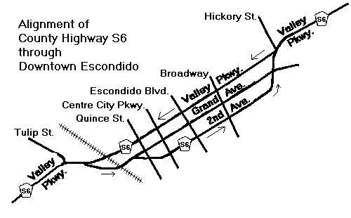
 S6 starts at San Diego County Route S21 in Del Mar as Via de la Valle. It crosses Interstate 5 and meets with S8 in Rancho Santa Fe
at the intersection of Via de la Valle and Paseo Delicias. At El Camino Del Norte the name changes to Del Dios Highway, past the community of Del Dios and into Escondido, California
.
In Escondido, S6 runs along West and East Valley Parkways, to Valley Center Road through Valley Center, California
. S6 ends at State Route 76
.
About four miles (6 km) east on SR 76, S6 begins again as South Grade Road, which winds northward on Palomar Mountain
. It intersects with S7, then continues north until it ends at the Palomar Observatory
.
 The route was defined in 1959.
in San Diego County, California
that provides access to Palomar Mountain
.
east of Pauma Valley, California
. It begins as a dirt road known as the Nate Harrison Grade. Then it returns to pavement as it ascends Palomar Mountain and meets San Diego County Route S6. It enters Palomar Mountain State Park. Then, it descends to end at SR 76 near Lake Henshaw
.
Nate Harrison Grade is not signed as County Route S7, but it is a logical westward extension of the signed portion. With a 10% grade, it was the only road to the top of Palomar Mountain until the 1940s, when East Grade Road ("Highway to the Stars") was built for the construction of the Palomar Observatory
. The road was formerly known as "Nigger Nate Road", named after Nate Harrison, an early African-American homesteader. The name was changed in 1956 at the request of the NAACP.
On a small turnout is a monument to Gregory Pacheco and a good view to the north. According to a plaque at the monument, pictured below, Gregory Pacheco was a firefighter who died in the
La Jolla Fire in 1999. The descent on the eastern side of Palomar Mountain offers panoramic views of Lake Henshaw
.
. Its western end is County Route S21 and its eastern end is at Via De La Valle in Rancho Santa Fe
.
The route begins in Solana Beach, California
at Old Highway 101. It winds eastward through San Diego County, crossing through the cities of Solana Beach
and San Diego
and ends at Via De La Valle.
The route was established in 1959.
. Its west end is at County Route S21 and it ends at Paseo Delicias.
The route was defined in 1959.
in San Diego
.
S10 begins at Encinitas Blvd in Encinitas
, heading in a generally northward direction. It enters Carlsbad and turns eastward. This road travels into San Marcos
and passes near the unincorporated area of Lake San Marcos
. (The entire run of the road past Carlsbad is located in parts of the incorporated city of San Marcos; often, at this point, the incorporated portions only follow the road, leaving unincorporated islands nearby.) Rancho Santa Fe intersects with San Marcos Blvd, and ocontinues northward. There is a junction with State Route 78
. A short distance north, Rancho Santa Fe ends at County Route S14 (which changes names from Santa Fe Ave to Mission Rd at the intersection).
The route was established in 1959.
in San Diego
.
S11's southern terminus is Encinitas Boulevard (S9) in Encinitas
. It continues northward through Encinitas, intersecting with Lecuadia Blvd/Olivenhain Rd, which becomes County Route S10 at this intersection. After this point, it enters Carlsbad, where it intersects with Palomar Airport Rd. It continues northward through Carlsbad, ending at State Route 78
in Oceanside
.
This is the portion of the road that is officially designated S11. Note that El Camino Real continues for several miles beyond both termini. It extends southward through Encinitas until it reaches San Elijo Lagoon
and ends at Interstate 5. Northward in Oceanside, El Camino Real continues until State Route 76
; past this point, the road ends. Originally, it actually turned around and began to go southward, parallel to its main route, but signed as Rancho del Oro Rd, ending at Vista Way just north of State Route 78 in Oceanside. However, two locked gates as part of the Mission San Luis Rey de Francia
make this impossible.
The route was established in 1959.
in San Diego
.
S12's western terminus is at Carlsbad Blvd in Carlsbad
. Almost immediately after it begins, S12 (this portion of which is called "Palomar Airport Rd") intersects with Interstate 5. It continues eastward, passing its namesake, McClellan-Palomar Airport
. It intersects with El Camino Real and eventually enters San Marcos
, where it is renamed San Marcos Blvd after an intersection with Business Park Dr. San Marcos Blvd intersects Rancho Santa Fe Rd and continues eastward, crossing State Route 78
. Shortly thereafter, San Marcos Blvd intersects with Twin Oaks Valley Road, which bears the S12 designation after this junction. Shortly after becoming S12, Twin Oaks Valley Rd passes over Mission Rd (County Route S14) without actually intersecting it, then continues to the northern borders of San Marcos. At the edge of the city, Twin Oaks Valley Rd narrows into a private road, and S12 bears right to become Deer Springs Rd, which continues northward through unincorporated land. Eventually the road turns east, and S12 ends at an interchange with Interstate 15, though the road itself continues as Mountain Meadow Rd through Hidden Meadows
.
The route was established in 1961.
in San Diego
. It is distinctive for having a three-mile (5 km) discontinuity in Bonsall
.
S13's southern terminus is at SR 78
in Vista
, where the street is known as Vista Village Drive. This section of S13 is the northern boundary of the newly renovated downtown area of Vista, and in this area the road intersects with Santa Fe Avenue, which is San Diego County Route S14. Shortly afterwards, the road's name changes to East Vista Way, and continues northward outside the city limits into the unincorporated community of Bonsall
.
S13 is unusual in that, according to official legislation, its route is discontinuous. In Bonsall, East Vista Way meets SR 76
and, from this point, loses its status as Route S13. Nearly three miles northeast on SR 76, S13 begins again, continuing northward, but as South Mission Road.
Mission Road cuts north through Bonsall and passes the neighborhoods of San Luis Rey Heights and Winterwarm before entering Fallbrook
. In Fallbrook, South Mission Road splits off into South Main Avenue, which carries the S13 signage. These two streets run parallel to each other for several blocks; East Fallbrook Rd (S15) begins at Mission and intersects Main. After a short distance, Mission turns east, intersecting Main; Mission then continues as S13. S13 continues eastward, ending at an interchange with Interstate 15.
Almost all of S13, except for later realigned portions, is an old alignment of U.S. Route 395
, and Historic Route signs are posted in unincorporated areas.
The route was established in 1968.
 County Route S14, also known as Santa Fe Avenue and Mission Road, runs through North County
in San Diego
.
S14's western terminus is at State Route 76
in Oceanside
, where it is known as Santa Fe Avenue. It travels into Vista
, intersecting with County Route S13, or Vista Village Drive, in downtown Vista. At this point it begins to run parallel to State Route 78
, which it does until its terminus. Santa Fe travels into western San Marcos
, where it intersects with County Route S10 (Rancho Santa Fe Rd); it is at this intersection that Santa Fe becomes Mission Rd. Mission continues through San Marcos, passing under Twin Oaks Valley Road (County Route S12) without an intersection. In eastern San Marcos, Mission crosses State Route 78 without an intersection. Shortly afterward, it enters Escondido
, where it crosses Interstate 15, again with no intersection. Shortly after this point, the freeway portion of SR 78 ends and that route turns right onto Broadway; S14 intersects with and ends at Broadway.
S14 east of S13, except for later realigned portions, is an old alignment of U.S. Route 395
, and Historic Route signs are posted in unincorporated areas.
The route was established in 1968.
. Its west end is County Route S13 and its east end is at Interstate 15
.
The route was established in 1959.
. Its south end is SR 76
and its north end is SR 79
.
The route has its southern terminus at SR 76
in the Pala Indian Reservation
, in the San Luis Rey River Valley. It continues northward as Pala Temecula Road, and when it crosses the county line and enters Riverside County
, it is renamed as Pala Road. It winds through Temecula
and finally ends as Pechanga Parkway at SR 79
.
The route was established in 1959.
and El Cajon
. The route consists of portions of several roads passing through the cities of Chula Vista and El Cajon, and the unincorporated communities of Bonita
, Spring Valley, and Rancho San Diego.
County Route S17 roughly parallels State Route 54
from Interstate 5 east to State Route 125
, running along E Street, Bonita Road, Sweetwater Road, South Worthington Street, and Paradise Valley Road. The route then shares the same alignment as State Route 54, from State Route 125 northeast to the El Cajon city limit, running along Jamacha Boulevard, Campo Road, and Jamacha Road. Within El Cajon, County Route S17 shares the same alignment as the former State Route 54, continuing north to Interstate 8 along Jamacha Road and 2nd Street.
The portions of County Route S17 within the cities of Chula Vista and El Cajon are no longer signed. The portions of the route within Bonita and Spring Valley are signed. However, all signs in Rancho San Diego (along Campo and Jamacha Roads) appear to have been removed except for the one heading east coming from the terminus of the freeway portion of State Route 94
. In El Cajon city limits, the route is signed with Business Route 54.
The route was established in 1964.
in the U.S. state
of California
in Orange County
. The route follows El Toro Road and proceeds in a boomerang
-like pattern from State Route 133
in Laguna Beach to State Route 55
near Orange
. CR S18 traverses as a loop around the urban area
s of Orange County and cuts through the Santa Ana Mountains
. The road is one of four county routes in Orange County that are signed in areas nearby the route, such as southbound Interstate 5 and southbound State Route 133
. It is also noted to be the longest county route in Orange County and is the only major route that allows motorists to drive through, in, and out of the Santa Ana Mountains.
The Santiago Canyon Road portion of CR S18 in the Santa Ana Mountains is planned to become designated as an official scenic highway as part of the State Scenic Highway System
. This makes it the second highway to become designated as a scenic road in Orange County, California
, despite the impact from the Santiago Fire
as part of the wildfires in October 2007
.
Major intersections
The entire route is in Orange County
.
{| class=wikitable
!Location
!Mile
!Destinations
!Notes
|-
|Laguna Beach
|0.00
|Laguna Canyon Road (SR 133
) – Laguna Beach
, Irvine
|
|-
|rowspan=2|Aliso Viejo
|0.80
|
|Interchange
|-
|1.45
|Aliso Creek Road
|
|-
|Laguna Woods
|3.03
|Moulton Parkway
|
|-
|Laguna Hills
|4.14
|
|Interchange; former US 101
|-
|rowspan=2|Lake Forest
|6.35
|Trabuco Road
|
|-
|8.75
|Santa Margarita Parkway, Portola Parkway
|
|-
|
|11.53
| – O'Neill Regional Park, Trabuco Oaks
, Coto de Caza
|
|-
|
|
|Silverado Canyon Road – Silverado Canyon, Black Star Canyon
|
|-
|
|22.82
|, South County
|Interchange
|-
|Villa Park
|23.83
|Jamboree Road
|
|-
|rowspan=2|Orange
|29.05
|
|Interchange
|-
|29.05
|Katella Avenue
|Continuation beyond SR 55
in the U.S. state
of California
in Orange County
. The route follows Live Oak Canyon Road from O'Neill Park to El Toro Road (S18) to Trabuco Canyon
.
County Route S19 is notorious for many fatal accidents that have occurred in the recent years since 2000, and many lost lives due to such accidents.
The route was established in 1961.
in the U.S. state
of California
. As the only county route in Santa Barbara County
, it was deleted in 1988 and became part of State Route 1
.
serving the coastal communities of northern San Diego County, running from San Diego
in the south to Oceanside
in the north. The route is signed in many places as "Historic Route 101" with the official Historic U.S. 101 shields. S21 follows the prior alignment of U.S. Route 101
through this region. The route is also called "Coast Highway" in some places as well. This route was originally designated in 1968 and is 24.74 miles (39.8 km) long.
.svg.png) County Route S21 begins at Interstate 5
County Route S21 begins at Interstate 5
in the north of San Diego as Genesee Avenue. The road then travels north into Del Mar it is called "Camino Del Mar". While in Del Mar the route passes both the historic Del Mar Racetrack
and through the historic downtown of Del Mar. In Solana Beach
the route moves closer to the coast. Along this stretch it is named "Highway 101" and the city has signed the route along its length with faux U.S. Highway shields that resemble the official U.S. 101 shields in use today along with the state issued Historic 101 shield. While to the north in Encinitas
the route's name becomes "Coast Highway 101" also in homage to the old U.S. Route. In Carlsbad
it becomes "Carlsbad Blvd". The route is named "Coast Highway" in Oceanside, and comes to an end at Interstate 5
in Camp Pendleton.
The section of this road between La Costa and Palomar Airport Road was once known as the Carlsbad Freeway. The majority of the route from the Del Mar city limit to Hill Street in Oceanside are signed as Historic U.S. 101 and is also an unsigned Business Route Interstate 5.
The route was established in 1968.
and then descends for approximately 12 miles (19.3 km) to the desert community of Borrego Springs
, offering magnificent views of the Borrego Valley as it winds steeply down Montezuma Grade.
As it enters Borrego Springs, the highway turns right onto Palm Canyon Drive. In the middle of Borrego Springs, it passes through the only large traffic circle in San Diego County.
It continues east, changes its name to the Borrego-Salton Seaway, enters Imperial County, runs through Anza-Borrego State Park and ends at a junction with State Route 86
in Salton City
, a community on the shore of the Salton Sea.
The route was established in 1968.
in the U.S. state
of California
in southeast Imperial County, California
. It is north, across the Colorado River
and adjacent to Yuma, Arizona
, serving the city of Winterhaven
. The southern two-thirds of the route travels through the Quechan Indian Tribal
lands of the Fort Yuma Indian Reservation
.
, adjacent to the eastern exit of Interstate 8 in California at Winterhaven. The route travels northeast through portions of eastern Winterhaven, then immediately turns north through farmland, for 2.8 miles (5 km); (the continuation north exiting this route accesses the southern Chocolate Mountains
, and the western perimeter of the Little Picacho Wilderness
, a dirt road, sometimes rugged, wash-boarded and difficult). The route turns east 3.5 miles (6 km) then north, east, then north on a newly paved stretch through farmland for 1.5 miles (2 km). The final turn east is through farmland for 1.3 miles (2 km) then a northeast stretch along the western shoreline of the Colorado River
, Laguna Dam and a terminus at the 1.1 mi (1.8 km) turn-off to Imperial Dam
; the river stretch is about 8 miles (13 km), and seasonally has osprey
, phainopepla
, Abert's towhee
, belted kingfisher
, double-crested cormorant
, and everpresent Gambel's quail
, plus numerous other bird species, including the water bird
s. Of note, the osprey have snag
perches along the river route, and can be seen eating fish on pole tops, towers, etc.
The terminus at the Laguna Dam turn-off transitions into the extension westwards in southwest Arizona from U.S. 95 in Arizona, westwards on Imperial Dam Road of Yuma County, Arizona
and the US Army Yuma Proving Ground.
No traffic lights occur on the route; only one stop sign is encountered while traveling north to south; (–except that one 4-way stop is encountered at about 1.7 north of Winterhaven). 1.5 miles (2.4 km) south of the Imperial Dam entrance, the Ferguson Lake Road and the Senator Wash access exits to the northwest. The eastern access points to the Little Picacho Wilderness
can be found along the northern sections of Ferguson Lake Road, (a sometimes rugged, wash-boarded dirt road).
The route was established in 1970.
Route S24 serves as a second access route to the Yuma Proving Ground, and also to the main housing and administration
center of YPG. The route is also the main access to the housing facilities in the Imperial Dam region, administered by the Bureau of Land Management
; the Imperial Dam housing region is on the Arizona side of the Colorado River.
in Imperial County
, California
. It was once a portion of U.S. Route 80
, which no longer enters the state. S80 travels through Imperial County
for 34.46 miles (55.5 km) to the vicinity of the Colorado River
near Yuma
, Arizona
.
 S80 begins in the west at the junction of S80 and Imperial County Route S2 as the Evan Hewes Highway roughly paralleling the route of Interstate 8. This portion of the highway travels 25 miles (40.2 km) east to El Centro
.
In downtown El Centro S80 becomes Adams Avenue. At Imperial Avenue S80 junctions with State Route 86
from the north and Business Loop I-8 from the south. The roads run concurrent down Adams Ave and all three turn south along 4th Street. S80 then turns to the east along Main Street which takes it out of El Centro while State Route 86 and Business I-8 continue south. Outside of El Centro after its junction with Imperial County Route S31, S80 resumes the designation of Evan Hewes Highway. S80 also intersects State Route 111
along this stretch. S80 continues east until it reaches its terminus at the junction with State Route 115
. State Route 115 continues along the Evan Hewes Hwy and old U.S. Route 80.
In 2006, the California legislature
, as part of concurrent resolution
ACR 123, made the former Route 80, including County Route S80, an official historic route.
For the short distance S80 runs concurrent with SR 86 it is part of the Juan Bautista de Anza National Historic Trail
. This trail runs along the route Juan Bautista de Anza
took along his expedition into California from 1775-76.
County routes in California
In the U.S. state of California, county routes are controlled and maintained by the respective counties in which they reside. However, they are generally patrolled by the state's California Highway Patrol....
. The "S" zone includes county highways lying in the counties of Imperial
Imperial County, California
Imperial County is a county located in the Imperial Valley, in the far southeast of the U.S. state of California, bordering both Arizona and Mexico. It is part of the El Centro Metropolitan Area, which encompasses all of Imperial County. The population as of 2000 was 142,361. The county seat is the...
, Orange
Orange County, California
Orange County is a county in the U.S. state of California. Its county seat is Santa Ana. As of the 2010 census, its population was 3,010,232, up from 2,846,293 at the 2000 census, making it the third most populous county in California, behind Los Angeles County and San Diego County...
, Riverside
Riverside County, California
Riverside County is a county in the U.S. state of California. One of 58 California counties, it covers in the southern part of the state, and stretches from Orange County to the Colorado River, which forms the state border with Arizona. The county derives its name from the city of Riverside,...
, San Diego
San Diego County, California
San Diego County is a large county located in the southwestern corner of the US state of California. Hence, San Diego County is also located in the southwestern corner of the 48 contiguous United States. Its county seat and largest city is San Diego. Its population was about 2,813,835 in the 2000...
, and Santa Barbara
Santa Barbara County, California
Santa Barbara County is a county located in the southern portion of the U.S. state of California, on the Pacific coast. As of 2010 the county had a population of 423,895. The county seat is Santa Barbara and the largest city is Santa Maria.-History:...
.
S1
County Route S1, also known as Sunrise Highway for a portion of its length, is a 34.08 mi (54.85 km) long county route located entirely in San Diego CountySan Diego County, California
San Diego County is a large county located in the southwestern corner of the US state of California. Hence, San Diego County is also located in the southwestern corner of the 48 contiguous United States. Its county seat and largest city is San Diego. Its population was about 2,813,835 in the 2000...
, California
California
California is a state located on the West Coast of the United States. It is by far the most populous U.S. state, and the third-largest by land area...
. It begins at SR 94
California State Route 94
State Route 94 in the U.S. state of California is the Martin Luther King Jr. Freeway from Interstate 5 in Downtown San Diego to the end of the freeway portion past Route 125 in Spring Valley; the non-freeway segment of SR 94 is Campo Road....
near Barrett and moves northward across Interstate 8. This segment is also known as Buckman Springs Road. North of I-8, it is the Sunrise Scenic Byway, a National Forest Scenic Byway.
Route description
California State Route 94
State Route 94 in the U.S. state of California is the Martin Luther King Jr. Freeway from Interstate 5 in Downtown San Diego to the end of the freeway portion past Route 125 in Spring Valley; the non-freeway segment of SR 94 is Campo Road....
near Barrett not far from the Mexican
Mexico
The United Mexican States , commonly known as Mexico , is a federal constitutional republic in North America. It is bordered on the north by the United States; on the south and west by the Pacific Ocean; on the southeast by Guatemala, Belize, and the Caribbean Sea; and on the east by the Gulf of...
border. From there, it heads northward along Buckman Springs Road. Soon afterwards, it enters the Cleveland National Forest
Cleveland National Forest
Cleveland National Forest encompasses 460,000 acres , mostly of chaparral, with a few riparian areas. A warm dry mediterranean climate prevails over the Forest. It is the southernmost National forest of California. It is administered by the United States Forest Service, a government agency within...
. When the road reaches Interstate 8
Interstate 8
Interstate 8 is an Interstate Highway in the southwestern United States. It runs from the southern edge of Mission Bay at Sunset Cliffs Blvd, in San Diego, California, almost at the Pacific Ocean, to the junction with Interstate 10, just southeast of Casa Grande, Arizona...
, while Buckman Springs Road continues northeastward across the freeway, CR S1 continues in a northwest direction along Old Highway 80, the original alignment of U.S. Route 80
U.S. Route 80
U.S. Route 80 is an east–west United States highway, much of which was once part of the early auto trail known as the Dixie Overland Highway. As the "0" in the route number indicates, it was originally a cross-country route, from the Atlantic to the Pacific...
in California. It then closely parallels I-8
Interstate 8
Interstate 8 is an Interstate Highway in the southwestern United States. It runs from the southern edge of Mission Bay at Sunset Cliffs Blvd, in San Diego, California, almost at the Pacific Ocean, to the junction with Interstate 10, just southeast of Casa Grande, Arizona...
for several miles. Upon crossing the freeway at Laguna Junction, CR S1 separates from Old Highway 80 and becomes Sunrise Scenic Byway.
Pine Valley, California
Pine Valley is a community and census-designated place in the Mountain Empire area of southeastern San Diego County, California. The population was 1,510 at the 2010 census, up from 1,501 at the 2000 census.-Geography:...
to its west. Around here, the vegetation is still consisted of chaparral
Chaparral
Chaparral is a shrubland or heathland plant community found primarily in the U.S. state of California and in the northern portion of the Baja California peninsula, Mexico...
and sagebrush
Sagebrush
Sagebrush is a common name of a number of shrubby plant species in the genus Artemisia native to western North America;Or, the sagebrush steppe ecoregion, having one or more kinds of sagebrush, bunchgrasses and others;...
. As the route gains elevation through Cleveland National Forest
Cleveland National Forest
Cleveland National Forest encompasses 460,000 acres , mostly of chaparral, with a few riparian areas. A warm dry mediterranean climate prevails over the Forest. It is the southernmost National forest of California. It is administered by the United States Forest Service, a government agency within...
, the route becomes more heavily forested. Around here, numerous campgrounds dot the side of the road. There exists a picnic area overlooking Anza-Borrego Desert State Park
Anza-Borrego Desert State Park
Anza-Borrego Desert State Park is a state park located within the Colorado Desert of Southern California. The park takes its name from 18th century, Spanish explorer Juan Bautista de Anza and borrego, the Spanish word for bighorn sheep...
near the Burnt Rancheria Campground, which is often said to deeply contrast the forest scenery along the route. Upon passing the settlement of Laguna Mountain, the vegetation along the route mostly consists of dead trees devastated by the 2003 Cedar Fire
Cedar Fire
The Cedar Fire was a human-caused wildfire that burned out of control through a large area of San Diego County, in Southern California, in October 2003...
.
As the route approaches its north end at SR 79
California State Route 79
State Route 79 is a state highway in the U.S. state of California. The route goes from Interstate 10 in Riverside County to Interstate 8 in San Diego County.-Route description:...
, Lake Cuyamaca is visible. The north terminus is located just north of Cuyamaca Rancho State Park
Cuyamaca Rancho State Park
Cuyamaca Rancho State Park is a state park located forty miles east of San Diego, California in the Laguna Mountains of the Peninsular Ranges. The park's 26,000 acres feature pine, fir, and oak forests, with meadows and streams that exist due to the relatively high elevation of the area compared...
.
History
S2
County Route S2 (CR S2) is a county highwayCounty highway
A county highway is a road in the United States and in the Canadian province of Ontario that is designated and/or maintained by the county highway department...
in the U.S. state
U.S. state
A U.S. state is any one of the 50 federated states of the United States of America that share sovereignty with the federal government. Because of this shared sovereignty, an American is a citizen both of the federal entity and of his or her state of domicile. Four states use the official title of...
of California
California
California is a state located on the West Coast of the United States. It is by far the most populous U.S. state, and the third-largest by land area...
. It runs for 65 miles (104.6 km), north–south, in Imperial County and San Diego County. S2 is the third longest county route in California
California
California is a state located on the West Coast of the United States. It is by far the most populous U.S. state, and the third-largest by land area...
and is almost exclusively a two-lane rural road.
Route description
Ocotillo, California
Ocotillo, California
Ocotillo is a census-designated place in Imperial County, California. Ocotillo is located west of El Centro, The population was 266 at the 2010 census, down from 296 at the 2000 census...
, and runs north through an interchange with
Interstate 8. This part is also called Imperial Highway. The highway crosses into San Diego County and its name changes to Sweeney Pass Road. Farther north, the name of the highway changes to the Great Southern Overland Stage Route of 1849 at a remote junction. The highway then crosses State Route 78
California State Route 78
State Route 78 is a state highway in the U.S. state of California in the United States that runs from Oceanside east to Blythe, traversing nearly the entire width of the state. Its western terminus is at Interstate 5 in San Diego County and its eastern terminus is at I-10 in Riverside County...
at Scissors Crossing in a desert community now called Shelter Valley
Shelter Valley, California
Shelter Valley is an unincorporated area located in San Diego County in U.S. state of California. The town is located along county road S2, two miles south of its intersection with California State Route 78 and 12 miles east of Julian, CA...
(formerly called Earthquake Valley
Earthquake Valley
Earthquake Valley is a desert valley east of Julian, California, which contains parts of the Anza-Borrego Desert State Park. It is the location of the Shelter Valley Ranchos subdivision, which is also known as the unincorporated community of Shelter Valley...
), and its name changes to San Felipe Road. The highway ends at a junction with State Route 79
California State Route 79
State Route 79 is a state highway in the U.S. state of California. The route goes from Interstate 10 in Riverside County to Interstate 8 in San Diego County.-Route description:...
near the community of Warner Springs.
S3
County Route S3 begins at a junction with State Route 78California State Route 78
State Route 78 is a state highway in the U.S. state of California in the United States that runs from Oceanside east to Blythe, traversing nearly the entire width of the state. Its western terminus is at Interstate 5 in San Diego County and its eastern terminus is at I-10 in Riverside County...
and runs roughly north over Yaqui Pass to Borrego Springs
Borrego Springs, California
Borrego Springs is a census-designated place in San Diego County, California. The population was 3,429 at the 2010 census, up from 2,535 at the 2000 census. Many residents are seasonal while others remain year round...
, bearing the name Yaqui Pass Road. It turns left onto Deep Well Trail and left again onto Borrego Springs Road. It ends at a junction with County Route S22 called Christmas Circle. Its total length is 12.1 miles (19.5 km).
There is one call box on this highway. It is at Yaqui Pass summit.
The highway is part of the Juan Bautista de Anza National Historic Trail
Juan Bautista de Anza National Historic Trail
thumb|325px|MAP: [[Juan Bautista de Anza]] National Historic Trail routes in [[Arizona]] and [[California]].The Juan Bautista de Anza National Historic Trail is a National Park Service unit in the United States National Historic Trail and National Millennium Trail programs...
Auto Tour Route.
S4
County Route S4 is a road in the northern city limits of San Diego, CaliforniaSan Diego, California
San Diego is the eighth-largest city in the United States and second-largest city in California. The city is located on the coast of the Pacific Ocean in Southern California, immediately adjacent to the Mexican border. The birthplace of California, San Diego is known for its mild year-round...
. The route traverses across Interstate 15
Interstate 15 in California
In the U.S. state of California, Interstate 15 is a major north–south route through the San Bernardino, Riverside, and San Diego Counties, and it has a length of in the state. It is a major thoroughfare for traffic between Southern California and Las Vegas, Nevada, as well as points beyond...
as Poway Road east to State Route 67
California State Route 67
State Route 67 runs from Interstate 8 in El Cajon to Lakeside as the San Vicente Freeway. It then becomes a smaller roadway through Poway and becomes Main Street in Ramona before ending into State Route 78....
.
The west end is at Interstate 15
Interstate 15
Interstate 15 is the fourth-longest north–south Interstate Highway in the United States, traveling through the states of California, Nevada, Arizona, Utah, Idaho, and Montana from San Diego to the Canadian border...
, where the road continues west, not as Route S4, but as Rancho Penasquitos Blvd, traverses across California State Route 56
California State Route 56
State Route 56 runs from Interstate 5 in the Carmel Valley neighborhood of San Diego to Interstate 15. Route 56 was originally planned in 1964 to connect to the north end of State Route 125 and continue east to State Route 67, but the city of Poway worked to make sure that would not be possible...
, and finally ends as Carmel Mountain Road. Eastward, the road traverses through the city of Poway
Poway, California
Poway is a city in San Diego County, California. Originally an unincorporated community in San Diego County, Poway officially became a city in December 1980. Even though Poway lies geographically in the middle of San Diego County, most consider its relative location as north county inland...
with the name Poway Road and has its east end at CA SR 67
California State Route 67
State Route 67 runs from Interstate 8 in El Cajon to Lakeside as the San Vicente Freeway. It then becomes a smaller roadway through Poway and becomes Main Street in Ramona before ending into State Route 78....
. Within Poway, it is one of the busiest streets in the city of Poway.
The route was established in 1959.
S5
San Diego County Route S5 is a road in both Poway, CaliforniaPoway, California
Poway is a city in San Diego County, California. Originally an unincorporated community in San Diego County, Poway officially became a city in December 1980. Even though Poway lies geographically in the middle of San Diego County, most consider its relative location as north county inland...
and San Diego, California
San Diego, California
San Diego is the eighth-largest city in the United States and second-largest city in California. The city is located on the coast of the Pacific Ocean in Southern California, immediately adjacent to the Mexican border. The birthplace of California, San Diego is known for its mild year-round...
. Its south end is County Route S4 and north end is Interstate 15
Interstate 15
Interstate 15 is the fourth-longest north–south Interstate Highway in the United States, traveling through the states of California, Nevada, Arizona, Utah, Idaho, and Montana from San Diego to the Canadian border...
.
The road's south end is at County Route S4 in Poway. It winds north through Poway as Espola Road and then turns slightly west, ending at Interstate 15. Past I-15 is the continuation of Rancho Bernardo Road.
The route was established in 1959.
S6
County Route S6 is a county route in San Diego County, CaliforniaCalifornia
California is a state located on the West Coast of the United States. It is by far the most populous U.S. state, and the third-largest by land area...
. It connects Del Mar
Del Mar, California
Del Mar is an upscale beach town in San Diego County, California. The population was 4,161 at the 2010 census, down from 4,389 at the 2000 census. The San Diego County Fair is hosted on the Del Mar Fairgrounds every summer. Del Mar is Spanish for "of the sea" or "by the sea", because it is located...
with Palomar Mountain
Palomar Mountain
Palomar Mountain is a mountain in the Peninsular Ranges in northern San Diego County. It is famous as the location of the Palomar Observatory and Hale Telescope, and known for the Palomar Mountain State Park.-History:...
across San Diego County. It is one of few San Diego County Routes with a discontinuity in its routing.
Rancho Santa Fe, California
Rancho Santa Fe known locally as ″The Ranch″, is one of the most exclusive and affluent communities in Southern California. It is also a census-designated place in San Diego County, California and an unincorporated bedroom community of San Diego County...
at the intersection of Via de la Valle and Paseo Delicias. At El Camino Del Norte the name changes to Del Dios Highway, past the community of Del Dios and into Escondido, California
Escondido, California
Escondido is a city occupying a shallow valley ringed by rocky hills, just north of the city of San Diego, California. Founded in 1888, it is one of the oldest cities in San Diego County. The city had a population of 143,911 at the 2010 census. Its municipal government set itself an operating...
.
In Escondido, S6 runs along West and East Valley Parkways, to Valley Center Road through Valley Center, California
Valley Center, California
Valley Center is a census-designated place in San Diego County, California. The population was 9,277 at the 2010 census, up from 7,323 at the 2000 census.-Geography:Valley Center is located at ....
. S6 ends at State Route 76
California State Route 76
State Route 76 is a state highway in the U.S. state of California. It is an important east–west route in the North County region of San Diego County that begins in Oceanside near Interstate 5 and continues east past Interstate 15 to State Route 79...
.
About four miles (6 km) east on SR 76, S6 begins again as South Grade Road, which winds northward on Palomar Mountain
Palomar Mountain
Palomar Mountain is a mountain in the Peninsular Ranges in northern San Diego County. It is famous as the location of the Palomar Observatory and Hale Telescope, and known for the Palomar Mountain State Park.-History:...
. It intersects with S7, then continues north until it ends at the Palomar Observatory
Palomar Observatory
Palomar Observatory is a privately owned observatory located in San Diego County, California, southeast of Pasadena's Mount Wilson Observatory, in the Palomar Mountain Range. At approximately elevation, it is owned and operated by the California Institute of Technology...
.
S7
County Route S7 is a county routeCounty routes in California
In the U.S. state of California, county routes are controlled and maintained by the respective counties in which they reside. However, they are generally patrolled by the state's California Highway Patrol....
in San Diego County, California
San Diego County, California
San Diego County is a large county located in the southwestern corner of the US state of California. Hence, San Diego County is also located in the southwestern corner of the 48 contiguous United States. Its county seat and largest city is San Diego. Its population was about 2,813,835 in the 2000...
that provides access to Palomar Mountain
Palomar Mountain
Palomar Mountain is a mountain in the Peninsular Ranges in northern San Diego County. It is famous as the location of the Palomar Observatory and Hale Telescope, and known for the Palomar Mountain State Park.-History:...
.
Route description
S7's western terminus is at State Route 76California State Route 76
State Route 76 is a state highway in the U.S. state of California. It is an important east–west route in the North County region of San Diego County that begins in Oceanside near Interstate 5 and continues east past Interstate 15 to State Route 79...
east of Pauma Valley, California
Pauma Valley, California
Pauma Valley is an unincorporated community between Valley Center and Palomar Mountain in San Diego County, California. The name also refers to an agricultural region comprising citrus and avocado groves, several Indian Reservations, casinos, and a country club.The headquarters of the La Jolla...
. It begins as a dirt road known as the Nate Harrison Grade. Then it returns to pavement as it ascends Palomar Mountain and meets San Diego County Route S6. It enters Palomar Mountain State Park. Then, it descends to end at SR 76 near Lake Henshaw
Lake Henshaw
Lake Henshaw is a Reservoir in San Diego County, Californiaat the southeast base of Palomar Mountain, approximately miles northeast of San Diego, California and miles southeast of Los Angeles....
.
Nate Harrison Grade is not signed as County Route S7, but it is a logical westward extension of the signed portion. With a 10% grade, it was the only road to the top of Palomar Mountain until the 1940s, when East Grade Road ("Highway to the Stars") was built for the construction of the Palomar Observatory
Palomar Observatory
Palomar Observatory is a privately owned observatory located in San Diego County, California, southeast of Pasadena's Mount Wilson Observatory, in the Palomar Mountain Range. At approximately elevation, it is owned and operated by the California Institute of Technology...
. The road was formerly known as "Nigger Nate Road", named after Nate Harrison, an early African-American homesteader. The name was changed in 1956 at the request of the NAACP.
On a small turnout is a monument to Gregory Pacheco and a good view to the north. According to a plaque at the monument, pictured below, Gregory Pacheco was a firefighter who died in the
La Jolla Fire in 1999. The descent on the eastern side of Palomar Mountain offers panoramic views of Lake Henshaw
Lake Henshaw
Lake Henshaw is a Reservoir in San Diego County, Californiaat the southeast base of Palomar Mountain, approximately miles northeast of San Diego, California and miles southeast of Los Angeles....
.
S8
San Diego County Route S8 is a road in San Diego County, CaliforniaCalifornia
California is a state located on the West Coast of the United States. It is by far the most populous U.S. state, and the third-largest by land area...
. Its western end is County Route S21 and its eastern end is at Via De La Valle in Rancho Santa Fe
Rancho Santa Fe, California
Rancho Santa Fe known locally as ″The Ranch″, is one of the most exclusive and affluent communities in Southern California. It is also a census-designated place in San Diego County, California and an unincorporated bedroom community of San Diego County...
.
The route begins in Solana Beach, California
Solana Beach, California
Solana Beach is a city in San Diego County, California. The population was 12,867 at the 2010 census.-Geography:Solana Beach is located at ....
at Old Highway 101. It winds eastward through San Diego County, crossing through the cities of Solana Beach
Solana Beach, California
Solana Beach is a city in San Diego County, California. The population was 12,867 at the 2010 census.-Geography:Solana Beach is located at ....
and San Diego
San Diego, California
San Diego is the eighth-largest city in the United States and second-largest city in California. The city is located on the coast of the Pacific Ocean in Southern California, immediately adjacent to the Mexican border. The birthplace of California, San Diego is known for its mild year-round...
and ends at Via De La Valle.
The route was established in 1959.
S9
County Route S9, also known as Encinitas Blvd, is a road in San Diego County, CaliforniaCalifornia
California is a state located on the West Coast of the United States. It is by far the most populous U.S. state, and the third-largest by land area...
. Its west end is at County Route S21 and it ends at Paseo Delicias.
The route was defined in 1959.
S10
County Route S10, also known as Rancho Santa Fe Rd, runs through North CountyNorth San Diego County, California
North County is a region in the northern area of San Diego County, California. It is the second most populous region in the county after San Diego, with an estimated population of 826,985. North County is well known for its affluence, especially in Cardiff-by-the-Sea, Carlsbad, Del Mar, Rancho...
in San Diego
San Diego County, California
San Diego County is a large county located in the southwestern corner of the US state of California. Hence, San Diego County is also located in the southwestern corner of the 48 contiguous United States. Its county seat and largest city is San Diego. Its population was about 2,813,835 in the 2000...
.
S10 begins at Encinitas Blvd in Encinitas
Encinitas, California
Encinitas is a coastal beach city in San Diego County, California. Located within Southern California, it is approximately north of San Diego in North County and about south of Los Angeles. As of the 2010 census, the city had a population of 59,518, up from 58,014 at the 2000 census. Encinitas is...
, heading in a generally northward direction. It enters Carlsbad and turns eastward. This road travels into San Marcos
San Marcos, California
San Marcos is a suburb of San Diego in the North County section of San Diego County, California. As of the 2010 census, the city had a total population of 83,781. Outside the San Diego region, it is best known as the home of California State University, San Marcos...
and passes near the unincorporated area of Lake San Marcos
Lake San Marcos, California
Lake San Marcos is a census-designated place in San Diego County, California. It is adjacent of the city of San Marcos. The population was 4,437 at the 2010 census, up from 4,138 at the 2000 census.-Geography:...
. (The entire run of the road past Carlsbad is located in parts of the incorporated city of San Marcos; often, at this point, the incorporated portions only follow the road, leaving unincorporated islands nearby.) Rancho Santa Fe intersects with San Marcos Blvd, and ocontinues northward. There is a junction with State Route 78
California State Route 78
State Route 78 is a state highway in the U.S. state of California in the United States that runs from Oceanside east to Blythe, traversing nearly the entire width of the state. Its western terminus is at Interstate 5 in San Diego County and its eastern terminus is at I-10 in Riverside County...
. A short distance north, Rancho Santa Fe ends at County Route S14 (which changes names from Santa Fe Ave to Mission Rd at the intersection).
The route was established in 1959.
S11
County Route S11, known as El Camino Real, runs through North CountyNorth San Diego County, California
North County is a region in the northern area of San Diego County, California. It is the second most populous region in the county after San Diego, with an estimated population of 826,985. North County is well known for its affluence, especially in Cardiff-by-the-Sea, Carlsbad, Del Mar, Rancho...
in San Diego
San Diego County, California
San Diego County is a large county located in the southwestern corner of the US state of California. Hence, San Diego County is also located in the southwestern corner of the 48 contiguous United States. Its county seat and largest city is San Diego. Its population was about 2,813,835 in the 2000...
.
S11's southern terminus is Encinitas Boulevard (S9) in Encinitas
Encinitas, California
Encinitas is a coastal beach city in San Diego County, California. Located within Southern California, it is approximately north of San Diego in North County and about south of Los Angeles. As of the 2010 census, the city had a population of 59,518, up from 58,014 at the 2000 census. Encinitas is...
. It continues northward through Encinitas, intersecting with Lecuadia Blvd/Olivenhain Rd, which becomes County Route S10 at this intersection. After this point, it enters Carlsbad, where it intersects with Palomar Airport Rd. It continues northward through Carlsbad, ending at State Route 78
California State Route 78
State Route 78 is a state highway in the U.S. state of California in the United States that runs from Oceanside east to Blythe, traversing nearly the entire width of the state. Its western terminus is at Interstate 5 in San Diego County and its eastern terminus is at I-10 in Riverside County...
in Oceanside
Oceanside, California
-2010:The 2010 United States Census reported that Oceanside had a population of 167,086. The population density was 3,961.8 people per square mile...
.
This is the portion of the road that is officially designated S11. Note that El Camino Real continues for several miles beyond both termini. It extends southward through Encinitas until it reaches San Elijo Lagoon
San Elijo Lagoon
San Elijo Lagoon is one of the largest coastal wetlands in San Diego County, California, USA. It is the location of the San Elijo Lagoon Ecological Reserve....
and ends at Interstate 5. Northward in Oceanside, El Camino Real continues until State Route 76
California State Route 76
State Route 76 is a state highway in the U.S. state of California. It is an important east–west route in the North County region of San Diego County that begins in Oceanside near Interstate 5 and continues east past Interstate 15 to State Route 79...
; past this point, the road ends. Originally, it actually turned around and began to go southward, parallel to its main route, but signed as Rancho del Oro Rd, ending at Vista Way just north of State Route 78 in Oceanside. However, two locked gates as part of the Mission San Luis Rey de Francia
Mission San Luis Rey de Francia
Mission San Luis Rey de Francia, also known as Mission San Luis Rey or San Luis Rey Mission Church, was founded on June 13, 1798 in coastal Las Californias, in the present day U.S. city of Oceanside in California. The local Quechnajuichom Native American tribe became known as the Luiseño 'Mission...
make this impossible.
The route was established in 1959.
S12
County Route S12, also known as Palomar Airport Road, San Marcos Boulevard, Twin Oaks Valley Road, and Deer Springs Road, runs through North CountyNorth San Diego County, California
North County is a region in the northern area of San Diego County, California. It is the second most populous region in the county after San Diego, with an estimated population of 826,985. North County is well known for its affluence, especially in Cardiff-by-the-Sea, Carlsbad, Del Mar, Rancho...
in San Diego
San Diego County, California
San Diego County is a large county located in the southwestern corner of the US state of California. Hence, San Diego County is also located in the southwestern corner of the 48 contiguous United States. Its county seat and largest city is San Diego. Its population was about 2,813,835 in the 2000...
.
S12's western terminus is at Carlsbad Blvd in Carlsbad
Carlsbad, California
-2010:The 2010 United States Census reported that Carlsbad had a population of 105,328. The population density was 2,693.1 people per square mile . The racial makeup of Carlsbad was 87,205 White, 1,379 African American, 514 Native American, 7,460 Asian, 198 Pacific Islander, 4,189 from other...
. Almost immediately after it begins, S12 (this portion of which is called "Palomar Airport Rd") intersects with Interstate 5. It continues eastward, passing its namesake, McClellan-Palomar Airport
McClellan-Palomar Airport
McClellan-Palomar Airport , known to locals as Palomar Airport, is a public airport located three miles southeast of the central business district of Carlsbad, a city in San Diego County, California, United States. It is owned by the County of San Diego and serves the northern part of the county...
. It intersects with El Camino Real and eventually enters San Marcos
San Marcos, California
San Marcos is a suburb of San Diego in the North County section of San Diego County, California. As of the 2010 census, the city had a total population of 83,781. Outside the San Diego region, it is best known as the home of California State University, San Marcos...
, where it is renamed San Marcos Blvd after an intersection with Business Park Dr. San Marcos Blvd intersects Rancho Santa Fe Rd and continues eastward, crossing State Route 78
California State Route 78
State Route 78 is a state highway in the U.S. state of California in the United States that runs from Oceanside east to Blythe, traversing nearly the entire width of the state. Its western terminus is at Interstate 5 in San Diego County and its eastern terminus is at I-10 in Riverside County...
. Shortly thereafter, San Marcos Blvd intersects with Twin Oaks Valley Road, which bears the S12 designation after this junction. Shortly after becoming S12, Twin Oaks Valley Rd passes over Mission Rd (County Route S14) without actually intersecting it, then continues to the northern borders of San Marcos. At the edge of the city, Twin Oaks Valley Rd narrows into a private road, and S12 bears right to become Deer Springs Rd, which continues northward through unincorporated land. Eventually the road turns east, and S12 ends at an interchange with Interstate 15, though the road itself continues as Mountain Meadow Rd through Hidden Meadows
Hidden Meadows, California
Hidden Meadows is a census-designated place near Escondido in San Diego County, California. The population was 3,485 at the 2010 census, up from 3,463 at the 2000 census.-Geography:Hidden Meadows is located at ....
.
The route was established in 1961.
S13
County Route S13, also known as Vista Village Drive, East Vista Way, and Mission Road, runs through North CountyNorth San Diego County, California
North County is a region in the northern area of San Diego County, California. It is the second most populous region in the county after San Diego, with an estimated population of 826,985. North County is well known for its affluence, especially in Cardiff-by-the-Sea, Carlsbad, Del Mar, Rancho...
in San Diego
San Diego County, California
San Diego County is a large county located in the southwestern corner of the US state of California. Hence, San Diego County is also located in the southwestern corner of the 48 contiguous United States. Its county seat and largest city is San Diego. Its population was about 2,813,835 in the 2000...
. It is distinctive for having a three-mile (5 km) discontinuity in Bonsall
Bonsall, California
Bonsall is a census-designated place in San Diego County, California. The population was 3,982 at the 2010 census, up from 3,401 at the 2000 census.-Geography:Bonsall is located just east of Oceanside and Camp Pendleton....
.
S13's southern terminus is at SR 78
California State Route 78
State Route 78 is a state highway in the U.S. state of California in the United States that runs from Oceanside east to Blythe, traversing nearly the entire width of the state. Its western terminus is at Interstate 5 in San Diego County and its eastern terminus is at I-10 in Riverside County...
in Vista
Vista, California
Vista is a city in north San Diego County, California. It was incorporated January 28, 1963 and became a charter city on June 13, 2007. Located just seven miles inland from the Pacific Ocean in northern San Diego County, the City of Vista has a Mediterranean climate...
, where the street is known as Vista Village Drive. This section of S13 is the northern boundary of the newly renovated downtown area of Vista, and in this area the road intersects with Santa Fe Avenue, which is San Diego County Route S14. Shortly afterwards, the road's name changes to East Vista Way, and continues northward outside the city limits into the unincorporated community of Bonsall
Bonsall, California
Bonsall is a census-designated place in San Diego County, California. The population was 3,982 at the 2010 census, up from 3,401 at the 2000 census.-Geography:Bonsall is located just east of Oceanside and Camp Pendleton....
.
S13 is unusual in that, according to official legislation, its route is discontinuous. In Bonsall, East Vista Way meets SR 76
California State Route 76
State Route 76 is a state highway in the U.S. state of California. It is an important east–west route in the North County region of San Diego County that begins in Oceanside near Interstate 5 and continues east past Interstate 15 to State Route 79...
and, from this point, loses its status as Route S13. Nearly three miles northeast on SR 76, S13 begins again, continuing northward, but as South Mission Road.
Mission Road cuts north through Bonsall and passes the neighborhoods of San Luis Rey Heights and Winterwarm before entering Fallbrook
Fallbrook, California
Fallbrook is an unincorporated community in northern San Diego County, California. The Fallbrook census-designated place population was 30,534 at the 2010 census, up from 29,100 at the 2000 census....
. In Fallbrook, South Mission Road splits off into South Main Avenue, which carries the S13 signage. These two streets run parallel to each other for several blocks; East Fallbrook Rd (S15) begins at Mission and intersects Main. After a short distance, Mission turns east, intersecting Main; Mission then continues as S13. S13 continues eastward, ending at an interchange with Interstate 15.
Almost all of S13, except for later realigned portions, is an old alignment of U.S. Route 395
U.S. Route 395
U.S. Route 395 is a U.S. Route in the western United States. The southern terminus of the route is in the Mojave Desert at Interstate 15 near Hesperia. The northern terminus is at the Canadian border near Laurier, where the road becomes Highway 395 upon entering British Columbia. At one time, the...
, and Historic Route signs are posted in unincorporated areas.
The route was established in 1968.
S14
North San Diego County, California
North County is a region in the northern area of San Diego County, California. It is the second most populous region in the county after San Diego, with an estimated population of 826,985. North County is well known for its affluence, especially in Cardiff-by-the-Sea, Carlsbad, Del Mar, Rancho...
in San Diego
San Diego County, California
San Diego County is a large county located in the southwestern corner of the US state of California. Hence, San Diego County is also located in the southwestern corner of the 48 contiguous United States. Its county seat and largest city is San Diego. Its population was about 2,813,835 in the 2000...
.
S14's western terminus is at State Route 76
California State Route 76
State Route 76 is a state highway in the U.S. state of California. It is an important east–west route in the North County region of San Diego County that begins in Oceanside near Interstate 5 and continues east past Interstate 15 to State Route 79...
in Oceanside
Oceanside, California
-2010:The 2010 United States Census reported that Oceanside had a population of 167,086. The population density was 3,961.8 people per square mile...
, where it is known as Santa Fe Avenue. It travels into Vista
Vista, California
Vista is a city in north San Diego County, California. It was incorporated January 28, 1963 and became a charter city on June 13, 2007. Located just seven miles inland from the Pacific Ocean in northern San Diego County, the City of Vista has a Mediterranean climate...
, intersecting with County Route S13, or Vista Village Drive, in downtown Vista. At this point it begins to run parallel to State Route 78
California State Route 78
State Route 78 is a state highway in the U.S. state of California in the United States that runs from Oceanside east to Blythe, traversing nearly the entire width of the state. Its western terminus is at Interstate 5 in San Diego County and its eastern terminus is at I-10 in Riverside County...
, which it does until its terminus. Santa Fe travels into western San Marcos
San Marcos, California
San Marcos is a suburb of San Diego in the North County section of San Diego County, California. As of the 2010 census, the city had a total population of 83,781. Outside the San Diego region, it is best known as the home of California State University, San Marcos...
, where it intersects with County Route S10 (Rancho Santa Fe Rd); it is at this intersection that Santa Fe becomes Mission Rd. Mission continues through San Marcos, passing under Twin Oaks Valley Road (County Route S12) without an intersection. In eastern San Marcos, Mission crosses State Route 78 without an intersection. Shortly afterward, it enters Escondido
Escondido, California
Escondido is a city occupying a shallow valley ringed by rocky hills, just north of the city of San Diego, California. Founded in 1888, it is one of the oldest cities in San Diego County. The city had a population of 143,911 at the 2010 census. Its municipal government set itself an operating...
, where it crosses Interstate 15, again with no intersection. Shortly after this point, the freeway portion of SR 78 ends and that route turns right onto Broadway; S14 intersects with and ends at Broadway.
S14 east of S13, except for later realigned portions, is an old alignment of U.S. Route 395
U.S. Route 395
U.S. Route 395 is a U.S. Route in the western United States. The southern terminus of the route is in the Mojave Desert at Interstate 15 near Hesperia. The northern terminus is at the Canadian border near Laurier, where the road becomes Highway 395 upon entering British Columbia. At one time, the...
, and Historic Route signs are posted in unincorporated areas.
The route was established in 1968.
S15
County Route S15 is a county route in San Diego County, CaliforniaCalifornia
California is a state located on the West Coast of the United States. It is by far the most populous U.S. state, and the third-largest by land area...
. Its west end is County Route S13 and its east end is at Interstate 15
Interstate 15
Interstate 15 is the fourth-longest north–south Interstate Highway in the United States, traveling through the states of California, Nevada, Arizona, Utah, Idaho, and Montana from San Diego to the Canadian border...
.
The route was established in 1959.
S16
County Route S16 is a county route in San Diego County and Riverside County, CaliforniaCalifornia
California is a state located on the West Coast of the United States. It is by far the most populous U.S. state, and the third-largest by land area...
. Its south end is SR 76
California State Route 76
State Route 76 is a state highway in the U.S. state of California. It is an important east–west route in the North County region of San Diego County that begins in Oceanside near Interstate 5 and continues east past Interstate 15 to State Route 79...
and its north end is SR 79
California State Route 79
State Route 79 is a state highway in the U.S. state of California. The route goes from Interstate 10 in Riverside County to Interstate 8 in San Diego County.-Route description:...
.
The route has its southern terminus at SR 76
California State Route 76
State Route 76 is a state highway in the U.S. state of California. It is an important east–west route in the North County region of San Diego County that begins in Oceanside near Interstate 5 and continues east past Interstate 15 to State Route 79...
in the Pala Indian Reservation
Pala Indian Reservation
The Pala Indian Reservation is located in the middle San Luis Rey River Valley in northern San Diego County, California, east of the community of Fallbrook, and has been assigned feature ID 272502. Historic variant names used to describe the area include Mission Indian Reservation and Mission...
, in the San Luis Rey River Valley. It continues northward as Pala Temecula Road, and when it crosses the county line and enters Riverside County
Riverside County, California
Riverside County is a county in the U.S. state of California. One of 58 California counties, it covers in the southern part of the state, and stretches from Orange County to the Colorado River, which forms the state border with Arizona. The county derives its name from the city of Riverside,...
, it is renamed as Pala Road. It winds through Temecula
Temecula, California
Temecula is a city in southwestern Riverside County, California, United States with a population of 100,097 according to the 2010 United States Census, making it the lowest populated American city over 100,000 population. It was incorporated on December 1, 1989...
and finally ends as Pechanga Parkway at SR 79
California State Route 79
State Route 79 is a state highway in the U.S. state of California. The route goes from Interstate 10 in Riverside County to Interstate 8 in San Diego County.-Route description:...
.
The route was established in 1959.
S17
County Route S17 (CR S17) runs through San Diego County, connecting Chula VistaChula Vista, California
Chula Vista is the second largest city in the San Diego metropolitan area, the seventh largest city in Southern California, the fourteenth largest city in the State of California, and the seventy seventh largest city in the U.S....
and El Cajon
El Cajon, California
-History:El Cajon is located on the Rancho El Cajon Mexican land grant made in 1845 to María Antonia Estudillo, wife of Miguel Pedrorena. In 1876 Amaziah Lord Knox , a New Englander who had recently moved to California, established a hotel there to serve the growing number of people traveling...
. The route consists of portions of several roads passing through the cities of Chula Vista and El Cajon, and the unincorporated communities of Bonita
Bonita, California
Bonita is a census-designated place in southern San Diego County, California, nestled between the cities of Chula Vista, National City, and San Diego. The population was 12,538 at the 2010 census.-Geography:Bonita is located at ....
, Spring Valley, and Rancho San Diego.
County Route S17 roughly parallels State Route 54
California State Route 54
State Route 54 is a California State Highway in San Diego that connects Interstate 5 to the city of El Cajon. The first section was built circa 1961, and the final section of freeway opened in 2007....
from Interstate 5 east to State Route 125
California State Route 125
State Route 125 is a state highway in the U.S. state of California that currently runs from State Route 905 in Otay Mesa near the U.S.–Mexico border to State Route 52 in Santee....
, running along E Street, Bonita Road, Sweetwater Road, South Worthington Street, and Paradise Valley Road. The route then shares the same alignment as State Route 54, from State Route 125 northeast to the El Cajon city limit, running along Jamacha Boulevard, Campo Road, and Jamacha Road. Within El Cajon, County Route S17 shares the same alignment as the former State Route 54, continuing north to Interstate 8 along Jamacha Road and 2nd Street.
The portions of County Route S17 within the cities of Chula Vista and El Cajon are no longer signed. The portions of the route within Bonita and Spring Valley are signed. However, all signs in Rancho San Diego (along Campo and Jamacha Roads) appear to have been removed except for the one heading east coming from the terminus of the freeway portion of State Route 94
California State Route 94
State Route 94 in the U.S. state of California is the Martin Luther King Jr. Freeway from Interstate 5 in Downtown San Diego to the end of the freeway portion past Route 125 in Spring Valley; the non-freeway segment of SR 94 is Campo Road....
. In El Cajon city limits, the route is signed with Business Route 54.
The route was established in 1964.
S18
County Route S18 (CR S18) is a county highwayCounty highway
A county highway is a road in the United States and in the Canadian province of Ontario that is designated and/or maintained by the county highway department...
in the U.S. state
U.S. state
A U.S. state is any one of the 50 federated states of the United States of America that share sovereignty with the federal government. Because of this shared sovereignty, an American is a citizen both of the federal entity and of his or her state of domicile. Four states use the official title of...
of California
California
California is a state located on the West Coast of the United States. It is by far the most populous U.S. state, and the third-largest by land area...
in Orange County
Orange County, California
Orange County is a county in the U.S. state of California. Its county seat is Santa Ana. As of the 2010 census, its population was 3,010,232, up from 2,846,293 at the 2000 census, making it the third most populous county in California, behind Los Angeles County and San Diego County...
. The route follows El Toro Road and proceeds in a boomerang
Boomerang
A boomerang is a flying tool with a curved shape used as a weapon or for sport.-Description:A boomerang is usually thought of as a wooden device, although historically boomerang-like devices have also been made from bones. Modern boomerangs used for sport are often made from carbon fibre-reinforced...
-like pattern from State Route 133
California State Route 133
State Route 133 is a state highway in the U.S. state of California. It connects SR 1 in Laguna Beach through the San Joaquin Hills with several freeways in Irvine, ending at the SR 241 toll road in the latter city...
in Laguna Beach to State Route 55
California State Route 55
State Route 55 is an 18-mile long north–south highway in the U.S. state of California. The portion of the route built to freeway standards is known as the Costa Mesa Freeway...
near Orange
Orange, California
Southern California is well-known for year-round pleasant weather: - On average, the warmest month is August. - The highest recorded temperature was in 1985. - On average, the coolest month is December. - The lowest recorded temperature was in 1950...
. CR S18 traverses as a loop around the urban area
Urban area
An urban area is characterized by higher population density and vast human features in comparison to areas surrounding it. Urban areas may be cities, towns or conurbations, but the term is not commonly extended to rural settlements such as villages and hamlets.Urban areas are created and further...
s of Orange County and cuts through the Santa Ana Mountains
Santa Ana Mountains
The Santa Ana Mountains are a short peninsular mountain range along the coast of Southern California in the United States. They extend for approximately 36 mi southeast of the Los Angeles Basin largely along the border between Orange and Riverside counties.- Geography :The range starts in the...
. The road is one of four county routes in Orange County that are signed in areas nearby the route, such as southbound Interstate 5 and southbound State Route 133
California State Route 133
State Route 133 is a state highway in the U.S. state of California. It connects SR 1 in Laguna Beach through the San Joaquin Hills with several freeways in Irvine, ending at the SR 241 toll road in the latter city...
. It is also noted to be the longest county route in Orange County and is the only major route that allows motorists to drive through, in, and out of the Santa Ana Mountains.
The Santiago Canyon Road portion of CR S18 in the Santa Ana Mountains is planned to become designated as an official scenic highway as part of the State Scenic Highway System
State Scenic Highway System (California)
The State Scenic Highway System is a list of highways, mainly state highways, that have been designated by the California Department of Transportation as scenic highways. The California State Legislature, primarily through Section 263 of the Streets and Highways Code, makes highways eligible for...
. This makes it the second highway to become designated as a scenic road in Orange County, California
Orange County, California
Orange County is a county in the U.S. state of California. Its county seat is Santa Ana. As of the 2010 census, its population was 3,010,232, up from 2,846,293 at the 2000 census, making it the third most populous county in California, behind Los Angeles County and San Diego County...
, despite the impact from the Santiago Fire
Santiago Fire
The Santiago Fire was an intentionally started wildfire located near Santiago Canyon in Orange County, California, U.S., and one of twenty-three California wildfires of October 2007.-The fire:...
as part of the wildfires in October 2007
October 2007 California wildfires
The October 2007 California wildfires were a series of wildfires that began burning across Southern California on October 20. At least 1,500 homes were destroyed and over 500,000 acres of land burned from Santa Barbara County to the U.S.–Mexico border...
.
Major intersections
The entire route is in Orange County
Orange County, California
Orange County is a county in the U.S. state of California. Its county seat is Santa Ana. As of the 2010 census, its population was 3,010,232, up from 2,846,293 at the 2000 census, making it the third most populous county in California, behind Los Angeles County and San Diego County...
.
{| class=wikitable
!Location
!Mile
!Destinations
!Notes
|-
|Laguna Beach
Laguna Beach, California
Laguna Beach is a seaside resort city and artist community located in southern Orange County, California, United States, approximately southwest of the county seat of Santa Ana...
|0.00
|Laguna Canyon Road (SR 133
California State Route 133
State Route 133 is a state highway in the U.S. state of California. It connects SR 1 in Laguna Beach through the San Joaquin Hills with several freeways in Irvine, ending at the SR 241 toll road in the latter city...
) – Laguna Beach
Laguna Beach, California
Laguna Beach is a seaside resort city and artist community located in southern Orange County, California, United States, approximately southwest of the county seat of Santa Ana...
, Irvine
Irvine, California
Irvine is a suburban incorporated city in Orange County, California, United States. It is a planned city, mainly developed by the Irvine Company since the 1960s. Formally incorporated on December 28, 1971, the city has a population of 212,375 as of the 2010 census. However, the California...
|
|-
|rowspan=2|Aliso Viejo
Aliso Viejo, California
Aliso Viejo is a city in Orange County, California. It had a population of 47,823 as of the 2010 census, up from 40,166 as of the 2000 census. It became Orange County's 34th city on July 1, 2001, the only city in the county to incorporate since 2000...
|0.80
|
|Interchange
|-
|1.45
|Aliso Creek Road
|
|-
|Laguna Woods
Laguna Woods, California
Laguna Woods is a city in Orange County, California, United States. The population was 16,192 at the 2010 census, down from 16,507 at the 2000 census with a median age of 78. About 90% of the city consists of Laguna Woods Village, a retirement community, formerly known as Leisure World...
|3.03
|Moulton Parkway
|
|-
|Laguna Hills
Laguna Hills, California
Laguna Hills is a city located in southern Orange County, California, United States. Its name refers to its proximity to Laguna Canyon and the much older Laguna Beach. Other newer cities nearby—Laguna Niguel and Laguna Woods—are similarly named.-Geography:...
|4.14
|
|Interchange; former US 101
|-
|rowspan=2|Lake Forest
Lake Forest, California
Lake Forest is a city in Orange County, California. The population was 77,264 at the 2010 census.Lake Forest incorporated as a city on December 20, 1991. Prior to a vote of the residents in that year, the community had formerly been known as El Toro since the 1880s...
|6.35
|Trabuco Road
|
|-
|8.75
|Santa Margarita Parkway, Portola Parkway
|
|-
|
|11.53
| – O'Neill Regional Park, Trabuco Oaks
Trabuco Canyon, California
Trabuco Canyon is a small unincorporated community located in the foothills of the Santa Ana Mountains in eastern Orange County, California, and lies partly within the Cleveland National Forest.Trabuco Canyon is north of the town of Rancho Santa Margarita...
, Coto de Caza
Coto de Caza, California
Coto de Caza is a census-designated place and guard-gated private community in Orange County, California. The population was 14,866 at the 2010 census, up from 13,057 at the 2000 census....
|
|-
|
|
|Silverado Canyon Road – Silverado Canyon, Black Star Canyon
Black Star Canyon
Black Star Canyon is a remote mountain canyon in the Santa Ana Mountains, located in eastern Orange County, California. It is a watershed of the Santa Ana River...
|
|-
|
|22.82
|, South County
|Interchange
|-
|Villa Park
Villa Park, California
Villa Park is a city in northern Orange County, California, near and surrounded by the City of Orange, and close to Anaheim Hills, that incorporated in 1962. As of the 2010 Census, the city had a population of 5,812, down from 5,999 at the 2000 census, achieving the status of the smallest city in...
|23.83
|Jamboree Road
Jamboree Road
Jamboree Road is a major route through Orange County, California.-Route description:The southern terminus of Jamboree Road is at Bayside Drive, immediately before Balboa Island. It changes names, into Marine Ave., to make the very short journey over the water that separates Balboa from Newport...
|
|-
|rowspan=2|Orange
Orange, California
Southern California is well-known for year-round pleasant weather: - On average, the warmest month is August. - The highest recorded temperature was in 1985. - On average, the coolest month is December. - The lowest recorded temperature was in 1950...
|29.05
|
|Interchange
|-
|29.05
|Katella Avenue
|Continuation beyond SR 55
S19
County Route S19 (CR S19) is a county highwayCounty highway
A county highway is a road in the United States and in the Canadian province of Ontario that is designated and/or maintained by the county highway department...
in the U.S. state
U.S. state
A U.S. state is any one of the 50 federated states of the United States of America that share sovereignty with the federal government. Because of this shared sovereignty, an American is a citizen both of the federal entity and of his or her state of domicile. Four states use the official title of...
of California
California
California is a state located on the West Coast of the United States. It is by far the most populous U.S. state, and the third-largest by land area...
in Orange County
Orange County, California
Orange County is a county in the U.S. state of California. Its county seat is Santa Ana. As of the 2010 census, its population was 3,010,232, up from 2,846,293 at the 2000 census, making it the third most populous county in California, behind Los Angeles County and San Diego County...
. The route follows Live Oak Canyon Road from O'Neill Park to El Toro Road (S18) to Trabuco Canyon
Trabuco Canyon, California
Trabuco Canyon is a small unincorporated community located in the foothills of the Santa Ana Mountains in eastern Orange County, California, and lies partly within the Cleveland National Forest.Trabuco Canyon is north of the town of Rancho Santa Margarita...
.
County Route S19 is notorious for many fatal accidents that have occurred in the recent years since 2000, and many lost lives due to such accidents.
The route was established in 1961.
S20
County Route S20 (CR S20) is a former county highwayCounty highway
A county highway is a road in the United States and in the Canadian province of Ontario that is designated and/or maintained by the county highway department...
in the U.S. state
U.S. state
A U.S. state is any one of the 50 federated states of the United States of America that share sovereignty with the federal government. Because of this shared sovereignty, an American is a citizen both of the federal entity and of his or her state of domicile. Four states use the official title of...
of California
California
California is a state located on the West Coast of the United States. It is by far the most populous U.S. state, and the third-largest by land area...
. As the only county route in Santa Barbara County
Santa Barbara County, California
Santa Barbara County is a county located in the southern portion of the U.S. state of California, on the Pacific coast. As of 2010 the county had a population of 423,895. The county seat is Santa Barbara and the largest city is Santa Maria.-History:...
, it was deleted in 1988 and became part of State Route 1
California State Route 1
State Route 1 , more often called Highway 1, is a state highway that runs along much of the Pacific coast of the U.S. state of California. It is famous for running along some of the most beautiful coastlines in the world, leading to its designation as an All-American Road.Highway 1 does not run...
.
S21
County Route S21 is a south–north running roadRoad
A road is a thoroughfare, route, or way on land between two places, which typically has been paved or otherwise improved to allow travel by some conveyance, including a horse, cart, or motor vehicle. Roads consist of one, or sometimes two, roadways each with one or more lanes and also any...
serving the coastal communities of northern San Diego County, running from San Diego
San Diego, California
San Diego is the eighth-largest city in the United States and second-largest city in California. The city is located on the coast of the Pacific Ocean in Southern California, immediately adjacent to the Mexican border. The birthplace of California, San Diego is known for its mild year-round...
in the south to Oceanside
Oceanside, California
-2010:The 2010 United States Census reported that Oceanside had a population of 167,086. The population density was 3,961.8 people per square mile...
in the north. The route is signed in many places as "Historic Route 101" with the official Historic U.S. 101 shields. S21 follows the prior alignment of U.S. Route 101
U.S. Route 101
U.S. Route 101, or U.S. Highway 101, is an important north–south U.S. highway that runs through the states of California, Oregon, and Washington, on the West Coast of the United States...
through this region. The route is also called "Coast Highway" in some places as well. This route was originally designated in 1968 and is 24.74 miles (39.8 km) long.
Interstate 5
Interstate 5 is the main Interstate Highway on the West Coast of the United States, running largely parallel to the Pacific Ocean coastline from Canada to Mexico . It serves some of the largest cities on the U.S...
in the north of San Diego as Genesee Avenue. The road then travels north into Del Mar it is called "Camino Del Mar". While in Del Mar the route passes both the historic Del Mar Racetrack
Del Mar Racetrack
Del Mar Racetrack is an American Thoroughbred horse racing track at the Del Mar Fairgrounds in the seaside city of Del Mar, California, 20 miles north of San Diego. Operated by the Del Mar Thoroughbred Club, it is known for the slogan: "Where The Turf Meets The Surf." It was built by a partnership...
and through the historic downtown of Del Mar. In Solana Beach
Solana Beach, California
Solana Beach is a city in San Diego County, California. The population was 12,867 at the 2010 census.-Geography:Solana Beach is located at ....
the route moves closer to the coast. Along this stretch it is named "Highway 101" and the city has signed the route along its length with faux U.S. Highway shields that resemble the official U.S. 101 shields in use today along with the state issued Historic 101 shield. While to the north in Encinitas
Encinitas, California
Encinitas is a coastal beach city in San Diego County, California. Located within Southern California, it is approximately north of San Diego in North County and about south of Los Angeles. As of the 2010 census, the city had a population of 59,518, up from 58,014 at the 2000 census. Encinitas is...
the route's name becomes "Coast Highway 101" also in homage to the old U.S. Route. In Carlsbad
Carlsbad, California
-2010:The 2010 United States Census reported that Carlsbad had a population of 105,328. The population density was 2,693.1 people per square mile . The racial makeup of Carlsbad was 87,205 White, 1,379 African American, 514 Native American, 7,460 Asian, 198 Pacific Islander, 4,189 from other...
it becomes "Carlsbad Blvd". The route is named "Coast Highway" in Oceanside, and comes to an end at Interstate 5
Interstate 5
Interstate 5 is the main Interstate Highway on the West Coast of the United States, running largely parallel to the Pacific Ocean coastline from Canada to Mexico . It serves some of the largest cities on the U.S...
in Camp Pendleton.
The section of this road between La Costa and Palomar Airport Road was once known as the Carlsbad Freeway. The majority of the route from the Del Mar city limit to Hill Street in Oceanside are signed as Historic U.S. 101 and is also an unsigned Business Route Interstate 5.
The route was established in 1968.
S22
County Route S22 begins at a junction with County Highway S2 in San Diego County and runs eastward as Montezuma Valley Road through the rural community of Ranchita. It enters Anza-Borrego Desert State ParkAnza-Borrego Desert State Park
Anza-Borrego Desert State Park is a state park located within the Colorado Desert of Southern California. The park takes its name from 18th century, Spanish explorer Juan Bautista de Anza and borrego, the Spanish word for bighorn sheep...
and then descends for approximately 12 miles (19.3 km) to the desert community of Borrego Springs
Borrego Springs, California
Borrego Springs is a census-designated place in San Diego County, California. The population was 3,429 at the 2010 census, up from 2,535 at the 2000 census. Many residents are seasonal while others remain year round...
, offering magnificent views of the Borrego Valley as it winds steeply down Montezuma Grade.
As it enters Borrego Springs, the highway turns right onto Palm Canyon Drive. In the middle of Borrego Springs, it passes through the only large traffic circle in San Diego County.
It continues east, changes its name to the Borrego-Salton Seaway, enters Imperial County, runs through Anza-Borrego State Park and ends at a junction with State Route 86
California State Route 86
State Route 86 is a north–south state highway in the southeastern desert region of Southern California, United States. It runs from State Route 111, near the Mexican border crossing at Calexico, north through the Imperial Valley via El Centro and Brawley, and around the west side of the...
in Salton City
Salton City, California
Salton City is a census-designated place in Imperial County, California. The population was 3,763 at the 2010 census, up from 978 at the 2000 census. It is the largest Imperial County development on the Salton coast. It is part of the El Centro, California Metropolitan Statistical Area...
, a community on the shore of the Salton Sea.
The route was established in 1968.
S24
County Route S24 (CR S24) is a county highwayCounty highway
A county highway is a road in the United States and in the Canadian province of Ontario that is designated and/or maintained by the county highway department...
in the U.S. state
U.S. state
A U.S. state is any one of the 50 federated states of the United States of America that share sovereignty with the federal government. Because of this shared sovereignty, an American is a citizen both of the federal entity and of his or her state of domicile. Four states use the official title of...
of California
California
California is a state located on the West Coast of the United States. It is by far the most populous U.S. state, and the third-largest by land area...
in southeast Imperial County, California
Imperial County, California
Imperial County is a county located in the Imperial Valley, in the far southeast of the U.S. state of California, bordering both Arizona and Mexico. It is part of the El Centro Metropolitan Area, which encompasses all of Imperial County. The population as of 2000 was 142,361. The county seat is the...
. It is north, across the Colorado River
Colorado River
The Colorado River , is a river in the Southwestern United States and northwestern Mexico, approximately long, draining a part of the arid regions on the western slope of the Rocky Mountains. The watershed of the Colorado River covers in parts of seven U.S. states and two Mexican states...
and adjacent to Yuma, Arizona
Yuma, Arizona
Yuma is a city in and the county seat of Yuma County, Arizona, United States. It is located in the southwestern corner of the state, and the population of the city was 77,515 at the 2000 census, with a 2008 Census Bureau estimated population of 90,041....
, serving the city of Winterhaven
Winterhaven, California
Winterhaven is a census-designated place in Imperial County, California. Winterhaven is located east of Pilot Knob, The population was 394 at the 2010 census, down from 529 at the 2000 census. It is part of the 'El Centro, California Metropolitan Statistical Area'...
. The southern two-thirds of the route travels through the Quechan Indian Tribal
Quechan
The Quechan are a Native American tribe who live on the Fort Yuma Indian Reservation on the lower Colorado River in Arizona and California just north of the border with Mexico...
lands of the Fort Yuma Indian Reservation
Fort Yuma Indian Reservation
The Fort Yuma Indian Reservation is a part of the traditional lands of the Quechan people. Established in 1884, the reservation, at , has a land area of 178.197 km² in southeastern Imperial County, California, and western Yuma County, Arizona, near the city of Yuma, Arizona. Both the county...
.
Route description
The route begins from Winterhaven, CaliforniaWinterhaven, California
Winterhaven is a census-designated place in Imperial County, California. Winterhaven is located east of Pilot Knob, The population was 394 at the 2010 census, down from 529 at the 2000 census. It is part of the 'El Centro, California Metropolitan Statistical Area'...
, adjacent to the eastern exit of Interstate 8 in California at Winterhaven. The route travels northeast through portions of eastern Winterhaven, then immediately turns north through farmland, for 2.8 miles (5 km); (the continuation north exiting this route accesses the southern Chocolate Mountains
Chocolate Mountains
The Chocolate Mountains of California are located in Imperial County and Riverside County in the Colorado Desert in Southern California. The mountains stretch more than 60 miles in a northwest to southeast direction, and are located east of the Salton Sea and south and west of the Chuckwalla...
, and the western perimeter of the Little Picacho Wilderness
Little Picacho Wilderness
The Little Picacho Wilderness is a wilderness area under the jurisdiction of the Bureau of Land Management. The wilderness is found in a southeast extension of the Chocolate Mountains adjacent to the Colorado River, in the southeastern part of California...
, a dirt road, sometimes rugged, wash-boarded and difficult). The route turns east 3.5 miles (6 km) then north, east, then north on a newly paved stretch through farmland for 1.5 miles (2 km). The final turn east is through farmland for 1.3 miles (2 km) then a northeast stretch along the western shoreline of the Colorado River
Colorado River
The Colorado River , is a river in the Southwestern United States and northwestern Mexico, approximately long, draining a part of the arid regions on the western slope of the Rocky Mountains. The watershed of the Colorado River covers in parts of seven U.S. states and two Mexican states...
, Laguna Dam and a terminus at the 1.1 mi (1.8 km) turn-off to Imperial Dam
Imperial Dam
The Imperial Diversion Dam is a concrete slab and buttress, ogee weir structure across the California/Arizona border, northeast of Yuma. Completed in the 1938, the dam retains the waters of the Colorado River into the Imperial Reservoir before desilting and diversion into the All-American Canal,...
; the river stretch is about 8 miles (13 km), and seasonally has osprey
Osprey
The Osprey , sometimes known as the sea hawk or fish eagle, is a diurnal, fish-eating bird of prey. It is a large raptor, reaching more than in length and across the wings...
, phainopepla
Phainopepla
The Phainopepla is the most northerly representative of the mainly tropical Central American family Ptilogonatidae, the silky flycatchers.-Description:...
, Abert's towhee
Abert's Towhee
The Abert's Towhee is a bird of the family Emberizidae, native to a small range in southwestern North America, generally the lower Colorado River and Gila River watersheds, nearly endemic to Arizona, but also present in small parts of California, Nevada, Utah, New Mexico, and Sonora in Mexico.This...
, belted kingfisher
Belted Kingfisher
The Belted Kingfisher is a large, conspicuous water kingfisher, the only member of that group commonly found in the northern United States and Canada. It is depicted on the 1986 series Canadian $5 note. All kingfishers were formerly placed in one family, Alcedinidae, but recent research suggests...
, double-crested cormorant
Double-crested Cormorant
The Double-crested Cormorant is a member of the cormorant family of seabirds. It occurs along inland waterways as well as in coastal areas, and is widely distributed across North America, from the Aleutian Islands in Alaska down to Florida and Mexico...
, and everpresent Gambel's quail
Gambel's Quail
The Gambel's Quail, Callipepla gambelii, is a small ground-dwelling bird in the New World quail family. It inhabits the desert regions of Arizona, California, Colorado, New Mexico, Nevada, Utah, Texas, and Sonora; also New Mexico-border Chihuahua and the Colorado River region of Baja California...
, plus numerous other bird species, including the water bird
Water bird
The term water bird or waterbird is used to refer to birds that live on or around water. Some definitions apply the term especially to birds in freshwater habitats, though others make no distinction from birds that inhabit marine environments. In addition, some water birds are more terrestrial or...
s. Of note, the osprey have snag
Snag
In forest ecology, a snag refers to a standing, partly or completely dead tree, often missing a top or most of the smaller branches. In freshwater ecology it refers to trees, branches, and other pieces of naturally occurring wood found sunken in rivers and streams; it is also known as coarse woody...
perches along the river route, and can be seen eating fish on pole tops, towers, etc.
The terminus at the Laguna Dam turn-off transitions into the extension westwards in southwest Arizona from U.S. 95 in Arizona, westwards on Imperial Dam Road of Yuma County, Arizona
Yuma County, Arizona
-2010:Whereas according to the 2010 U.S. Census Bureau:*70.4% White*2.0% Black*1.6% Native American*1.2% Asian*0.2% Native Hawaiian or Pacific Islander*3.8% Two or more races*20.8% Other races*59.7% Hispanic or Latino -2000:...
and the US Army Yuma Proving Ground.
No traffic lights occur on the route; only one stop sign is encountered while traveling north to south; (–except that one 4-way stop is encountered at about 1.7 north of Winterhaven). 1.5 miles (2.4 km) south of the Imperial Dam entrance, the Ferguson Lake Road and the Senator Wash access exits to the northwest. The eastern access points to the Little Picacho Wilderness
Little Picacho Wilderness
The Little Picacho Wilderness is a wilderness area under the jurisdiction of the Bureau of Land Management. The wilderness is found in a southeast extension of the Chocolate Mountains adjacent to the Colorado River, in the southeastern part of California...
can be found along the northern sections of Ferguson Lake Road, (a sometimes rugged, wash-boarded dirt road).
The route was established in 1970.
Route S24 serves as a second access route to the Yuma Proving Ground, and also to the main housing and administration
Management
Management in all business and organizational activities is the act of getting people together to accomplish desired goals and objectives using available resources efficiently and effectively...
center of YPG. The route is also the main access to the housing facilities in the Imperial Dam region, administered by the Bureau of Land Management
Bureau of Land Management
The Bureau of Land Management is an agency within the United States Department of the Interior which administers America's public lands, totaling approximately , or one-eighth of the landmass of the country. The BLM also manages of subsurface mineral estate underlying federal, state and private...
; the Imperial Dam housing region is on the Arizona side of the Colorado River.
S78
County Route S78 is a former routing of SR 78.S80
County Route S80 is a county routeCounty routes in California
In the U.S. state of California, county routes are controlled and maintained by the respective counties in which they reside. However, they are generally patrolled by the state's California Highway Patrol....
in Imperial County
Imperial County, California
Imperial County is a county located in the Imperial Valley, in the far southeast of the U.S. state of California, bordering both Arizona and Mexico. It is part of the El Centro Metropolitan Area, which encompasses all of Imperial County. The population as of 2000 was 142,361. The county seat is the...
, California
California
California is a state located on the West Coast of the United States. It is by far the most populous U.S. state, and the third-largest by land area...
. It was once a portion of U.S. Route 80
U.S. Route 80
U.S. Route 80 is an east–west United States highway, much of which was once part of the early auto trail known as the Dixie Overland Highway. As the "0" in the route number indicates, it was originally a cross-country route, from the Atlantic to the Pacific...
, which no longer enters the state. S80 travels through Imperial County
Imperial County, California
Imperial County is a county located in the Imperial Valley, in the far southeast of the U.S. state of California, bordering both Arizona and Mexico. It is part of the El Centro Metropolitan Area, which encompasses all of Imperial County. The population as of 2000 was 142,361. The county seat is the...
for 34.46 miles (55.5 km) to the vicinity of the Colorado River
Colorado River
The Colorado River , is a river in the Southwestern United States and northwestern Mexico, approximately long, draining a part of the arid regions on the western slope of the Rocky Mountains. The watershed of the Colorado River covers in parts of seven U.S. states and two Mexican states...
near Yuma
Yuma, Arizona
Yuma is a city in and the county seat of Yuma County, Arizona, United States. It is located in the southwestern corner of the state, and the population of the city was 77,515 at the 2000 census, with a 2008 Census Bureau estimated population of 90,041....
, Arizona
Arizona
Arizona ; is a state located in the southwestern region of the United States. It is also part of the western United States and the mountain west. The capital and largest city is Phoenix...
.
Route description
El Centro, California
El Centro is a city in and county seat of Imperial County, the largest city in the Imperial Valley and the east anchor of the Southern California Border Region, and the core urban area and principal city of the El Centro metropolitan area which encompasses all of Imperial County. El Centro is also...
.
In downtown El Centro S80 becomes Adams Avenue. At Imperial Avenue S80 junctions with State Route 86
California State Route 86
State Route 86 is a north–south state highway in the southeastern desert region of Southern California, United States. It runs from State Route 111, near the Mexican border crossing at Calexico, north through the Imperial Valley via El Centro and Brawley, and around the west side of the...
from the north and Business Loop I-8 from the south. The roads run concurrent down Adams Ave and all three turn south along 4th Street. S80 then turns to the east along Main Street which takes it out of El Centro while State Route 86 and Business I-8 continue south. Outside of El Centro after its junction with Imperial County Route S31, S80 resumes the designation of Evan Hewes Highway. S80 also intersects State Route 111
California State Route 111
State Route 111 is a state highway in the U.S. state of California. It is the main north/south state highway and retail corridor through the Coachella Valley, a part of the Colorado Desert in the southeastern corner of the state and famous as a resort destination...
along this stretch. S80 continues east until it reaches its terminus at the junction with State Route 115
California State Route 115
State Route 115 is a state highway in the U.S. state of California. It runs from Interstate 8 southeast of Holtville to Calipatria in Imperial County...
. State Route 115 continues along the Evan Hewes Hwy and old U.S. Route 80.
History
U.S. Route 80 was deleted from California legislatively in 1964, though it would be another ten years before all the U.S. Highway signage was removed from the route. S80 was defined in 1973 shortly before the last Route 80 signs had been taken down.In 2006, the California legislature
California State Legislature
The California State Legislature is the state legislature of the U.S. state of California. It is a bicameral body consisting of the lower house, the California State Assembly, with 80 members, and the upper house, the California State Senate, with 40 members...
, as part of concurrent resolution
Concurrent resolution
A concurrent resolution is a resolution adopted by both houses of a bicameral legislature that lacks the force of law and does not require the approval of the chief executive.-United States Congress:...
ACR 123, made the former Route 80, including County Route S80, an official historic route.
For the short distance S80 runs concurrent with SR 86 it is part of the Juan Bautista de Anza National Historic Trail
Juan Bautista de Anza National Historic Trail
thumb|325px|MAP: [[Juan Bautista de Anza]] National Historic Trail routes in [[Arizona]] and [[California]].The Juan Bautista de Anza National Historic Trail is a National Park Service unit in the United States National Historic Trail and National Millennium Trail programs...
. This trail runs along the route Juan Bautista de Anza
Juan Bautista de Anza
Juan Bautista de Anza Bezerra Nieto was a Novo-Spanish explorer and Governor of New Mexico for the Spanish Empire.-Early life:...
took along his expedition into California from 1775-76.