
California State Route 67
Encyclopedia
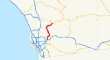
State Route 67 runs from Interstate 8 in El Cajon
to Lakeside
as the San Vicente Freeway. It then becomes a smaller roadway through Poway
and becomes Main Street in Ramona
before ending into State Route 78.
In 2004, it was planned that Route 67 would be upgraded to freeway grade a little bit farther up through Lakeside, but there are no plans yet to continue even further. In 1964, it was planned that SR 67 would be the eastern terminus of State Route 56, but local opposition from Poway to extend SR 56 through their city has essentially canceled this as well.
 This route is part of the California Freeway and Expressway System
. The route is named CHP Officer Christopher D. Lydon Memorial Freeway from Interstate 8
to Mapleview Street in Lakeside
.
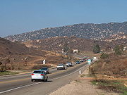
SR 67 begins at I-8 and turns to the north near the Westfield Parkway
shopping center in El Cajon
. The freeway leaves the El Cajon city limits, entering the city of Santee
near Gillespie Field
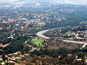
. Near the Woodside Avenue exit, SR 67 turns to the northeast, paralleling the San Diego River
and entering the unincorporated area of Eucalyptus Hills
. The freeway ends and SR 67 turns north into a conventional highway at Mapleview Street, crossing the San Diego River and entering Moreno. SR 67 enters the rural area east of Sycamore Canyon County Open Space Preserve, passing to the west of San Vicente Reservoir
. The road intersects the eastern end of Scripps Poway Parkway and CR S4, the latter within the Poway
city limits.
 In eastern Poway, SR 67 turns east, eventually leaving the city and entering unincorporated Rock Haven
. The road continues near Rosemont
before turning northeast and becoming Julian Road and then Main Street in downtown Ramona
. SR 67 ends at the intersection with SR 78; SR 78 intersects to the northwest as Pine Street and continues northeast along Main Street towards Julian
.
The entire route is in San Diego County
.
{| class=wikitable
!Location
!Postmile
!Exit
!Destinations
!Notes
|-
|rowspan=3|El Cajon
|R0.00
|
|Magnolia Avenue – El Cajon
|Continuation beyond I-8
|-
|R0.00
|1
|
|Signed as exits 1A (west) and 1B (east); no exit number northbound
|-
|R0.31
|1C
|Broadway, Fletcher Parkway
|No exit number northbound
|-
|
|R1.12
|1D
|Bradley Avenue
|Signed as exit 1 northbound
|-
|rowspan=3|Santee
|bgcolor=#ffdddd|R1.94
|bgcolor=#ffdddd|2
|bgcolor=#ffdddd|Prospect Avenue – Santee
|bgcolor=#ffdddd|Northbound exit and southbound entrance
|-
|
|2
|
|
|-bgcolor=#ffdddd
|R2.67
|3
|Woodside Avenue – Santee
|Southbound exit and northbound entrance
|-
|
|R3.91
|4
|Riverford Road
|
|-
|
|bgcolor=#ffdddd|R4.83
|bgcolor=#ffdddd|5
|bgcolor=#ffdddd|Winter Gardens Boulevard – Lakeside
|bgcolor=#ffdddd|Northbound exit and southbound entrance
|-
|colspan=5 align=center|North end of freeway
|-
|
|R5.48
|
|Mapleview Street – Lakeside Business District
|
|-
|
|bgcolor=#ffdddd|
|bgcolor=#ffdddd|
|bgcolor=#ffdddd|Vine Street
|bgcolor=#ffdddd|Interchange; northbound exit and entrance
|-
|
|13.56
|
|Scripps Poway Parkway, Rio Maria Road
|
|-
|Poway
|15.20
|
|
|
|-
|Ramona
|24.38
|
|
|
El Cajon, California
-History:El Cajon is located on the Rancho El Cajon Mexican land grant made in 1845 to María Antonia Estudillo, wife of Miguel Pedrorena. In 1876 Amaziah Lord Knox , a New Englander who had recently moved to California, established a hotel there to serve the growing number of people traveling...
to Lakeside
Lakeside, California
Lakeside is a Census Designated Place in San Diego County, California. The population was 20,648 at the 2010 census, up from 19,560 as of the 2000 census.- History :...
as the San Vicente Freeway. It then becomes a smaller roadway through Poway
Poway, California
Poway is a city in San Diego County, California. Originally an unincorporated community in San Diego County, Poway officially became a city in December 1980. Even though Poway lies geographically in the middle of San Diego County, most consider its relative location as north county inland...
and becomes Main Street in Ramona
Ramona, California
Ramona is a census-designated place in San Diego County, California. The population was 20,292 at the 2010 census.The term Ramona also refers to an unincorporated community that includes both the Ramona CDP and the adjacent CDP of San Diego Country Estates CDP...
before ending into State Route 78.
In 2004, it was planned that Route 67 would be upgraded to freeway grade a little bit farther up through Lakeside, but there are no plans yet to continue even further. In 1964, it was planned that SR 67 would be the eastern terminus of State Route 56, but local opposition from Poway to extend SR 56 through their city has essentially canceled this as well.
Route description
California Freeway and Expressway System
The California Freeway and Expressway System is a system of existing or planned freeways and expressways in the U.S. state of California. It is defined by the Streets and Highways Code.-List of roads in the system:*State Route 1 *State Route 2...
. The route is named CHP Officer Christopher D. Lydon Memorial Freeway from Interstate 8
Interstate 8
Interstate 8 is an Interstate Highway in the southwestern United States. It runs from the southern edge of Mission Bay at Sunset Cliffs Blvd, in San Diego, California, almost at the Pacific Ocean, to the junction with Interstate 10, just southeast of Casa Grande, Arizona...
to Mapleview Street in Lakeside
Lakeside, California
Lakeside is a Census Designated Place in San Diego County, California. The population was 20,648 at the 2010 census, up from 19,560 as of the 2000 census.- History :...
.
SR 67 begins at I-8 and turns to the north near the Westfield Parkway
Westfield Parkway
Westfield Parkway, formerly known as Parkway Plaza, is a shopping mall in El Cajon, California. It is owned and managed by the Westfield Group. Its anchor stores are JCPenney, Macy's, Sears, and Wal-Mart...
shopping center in El Cajon
El Cajon, California
-History:El Cajon is located on the Rancho El Cajon Mexican land grant made in 1845 to María Antonia Estudillo, wife of Miguel Pedrorena. In 1876 Amaziah Lord Knox , a New Englander who had recently moved to California, established a hotel there to serve the growing number of people traveling...
. The freeway leaves the El Cajon city limits, entering the city of Santee
Santee, California
Santee is a suburban city in San Diego County, California with a population of 53,413 at the 2010 census. Although it is a part of the East County region, Santee is located just from the Pacific Ocean. The city is connected to the coastline by State Route 52, a six-lane freeway that runs from...
near Gillespie Field
Gillespie Field
Gillespie Field is a county-owned public-use airport located 10 miles northeast of the central business district of San Diego, in El Cajon, San Diego County, California, United States....
. Near the Woodside Avenue exit, SR 67 turns to the northeast, paralleling the San Diego River
San Diego River
The San Diego River is a river in San Diego County, California. It originates in the Cuyamaca Mountains northwest of the town of Julian, then flows to the southwest until it reaches the El Capitan Reservoir, the largest reservoir in the river's watershed at . Below El Capitan Dam, the river runs...
and entering the unincorporated area of Eucalyptus Hills
Eucalyptus Hills, California
Eucalyptus Hills is a census-designated place in San Diego County, California. Eucalyptus Hills sits at an elevation of . The 2010 United States census reported Eucalyptus Hills's population was 5,313.-Geography:...
. The freeway ends and SR 67 turns north into a conventional highway at Mapleview Street, crossing the San Diego River and entering Moreno. SR 67 enters the rural area east of Sycamore Canyon County Open Space Preserve, passing to the west of San Vicente Reservoir
San Vicente Reservoir
San Vicente Reservoir is a reservoir created by the San Vicente Dam in the Cleveland National Forest of San Diego County, California, approximately 7 km north of Lakeside off of California State Route 67 in the Laguna Mountains.-Description:...
. The road intersects the eastern end of Scripps Poway Parkway and CR S4, the latter within the Poway
Poway, California
Poway is a city in San Diego County, California. Originally an unincorporated community in San Diego County, Poway officially became a city in December 1980. Even though Poway lies geographically in the middle of San Diego County, most consider its relative location as north county inland...
city limits.
Rock Haven, California
Rock Haven is an unincorporated community in Fresno County, California. It is located north of Shaver Lake Heights, at an elevation of 5774 feet ....
. The road continues near Rosemont
Rosemont, California
Rosemont is a census-designated place in Sacramento County, California, United States. It is part of the Sacramento–Arden-Arcade–Roseville Metropolitan Statistical Area...
before turning northeast and becoming Julian Road and then Main Street in downtown Ramona
Ramona, California
Ramona is a census-designated place in San Diego County, California. The population was 20,292 at the 2010 census.The term Ramona also refers to an unincorporated community that includes both the Ramona CDP and the adjacent CDP of San Diego Country Estates CDP...
. SR 67 ends at the intersection with SR 78; SR 78 intersects to the northwest as Pine Street and continues northeast along Main Street towards Julian
Julian, California
Julian is a census-designated place in San Diego County, California, in the United States. As of the 2010 census, the population was 1,502, down from 1,621 at the 2000 census.Julian is an official California Historical Landmark No. 412...
.
Major intersections
- Note: Except where prefixed with a letter, postmiles were measured in 1964, based on the alignment as it existed at that time, and do not necessarily reflect current mileage.
The entire route is in San Diego County
San Diego County, California
San Diego County is a large county located in the southwestern corner of the US state of California. Hence, San Diego County is also located in the southwestern corner of the 48 contiguous United States. Its county seat and largest city is San Diego. Its population was about 2,813,835 in the 2000...
.
{| class=wikitable
!Location
!Postmile
!Exit
Exit number
An exit number is a number assigned to a road junction, usually an exit from a freeway. It is usually marked on the same sign as the destinations of the exit, as well as a sign in the gore....
!Destinations
!Notes
|-
|rowspan=3|El Cajon
El Cajon, California
-History:El Cajon is located on the Rancho El Cajon Mexican land grant made in 1845 to María Antonia Estudillo, wife of Miguel Pedrorena. In 1876 Amaziah Lord Knox , a New Englander who had recently moved to California, established a hotel there to serve the growing number of people traveling...
|R0.00
|
|Magnolia Avenue – El Cajon
El Cajon, California
-History:El Cajon is located on the Rancho El Cajon Mexican land grant made in 1845 to María Antonia Estudillo, wife of Miguel Pedrorena. In 1876 Amaziah Lord Knox , a New Englander who had recently moved to California, established a hotel there to serve the growing number of people traveling...
|Continuation beyond I-8
|-
|R0.00
|1
|
|Signed as exits 1A (west) and 1B (east); no exit number northbound
|-
|R0.31
|1C
|Broadway, Fletcher Parkway
|No exit number northbound
|-
|
|R1.12
|1D
|Bradley Avenue
|Signed as exit 1 northbound
|-
|rowspan=3|Santee
Santee, California
Santee is a suburban city in San Diego County, California with a population of 53,413 at the 2010 census. Although it is a part of the East County region, Santee is located just from the Pacific Ocean. The city is connected to the coastline by State Route 52, a six-lane freeway that runs from...
|bgcolor=#ffdddd|R1.94
|bgcolor=#ffdddd|2
|bgcolor=#ffdddd|Prospect Avenue – Santee
Santee, California
Santee is a suburban city in San Diego County, California with a population of 53,413 at the 2010 census. Although it is a part of the East County region, Santee is located just from the Pacific Ocean. The city is connected to the coastline by State Route 52, a six-lane freeway that runs from...
|bgcolor=#ffdddd|Northbound exit and southbound entrance
|-
|
|2
|
|
|-bgcolor=#ffdddd
|R2.67
|3
|Woodside Avenue – Santee
Santee, California
Santee is a suburban city in San Diego County, California with a population of 53,413 at the 2010 census. Although it is a part of the East County region, Santee is located just from the Pacific Ocean. The city is connected to the coastline by State Route 52, a six-lane freeway that runs from...
|Southbound exit and northbound entrance
|-
|
|R3.91
|4
|Riverford Road
|
|-
|
|bgcolor=#ffdddd|R4.83
|bgcolor=#ffdddd|5
|bgcolor=#ffdddd|Winter Gardens Boulevard – Lakeside
Lakeside, California
Lakeside is a Census Designated Place in San Diego County, California. The population was 20,648 at the 2010 census, up from 19,560 as of the 2000 census.- History :...
|bgcolor=#ffdddd|Northbound exit and southbound entrance
|-
|colspan=5 align=center|North end of freeway
|-
|
|R5.48
|
|Mapleview Street – Lakeside Business District
|
|-
|
|bgcolor=#ffdddd|
|bgcolor=#ffdddd|
|bgcolor=#ffdddd|Vine Street
|bgcolor=#ffdddd|Interchange; northbound exit and entrance
|-
|
|13.56
|
|Scripps Poway Parkway, Rio Maria Road
|
|-
|Poway
Poway, California
Poway is a city in San Diego County, California. Originally an unincorporated community in San Diego County, Poway officially became a city in December 1980. Even though Poway lies geographically in the middle of San Diego County, most consider its relative location as north county inland...
|15.20
|
|
|
|-
|Ramona
Ramona, California
Ramona is a census-designated place in San Diego County, California. The population was 20,292 at the 2010 census.The term Ramona also refers to an unincorporated community that includes both the Ramona CDP and the adjacent CDP of San Diego Country Estates CDP...
|24.38
|
|
|