
California State Route 76
Encyclopedia
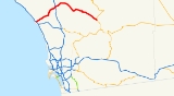
State Route 76 is a 52.32 miles (84.2 km) state highway
in the U.S. state
of California
. It is an important east–west route in the North County region of San Diego County
that begins in Oceanside
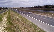
near Interstate 5 and continues east past Interstate 15 to State Route 79. The section of the highway through Oceanside is an expressway; east of Oceanside, SR 76 is a two-lane highway, although there are plans for the expansion of much of the route.
, although only the section through Oceanside is an expressway. SR 76 is eligible for the State Scenic Highway System
, but it is not officially designated as a scenic highway by the California Department of Transportation
. The expressway part of this highway is also named for Tony Zeppetella, an Oceanside police officer killed in the line of duty.
State Route 76 begins at County Route S21 in Oceanside
, the former routing of U.S. Route 101. It quickly has an interchange with Interstate 5, then becomes a four-lane expressway known as the San Luis Rey Mission Expressway. From I-5 to Mission Avenue, SR 76 parallels the San Luis Rey River
until it passes by Oceanside Municipal Airport
. During this stretch, SR 76 intersects Loretta Street, Canyon Drive, Benet Road, Airport Road, and Foussat Road. It then has an overpass over Mission Avenue and El Camino Real before intersecting Douglas Drive, the main road to the San Luis Rey gate of Camp Pendleton. After an intersection with Rancho Del Oro Road, SR 76 passes over Mission Avenue again before intersecting with Old Grove Road, Frazee Road, a turnoff into the Towne Center North shopping center, and College Boulevard.
As it begins to enter rural Oceanside, SR 76 intersects with County Route S14 (South Santa Fe Avenue) a main road that travels into Vista, Guajome Lake Road (with access to Guajome County Park), and Melrose Drive. From Melrose Drive to Jeffries Ranch Road, the expressway narrows to two lanes. East of Jefferies Ranch Road, SR 76 remains a two-lane highway for the remainder of its route. However, construction is underway for the widening and alignment east from Jefferies Ranch Road to Olive Hill Road in Bonsall. This segment is scheduled to be complete by 2014, with widening to Interstate 15 scheduled to start by 2020.
SR 76 intersects the southern segment of County Route S13 (East Vista Way) which also goes into Vista, and passes over the San Luis Rey River before going through Bonsall and intersecting Olive Hill Road. SR 76 then meets the northern segment of CR S13 (South Mission Road), heading north into Fallbrook
; SR 76 is the primary road connecting the two halves of CR S13, but this portion of CR S13's routing is not signed. It is at this point when SR 76 becomes known as Pala Road. It intersects Gird Road south of Fallbrook before encountering the former routing of U.S. Route 395 and the current routing of Interstate 15 in the community of Pala Mesa Village.
SR 76 then goes through Pala
and the Pala Indian Reservation
, passing by Pala Casino and intersecting County Route S16, the turnoff to the Pala Mission and Temecula
. Continuing to parallel the San Luis Rey River, SR 76 passes by the Wilderness Gardens County Park before entering the community of Pauma Valley
and meeting the southern terminus of CR S7 (Nate Harrison Grade), a dirt road leading into Palomar Mountain State Park
. SR 76 intersects with the southern leg of County Route S6 (Valley Center Road), the turnoff to Valley Center
and Escondido
before passing through the small Yuima Indian Reservation. SR 76 then intersects with the northern leg of CR S6, the southern approach to the Palomar Observatory
and Palomar Mountain State Park before passing through La Jolla Amago. It then briefly passes through the Cleveland National Forest
before meeting the eastern terminus of County Route S7, which is the eastern approach to Palomar Mountain. Sr 76 then passes along the shores of Lake Henshaw before terminating at the intersection with State Route 79 at Morettis Junction, southeast of Lake Henshaw.
During the 1964 state highway renumbering
, Legislative Route 195 was legally designated as State Route 76. The legal designation was updated to reflect the new construction of Interstate 5.
Before 1994 all of SR 76 was a two-lane highway, running on Mission Avenue in Oceanside. A four lane expressway bypass of Oceanside was constructed beginning in 1994. The first four miles (from Interstate 5 to Mission Avenue east of Foussat Road) opened to traffic in 1996. The next stretch (from Mission Avenue to College Blvd.) opened in early 1999. The final stretch between College Blvd. and Jefferies Ranch Road was opened in late 1999. Because the expressway was constructed on top of Mission Avenue east of Old Grove Road, Mission Avenue was rerouted onto a new alignment that connected to Frazee Road. However, Mission Avenue is still fragmented today, and does not exist between Frazee Road and Jefferies Ranch Road, where the expressway ends.
 There are plans to extend the expressway all the way to I-15. In March 2009, a new 1.3 mile realigned segment of State Route 76 opened east of I-15. Initially, only two lanes are open, with the other two lanes of this new four lane divided highway planned to open in September 2009. The purpose of this improvement is to reduce accidents on a stretch of road that now carries over 12,000 motorists per day. Much of this traffic is destined for either the Pala Indian casino or a new gravel quarry that was recently opened. The casino and quarry owners each paid for half of the new road. At this time, there are no plans to extend this improvement eastward to Pala.
The city of Oceanside does have plans for grade-separated interchanges with College Boulevard and Melrose Drive, should the expressway through Oceanside need to be converted to a freeway.
The entire route is in San Diego County
.
{| class=wikitable
!Location
!Postmile
!Destinations
!Notes
|-
|rowspan=5|Oceanside
|R0.00
|
|Continuation beyond I-5
|-
|R0.00
|
|Interchange
|-
|R3.75
|Douglas Drive
|
|-
|R6.21
|College Boulevard
|
|-
|R6.72
|
|
|-
|rowspan=2|Bonsall
|bgcolor=#ddffdd|R9.49
|bgcolor=#ddffdd|
|bgcolor=#ddffdd|West end of CR S13 overlap
|-bgcolor=#ddffdd
|12.47
|
|East end of CR S13 overlap
|-
|
|R17.02
|Old Highway 395
|Former US 395
|-
|
|R17.30
|
|Interchange
|-
|Pala
|24.13
|
|
|-
|Rincon
|bgcolor=#ddffdd|32.87
|bgcolor=#ddffdd|
|bgcolor=#ddffdd|West end of CR S6 overlap
|-
|
|bgcolor=#ddffdd|38.25
|bgcolor=#ddffdd|
|bgcolor=#ddffdd|East end of CR S6 overlap
|-
|
|47.79
|
|
|-
|Morettis Junction
|52.32
|
|
State highway
State highway, state road or state route can refer to one of three related concepts, two of them related to a state or provincial government in a country that is divided into states or provinces :#A...
in the U.S. state
U.S. state
A U.S. state is any one of the 50 federated states of the United States of America that share sovereignty with the federal government. Because of this shared sovereignty, an American is a citizen both of the federal entity and of his or her state of domicile. Four states use the official title of...
of California
California
California is a state located on the West Coast of the United States. It is by far the most populous U.S. state, and the third-largest by land area...
. It is an important east–west route in the North County region of San Diego County
San Diego County, California
San Diego County is a large county located in the southwestern corner of the US state of California. Hence, San Diego County is also located in the southwestern corner of the 48 contiguous United States. Its county seat and largest city is San Diego. Its population was about 2,813,835 in the 2000...
that begins in Oceanside
Oceanside, California
-2010:The 2010 United States Census reported that Oceanside had a population of 167,086. The population density was 3,961.8 people per square mile...
near Interstate 5 and continues east past Interstate 15 to State Route 79. The section of the highway through Oceanside is an expressway; east of Oceanside, SR 76 is a two-lane highway, although there are plans for the expansion of much of the route.
Route description
From Interstate 5 to Interstate 15, SR 76 is part of the California Freeway and Expressway SystemCalifornia Freeway and Expressway System
The California Freeway and Expressway System is a system of existing or planned freeways and expressways in the U.S. state of California. It is defined by the Streets and Highways Code.-List of roads in the system:*State Route 1 *State Route 2...
, although only the section through Oceanside is an expressway. SR 76 is eligible for the State Scenic Highway System
State Scenic Highway System (California)
The State Scenic Highway System is a list of highways, mainly state highways, that have been designated by the California Department of Transportation as scenic highways. The California State Legislature, primarily through Section 263 of the Streets and Highways Code, makes highways eligible for...
, but it is not officially designated as a scenic highway by the California Department of Transportation
California Department of Transportation
The California Department of Transportation is a government department in the U.S. state of California. Its mission is to improve mobility across the state. It manages the state highway system and is actively involved with public transportation systems throughout the state...
. The expressway part of this highway is also named for Tony Zeppetella, an Oceanside police officer killed in the line of duty.
State Route 76 begins at County Route S21 in Oceanside
Oceanside, California
-2010:The 2010 United States Census reported that Oceanside had a population of 167,086. The population density was 3,961.8 people per square mile...
, the former routing of U.S. Route 101. It quickly has an interchange with Interstate 5, then becomes a four-lane expressway known as the San Luis Rey Mission Expressway. From I-5 to Mission Avenue, SR 76 parallels the San Luis Rey River
San Luis Rey River
The San Luis Rey River is a river in northern San Diego County, California. The river's headwaters are in the Cleveland National Forest near Palomar Mountain. The river drains into the Pacific Ocean on the northern end of the city of Oceanside. The river is over long and drains...
until it passes by Oceanside Municipal Airport
Oceanside Municipal Airport
Oceanside Municipal Airport is a public airport located two miles northeast of the central business district of Oceanside, a city in San Diego County, California. The airport covers and has one runway. It is mostly used for general aviation....
. During this stretch, SR 76 intersects Loretta Street, Canyon Drive, Benet Road, Airport Road, and Foussat Road. It then has an overpass over Mission Avenue and El Camino Real before intersecting Douglas Drive, the main road to the San Luis Rey gate of Camp Pendleton. After an intersection with Rancho Del Oro Road, SR 76 passes over Mission Avenue again before intersecting with Old Grove Road, Frazee Road, a turnoff into the Towne Center North shopping center, and College Boulevard.
As it begins to enter rural Oceanside, SR 76 intersects with County Route S14 (South Santa Fe Avenue) a main road that travels into Vista, Guajome Lake Road (with access to Guajome County Park), and Melrose Drive. From Melrose Drive to Jeffries Ranch Road, the expressway narrows to two lanes. East of Jefferies Ranch Road, SR 76 remains a two-lane highway for the remainder of its route. However, construction is underway for the widening and alignment east from Jefferies Ranch Road to Olive Hill Road in Bonsall. This segment is scheduled to be complete by 2014, with widening to Interstate 15 scheduled to start by 2020.
SR 76 intersects the southern segment of County Route S13 (East Vista Way) which also goes into Vista, and passes over the San Luis Rey River before going through Bonsall and intersecting Olive Hill Road. SR 76 then meets the northern segment of CR S13 (South Mission Road), heading north into Fallbrook
Fallbrook, California
Fallbrook is an unincorporated community in northern San Diego County, California. The Fallbrook census-designated place population was 30,534 at the 2010 census, up from 29,100 at the 2000 census....
; SR 76 is the primary road connecting the two halves of CR S13, but this portion of CR S13's routing is not signed. It is at this point when SR 76 becomes known as Pala Road. It intersects Gird Road south of Fallbrook before encountering the former routing of U.S. Route 395 and the current routing of Interstate 15 in the community of Pala Mesa Village.
SR 76 then goes through Pala
Pala, California
Pala is a small, mostly Native American, community located in San Diego County, California near Fallbrook. It is east of Carlsbad in the San Diego-Carlsbad metro area. In the National Geographic Names Database it is officially catalogued as feature number 1661174...
and the Pala Indian Reservation
Pala Indian Reservation
The Pala Indian Reservation is located in the middle San Luis Rey River Valley in northern San Diego County, California, east of the community of Fallbrook, and has been assigned feature ID 272502. Historic variant names used to describe the area include Mission Indian Reservation and Mission...
, passing by Pala Casino and intersecting County Route S16, the turnoff to the Pala Mission and Temecula
Temecula, California
Temecula is a city in southwestern Riverside County, California, United States with a population of 100,097 according to the 2010 United States Census, making it the lowest populated American city over 100,000 population. It was incorporated on December 1, 1989...
. Continuing to parallel the San Luis Rey River, SR 76 passes by the Wilderness Gardens County Park before entering the community of Pauma Valley
Pauma Valley, California
Pauma Valley is an unincorporated community between Valley Center and Palomar Mountain in San Diego County, California. The name also refers to an agricultural region comprising citrus and avocado groves, several Indian Reservations, casinos, and a country club.The headquarters of the La Jolla...
and meeting the southern terminus of CR S7 (Nate Harrison Grade), a dirt road leading into Palomar Mountain State Park
Palomar Mountain
Palomar Mountain is a mountain in the Peninsular Ranges in northern San Diego County. It is famous as the location of the Palomar Observatory and Hale Telescope, and known for the Palomar Mountain State Park.-History:...
. SR 76 intersects with the southern leg of County Route S6 (Valley Center Road), the turnoff to Valley Center
Valley Center, California
Valley Center is a census-designated place in San Diego County, California. The population was 9,277 at the 2010 census, up from 7,323 at the 2000 census.-Geography:Valley Center is located at ....
and Escondido
Escondido, California
Escondido is a city occupying a shallow valley ringed by rocky hills, just north of the city of San Diego, California. Founded in 1888, it is one of the oldest cities in San Diego County. The city had a population of 143,911 at the 2010 census. Its municipal government set itself an operating...
before passing through the small Yuima Indian Reservation. SR 76 then intersects with the northern leg of CR S6, the southern approach to the Palomar Observatory
Palomar Observatory
Palomar Observatory is a privately owned observatory located in San Diego County, California, southeast of Pasadena's Mount Wilson Observatory, in the Palomar Mountain Range. At approximately elevation, it is owned and operated by the California Institute of Technology...
and Palomar Mountain State Park before passing through La Jolla Amago. It then briefly passes through the Cleveland National Forest
Cleveland National Forest
Cleveland National Forest encompasses 460,000 acres , mostly of chaparral, with a few riparian areas. A warm dry mediterranean climate prevails over the Forest. It is the southernmost National forest of California. It is administered by the United States Forest Service, a government agency within...
before meeting the eastern terminus of County Route S7, which is the eastern approach to Palomar Mountain. Sr 76 then passes along the shores of Lake Henshaw before terminating at the intersection with State Route 79 at Morettis Junction, southeast of Lake Henshaw.
History
SR 76 was originally designated as a state highway, and extended from U.S. 101 in Oceanside all the way to SR 79 near Lake Henshaw. The road was constructed by 1930, although it was not paved east of Pala. However, it was not designated as Legislative Route 195 until 1935. SR 76 was fully signed by 1956.During the 1964 state highway renumbering
1964 state highway renumbering (California)
In 1963 and 1964, the California Division of Highways implemented a major renumbering of its state highways. The majority of sign routes — those marked for the public — kept their numbers; the main changes were to the legislative routes, which had their numbers changed to match the sign routes...
, Legislative Route 195 was legally designated as State Route 76. The legal designation was updated to reflect the new construction of Interstate 5.
Before 1994 all of SR 76 was a two-lane highway, running on Mission Avenue in Oceanside. A four lane expressway bypass of Oceanside was constructed beginning in 1994. The first four miles (from Interstate 5 to Mission Avenue east of Foussat Road) opened to traffic in 1996. The next stretch (from Mission Avenue to College Blvd.) opened in early 1999. The final stretch between College Blvd. and Jefferies Ranch Road was opened in late 1999. Because the expressway was constructed on top of Mission Avenue east of Old Grove Road, Mission Avenue was rerouted onto a new alignment that connected to Frazee Road. However, Mission Avenue is still fragmented today, and does not exist between Frazee Road and Jefferies Ranch Road, where the expressway ends.
Future
The city of Oceanside does have plans for grade-separated interchanges with College Boulevard and Melrose Drive, should the expressway through Oceanside need to be converted to a freeway.
Major intersections
- Note: Except where prefixed with a letter, postmiles were measured in 1964, based on the alignment as it existed at that time, and do not necessarily reflect current mileage.
The entire route is in San Diego County
San Diego County, California
San Diego County is a large county located in the southwestern corner of the US state of California. Hence, San Diego County is also located in the southwestern corner of the 48 contiguous United States. Its county seat and largest city is San Diego. Its population was about 2,813,835 in the 2000...
.
{| class=wikitable
!Location
!Postmile
!Destinations
!Notes
|-
|rowspan=5|Oceanside
Oceanside, California
-2010:The 2010 United States Census reported that Oceanside had a population of 167,086. The population density was 3,961.8 people per square mile...
|R0.00
|
|Continuation beyond I-5
|-
|R0.00
|
|Interchange
|-
|R3.75
|Douglas Drive
|
|-
|R6.21
|College Boulevard
|
|-
|R6.72
|
|
|-
|rowspan=2|Bonsall
Bonsall, California
Bonsall is a census-designated place in San Diego County, California. The population was 3,982 at the 2010 census, up from 3,401 at the 2000 census.-Geography:Bonsall is located just east of Oceanside and Camp Pendleton....
|bgcolor=#ddffdd|R9.49
|bgcolor=#ddffdd|
|bgcolor=#ddffdd|West end of CR S13 overlap
|-bgcolor=#ddffdd
|12.47
|
|East end of CR S13 overlap
|-
|
|R17.02
|Old Highway 395
|Former US 395
U.S. Route 395 in California
In the U.S. state of California, U.S. Route 395 is a route which traverses from Interstate 15 near the southern city limits of Hesperia, north to the Oregon state line in Modoc County near Goose Lake...
|-
|
|R17.30
|
|Interchange
|-
|Pala
Pala, California
Pala is a small, mostly Native American, community located in San Diego County, California near Fallbrook. It is east of Carlsbad in the San Diego-Carlsbad metro area. In the National Geographic Names Database it is officially catalogued as feature number 1661174...
|24.13
|
|
|-
|Rincon
Rincon, California
Rincon is an unincorporated community in San Diego County, California. Its elevation is 1030 feet above sea level. Its coordinates are 33 degrees north, 117 degrees west, and its ZIP code is 92061....
|bgcolor=#ddffdd|32.87
|bgcolor=#ddffdd|
|bgcolor=#ddffdd|West end of CR S6 overlap
|-
|
|bgcolor=#ddffdd|38.25
|bgcolor=#ddffdd|
|bgcolor=#ddffdd|East end of CR S6 overlap
|-
|
|47.79
|
|
|-
|Morettis Junction
|52.32
|
|