
Bootheel
Encyclopedia
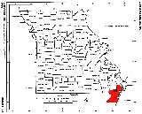
The Missouri Bootheel is the southeasternmost part of the state of Missouri
, extending south of 36°30’ north latitude
, so called because its shape in relation to the rest of the state resembles the heel of a boot. Strictly speaking, it is composed of the counties of Dunklin
, New Madrid
, and Pemiscot
. However, the term is sometimes used to refer to the entire southeastern lowlands of Missouri located within the Mississippi Embayment
, which includes parts of Butler
, Mississippi
, Ripley
, Scott
, Stoddard
and extreme southern portions of Cape Girardeau
and Bollinger
counties. The largest cities in the region are Sikeston
and Kennett
.
The Bootheel along with the Oklahoma
-Kansas
-Missouri
border near the 37th parallel north
form the two biggest jogs in a nearly straight line of state borders that starts on the Atlantic Ocean
with the Virginia
–North Carolina
border extending all the way to the tristate border of Nevada
, Arizona
and Utah
.
and Tennessee
, which would have excluded the Bootheel. However, John Hardeman Walker
, a pioneer planter in what is now Pemiscot County, argued that the area had more in common with the Mississippi River towns of Cape Girardeau
, Ste. Genevieve
and St. Louis
in Missouri than with its proposed incorporation in Arkansas Territory
. The border was dropped about 50 miles to the 36th parallel north
. It follows that parallel about 30 miles until intersecting the St. Francis River, then follows the river back up to about the 36°30′ parallel just west of Campbell, Missouri
.
According to an apocryphal story in various versions, the bootheel was added because of the request of some Missourian to remain in the state "as he had heard it was so sickly in Arkansas;" ""...full of bears and panthers and copperhead snakes, so it ain't safe for civilized people to stay there over night even." Another folktale has the adaptation made by a lovestruck surveyor to spare the feelings of a widow living fifty miles south of the Missouri border, but unaware of it. At one time, the area was known locally as "Lapland, because it's the place where Missouri laps over into Arkansas".
(more than 1.8 mya) to Quaternary
(1.8 mya to present) geology, much younger than neighboring highlands. The lowest point in the state is in southwestern Dunklin County along the St. Francis River
near Arbyrd, Missouri
, at 230 feet above sea level. The bootheel area is notable for being the epicenter of the 1811-1812 New Madrid Earthquakes, some of the largest earthquakes ever felt in the United States.
and St. Francis rivers; the land is very flat and is now used for predominantly agricultural
purposes. Prior to the 20th century, it was mostly swamp
y forestland not settled by European Americans. As glaciers receded towards the end of the Ice Age
and turned ice into liquid, the Mississippi River grew longer and wider. Over time, the silt deposits of the Mississippi created some of the most fertile soil in the world, ideal for agriculture. The areas around the Mississippi are composed of thick regolith that is around 100 metres (328.1 ft) thick.
Between 1893 and 1989, developers cut about 85% of the native forests. The entire landscape was transformed into farmland by extensive logging, draining of the watershed
, channelization, and the construction of flood control
structures. High levees along both river courses, an extensive system of drainage ditches and diversion channels, and controlled lakes, pumping stations and cutoffs protect the area from flooding. The soils are predominantly a rich and deep glacial loess
, alluvial silt
, and a sandy loam
, well-suited for agricultural use. The levees have changed the nature of the rivers, however, and in some cases aggravated flooding problems. They also prevent regular silt deposits, as they have increased the speed of the rivers. The reduction in wetlands has reduced important habitats for many species of migratory birds and a variety of fish and animals.
Flooding is a major concern along the Mississippi River. With such a large river basin and the vast discharge of water, the river makes the towns along its banks highly susceptible to frequent flooding. The National Weather Service
reported that from 1980 to 2002, nine floods in the United States had total losses exceeding one billion dollars. In terms of monetary loss and impact on society, the Great Flood of 1993
was the worst.
is named for the town of New Madrid
in the Bootheel. This fault zone is entirely hidden beneath the deep alluvial deposits of the Mississippi embayment
and, unlike the San Andreas Fault
in California
, is not visible anywhere. This fault zone was responsible for an extremely powerful series of earthquake
s that rocked the area in 1811 and 1812, known collectively as the New Madrid Earthquake
, which reportedly rang church bells along the East Coast
. Subsidence
formed Reelfoot Lake
across the Mississippi River in West Tennessee
. An eyewitness of the earthquakes of 1811 and 1812 noted,
The states of Missouri, Arkansas, Mississippi, Alabama, Tennessee, Kentucky, Illinois, and Indiana felt the brunt of this quake, ruining lives and leaving residents in fear of aftershocks and possible larger quakes. To this day, the New Madrid Seismic Zone is still active and produces small earthquakes very frequently. Scientists have estimated that a strong earthquake is inevitable to happen again and is overdue. Residents of the area are aware of the risk, but critics say they are not well prepared for a disaster. William Atkinson, author of The Next New Madrid Earthquake, writes,
culture that produced the Delta blues
. Its relatively large black
population makes it distinct from the rest of rural
Missouri, and the area has a unique rural black culture reflected in its music, churches and other traditions. The Black
population ranges from about 26% in Pemiscot County, to 15% in New Madrid County and about 9% in Dunklin County.
The Bootheel once had a reputation for lawlessness. Remote settlements along the river banks, miles from paved roads, provided an ideal environment (and market) for moonshining
and bootlegging
.
Culturally, the Bootheel is considered more Southern
than Midwestern
. It is part of the Mid-South
, a region focused on the Memphis metropolitan area
. Definitions of the Mid-South vary but in general include west Tennessee
, north Mississippi
, northeast Arkansas
, and the Missouri Bootheel. The locations of the region's television stations reflect this:
The farther south in the Bootheel, the more pronounced is residents' identification with the South. The network television affiliates in Memphis, Tennessee
, which is the largest city for 200 miles, or in Jonesboro, Arkansas
, often have a greater audience than those in Illinois, Kentucky, or Cape Girardeau.
Economically, the area is one of the more impoverished
parts of Missouri and does not enjoy the benefits of tourism in the nearby Ozark Mountains. There is some manufacturing, but the area is primarily agricultural. Because of its alluvial past, the area's rich soil is ideal for growing soybeans, rice
and cotton
. Some "truck crops" are grown, most notably various types of melons, especially watermelon
s. A limited amount of livestock is raised, and in contrast to much of the rest of Missouri, there are very few fence
s.
No large cities are located in the Bootheel. Sizable towns include Kennett
(the birthplace of singers Sheryl Crow
, Trent Tomlinson
, and David Nail
) and Sikeston
(the birthplace of professional athletes James Wilder
, Brandon Barnes
, and Blake DeWitt
), which is partially in Scott County
and New Madrid County. Cape Girardeau and Poplar Bluff
are often grouped together with the bootheel due to the influence the two cities have had on the development of the region, despite not being in the physical area of the bootheel.
Hornersville
, a small town in southern Dunklin County, was home to William H. "Major" Ray
, a one-time 19th-century circus "midget
". He later became known as the representative of the Buster Brown
shoe brand
. He and his wife, Jennie, are buried in a cemetery in Hornersville.
The small towns of Senath and Arbyrd are also located in Dunklin County. They are home to a locally celebrated ghost light
, sometimes called the "Senath Light" or "Arbyrd light". It occurs between these two towns and closer to Hollywood
near the Lulu Church and Cemetery.
The Missouri Bootheel is the home place of two members of the musical group the Kentucky Headhunters, Doug and Ricky Phelps. They received their education at Southland C-9, the consolidated schools of Arbyrd and Cardwell, Missouri
. They performed at the Cotton Pickin Festival in the small town of Arbyrd; a place where they spent much time while growing up. They both performed as Brother Phelps
, and then Doug came back and performed with The Kentucky Headhunters
. This festival is a major attraction and draws a huge crowd for a town of only about 550 people. Other prominent acts at Arbyrd include T. Graham Brown
and the Bellamy Brothers
.
Also in the northern part of Dunklin County lies the town of Malden, the home of country/rockabilly singer Narvel Felts
. Felts' music has played worldwide, as he continues to tour. George (Richardson) Richey is a well-known country music producer. Richey was married to Tammy Wynette
. Tammy came to claim Malden as her own and appeared annually at the Fourth of July celebrations for years.
During the American Civil War
, a number of battles took place in this area, most notably the Battle of Island No. 10.
Missouri
Missouri is a US state located in the Midwestern United States, bordered by Iowa, Illinois, Kentucky, Tennessee, Arkansas, Oklahoma, Kansas and Nebraska. With a 2010 population of 5,988,927, Missouri is the 18th most populous state in the nation and the fifth most populous in the Midwest. It...
, extending south of 36°30’ north latitude
Latitude
In geography, the latitude of a location on the Earth is the angular distance of that location south or north of the Equator. The latitude is an angle, and is usually measured in degrees . The equator has a latitude of 0°, the North pole has a latitude of 90° north , and the South pole has a...
, so called because its shape in relation to the rest of the state resembles the heel of a boot. Strictly speaking, it is composed of the counties of Dunklin
Dunklin County, Missouri
Dunklin County is a county located in the Bootheel of Southeast Missouri in the United States. As of the 2000 U.S. Census, the county's population was 33,155. A 2008 estimate, however, showed the population to be 31,454. The largest city and county seat is Kennett...
, New Madrid
New Madrid County, Missouri
New Madrid County is a county located in the Bootheel of southeast Missouri in the United States. As of the 2000 Census, the county's population was 19,760. A 2008 estimate, however, showed the population to be 17,589. The largest city and county seat is New Madrid...
, and Pemiscot
Pemiscot County, Missouri
Pemiscot County is a county located in the Bootheel in Southeast Missouri in the United States. As of the 2000 U.S. Census, the county's population was 20,047. A 2008 estimate, however, showed the population to be 18,515. The largest city and county seat is Caruthersville...
. However, the term is sometimes used to refer to the entire southeastern lowlands of Missouri located within the Mississippi Embayment
Mississippi embayment
The Mississippi Embayment is a physiographic feature in the south-central United States, part of the Mississippi Alluvial Plain. It is essentially a northward continuation of the fluvial sediments of the Mississippi River Delta to its confluence with the Ohio River at Cairo, Illinois. The embayment...
, which includes parts of Butler
Butler County, Missouri
Butler County is a county located in the southeast Ozark Foothills Region in Southeast Missouri in the United States. As of the 2010 U.S. Census, the county's population was 42,794. The largest city and county seat is Poplar Bluff. The county was officially organized from Wayne County on February...
, Mississippi
Mississippi County, Missouri
Mississippi County is a county located in the Bootheel of Southeast Missouri in the United States. As of the 2000 U.S. Census, the county's population was 13,427. A 2008 estimate, however, showed the population to be 13,504. The largest city and county seat is Charleston...
, Ripley
Ripley County, Missouri
Ripley County is a county located in the Ozarks of Southeast Missouri in the United States. As of the 2000 U.S. Census, the county's population was 13,509. A 2008 estimate, however, showed the population to be 13,485. The largest city and county seat is Doniphan...
, Scott
Scott County, Missouri
Scott County is a county located in Southeast Missouri in the United States. As of the 2000 U.S. Census, the population was 40,422; a 2008 estimate, however, showed the population to be 40,673. Its county seat is Benton...
, Stoddard
Stoddard County, Missouri
Stoddard County is a county located in Southeast Missouri in the United States. As of the 2000 U.S. Census, the population was 29,705. A 2008 estimate, however, showed the population to be 29,537. The county seat is Bloomfield while the largest city in the county is Dexter...
and extreme southern portions of Cape Girardeau
Cape Girardeau County, Missouri
Cape Girardeau County is a county located in Southeast Missouri in the United States. As of the 2010 U.S. Census, the county's population was 75,764. While the largest city in the county is Cape Girardeau, the county seat is actually Jackson, which was the first city named in honor of President...
and Bollinger
Bollinger County, Missouri
Bollinger County is a county located in Southeast Missouri in the United States. As of the 2010 U.S. Census, the county's population was 12,363; despite a 2009 estimate that showed the population to be 11,841. The county seat is Marble Hill, which is the only city in Bollinger County...
counties. The largest cities in the region are Sikeston
Sikeston, Missouri
Sikeston is a city located both in southern Scott County and northern New Madrid County, in the U.S. state of Missouri. It is geographically situated just north of the "Missouri Bootheel", although many locals consider Sikeston a part of it. By way of Interstate 55, Sikeston is close to the...
and Kennett
Kennett, Missouri
Kennett is a city in Dunklin County, Missouri, United States. The population was 11,260 at the 2000 census, but a 2008 estimate indicates a 4.9% decrease in population to 10,707. Kennett is the county seat of Dunklin County...
.
The Bootheel along with the Oklahoma
Oklahoma
Oklahoma is a state located in the South Central region of the United States of America. With an estimated 3,751,351 residents as of the 2010 census and a land area of 68,667 square miles , Oklahoma is the 28th most populous and 20th-largest state...
-Kansas
Kansas
Kansas is a US state located in the Midwestern United States. It is named after the Kansas River which flows through it, which in turn was named after the Kansa Native American tribe, which inhabited the area. The tribe's name is often said to mean "people of the wind" or "people of the south...
-Missouri
Missouri
Missouri is a US state located in the Midwestern United States, bordered by Iowa, Illinois, Kentucky, Tennessee, Arkansas, Oklahoma, Kansas and Nebraska. With a 2010 population of 5,988,927, Missouri is the 18th most populous state in the nation and the fifth most populous in the Midwest. It...
border near the 37th parallel north
37th parallel north
The 37th parallel north is a circle of latitude that is 37 degrees north of the Earth's equatorial plane. It crosses Europe, the Mediterranean Sea, Africa, Asia, the Pacific Ocean, North America, and the Atlantic Ocean....
form the two biggest jogs in a nearly straight line of state borders that starts on the Atlantic Ocean
Atlantic Ocean
The Atlantic Ocean is the second-largest of the world's oceanic divisions. With a total area of about , it covers approximately 20% of the Earth's surface and about 26% of its water surface area...
with the Virginia
Virginia
The Commonwealth of Virginia , is a U.S. state on the Atlantic Coast of the Southern United States. Virginia is nicknamed the "Old Dominion" and sometimes the "Mother of Presidents" after the eight U.S. presidents born there...
–North Carolina
North Carolina
North Carolina is a state located in the southeastern United States. The state borders South Carolina and Georgia to the south, Tennessee to the west and Virginia to the north. North Carolina contains 100 counties. Its capital is Raleigh, and its largest city is Charlotte...
border extending all the way to the tristate border of Nevada
Nevada
Nevada is a state in the western, mountain west, and southwestern regions of the United States. With an area of and a population of about 2.7 million, it is the 7th-largest and 35th-most populous state. Over two-thirds of Nevada's people live in the Las Vegas metropolitan area, which contains its...
, Arizona
Arizona
Arizona ; is a state located in the southwestern region of the United States. It is also part of the western United States and the mountain west. The capital and largest city is Phoenix...
and Utah
Utah
Utah is a state in the Western United States. It was the 45th state to join the Union, on January 4, 1896. Approximately 80% of Utah's 2,763,885 people live along the Wasatch Front, centering on Salt Lake City. This leaves vast expanses of the state nearly uninhabited, making the population the...
.
History
When Missouri was added to the Union, its original border proposal was to be an extension of the 36°30′ parallel north that formed the border between KentuckyKentucky
The Commonwealth of Kentucky is a state located in the East Central United States of America. As classified by the United States Census Bureau, Kentucky is a Southern state, more specifically in the East South Central region. Kentucky is one of four U.S. states constituted as a commonwealth...
and Tennessee
Tennessee
Tennessee is a U.S. state located in the Southeastern United States. It has a population of 6,346,105, making it the nation's 17th-largest state by population, and covers , making it the 36th-largest by total land area...
, which would have excluded the Bootheel. However, John Hardeman Walker
John Hardeman Walker
John Hardeman Walker was an early landowner in southeast Missouri, most famous for convincing the United States Congress to place the Bootheel in Missouri instead of Arkansas....
, a pioneer planter in what is now Pemiscot County, argued that the area had more in common with the Mississippi River towns of Cape Girardeau
Cape Girardeau, Missouri
Cape Girardeau is a city located in Cape Girardeau and Scott counties in Southeast Missouri in the United States. It is located approximately southeast of St. Louis and north of Memphis. As of the 2010 census, the city's population was 37,941. A college town, it is the home of Southeast Missouri...
, Ste. Genevieve
Ste. Genevieve, Missouri
Ste. Genevieve is a city in and the county seat of Ste. Genevieve County, Missouri, United States. The population was 11,654 at the 2000 census...
and St. Louis
St. Louis, Missouri
St. Louis is an independent city on the eastern border of Missouri, United States. With a population of 319,294, it was the 58th-largest U.S. city at the 2010 U.S. Census. The Greater St...
in Missouri than with its proposed incorporation in Arkansas Territory
Arkansas Territory
The Territory of Arkansas, initially organized as the Territory of Arkansaw, was an organized incorporated territory of the United States that existed from July 4, 1819 until June 15, 1836, when the final extent of the territory was admitted to the Union as the State of Arkansas.-History:The...
. The border was dropped about 50 miles to the 36th parallel north
36th parallel north
The 36th parallel north is a circle of latitude that is 36 degrees north of the Earth's equatorial plane. It crosses Africa, the Mediterranean Sea, Asia, the Pacific Ocean, North America and the Atlantic Ocean....
. It follows that parallel about 30 miles until intersecting the St. Francis River, then follows the river back up to about the 36°30′ parallel just west of Campbell, Missouri
Campbell, Missouri
Campbell is a city in Dunklin County, Missouri, United States. The population was 1,883 at the 2000 census.-Geography:Campbell is located at .According to the United States Census Bureau, the city has a total area of , all land....
.
According to an apocryphal story in various versions, the bootheel was added because of the request of some Missourian to remain in the state "as he had heard it was so sickly in Arkansas;" ""...full of bears and panthers and copperhead snakes, so it ain't safe for civilized people to stay there over night even." Another folktale has the adaptation made by a lovestruck surveyor to spare the feelings of a widow living fifty miles south of the Missouri border, but unaware of it. At one time, the area was known locally as "Lapland, because it's the place where Missouri laps over into Arkansas".
Geography and geology
Available samples from the Bootheel and most of the southeastern Missouri counties demonstrate late TertiaryTertiary
The Tertiary is a deprecated term for a geologic period 65 million to 2.6 million years ago. The Tertiary covered the time span between the superseded Secondary period and the Quaternary...
(more than 1.8 mya) to Quaternary
Quaternary
The Quaternary Period is the most recent of the three periods of the Cenozoic Era in the geologic time scale of the ICS. It follows the Neogene Period, spanning 2.588 ± 0.005 million years ago to the present...
(1.8 mya to present) geology, much younger than neighboring highlands. The lowest point in the state is in southwestern Dunklin County along the St. Francis River
St. Francis River
The Saint Francis River is a tributary of the Mississippi River, about long, in southeastern Missouri and northeastern Arkansas in the United States...
near Arbyrd, Missouri
Arbyrd, Missouri
-Demographics:As of the census of 2000, there were 528 people, 230 households, and 143 families residing in the town. The population density was 528.8 people per square mile . There were 257 housing units at an average density of 257.4 per square mile...
, at 230 feet above sea level. The bootheel area is notable for being the epicenter of the 1811-1812 New Madrid Earthquakes, some of the largest earthquakes ever felt in the United States.
Swamp reclamation and flooding
The Bootheel lies in the flood plain between the MississippiMississippi River
The Mississippi River is the largest river system in North America. Flowing entirely in the United States, this river rises in western Minnesota and meanders slowly southwards for to the Mississippi River Delta at the Gulf of Mexico. With its many tributaries, the Mississippi's watershed drains...
and St. Francis rivers; the land is very flat and is now used for predominantly agricultural
Agriculture
Agriculture is the cultivation of animals, plants, fungi and other life forms for food, fiber, and other products used to sustain life. Agriculture was the key implement in the rise of sedentary human civilization, whereby farming of domesticated species created food surpluses that nurtured the...
purposes. Prior to the 20th century, it was mostly swamp
Swamp
A swamp is a wetland with some flooding of large areas of land by shallow bodies of water. A swamp generally has a large number of hammocks, or dry-land protrusions, covered by aquatic vegetation, or vegetation that tolerates periodical inundation. The two main types of swamp are "true" or swamp...
y forestland not settled by European Americans. As glaciers receded towards the end of the Ice Age
Ice age
An ice age or, more precisely, glacial age, is a generic geological period of long-term reduction in the temperature of the Earth's surface and atmosphere, resulting in the presence or expansion of continental ice sheets, polar ice sheets and alpine glaciers...
and turned ice into liquid, the Mississippi River grew longer and wider. Over time, the silt deposits of the Mississippi created some of the most fertile soil in the world, ideal for agriculture. The areas around the Mississippi are composed of thick regolith that is around 100 metres (328.1 ft) thick.
Between 1893 and 1989, developers cut about 85% of the native forests. The entire landscape was transformed into farmland by extensive logging, draining of the watershed
Drainage basin
A drainage basin is an extent or an area of land where surface water from rain and melting snow or ice converges to a single point, usually the exit of the basin, where the waters join another waterbody, such as a river, lake, reservoir, estuary, wetland, sea, or ocean...
, channelization, and the construction of flood control
Flood control
In communications, flood control is a feature of many communication protocols designed to prevent overwhelming of a destination receiver. Such controls can be implemented either in software or in hardware, and will often request that the message be resent after the receiver has finished...
structures. High levees along both river courses, an extensive system of drainage ditches and diversion channels, and controlled lakes, pumping stations and cutoffs protect the area from flooding. The soils are predominantly a rich and deep glacial loess
Loess
Loess is an aeolian sediment formed by the accumulation of wind-blown silt, typically in the 20–50 micrometre size range, twenty percent or less clay and the balance equal parts sand and silt that are loosely cemented by calcium carbonate...
, alluvial silt
Silt
Silt is granular material of a size somewhere between sand and clay whose mineral origin is quartz and feldspar. Silt may occur as a soil or as suspended sediment in a surface water body...
, and a sandy loam
Loam
Loam is soil composed of sand, silt, and clay in relatively even concentration . Loam soils generally contain more nutrients and humus than sandy soils, have better infiltration and drainage than silty soils, and are easier to till than clay soils...
, well-suited for agricultural use. The levees have changed the nature of the rivers, however, and in some cases aggravated flooding problems. They also prevent regular silt deposits, as they have increased the speed of the rivers. The reduction in wetlands has reduced important habitats for many species of migratory birds and a variety of fish and animals.
Flooding is a major concern along the Mississippi River. With such a large river basin and the vast discharge of water, the river makes the towns along its banks highly susceptible to frequent flooding. The National Weather Service
National Weather Service
The National Weather Service , once known as the Weather Bureau, is one of the six scientific agencies that make up the National Oceanic and Atmospheric Administration of the United States government...
reported that from 1980 to 2002, nine floods in the United States had total losses exceeding one billion dollars. In terms of monetary loss and impact on society, the Great Flood of 1993
Great Flood of 1993
The Great Mississippi and Missouri Rivers Flood of 1993 occurred in the American Midwest, along the Mississippi and Missouri rivers and their tributaries, from April to October 1993. The flood was among the most costly and devastating to ever occur in the United States, with $15 billion in damages...
was the worst.
New Madrid fault zone
Earthquakes have long been frequent in the area. The New Madrid Fault ZoneNew Madrid Seismic Zone
The New Madrid Seismic Zone , sometimes called the New Madrid Fault Line, is a major seismic zone and a prolific source of intraplate earthquakes in the southern and midwestern United States, stretching to the southwest from New Madrid, Missouri.The New Madrid fault system was responsible for the...
is named for the town of New Madrid
New Madrid, Missouri
New Madrid is a city in New Madrid County, Missouri, 42 miles south by west of Cairo, Illinois, on the Mississippi River. New Madrid was founded in 1788 by American frontiersmen. In 1900, 1,489 people lived in New Madrid, Missouri; in 1910, the population was 1,882. The population was 3,334 at...
in the Bootheel. This fault zone is entirely hidden beneath the deep alluvial deposits of the Mississippi embayment
Mississippi embayment
The Mississippi Embayment is a physiographic feature in the south-central United States, part of the Mississippi Alluvial Plain. It is essentially a northward continuation of the fluvial sediments of the Mississippi River Delta to its confluence with the Ohio River at Cairo, Illinois. The embayment...
and, unlike the San Andreas Fault
San Andreas Fault
The San Andreas Fault is a continental strike-slip fault that runs a length of roughly through California in the United States. The fault's motion is right-lateral strike-slip...
in California
California
California is a state located on the West Coast of the United States. It is by far the most populous U.S. state, and the third-largest by land area...
, is not visible anywhere. This fault zone was responsible for an extremely powerful series of earthquake
Earthquake
An earthquake is the result of a sudden release of energy in the Earth's crust that creates seismic waves. The seismicity, seismism or seismic activity of an area refers to the frequency, type and size of earthquakes experienced over a period of time...
s that rocked the area in 1811 and 1812, known collectively as the New Madrid Earthquake
New Madrid earthquake
The 1811-1812 New Madrid earthquakes were an intense intraplate earthquake series beginning with an initial pair of very large earthquakes on December 16, 1811. These earthquakes remain the most powerful earthquakes ever to hit the eastern United States in recorded history...
, which reportedly rang church bells along the East Coast
East Coast of the United States
The East Coast of the United States, also known as the Eastern Seaboard, refers to the easternmost coastal states in the United States, which touch the Atlantic Ocean and stretch up to Canada. The term includes the U.S...
. Subsidence
Subsidence
Subsidence is the motion of a surface as it shifts downward relative to a datum such as sea-level. The opposite of subsidence is uplift, which results in an increase in elevation...
formed Reelfoot Lake
Reelfoot Lake
Reelfoot Lake is a shallow natural lake located in the northwest portion of Tennessee, United States of America. Much of it is really more of a swamp, with bayou-like ditches connecting more open bodies of water called basins, the largest of which is called Blue Basin. Reelfoot Lake is noted for...
across the Mississippi River in West Tennessee
West Tennessee
West Tennessee is one of the three Grand Divisions of the State of Tennessee. Of the three, it is the one that is most sharply defined geographically. Its boundaries are the Mississippi River on the west and the Tennessee River on the east...
. An eyewitness of the earthquakes of 1811 and 1812 noted,
“Great fissures opened the earth, geysers show mud and rocks hundreds of feet in the air, new hills and ridges heaved up out of the ground, and the river itself ran red with brimstone and sulfur. Whole islands in the river disappeared, the forests went under, the tall oaks snapped like twigs, and violent winds tossed bundles of fallen timbers. Deafening thunder rang to the heavens. Animals went crazy; thousands of birds hovered and screamed”.
The states of Missouri, Arkansas, Mississippi, Alabama, Tennessee, Kentucky, Illinois, and Indiana felt the brunt of this quake, ruining lives and leaving residents in fear of aftershocks and possible larger quakes. To this day, the New Madrid Seismic Zone is still active and produces small earthquakes very frequently. Scientists have estimated that a strong earthquake is inevitable to happen again and is overdue. Residents of the area are aware of the risk, but critics say they are not well prepared for a disaster. William Atkinson, author of The Next New Madrid Earthquake, writes,
“The area is well overdue for a moderately powerful tremor- which will cause major damage and undoubtedly some casualties...With each passing year, the inevitable earthquake is becoming more powerful, while the state of readiness in the Mississippi Valley remains woefully inadequate”.Given the population in the area, even a moderately sized earthquake would be disastrous.
Culture and economy
The Bootheel is on the edge of the Mississippi DeltaMississippi Delta
The Mississippi Delta is the distinctive northwest section of the U.S. state of Mississippi that lies between the Mississippi and Yazoo Rivers. The region has been called "The Most Southern Place on Earth" because of its unique racial, cultural, and economic history...
culture that produced the Delta blues
Delta blues
The Delta blues is one of the earliest styles of blues music. It originated in the Mississippi Delta, a region of the United States that stretches from Memphis, Tennessee in the north to Vicksburg, Mississippi in the south, Helena, Arkansas in the west to the Yazoo River on the east. The...
. Its relatively large black
African American
African Americans are citizens or residents of the United States who have at least partial ancestry from any of the native populations of Sub-Saharan Africa and are the direct descendants of enslaved Africans within the boundaries of the present United States...
population makes it distinct from the rest of rural
Rural
Rural areas or the country or countryside are areas that are not urbanized, though when large areas are described, country towns and smaller cities will be included. They have a low population density, and typically much of the land is devoted to agriculture...
Missouri, and the area has a unique rural black culture reflected in its music, churches and other traditions. The Black
Black
Black is the color of objects that do not emit or reflect light in any part of the visible spectrum; they absorb all such frequencies of light...
population ranges from about 26% in Pemiscot County, to 15% in New Madrid County and about 9% in Dunklin County.
The Bootheel once had a reputation for lawlessness. Remote settlements along the river banks, miles from paved roads, provided an ideal environment (and market) for moonshining
Moonshine
Moonshine is an illegally produced distilled beverage...
and bootlegging
Rum-running
Rum-running, also known as bootlegging, is the illegal business of transporting alcoholic beverages where such transportation is forbidden by law...
.
Culturally, the Bootheel is considered more Southern
Southern United States
The Southern United States—commonly referred to as the American South, Dixie, or simply the South—constitutes a large distinctive area in the southeastern and south-central United States...
than Midwestern
Midwestern United States
The Midwestern United States is one of the four U.S. geographic regions defined by the United States Census Bureau, providing an official definition of the American Midwest....
. It is part of the Mid-South
Mid-South
Mid-South may refer to:*The East South Central States*The region centered on the Memphis and Little Rock MSAs, including portions of West Tennessee, northern Mississippi, and northeastern Arkansas, as well as the Missouri Bootheel and extreme northwestern Alabama; see Memphis metropolitan...
, a region focused on the Memphis metropolitan area
Memphis Metropolitan Area
The Memphis Metropolitan Statistical Area, TN-MS-AR , more commonly known as The Mid-South, is the 41st largest among similarly designated areas in the United States. The metropolitan area covers eight counties in three states – Tennessee, Mississippi, and Arkansas...
. Definitions of the Mid-South vary but in general include west Tennessee
Tennessee
Tennessee is a U.S. state located in the Southeastern United States. It has a population of 6,346,105, making it the nation's 17th-largest state by population, and covers , making it the 36th-largest by total land area...
, north Mississippi
Mississippi
Mississippi is a U.S. state located in the Southern United States. Jackson is the state capital and largest city. The name of the state derives from the Mississippi River, which flows along its western boundary, whose name comes from the Ojibwe word misi-ziibi...
, northeast Arkansas
Arkansas
Arkansas is a state located in the southern region of the United States. Its name is an Algonquian name of the Quapaw Indians. Arkansas shares borders with six states , and its eastern border is largely defined by the Mississippi River...
, and the Missouri Bootheel. The locations of the region's television stations reflect this:
- the CBSCBSCBS Broadcasting Inc. is a major US commercial broadcasting television network, which started as a radio network. The name is derived from the initials of the network's former name, Columbia Broadcasting System. The network is sometimes referred to as the "Eye Network" in reference to the shape of...
and FoxFox Broadcasting CompanyFox Broadcasting Company, commonly referred to as Fox Network or simply Fox , is an American commercial broadcasting television network owned by Fox Entertainment Group, part of Rupert Murdoch's News Corporation. Launched on October 9, 1986, Fox was the highest-rated broadcast network in the...
affiliates are located in Cape GirardeauCape Girardeau, MissouriCape Girardeau is a city located in Cape Girardeau and Scott counties in Southeast Missouri in the United States. It is located approximately southeast of St. Louis and north of Memphis. As of the 2010 census, the city's population was 37,941. A college town, it is the home of Southeast Missouri...
, - the ABCAmerican Broadcasting CompanyThe American Broadcasting Company is an American commercial broadcasting television network. Created in 1943 from the former NBC Blue radio network, ABC is owned by The Walt Disney Company and is part of Disney-ABC Television Group. Its first broadcast on television was in 1948...
affiliate is located in Harrisburg, IllinoisHarrisburg, IllinoisHarrisburg is a city and township in Saline County, Illinois, United States. It is located about southwest of Evansville, Indiana, southeast of St. Louis, Missouri. The 2010 population was 9,017, with a township population of 10,790. It is the county seat of Saline County...
, and - the NBCNBCThe National Broadcasting Company is an American commercial broadcasting television network and former radio network headquartered in the GE Building in New York City's Rockefeller Center with additional major offices near Los Angeles and in Chicago...
affiliate is in Paducah, KentuckyPaducah, KentuckyPaducah is the largest city in Kentucky's Jackson Purchase Region and the county seat of McCracken County, Kentucky, United States. It is located at the confluence of the Tennessee River and the Ohio River, halfway between the metropolitan areas of St. Louis, Missouri, to the west and Nashville,...
.
The farther south in the Bootheel, the more pronounced is residents' identification with the South. The network television affiliates in Memphis, Tennessee
Memphis, Tennessee
Memphis is a city in the southwestern corner of the U.S. state of Tennessee, and the county seat of Shelby County. The city is located on the 4th Chickasaw Bluff, south of the confluence of the Wolf and Mississippi rivers....
, which is the largest city for 200 miles, or in Jonesboro, Arkansas
Jonesboro, Arkansas
Jonesboro is a city in and one of the two county seats of Craighead County, Arkansas, United States. According to the 2010 US Census, the population of the city was 67,263. A college town, Jonesboro is the largest city in northeastern Arkansas and the fifth most populous city in the state...
, often have a greater audience than those in Illinois, Kentucky, or Cape Girardeau.
Economically, the area is one of the more impoverished
Poverty
Poverty is the lack of a certain amount of material possessions or money. Absolute poverty or destitution is inability to afford basic human needs, which commonly includes clean and fresh water, nutrition, health care, education, clothing and shelter. About 1.7 billion people are estimated to live...
parts of Missouri and does not enjoy the benefits of tourism in the nearby Ozark Mountains. There is some manufacturing, but the area is primarily agricultural. Because of its alluvial past, the area's rich soil is ideal for growing soybeans, rice
Rice
Rice is the seed of the monocot plants Oryza sativa or Oryza glaberrima . As a cereal grain, it is the most important staple food for a large part of the world's human population, especially in East Asia, Southeast Asia, South Asia, the Middle East, and the West Indies...
and cotton
Cotton
Cotton is a soft, fluffy staple fiber that grows in a boll, or protective capsule, around the seeds of cotton plants of the genus Gossypium. The fiber is almost pure cellulose. The botanical purpose of cotton fiber is to aid in seed dispersal....
. Some "truck crops" are grown, most notably various types of melons, especially watermelon
Watermelon
Watermelon is a vine-like flowering plant originally from southern Africa. Its fruit, which is also called watermelon, is a special kind referred to by botanists as a pepo, a berry which has a thick rind and fleshy center...
s. A limited amount of livestock is raised, and in contrast to much of the rest of Missouri, there are very few fence
Fence
A fence is a freestanding structure designed to restrict or prevent movement across a boundary. It is generally distinguished from a wall by the lightness of its construction: a wall is usually restricted to such barriers made from solid brick or concrete, blocking vision as well as passage .Fences...
s.
No large cities are located in the Bootheel. Sizable towns include Kennett
Kennett, Missouri
Kennett is a city in Dunklin County, Missouri, United States. The population was 11,260 at the 2000 census, but a 2008 estimate indicates a 4.9% decrease in population to 10,707. Kennett is the county seat of Dunklin County...
(the birthplace of singers Sheryl Crow
Sheryl Crow
Sheryl Suzanne Crow is an American singer-songwriter, record producer, musician, and actress. Her music incorporates elements of rock, folk, hip hop, country and pop...
, Trent Tomlinson
Trent Tomlinson
Trent Tomlinson is an American country music artist. After several failed attempts at finding a record deal, Tomlinson was signed to Lyric Street Records in 2005, with his debut album Country Is My Rock, released in early 2006. This album produced three Top 40 singles on the U.S...
, and David Nail
David Nail
David Brent Nail is an American country music artist. In 2002, he debuted the single "Memphis," a cut from an unreleased album for Mercury Records Nashville. Five years later, he signed to MCA Nashville , and released the album I'm About to Come Alive in August 2009...
) and Sikeston
Sikeston, Missouri
Sikeston is a city located both in southern Scott County and northern New Madrid County, in the U.S. state of Missouri. It is geographically situated just north of the "Missouri Bootheel", although many locals consider Sikeston a part of it. By way of Interstate 55, Sikeston is close to the...
(the birthplace of professional athletes James Wilder
James Wilder
James Curtis Wilder is a former professional American football running back in the National Football League for the Tampa Bay Buccaneers, Washington Redskins, and the Detroit Lions.-High school career:...
, Brandon Barnes
Brandon Barnes
Brandon Barnes is an American musician and producer from Denver, Colorado. He is best known as the drummer for the punk rock band, Rise Against. Barnes is the only member of the band who is not straight edge.-Biography:...
, and Blake DeWitt
Blake DeWitt
Blake Robert DeWitt is an American professional baseball utility player with the Chicago Cubs of Major League Baseball.-High school:...
), which is partially in Scott County
Scott County, Missouri
Scott County is a county located in Southeast Missouri in the United States. As of the 2000 U.S. Census, the population was 40,422; a 2008 estimate, however, showed the population to be 40,673. Its county seat is Benton...
and New Madrid County. Cape Girardeau and Poplar Bluff
Poplar Bluff, Missouri
Poplar Bluff is a city in Butler County located in Southeast Missouri in the United States. It is the county seat of Butler County and is known as "The Gateway to the Ozarks" among other names. As of the 2000 U.S...
are often grouped together with the bootheel due to the influence the two cities have had on the development of the region, despite not being in the physical area of the bootheel.
Hornersville
Hornersville, Missouri
Hornersville is a city in Dunklin County, Missouri, United States founded in 1840. The population was 647 at the 2010 census.-Geography:Hornersville is located at...
, a small town in southern Dunklin County, was home to William H. "Major" Ray
William H. Ray
William Henry Ray was a U.S. Representative from Illinois.Born in Amenia, New York, Ray moved to Oneida County, New York, in 1813 with his parents who settled in Utica.He attended the common schools....
, a one-time 19th-century circus "midget
Midget
A midget is a short person with relatively average bodily proportions in comparison with other human beings. The term is often improperly used to describe a person with the medical condition dwarfism. The two terms are often used synonymously because both terms originate as words defining small...
". He later became known as the representative of the Buster Brown
Buster Brown
Buster Brown was a comic strip character created in 1902 by Richard Felton Outcault who was known for his association with the Brown Shoe Company. This mischievous young boy was loosely based on a boy near Outcault's home in Flushing, New York...
shoe brand
Brand
The American Marketing Association defines a brand as a "Name, term, design, symbol, or any other feature that identifies one seller's good or service as distinct from those of other sellers."...
. He and his wife, Jennie, are buried in a cemetery in Hornersville.
The small towns of Senath and Arbyrd are also located in Dunklin County. They are home to a locally celebrated ghost light
Ghost light
Ghost light or ghostlight may refer to:* Will-o'-the-wisp, also called ghost-light in some countries, a natural phenomenon producing a ghostly light sometimes seen at night or twilight over bogs, swamps, and marshes...
, sometimes called the "Senath Light" or "Arbyrd light". It occurs between these two towns and closer to Hollywood
Hollywood, Missouri
Hollywood is an unincorporated community in southern Dunklin County, Missouri, United States.-Demographics:It is located less than a mile from Route 164 about twelve miles south of Kennett.-History:...
near the Lulu Church and Cemetery.
The Missouri Bootheel is the home place of two members of the musical group the Kentucky Headhunters, Doug and Ricky Phelps. They received their education at Southland C-9, the consolidated schools of Arbyrd and Cardwell, Missouri
Cardwell, Missouri
Cardwell is a city in Dunklin County, Missouri, United States. The population was 789 at the 2000 census.-Geography:Cardwell is located at .According to the United States Census Bureau, the city has a total area of , all land....
. They performed at the Cotton Pickin Festival in the small town of Arbyrd; a place where they spent much time while growing up. They both performed as Brother Phelps
Brother Phelps
Brother Phelps was an American country music duo formed by brothers Ricky Lee and Doug Phelps . Prior to the duo's formation in 1992, both brothers were members of The Kentucky Headhunters, a country rock band. In 1993, Brother Phelps charted with its debut single "Let Go", which reached a peak of...
, and then Doug came back and performed with The Kentucky Headhunters
The Kentucky Headhunters
The Kentucky Headhunters are an American country rock band. They were founded in 1968 as Itchy Brother, which comprised brothers Richard Young and Fred Young along with Greg Martin and Anthony Kenney...
. This festival is a major attraction and draws a huge crowd for a town of only about 550 people. Other prominent acts at Arbyrd include T. Graham Brown
T. Graham Brown
Anthony "T." Graham Brown is an American country music artist. Active since 1986, Brown has recorded a total of thirteen studio albums, and has charted more than twenty singles on the Billboard Hot Country Songs charts...
and the Bellamy Brothers
Bellamy Brothers
The Bellamy Brothers are an American pop and country music duo brothers David Milton Bellamy and Homer Howard Bellamy , from Darby, Florida, United States...
.
Also in the northern part of Dunklin County lies the town of Malden, the home of country/rockabilly singer Narvel Felts
Narvel Felts
Narvel Felts is an American country music singer. Known for his soaring tenor and high falsetto, Felts enjoyed his greatest success during the 1970s, most famously 1975's "Reconsider Me."-Career:...
. Felts' music has played worldwide, as he continues to tour. George (Richardson) Richey is a well-known country music producer. Richey was married to Tammy Wynette
Tammy Wynette
Virginia Wynette Pugh, known professionally as Tammy Wynette , was an American country music singer-songwriter and one of the genre's best-known artists and biggest-selling female vocalists....
. Tammy came to claim Malden as her own and appeared annually at the Fourth of July celebrations for years.
During the American Civil War
American Civil War
The American Civil War was a civil war fought in the United States of America. In response to the election of Abraham Lincoln as President of the United States, 11 southern slave states declared their secession from the United States and formed the Confederate States of America ; the other 25...
, a number of battles took place in this area, most notably the Battle of Island No. 10.
External links
- How Did ... Missouri Come To Include the "Bootheel"?, from Missouri's Office of the Secretary of State
- Bootheel map and statistics, from Missouri's Department of Economic Development
- Missouri Bootheel Regional Consortium