
New Madrid earthquake
Overview
Intraplate earthquake
An intraplate earthquake is an earthquake that occurs in the interior of a tectonic plate, whereas an interplate earthquake is one that occurs at a plate boundary....
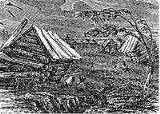
series beginning with an initial pair of very large earthquakes on December 16, 1811. These earthquakes remain the most powerful earthquakes ever to hit the eastern United States in recorded history. These events, as well as the seismic zone of their occurrence, were named for the Mississippi River
Mississippi River
The Mississippi River is the largest river system in North America. Flowing entirely in the United States, this river rises in western Minnesota and meanders slowly southwards for to the Mississippi River Delta at the Gulf of Mexico. With its many tributaries, the Mississippi's watershed drains...
town of New Madrid
New Madrid, Missouri
New Madrid is a city in New Madrid County, Missouri, 42 miles south by west of Cairo, Illinois, on the Mississippi River. New Madrid was founded in 1788 by American frontiersmen. In 1900, 1,489 people lived in New Madrid, Missouri; in 1910, the population was 1,882. The population was 3,334 at...
, then part of the Louisiana Territory
Louisiana Territory
The Territory of Louisiana or Louisiana Territory was an organized incorporated territory of the United States that existed from July 4, 1805 until June 4, 1812, when it was renamed to Missouri Territory...
, now within Missouri
Missouri
Missouri is a US state located in the Midwestern United States, bordered by Iowa, Illinois, Kentucky, Tennessee, Arkansas, Oklahoma, Kansas and Nebraska. With a 2010 population of 5,988,927, Missouri is the 18th most populous state in the nation and the fifth most populous in the Midwest. It...
.
There are estimates that the earthquakes were felt strongly over roughly 130000 square kilometres (50,193.3 sq mi), and moderately across nearly 3 million square kilometers (1 million square miles).
Unanswered Questions