

Yarralumla, Australian Capital Territory
Encyclopedia
Yarralumla is a large inner south suburb
of Canberra
, the capital city of Australia. Located approximately 3.5 kilometres (2.2 mi) south-west of the city, Yarralumla extends along the south-west bank of Lake Burley Griffin
. (The lake was created after the Second World War through the blocking, with a dam, of the Molonglo River
.)
Europeans first settled the area in 1828, and it was named Yarralumla in 1834 from the indigenous Ngunnawal people
's term for the area. (It is also spelt "Yarrowlumla" on some 19th century maps and other documents.)
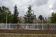
Frederick Campbell, grandson of Robert Campbell who built nearby "Duntroon
", completed the construction of a large, gabled, brick house on his property in 1891 that now serves as the site of Government House
, the official residence of the Governor-General of Australia
. Campbell's house replaced an elegant, Georgian-style homestead, the main portions of which were erected from local stone in the 1830s.
Among the old Yarralumla homestead's most notable occupants were Sir Terence Aubrey Murray, who owned Yarralumla sheep station from 1837 to 1859, Augustus Onslow Manby Gibbes, who owned the property from 1859 to 1881, and Augustus' father Colonel John George Nathaniel Gibbes (1787-1873). (Augustus "Gussie" Gibbes was Murray's brother-in-law; he also advanced money to Frederick Campbell to assist with the construction, in 1890-1891, of Campbell's grand new family house at Yarralumla.)
The modern suburb of Yarralumla was officially gazette
d by the government in 1928 and today is home to approximately 3000 people and many diplomatic mission
s. In recent years, it has become one of Canberra's most desirable and expensive residential suburbs because of its wide leafy streets, attractive lakeside setting and central location.
. It is bordered by Lake Burley Griffin to the north, Commonwealth Avenue
and Capital Hill
to the east, Adelaide Avenue and the Cotter Road to the south, and Scrivener Dam
, Lady Denman Drive and part of the Molonglo River
to the west.
Although Yarralumla is one of the largest suburbs in Canberra by area, its population remains quite small because more than half of its area consists of open space or non-residential development. Also, a relatively high proportion of houses are occupied by diplomatic missions: the people living in them are not counted in the Australian Census of Population and Housing. Yarralumla's open areas, Weston and Stirling Parks, the Royal Canberra Golf Club
, the grounds of Government House and its proximity to the city and Lake Burley Griffin, are the principal reasons for its growing popularity with house-seekers.
The embassy area of Yarralumla is located towards the eastern end of the suburb next to Stirling Park. It is the hilliest area of Yarralumla and was one of the most recent parts to be developed; Parliament House
and the Parliamentary Triangle
are located nearby.
The streets in Yarralumla are named after Australian governors
and botanists. Most of the older streets in the suburb are laid out on an approximately rectangular grid
with some curved sections, while the more hilly eastern end of the suburb, including the embassy district, is set out with contour-guided roads. Major roads in Yarralumla include Banks Street, Novar Street and Hopetoun Circuit in a north-south direction and Schlich Street, Loftus Street and Weston Street running east-west. Being a dormitory
suburb, there are no major through roads. Access to the rest of the city can be made from Adelaide Avenue, Commonwealth Avenue
, Lady Denman Drive and Cotter Road, all of which run along the borders of the suburb. From these roads, entry to the suburb can be gained by turning into roads such as Coronation Drive, Hopetoun Circuit and Novar Street.
Yarralumla is located on the Yarralumla Formation which is a mudstone
/siltstone
formation that was formed around 425 million years ago during the Silurian Period. The formation extends from Red Hill
and Woden
in the South to Lake Burley Griffin in to the north, passing under the suburb of Yarralumla. The formation is evidence of the last major marine sedimentary period when eastern Australia was still covered by shallow seas. It shows fossil evidence of trilobite
s, coral
and primitive crinoid
s. The Yarralumla brickworks quarry and the Deakin
anticline are places where the formation is exposed and easily studied.
 The area now called Yarralumla is part of two original land grant
s, which were granted to free settlers for the establishment of farms. In 1828 Henry Donnison, a Sydney merchant who had arrived with his wife and family on the brig Ellen on 29–30 July 1828, was granted an allotment on the western side of Stirling Ridge. A second grant was made to William Klensendorlffe (a German who had served in the British Navy and arrived free in the Colony in 1818), who had bought the land from John Stephen, on 7 March 1839. Donnison's land was officially named Yarralumla in a survey of the area conducted in 1834. Yarralumla was a name for the area used by the local Ngunnawal people
, apparently meaning "echo". The area nearby to the west of what is now the suburb was the Yarrolumla parish.
The prominent New South Wales parliamentarian, Sir Terence Aubrey Murray (1810–1873) purchased Yarralumla in 1837. He lived there with his wife Mary Murray (née Gibbes, 1817–1858), the second daughter of the Collector of Customs for NSW, Colonel John George Nathaniel Gibbes (1787-1873), MLC. In 1859, Murray sold Yarralumla to his brother-in-law, Augustus Onslow Manby Gibbes (1828–1897). Later that same year, Augustus' parents came to live with him at Yarralumla homestead.
Augustus Gibbes improved the estate and acquired additional land by purchase and lease. However, In 1881, he sold Yarralumla for 40,000 pounds to Frederick Campbell, a descendant of Robert Campbell, in order to travel overseas. Frederick Campbell erected a new, three-storey, brick house on the site of the former Yarralumla homestead at the beginning of the 1890s. Campbell's house would later form the basis of what is now the Governor-General of Australia's official Canberra residence, known colloquially as "Yarralumla" or "Government House". Campbell also built a large wooden woolshed nearby in 1904. It remains standing to this day.
In 1908, the Limestone Plains area, including Yarralumla, was selected as the site for the capital city of the newly established Commonwealth of Australia. Soon afterwards in 1913, the Commonwealth Government
purchased the property. Tenant farmers were allowed to stay on the land on annual leases, some remaining until 1963 when the Molonglo River was dammed to form Lake Burley Griffin.
were established in 1913 to supply building material. The bricks were used for many of Canberra's buildings, including the provisional Parliament House
. In 1917, Walter Burley Griffin named the area surrounding the brickworks "Westridge".
A narrow gauge goods railway was constructed for the transportation of bricks to some of the major building sites in central Canberra. This linked the brickworks to places such as Parliament House, and the Kingston
Power House.
 Construction on the Commonwealth nursery and Westbourne Woods
arboretum
was started in 1914, and a temporary camp was built near the brickworks to accommodate the workers. Thomas Charles Weston was Officer-in-Charge (Afforestation Branch) in the years 1913 to 1926, and later became Director of City Planting and the Superintendent of Parks and Gardens. Weston was responsible for testing and selecting plant species at the arboretum for their suitability to Canberra's environment; from 1913 through to 1924 Weston oversaw the propagation of more than two million trees which were then planted in the Canberra area. Most of the original Westbourne Woods arboretum is now leased to the Royal Canberra Golf Club
, with the remainder forming part of Weston Park
. The Yarralumla nursery is still active, albeit on a smaller scale and functioning as a retail nursery selling both wholesale and direct to the public.
In 1922, a workers' tent camp was erected in the area on the eastern side of Stirling Ridge to house the men working on the main intercepting sewer. The following year saw the start of the construction of 62 small, four-room, unlined timber cottages, to be used as housing for the married tradesmen involved in the construction of the provisional Parliament House. Other camps were established at the eastern end of Stirling Park on the hills opposite modern Lotus Bay. The first of these was contractor John Howie's settlement (1922–30), consisting of 25 timber cottages for his married men and timber barracks (Hostel Camp) for his single men. Two other single men's tent camps were established nearby–Old Tradesmen's Camp (1923–27) and No 1 Labourers Camp (1924–27). The men from Howie's worked on the Hotel Canberra
and the others on the construction of the provisional Parliament House and nearby administrative buildings.
The Stirling Park camps were known as "Westlake" to their new inhabitants, and previously "Gura Bung Dhaura" (stony ground) to the local Aboriginal
people. In 1925, the population of this temporary suburb was 700. This represented roughly one-fifth of the total population of the Federal Capital Territory at the time; in the region, only Molonglo Settlement had a larger population, at 750. The site was chosen so that it was near to Parliament House but hidden from direct line of sight from anywhere "important". The small cottages at Westlake were removed starting in the mid-1950s, with the last one removed in 1965. Many of the Westlake workers' cottages were moved to Queanbeyan and are still used as housing today. The Stirling Park near the embassy area of Yarralumla now covers the historic Westlake settlement area. Some evidence of these former dwellings still remains today, and signage has been erected to commemorate these pioneering people of early Canberra.
The Commonwealth Forestry School was established in Westridge near the brickworks and Westbourne Woods in 1926. It opened with its first intake of students in the following year. Today the heritage-listed Forestry School and the associated principal's residence Westridge House are located on Banks Street, Yarralumla. CSIRO
Forestry and Forestry Products subsumed the school in 1975. Westridge House, an impressive Tudor-style
structure, recently underwent a A$
500,000 refurbishment and is presently in use as a residence for the chief officer of the CSIRO.
The forestry students were housed in small timber cubicles in the vicinity of modern Solander Crescent. Three nearby houses were shells of buildings and used by the students for a mess, recreation and ablution purposes. The first mess caterer was Mrs Dora Riddle (née Horan).
By 1928, there were over 130 people on the electoral roll for Westridge. The majority of the population consisted of men working at the brickworks and nursery. Westridge was officially gazetted as a Canberra suburb in 1928. Its residential area was situated adjacent to the proposed site for Lake Burley Griffin, close to Westbourne Woods and the 53-hectare
(131 acre
) grounds of the Governor-General's official establishment.
 Westridge was officially renamed Yarralumla in the 1950s. In 1963, Lake Burley Griffin was filled and Yarralumla was expanded to include Westlake, which had up until then been officially part of Acton
.
After World War II
, the suburb began to expand rapidly with the construction of many private homes. Yarralumla's image as a "lower-class" suburb would persist into the 1960s and 1970s. This general perception began to alter once Lake Burley Griffin had been created and its surrounds landscaped into parklands; the area soon gained a reputation for its attractive lakeside location. During the 1980s, house prices began to rise coincident with a rejuvenation of the suburb. Large numbers of the original government-built monocrete
, brick and weatherboard houses have now been demolished and replaced by larger dwellings of a variety of more modern styles and materials. The suburb is generally regarded as one of the more desirable in Canberra.
Yarralumla is a comparatively wealthy suburb with the median weekly income of $969; this compares to a Canberra-wide figure of $723 and an Australia-wide figure of $466. In line with the Canberra average, the public service or defence force employed around 23% of the workforce. This compares to 2.0% for Australia as a whole. The higher incomes are derived on the suburb's white-collar base; 63.3% of Yarralumla's workforce is employed as professionals or in managerial posts, compared to 33% nationally. In contrast, only 4.8% were engaged in blue-collar occupations, compared with 17.1% for the nation as a whole. The proportion of the population working as tradesmen and technicians is almost three times lower than average across Australia.
The median monthly housing loan repayments in Yarralumla were $2164, compared to the Canberra-wide figure of $1500 and a federal average of $1300. At $288, the weekly rent is more than 50% higher than the national average. In 2008 Yarralumla's median house price was $1m versus $452,500 for the whole of the ACT. The rate of home ownership in the suburb is 41.6% much higher than the national average of 32.6%. Almost one third of the households rent, and about a tenth do so from public housing authorities. Accommodation is mostly separate houses (72.5%), although the number of residences in the suburb has been increasing through conversion of blocks to dual occupancy and other medium-density-type developments. Despite this, only 5.0% live in an apartment or unit, little more than one third of the national average.
The population of Yarralumla is predominantly Australian-born, with some 69.7% of its residents being born in Australia. The second most prevalent birthplace is England at 6.4%, followed by New Zealand and India with 2.0 and 1.4% respectively. The suburb is more oriented towards the Anglo-Celtic majority than the rest of Australia; English is spoken at home by 83.7% of the population, compared to the national average of 78.5%. Every other language is spoken by less than 1% of the population. German, Italian, Hindi, Greek and Spanish are all spoken by at least 0.5% of the population. The most popular religious affiliations in descending order are no religion, Roman Catholic, Anglican
, Uniting
and Presbyterian
. The proportion of the population professing to having no religion was 26.2%, higher than the national average of 18.7%.
, bakery
, dry-cleaners, video store/post office, chemist
, gift shop and newsagent as well as several restaurants and speciality shops. The shopping area has undergone redevelopment in recent years, including the addition of a two-storey office development facing the shopping centre.
Yarralumla's first school, the Catholic St Peter Chanel's Primary School, opened in 1956; it later closed in the 1990s. Yarralumla Primary School
, a public school, opened a year after St Peter Chanel's in 1957. Half of the original primary school is now used as a behavioural centre catering to problem students. There are two preschools
in Yarralumla: Hill Corner Preschool, which is now the St Nicholas Greek-Australian Preschool; and the Montessori preschool
, which is located in the former St Peter Chanel's Primary school buildings. There is also a newly-opened day care facility called Little Lodge on Macgillivray St.
Weston Park
is situated on a peninsula near the western end of Lake Burley Griffin. The park includes swimming areas, children's play equipment and wading pools, and a miniature railway, and is a popular barbecue
spot on weekends. Weston Park forms part of a string of parks that line the southern shore of Lake Burley Griffin; other parks include Yarralumla Bay, Lennox Gardens (incorporating a Japanese garden named Canberra Nara Park) and Stirling Park.
Like most of Canberra, Yarralumla's only scheduled public transport is provided by ACTION
buses. On weekdays, route 2 provides a service from Yarralumla to Woden
and City Interchanges along Novar Street, Schlich Street and Hopetoun Circuit. Route 2 operates every 30 minutes until 6pm and hourly from 6pm to 11pm. On weekends and public holidays, route 932 provides an hourly service along the same streets as route 2.
Yarralumla is located within the federal electorate
of Canberra
. Gai Brodtmann
currently (2010) represents the electorate of Canberra in the House of Representatives
. Historically both federal electorates in the ACT are safe Labor
seats. Polling place statistics are shown to the right for the Yarralumla polling place in the 2004 federal and ACT elections.
In the ACT Legislative Assembly
, Yarralumla is part of the electorate of Molonglo, which elects seven members on the basis of proportional representation. The 2004 ACT election saw a swing of 7.3% towards the Labor Party and 4.1% away from the Liberal Party
.
The Yarralumla Residents Association (YRA) is a registered organisation formed to represent the views of Yarralumla residents and business. The group stands against government plans for "urban consolidation", supporting open space and the conservation of low-density housing. The organisation has been very vocal in opposing government plans for further development of Yarralumla and is also vocal about any plans for the Yarralumla Brickworks site.
's residence Government House
, which shares the name Yarralumla, is located at the western end of the suburb in 53 hectares (131 acres) of parkland. It sits alongside Lake Burley Griffin, next to the Royal Canberra Golf Club
and Scrivener Dam. The house was built in 1891 as the headquarters for the Yarralumla property. Also located alongside Scrivener Dam is the National Zoo & Aquarium
. The nearby Yarralumla Woolshed is available for event hire, often playing host to parties and bush dances. The land surrounding the woolshed has been developed as an equestrian
park, including areas for showjumping, eventing
and endurance riding
.
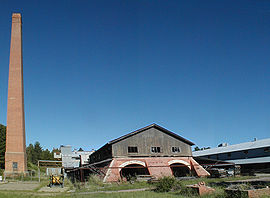
The Yarralumla brickworks are notable as the first industrial manufacturing facility in the ACT. The brickworks were closed temporarily several times due to the Great Depression
and both World Wars
. They closed permanently in 1976 after plans for major modernisation upgrades were not proceeded with. Presently the site is closed to the public and is in a state of disrepair. The unfenced parkland around the brickworks is a popular recreation area for Yarralumla residents. Future plans for the site have not yet been decided.
 The eastern end of Yarralumla is home to many of the diplomatic mission
s in Canberra, many of which are built in a traditional style reflecting that of their respective home countries. Examples of regionally styled chanceries include the embassies of Saudi Arabia
and Thailand
, and the High Commissions
of India and Papua New Guinea
. The United States embassy
was the first embassy built in Canberra, with the foundation stone laid on the Fourth of July
, 1942. The embassy is an impressive compound of buildings built in a Georgian
style, inspired by several buildings designed by Christopher Wren
for Virginia
at the beginning of the 18th century. Canberra tourist drive six takes tourists on a car-based tour past many of Canberra's embassies including those located in Yarralumla. It zig-zags through the eastern side of Yarralumla past many of the missions.
Also located in the eastern end of the suburb are Lennox Gardens, the Yarralumla Yacht Club, the Albert Hall
and the Hotel Canberra
. The Hotel Canberra opened in 1924 to accommodate politicians when Parliament was in session. The hotel was closed in 1974 and the buildings served as an annexe for Parliament House between 1976 and 1984. The Hyatt Hotel Group
re-opened the hotel in 1987.
Suburb
The word suburb mostly refers to a residential area, either existing as part of a city or as a separate residential community within commuting distance of a city . Some suburbs have a degree of administrative autonomy, and most have lower population density than inner city neighborhoods...
of Canberra
Canberra
Canberra is the capital city of Australia. With a population of over 345,000, it is Australia's largest inland city and the eighth-largest city overall. The city is located at the northern end of the Australian Capital Territory , south-west of Sydney, and north-east of Melbourne...
, the capital city of Australia. Located approximately 3.5 kilometres (2.2 mi) south-west of the city, Yarralumla extends along the south-west bank of Lake Burley Griffin
Lake Burley Griffin
Lake Burley Griffin is an artificial lake in the centre of Canberra, the capital of Australia. It was completed in 1963 after the Molonglo River—which ran between the city centre and Parliamentary Triangle—was dammed...
. (The lake was created after the Second World War through the blocking, with a dam, of the Molonglo River
Molonglo River
The Molonglo River rises on the western side of the Great Dividing Range of eastern Australia in the state of New South Wales. Its source is on the other side of the mountain range from where the Shoalhaven River rises, in Tallaganda state forest at ~1200 metres altitude...
.)
Europeans first settled the area in 1828, and it was named Yarralumla in 1834 from the indigenous Ngunnawal people
Ngunnawal people
The Ngunnawal people are the Indigenous Australian inhabitants whose traditional lands encompass much of the area now occupied by the city of Canberra, Australia and the surrounding Australian Capital Territory...
's term for the area. (It is also spelt "Yarrowlumla" on some 19th century maps and other documents.)
Frederick Campbell, grandson of Robert Campbell who built nearby "Duntroon
Duntroon, Australian Capital Territory
Duntroon is a suburb of the city of Canberra in the Australian Capital Territory.-History:Robert Campbell's property Duntroon was situated on the limestone plains of New South Wales in the area that is now covered by the ACT....
", completed the construction of a large, gabled, brick house on his property in 1891 that now serves as the site of Government House
Government House, Canberra
Government House, Canberra, commonly known as Yarralumla, is the official residence of the Governor-General of Australia. It is located in the suburb of Yarralumla, in the City of Canberra, in the Australian Capital Territory....
, the official residence of the Governor-General of Australia
Governor-General of Australia
The Governor-General of the Commonwealth of Australia is the representative in Australia at federal/national level of the Australian monarch . He or she exercises the supreme executive power of the Commonwealth...
. Campbell's house replaced an elegant, Georgian-style homestead, the main portions of which were erected from local stone in the 1830s.
Among the old Yarralumla homestead's most notable occupants were Sir Terence Aubrey Murray, who owned Yarralumla sheep station from 1837 to 1859, Augustus Onslow Manby Gibbes, who owned the property from 1859 to 1881, and Augustus' father Colonel John George Nathaniel Gibbes (1787-1873). (Augustus "Gussie" Gibbes was Murray's brother-in-law; he also advanced money to Frederick Campbell to assist with the construction, in 1890-1891, of Campbell's grand new family house at Yarralumla.)
The modern suburb of Yarralumla was officially gazette
Gazette
A gazette is a public journal, a newspaper of record, or simply a newspaper.In English- and French-speaking countries, newspaper publishers have applied the name Gazette since the 17th century; today, numerous weekly and daily newspapers bear the name The Gazette.Gazette is a loanword from the...
d by the government in 1928 and today is home to approximately 3000 people and many diplomatic mission
Diplomatic mission
A diplomatic mission is a group of people from one state or an international inter-governmental organisation present in another state to represent the sending state/organisation in the receiving state...
s. In recent years, it has become one of Canberra's most desirable and expensive residential suburbs because of its wide leafy streets, attractive lakeside setting and central location.
Geography
Yarralumla is located in the central Canberra district of South CanberraSouth Canberra
South Canberra or the Inner South is a central district of Canberra, the capital city of Australia.South Canberra is located to the south of Canberra's city centre, on the south bank of Lake Burley Griffin....
. It is bordered by Lake Burley Griffin to the north, Commonwealth Avenue
Commonwealth Avenue, Canberra
Commonwealth Avenue is a major road in Canberra, Australian Capital Territory, Australia. It connects Civic with South Canberra. Specifically, it runs between City Hill and Capital Hill....
and Capital Hill
Capital Hill, Australian Capital Territory
Capital Hill , is the location of Parliament House, Canberra, at the south apex of the land axis of the Parliamentary Triangle....
to the east, Adelaide Avenue and the Cotter Road to the south, and Scrivener Dam
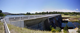
Scrivener Dam
Scrivener Dam is a concrete gravity dam in Canberra, Australia. It was completed in 1963 across the Molonglo River to create Lake Burley Griffin in the middle of Canberra. It was named in honour of the surveyor Charles Scrivener. The dam is located at . It was engineered to withstand a...
, Lady Denman Drive and part of the Molonglo River
Molonglo River
The Molonglo River rises on the western side of the Great Dividing Range of eastern Australia in the state of New South Wales. Its source is on the other side of the mountain range from where the Shoalhaven River rises, in Tallaganda state forest at ~1200 metres altitude...
to the west.
Although Yarralumla is one of the largest suburbs in Canberra by area, its population remains quite small because more than half of its area consists of open space or non-residential development. Also, a relatively high proportion of houses are occupied by diplomatic missions: the people living in them are not counted in the Australian Census of Population and Housing. Yarralumla's open areas, Weston and Stirling Parks, the Royal Canberra Golf Club
Royal Canberra Golf Club
The Canberra Golf Club, later known as the Royal Canberra Golf Club, was formed in 1926. Its original grounds were behind the Hotel Canberra on the river flats on both sides of the Molonglo River....
, the grounds of Government House and its proximity to the city and Lake Burley Griffin, are the principal reasons for its growing popularity with house-seekers.
The embassy area of Yarralumla is located towards the eastern end of the suburb next to Stirling Park. It is the hilliest area of Yarralumla and was one of the most recent parts to be developed; Parliament House
Parliament House, Canberra
Parliament House is the meeting facility of the Parliament of Australia located in Canberra, the capital of Australia. The building was designed by Mitchell/Giurgola Architects and opened on 1988 by Elizabeth II, Queen of Australia...
and the Parliamentary Triangle
Parliamentary Triangle, Canberra
The Parliamentary Triangle is the ceremonial precinct of Canberra, containing some of Australia's most significant buildings. The triangle is formed by Commonwealth, Kings and Constitution avenues...
are located nearby.
The streets in Yarralumla are named after Australian governors
Governors of the Australian states
The Governors of the Australian states are the representatives of the Queen of Australia in each of that country's six states. The Governors perform the same constitutional and ceremonial functions at the state level as does the Governor-General of Australia at the national level...
and botanists. Most of the older streets in the suburb are laid out on an approximately rectangular grid
Grid plan
The grid plan, grid street plan or gridiron plan is a type of city plan in which streets run at right angles to each other, forming a grid...
with some curved sections, while the more hilly eastern end of the suburb, including the embassy district, is set out with contour-guided roads. Major roads in Yarralumla include Banks Street, Novar Street and Hopetoun Circuit in a north-south direction and Schlich Street, Loftus Street and Weston Street running east-west. Being a dormitory
Dormitory
A dormitory, often shortened to dorm, in the United States is a residence hall consisting of sleeping quarters or entire buildings primarily providing sleeping and residential quarters for large numbers of people, often boarding school, college or university students...
suburb, there are no major through roads. Access to the rest of the city can be made from Adelaide Avenue, Commonwealth Avenue
Commonwealth Avenue, Canberra
Commonwealth Avenue is a major road in Canberra, Australian Capital Territory, Australia. It connects Civic with South Canberra. Specifically, it runs between City Hill and Capital Hill....
, Lady Denman Drive and Cotter Road, all of which run along the borders of the suburb. From these roads, entry to the suburb can be gained by turning into roads such as Coronation Drive, Hopetoun Circuit and Novar Street.
Yarralumla is located on the Yarralumla Formation which is a mudstone
Mudstone
Mudstone is a fine grained sedimentary rock whose original constituents were clays or muds. Grain size is up to 0.0625 mm with individual grains too small to be distinguished without a microscope. With increased pressure over time the platey clay minerals may become aligned, with the...
/siltstone
Siltstone
Siltstone is a sedimentary rock which has a grain size in the silt range, finer than sandstone and coarser than claystones.- Description :As its name implies, it is primarily composed of silt sized particles, defined as grains 1/16 - 1/256 mm or 4 to 8 on the Krumbein phi scale...
formation that was formed around 425 million years ago during the Silurian Period. The formation extends from Red Hill
Red Hill, Australian Capital Territory
Red Hill is a suburb of Canberra, Australian Capital Territory, Australia. The suburb is named after the northernmost hill of the ridge to the west of the suburb. The ridge is a reserve and managed as part of the Canberra Nature Park. The hill is an element of the central Canberra design...
and Woden
Woden Town Centre
Woden Town Centre is the main commercial centre of the district of Woden Valley in Canberra, Australia. It is located in the Canberra suburb of Phillip....
in the South to Lake Burley Griffin in to the north, passing under the suburb of Yarralumla. The formation is evidence of the last major marine sedimentary period when eastern Australia was still covered by shallow seas. It shows fossil evidence of trilobite
Trilobite
Trilobites are a well-known fossil group of extinct marine arthropods that form the class Trilobita. The first appearance of trilobites in the fossil record defines the base of the Atdabanian stage of the Early Cambrian period , and they flourished throughout the lower Paleozoic era before...
s, coral
Coral
Corals are marine animals in class Anthozoa of phylum Cnidaria typically living in compact colonies of many identical individual "polyps". The group includes the important reef builders that inhabit tropical oceans and secrete calcium carbonate to form a hard skeleton.A coral "head" is a colony of...
and primitive crinoid
Crinoid
Crinoids are marine animals that make up the class Crinoidea of the echinoderms . Crinoidea comes from the Greek word krinon, "a lily", and eidos, "form". They live both in shallow water and in depths as great as 6,000 meters. Sea lilies refer to the crinoids which, in their adult form, are...
s. The Yarralumla brickworks quarry and the Deakin
Deakin, Australian Capital Territory
Deakin is a suburb of Canberra, Australian Capital Territory, Australia. Deakin is named after Alfred Deakin, second prime minister of Australia...
anticline are places where the formation is exposed and easily studied.
Settlement
Land grant
A land grant is a gift of real estate – land or its privileges – made by a government or other authority as a reward for services to an individual, especially in return for military service...
s, which were granted to free settlers for the establishment of farms. In 1828 Henry Donnison, a Sydney merchant who had arrived with his wife and family on the brig Ellen on 29–30 July 1828, was granted an allotment on the western side of Stirling Ridge. A second grant was made to William Klensendorlffe (a German who had served in the British Navy and arrived free in the Colony in 1818), who had bought the land from John Stephen, on 7 March 1839. Donnison's land was officially named Yarralumla in a survey of the area conducted in 1834. Yarralumla was a name for the area used by the local Ngunnawal people
Ngunnawal people
The Ngunnawal people are the Indigenous Australian inhabitants whose traditional lands encompass much of the area now occupied by the city of Canberra, Australia and the surrounding Australian Capital Territory...
, apparently meaning "echo". The area nearby to the west of what is now the suburb was the Yarrolumla parish.
The prominent New South Wales parliamentarian, Sir Terence Aubrey Murray (1810–1873) purchased Yarralumla in 1837. He lived there with his wife Mary Murray (née Gibbes, 1817–1858), the second daughter of the Collector of Customs for NSW, Colonel John George Nathaniel Gibbes (1787-1873), MLC. In 1859, Murray sold Yarralumla to his brother-in-law, Augustus Onslow Manby Gibbes (1828–1897). Later that same year, Augustus' parents came to live with him at Yarralumla homestead.
Augustus Gibbes improved the estate and acquired additional land by purchase and lease. However, In 1881, he sold Yarralumla for 40,000 pounds to Frederick Campbell, a descendant of Robert Campbell, in order to travel overseas. Frederick Campbell erected a new, three-storey, brick house on the site of the former Yarralumla homestead at the beginning of the 1890s. Campbell's house would later form the basis of what is now the Governor-General of Australia's official Canberra residence, known colloquially as "Yarralumla" or "Government House". Campbell also built a large wooden woolshed nearby in 1904. It remains standing to this day.
In 1908, the Limestone Plains area, including Yarralumla, was selected as the site for the capital city of the newly established Commonwealth of Australia. Soon afterwards in 1913, the Commonwealth Government
Government of Australia
The Commonwealth of Australia is a federal constitutional monarchy under a parliamentary democracy. The Commonwealth of Australia was formed in 1901 as a result of an agreement among six self-governing British colonies, which became the six states...
purchased the property. Tenant farmers were allowed to stay on the land on annual leases, some remaining until 1963 when the Molonglo River was dammed to form Lake Burley Griffin.
Development
With the construction of Australia's capital city underway, the Yarralumla brickworksYarralumla brickworks
The Yarralumla brickworks, also known as the Commonwealth Brickworks, was one of the earliest construction projects in Canberra, Australia. It was built in the suburb of Yarralumla to produce the bricks used to build many of Canberra's early buildings. It opened in around 1913 and operated until...
were established in 1913 to supply building material. The bricks were used for many of Canberra's buildings, including the provisional Parliament House
Old Parliament House, Canberra
Old Parliament House, known formerly as the Provisional Parliament House, was the house of the Parliament of Australia from 1927 to 1988. The building began operation on 9 May 1927 as a temporary base for the Commonwealth Parliament after its relocation from Melbourne to the new capital, Canberra,...
. In 1917, Walter Burley Griffin named the area surrounding the brickworks "Westridge".
A narrow gauge goods railway was constructed for the transportation of bricks to some of the major building sites in central Canberra. This linked the brickworks to places such as Parliament House, and the Kingston
Kingston, Australian Capital Territory
Kingston is the oldest and most densely populated suburb of Canberra, Australian Capital Territory, Australia. The suburb is named after Charles Cameron Kingston, the former Premier of South Australia and minister in the first Australian Commonwealth Government. It is adjacent to the suburbs of...
Power House.
Westbourne Woods
Westbourne Woods is an area of exotic tree plantings in the Canberra suburb of Yarralumla in the Australian Capital Territory.The woods were established by Thomas Weston as an experimental planting area in 1913 and cover 120 hectares. The names of the woods comes from Walter Burley Griffin's...
arboretum
Arboretum
An arboretum in a narrow sense is a collection of trees only. Related collections include a fruticetum , and a viticetum, a collection of vines. More commonly, today, an arboretum is a botanical garden containing living collections of woody plants intended at least partly for scientific study...
was started in 1914, and a temporary camp was built near the brickworks to accommodate the workers. Thomas Charles Weston was Officer-in-Charge (Afforestation Branch) in the years 1913 to 1926, and later became Director of City Planting and the Superintendent of Parks and Gardens. Weston was responsible for testing and selecting plant species at the arboretum for their suitability to Canberra's environment; from 1913 through to 1924 Weston oversaw the propagation of more than two million trees which were then planted in the Canberra area. Most of the original Westbourne Woods arboretum is now leased to the Royal Canberra Golf Club
Royal Canberra Golf Club
The Canberra Golf Club, later known as the Royal Canberra Golf Club, was formed in 1926. Its original grounds were behind the Hotel Canberra on the river flats on both sides of the Molonglo River....
, with the remainder forming part of Weston Park
Weston Park, Canberra
Weston Park is a park located on a peninsula on the western side of Lake Burley Griffin in Canberra, Australia. In 1963 the park was named after Charles Weston, who had founded the nearby Yarralumla Nursery in 1914. On the western side of the peninsula is Yarramundi Reach and on the eastern side is...
. The Yarralumla nursery is still active, albeit on a smaller scale and functioning as a retail nursery selling both wholesale and direct to the public.
In 1922, a workers' tent camp was erected in the area on the eastern side of Stirling Ridge to house the men working on the main intercepting sewer. The following year saw the start of the construction of 62 small, four-room, unlined timber cottages, to be used as housing for the married tradesmen involved in the construction of the provisional Parliament House. Other camps were established at the eastern end of Stirling Park on the hills opposite modern Lotus Bay. The first of these was contractor John Howie's settlement (1922–30), consisting of 25 timber cottages for his married men and timber barracks (Hostel Camp) for his single men. Two other single men's tent camps were established nearby–Old Tradesmen's Camp (1923–27) and No 1 Labourers Camp (1924–27). The men from Howie's worked on the Hotel Canberra
Hotel Canberra
The Hotel Canberra, also known as Hyatt Hotel Canberra is in Yarralumla, near Lake Burley Griffin and Parliament House, in Canberra. It was built to house politicians when the Federal Parliament moved to Canberra. It was constructed by the contractor John Howie between 1922-1925. Originally...
and the others on the construction of the provisional Parliament House and nearby administrative buildings.
The Stirling Park camps were known as "Westlake" to their new inhabitants, and previously "Gura Bung Dhaura" (stony ground) to the local Aboriginal
Indigenous Australians
Indigenous Australians are the original inhabitants of the Australian continent and nearby islands. The Aboriginal Indigenous Australians migrated from the Indian continent around 75,000 to 100,000 years ago....
people. In 1925, the population of this temporary suburb was 700. This represented roughly one-fifth of the total population of the Federal Capital Territory at the time; in the region, only Molonglo Settlement had a larger population, at 750. The site was chosen so that it was near to Parliament House but hidden from direct line of sight from anywhere "important". The small cottages at Westlake were removed starting in the mid-1950s, with the last one removed in 1965. Many of the Westlake workers' cottages were moved to Queanbeyan and are still used as housing today. The Stirling Park near the embassy area of Yarralumla now covers the historic Westlake settlement area. Some evidence of these former dwellings still remains today, and signage has been erected to commemorate these pioneering people of early Canberra.
The Commonwealth Forestry School was established in Westridge near the brickworks and Westbourne Woods in 1926. It opened with its first intake of students in the following year. Today the heritage-listed Forestry School and the associated principal's residence Westridge House are located on Banks Street, Yarralumla. CSIRO
Commonwealth Scientific and Industrial Research Organisation
The Commonwealth Scientific and Industrial Research Organisation is the national government body for scientific research in Australia...
Forestry and Forestry Products subsumed the school in 1975. Westridge House, an impressive Tudor-style
Tudor architecture
The Tudor architectural style is the final development of medieval architecture during the Tudor period and even beyond, for conservative college patrons...
structure, recently underwent a A$
Australian dollar
The Australian dollar is the currency of the Commonwealth of Australia, including Christmas Island, Cocos Islands, and Norfolk Island, as well as the independent Pacific Island states of Kiribati, Nauru and Tuvalu...
500,000 refurbishment and is presently in use as a residence for the chief officer of the CSIRO.
The forestry students were housed in small timber cubicles in the vicinity of modern Solander Crescent. Three nearby houses were shells of buildings and used by the students for a mess, recreation and ablution purposes. The first mess caterer was Mrs Dora Riddle (née Horan).
By 1928, there were over 130 people on the electoral roll for Westridge. The majority of the population consisted of men working at the brickworks and nursery. Westridge was officially gazetted as a Canberra suburb in 1928. Its residential area was situated adjacent to the proposed site for Lake Burley Griffin, close to Westbourne Woods and the 53-hectare
Hectare
The hectare is a metric unit of area defined as 10,000 square metres , and primarily used in the measurement of land. In 1795, when the metric system was introduced, the are was defined as being 100 square metres and the hectare was thus 100 ares or 1/100 km2...
(131 acre
Acre
The acre is a unit of area in a number of different systems, including the imperial and U.S. customary systems. The most commonly used acres today are the international acre and, in the United States, the survey acre. The most common use of the acre is to measure tracts of land.The acre is related...
) grounds of the Governor-General's official establishment.
Post WWII
Acton, Australian Capital Territory
Acton is a suburb of Canberra, Australia. Acton covers an area west of the CBD, bordered by Black Mountain to the west and Lake Burley Griffin in the south...
.
After World War II
World War II
World War II, or the Second World War , was a global conflict lasting from 1939 to 1945, involving most of the world's nations—including all of the great powers—eventually forming two opposing military alliances: the Allies and the Axis...
, the suburb began to expand rapidly with the construction of many private homes. Yarralumla's image as a "lower-class" suburb would persist into the 1960s and 1970s. This general perception began to alter once Lake Burley Griffin had been created and its surrounds landscaped into parklands; the area soon gained a reputation for its attractive lakeside location. During the 1980s, house prices began to rise coincident with a rejuvenation of the suburb. Large numbers of the original government-built monocrete
Monocrete construction
Monocrete is a building construction method utilising modular bolt-together pre-cast concrete wall panels.Monocrete construction was widely used in the construction of government housing in the 1940s and 1950s in Canberra, Australia...
, brick and weatherboard houses have now been demolished and replaced by larger dwellings of a variety of more modern styles and materials. The suburb is generally regarded as one of the more desirable in Canberra.
Demographics
The population of the Westridge area on the 1928 electoral roll numbered over 130. On Census night 2006, Yarralumla had a population of 2907 people. Of these 49.1% were male. The suburb has only 0.7% indigenous Australians, substantially below the national average of 2.3%. The percentage of married people in the suburb is five points higher than the national average, and proportion of residents who have never married is lower by a corresponding amount. Despite the higher level of marriage, this does not translate into a higher level of children; 47.7% of families consist of a couple without children in the household, compared to the national average of 37.2%. The average household consists of 2.4 people, marginally less than the national average of 2.6. The 2006 Census shows that Yarralumla residents have a median age of 45, compared to a Canberra average of 34. The suburb has an older population for a city of young people; the median national age is 37 and 35.1% of Yarralumla residents are 55 or over, compared to the national figure of 24.3%.Yarralumla is a comparatively wealthy suburb with the median weekly income of $969; this compares to a Canberra-wide figure of $723 and an Australia-wide figure of $466. In line with the Canberra average, the public service or defence force employed around 23% of the workforce. This compares to 2.0% for Australia as a whole. The higher incomes are derived on the suburb's white-collar base; 63.3% of Yarralumla's workforce is employed as professionals or in managerial posts, compared to 33% nationally. In contrast, only 4.8% were engaged in blue-collar occupations, compared with 17.1% for the nation as a whole. The proportion of the population working as tradesmen and technicians is almost three times lower than average across Australia.
The median monthly housing loan repayments in Yarralumla were $2164, compared to the Canberra-wide figure of $1500 and a federal average of $1300. At $288, the weekly rent is more than 50% higher than the national average. In 2008 Yarralumla's median house price was $1m versus $452,500 for the whole of the ACT. The rate of home ownership in the suburb is 41.6% much higher than the national average of 32.6%. Almost one third of the households rent, and about a tenth do so from public housing authorities. Accommodation is mostly separate houses (72.5%), although the number of residences in the suburb has been increasing through conversion of blocks to dual occupancy and other medium-density-type developments. Despite this, only 5.0% live in an apartment or unit, little more than one third of the national average.
The population of Yarralumla is predominantly Australian-born, with some 69.7% of its residents being born in Australia. The second most prevalent birthplace is England at 6.4%, followed by New Zealand and India with 2.0 and 1.4% respectively. The suburb is more oriented towards the Anglo-Celtic majority than the rest of Australia; English is spoken at home by 83.7% of the population, compared to the national average of 78.5%. Every other language is spoken by less than 1% of the population. German, Italian, Hindi, Greek and Spanish are all spoken by at least 0.5% of the population. The most popular religious affiliations in descending order are no religion, Roman Catholic, Anglican
Anglican Church of Australia
The Anglican Church of Australia is a member church of the Anglican Communion. It was previously officially known as the Church of England in Australia and Tasmania...
, Uniting
Uniting Church in Australia
The Uniting Church in Australia was formed on 22 June 1977 when many congregations of the Methodist Church of Australasia, the Presbyterian Church of Australia and the Congregational Union of Australia came together under the Basis of Union....
and Presbyterian
Presbyterianism
Presbyterianism refers to a number of Christian churches adhering to the Calvinist theological tradition within Protestantism, which are organized according to a characteristic Presbyterian polity. Presbyterian theology typically emphasizes the sovereignty of God, the authority of the Scriptures,...
. The proportion of the population professing to having no religion was 26.2%, higher than the national average of 18.7%.
Suburb amenities
The Yarralumla local shopping centre is located on the corner of Bentham and Novar Streets. The centre contains a supermarketSupermarket
A supermarket, a form of grocery store, is a self-service store offering a wide variety of food and household merchandise, organized into departments...
, bakery
Bakery
A bakery is an establishment which produces and sells flour-based food baked in an oven such as bread, cakes, pastries and pies. Some retail bakeries are also cafés, serving coffee and tea to customers who wish to consume the baked goods on the premises.-See also:*Baker*Cake...
, dry-cleaners, video store/post office, chemist
Pharmacist
Pharmacists are allied health professionals who practice in pharmacy, the field of health sciences focusing on safe and effective medication use...
, gift shop and newsagent as well as several restaurants and speciality shops. The shopping area has undergone redevelopment in recent years, including the addition of a two-storey office development facing the shopping centre.
Yarralumla's first school, the Catholic St Peter Chanel's Primary School, opened in 1956; it later closed in the 1990s. Yarralumla Primary School
Yarralumla Primary School
Yarralumla Primary School is a government school in the Canberra suburb of Yarralumla, Australian Capital Territory, Australia.-School song:Oh, Yarralumla, my school sheltered neath the trees,well you've taught me all the lessons of my childhood....
, a public school, opened a year after St Peter Chanel's in 1957. Half of the original primary school is now used as a behavioural centre catering to problem students. There are two preschools
Nursery school
A nursery school is a school for children between the ages of one and five years, staffed by suitably qualified and other professionals who encourage and supervise educational play rather than simply providing childcare...
in Yarralumla: Hill Corner Preschool, which is now the St Nicholas Greek-Australian Preschool; and the Montessori preschool
Montessori method
Montessori education is an educational approach developed by Italian physician and educator Maria Montessori. Montessori education is practiced in an estimated 20,000 schools worldwide, serving children from birth to eighteen years old.-Overview:...
, which is located in the former St Peter Chanel's Primary school buildings. There is also a newly-opened day care facility called Little Lodge on Macgillivray St.
Weston Park
Weston Park, Canberra
Weston Park is a park located on a peninsula on the western side of Lake Burley Griffin in Canberra, Australia. In 1963 the park was named after Charles Weston, who had founded the nearby Yarralumla Nursery in 1914. On the western side of the peninsula is Yarramundi Reach and on the eastern side is...
is situated on a peninsula near the western end of Lake Burley Griffin. The park includes swimming areas, children's play equipment and wading pools, and a miniature railway, and is a popular barbecue
Barbecue
Barbecue or barbeque , used chiefly in the United States, Canada, the United Kingdom, New Zealand and Australia is a method and apparatus for cooking meat, poultry and occasionally fish with the heat and hot smoke of a fire, smoking wood, or hot coals of...
spot on weekends. Weston Park forms part of a string of parks that line the southern shore of Lake Burley Griffin; other parks include Yarralumla Bay, Lennox Gardens (incorporating a Japanese garden named Canberra Nara Park) and Stirling Park.
Like most of Canberra, Yarralumla's only scheduled public transport is provided by ACTION
ACTION
ACTION is a public bus service operating in Canberra, ACT, Australia. It is operated by the ACT Department of Territory and Municipal Services...
buses. On weekdays, route 2 provides a service from Yarralumla to Woden
Woden Town Centre
Woden Town Centre is the main commercial centre of the district of Woden Valley in Canberra, Australia. It is located in the Canberra suburb of Phillip....
and City Interchanges along Novar Street, Schlich Street and Hopetoun Circuit. Route 2 operates every 30 minutes until 6pm and hourly from 6pm to 11pm. On weekends and public holidays, route 932 provides an hourly service along the same streets as route 2.
Politics
EWLINE
|
EWLINE
|
Yarralumla is located within the federal electorate
Electoral district
An electoral district is a distinct territorial subdivision for holding a separate election for one or more seats in a legislative body...
of Canberra
Division of Canberra
The Division of Canberra is an Australian Electoral Division in the Australian Capital Territory. The division was created in 1974 from the southern half of the old Division of Australian Capital Territory...
. Gai Brodtmann
Gai Brodtmann
Gai Marie Brodtmann an Australian politician, is a member of the Australian House of Representatives for the seat of Canberra representing the Australian Labor Party...
currently (2010) represents the electorate of Canberra in the House of Representatives
Australian House of Representatives
The House of Representatives is one of the two houses of the Parliament of Australia; it is the lower house; the upper house is the Senate. Members of Parliament serve for terms of approximately three years....
. Historically both federal electorates in the ACT are safe Labor
Australian Labor Party
The Australian Labor Party is an Australian political party. It has been the governing party of the Commonwealth of Australia since the 2007 federal election. Julia Gillard is the party's federal parliamentary leader and Prime Minister of Australia...
seats. Polling place statistics are shown to the right for the Yarralumla polling place in the 2004 federal and ACT elections.
In the ACT Legislative Assembly
Australian Capital Territory Legislative Assembly
The Australian Capital Territory Legislative Assembly is the unicameral legislature of the Australian Capital Territory...
, Yarralumla is part of the electorate of Molonglo, which elects seven members on the basis of proportional representation. The 2004 ACT election saw a swing of 7.3% towards the Labor Party and 4.1% away from the Liberal Party
Liberal Party of Australia
The Liberal Party of Australia is an Australian political party.Founded a year after the 1943 federal election to replace the United Australia Party, the centre-right Liberal Party typically competes with the centre-left Australian Labor Party for political office...
.
The Yarralumla Residents Association (YRA) is a registered organisation formed to represent the views of Yarralumla residents and business. The group stands against government plans for "urban consolidation", supporting open space and the conservation of low-density housing. The organisation has been very vocal in opposing government plans for further development of Yarralumla and is also vocal about any plans for the Yarralumla Brickworks site.
Notable places
Yarralumla is notable among Canberra suburbs for its large number of landmarks and places of historical interest. The Governor-GeneralGovernor-General of Australia
The Governor-General of the Commonwealth of Australia is the representative in Australia at federal/national level of the Australian monarch . He or she exercises the supreme executive power of the Commonwealth...
's residence Government House
Government House, Canberra
Government House, Canberra, commonly known as Yarralumla, is the official residence of the Governor-General of Australia. It is located in the suburb of Yarralumla, in the City of Canberra, in the Australian Capital Territory....
, which shares the name Yarralumla, is located at the western end of the suburb in 53 hectares (131 acres) of parkland. It sits alongside Lake Burley Griffin, next to the Royal Canberra Golf Club
Royal Canberra Golf Club
The Canberra Golf Club, later known as the Royal Canberra Golf Club, was formed in 1926. Its original grounds were behind the Hotel Canberra on the river flats on both sides of the Molonglo River....
and Scrivener Dam. The house was built in 1891 as the headquarters for the Yarralumla property. Also located alongside Scrivener Dam is the National Zoo & Aquarium
National Zoo & Aquarium
The National Zoo and Aquarium is a privately owned zoo and aquarium in the Australian capital city of Canberra. It is located in Yarralumla at the western end of Lake Burley Griffin also next to Scrivener Dam.-Zoo Motto:...
. The nearby Yarralumla Woolshed is available for event hire, often playing host to parties and bush dances. The land surrounding the woolshed has been developed as an equestrian
Equestrianism
Equestrianism more often known as riding, horseback riding or horse riding refers to the skill of riding, driving, or vaulting with horses...
park, including areas for showjumping, eventing
Eventing
Eventing is an equestrian event comprising dressage, cross-country, and show jumping. This event has its roots in a comprehensive cavalry test requiring mastery of several types of riding...
and endurance riding
Endurance riding
Endurance riding is an equestrian sport based on controlled long-distance races. It is one of the international competitions recognized by the FEI. There are endurance rides worldwide....
.
The Yarralumla brickworks are notable as the first industrial manufacturing facility in the ACT. The brickworks were closed temporarily several times due to the Great Depression
Great Depression
The Great Depression was a severe worldwide economic depression in the decade preceding World War II. The timing of the Great Depression varied across nations, but in most countries it started in about 1929 and lasted until the late 1930s or early 1940s...
and both World Wars
World war
A world war is a war affecting the majority of the world's most powerful and populous nations. World wars span multiple countries on multiple continents, with battles fought in multiple theaters....
. They closed permanently in 1976 after plans for major modernisation upgrades were not proceeded with. Presently the site is closed to the public and is in a state of disrepair. The unfenced parkland around the brickworks is a popular recreation area for Yarralumla residents. Future plans for the site have not yet been decided.
Diplomatic mission
A diplomatic mission is a group of people from one state or an international inter-governmental organisation present in another state to represent the sending state/organisation in the receiving state...
s in Canberra, many of which are built in a traditional style reflecting that of their respective home countries. Examples of regionally styled chanceries include the embassies of Saudi Arabia
Saudi Arabia
The Kingdom of Saudi Arabia , commonly known in British English as Saudi Arabia and in Arabic as as-Sa‘ūdiyyah , is the largest state in Western Asia by land area, constituting the bulk of the Arabian Peninsula, and the second-largest in the Arab World...
and Thailand
Thailand
Thailand , officially the Kingdom of Thailand , formerly known as Siam , is a country located at the centre of the Indochina peninsula and Southeast Asia. It is bordered to the north by Burma and Laos, to the east by Laos and Cambodia, to the south by the Gulf of Thailand and Malaysia, and to the...
, and the High Commissions
High Commissioner
High Commissioner is the title of various high-ranking, special executive positions held by a commission of appointment.The English term is also used to render various equivalent titles in other languages.-Bilateral diplomacy:...
of India and Papua New Guinea
Papua New Guinea
Papua New Guinea , officially the Independent State of Papua New Guinea, is a country in Oceania, occupying the eastern half of the island of New Guinea and numerous offshore islands...
. The United States embassy
Embassy of the United States in Canberra
The Embassy of the United States in Canberra is the embassy of the United States to Australia. It is one of the largest embassies in the Australian capital of Canberra. It is in the Georgian style of architecture, and was also inspired by the architecture of Christopher Wren. The foundation stone...
was the first embassy built in Canberra, with the foundation stone laid on the Fourth of July
Independence Day (United States)
Independence Day, commonly known as the Fourth of July, is a federal holiday in the United States commemorating the adoption of the Declaration of Independence on July 4, 1776, declaring independence from the Kingdom of Great Britain...
, 1942. The embassy is an impressive compound of buildings built in a Georgian
Georgian architecture
Georgian architecture is the name given in most English-speaking countries to the set of architectural styles current between 1720 and 1840. It is eponymous for the first four British monarchs of the House of Hanover—George I of Great Britain, George II of Great Britain, George III of the United...
style, inspired by several buildings designed by Christopher Wren
Christopher Wren
Sir Christopher Wren FRS is one of the most highly acclaimed English architects in history.He used to be accorded responsibility for rebuilding 51 churches in the City of London after the Great Fire in 1666, including his masterpiece, St. Paul's Cathedral, on Ludgate Hill, completed in 1710...
for Virginia
Virginia
The Commonwealth of Virginia , is a U.S. state on the Atlantic Coast of the Southern United States. Virginia is nicknamed the "Old Dominion" and sometimes the "Mother of Presidents" after the eight U.S. presidents born there...
at the beginning of the 18th century. Canberra tourist drive six takes tourists on a car-based tour past many of Canberra's embassies including those located in Yarralumla. It zig-zags through the eastern side of Yarralumla past many of the missions.
Also located in the eastern end of the suburb are Lennox Gardens, the Yarralumla Yacht Club, the Albert Hall
Albert Hall, Canberra
The Albert Hall is a hall in Canberra, Australia, used for entertainment. It is on Commonwealth Avenue between Commonwealth Bridge and the Hotel Canberra in the suburb of Yarralumla.- Overview :...
and the Hotel Canberra
Hotel Canberra
The Hotel Canberra, also known as Hyatt Hotel Canberra is in Yarralumla, near Lake Burley Griffin and Parliament House, in Canberra. It was built to house politicians when the Federal Parliament moved to Canberra. It was constructed by the contractor John Howie between 1922-1925. Originally...
. The Hotel Canberra opened in 1924 to accommodate politicians when Parliament was in session. The hotel was closed in 1974 and the buildings served as an annexe for Parliament House between 1976 and 1984. The Hyatt Hotel Group
Hyatt
Hyatt Hotels Corporation , is an international operator of hotels.Hyatt Center is the headquarters for Hyatt corporation...
re-opened the hotel in 1987.
| Embassies and High Commissions in Yarralumla | ||||||
|---|---|---|---|---|---|---|
Footnotes
For information about the lives of people associated with the Yarralumla area in 1820-1930, see Biographical Register of Canberra and Queanbeyan, edited by Peter Proctor, The Heraldry & Genealogical Society of Canberra Inc., Canberra, 2001Further reading
- St. Peter Chanel's School (Yarralumla, A.C.T.), St. Peter Chanel's School, Yarralumla, A.C.T.: Silver Jubilee 1956–1981. Yarralumla, A.C.T., 1981, published by the St. Peter Chanel's School, ISBN 0-9593244-0-2.
- Coulthard-Clark, C.D., Gables, Ghosts & Governors-General: the Story of the Historic House at Yarralumla, Allen & Unwin, North Sydney, 1988, ISBN 0-04-320232-2
- Wilson, Gwendoline, Murray of Yarralumla, Oxford University Press, Melbourne, 1968, ISBN 0-9587049-5-3.
- Royal Canberra Golf Club: the First Seventy-five years, 1926–2001, Canberra, A.C.T., 2001, published by the Royal Canberra Golf Club. ISBN 0-9596415-1-3, ISBN 0-9596415-2-1.
- Genseek, Jenny Fawcett Genseek website various documents about the history of Yarralumla.
- Gugler - "Builders of Canberra 1909-1929"; "Westlake One of the Vanished Suburbs of Canberra & True Tales From Canberra's Vanished Suburbs of Westlake, Westridge & Acton".