
Anomalously numbered roads in Great Britain
Encyclopedia
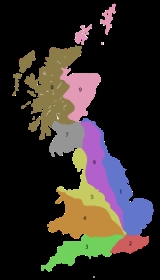
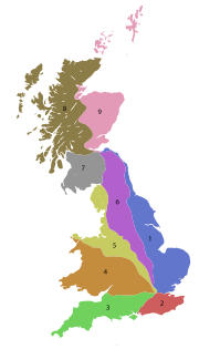
In the Great Britain road numbering scheme
, Great Britain is divided into numbered zones, the boundaries of which are usually defined by single-digit roads. The first digit of a road's number should be the number of the zone it occupies. If the road occupies multiple zones, then the furthest-anticlockwise zone is the correct one.
The following table lists all British roads which are anomalously numbered. Roads in bold lie completely outside of the "correct" zone; all other roads run for some length in the "correct" zones but trespass into zones anticlockwise of this zone.
While the M25
may appear to contradict these rules as it runs through all the London-bound zones, it in fact does not; it does not run in a complete circle, starting in Zone 2, and proceeding clockwise through zones 3, 4 and 1. The A282
, which completes the circle mostly formed by the M25, is incorrectly numbered; it proceeds into the A-road 1-zone incorrectly.
Great Britain road numbering scheme
The Great Britain road numbering scheme is a numbering scheme used to classify and identify all roads in Great Britain. Each road is given a single letter, which represents the road's category, and a subsequent number, with a length of between 1 and 4 digits. Originally introduced to arrange...
, Great Britain is divided into numbered zones, the boundaries of which are usually defined by single-digit roads. The first digit of a road's number should be the number of the zone it occupies. If the road occupies multiple zones, then the furthest-anticlockwise zone is the correct one.
The following table lists all British roads which are anomalously numbered. Roads in bold lie completely outside of the "correct" zone; all other roads run for some length in the "correct" zones but trespass into zones anticlockwise of this zone.
Motorways
Note that the motorway zone boundaries are different from the A-road boundaries shown below.| Road Number | Location | Trespassed zone(s) |
Reason |
|---|---|---|---|
| M48 M48 motorway The M48 is a motorway in Great Britain joining Gloucestershire and Monmouthshire over the original Severn Bridge. The M48 is anomalously numbered, as it is entirely to the west of the M5 motorway and its number should really therefore begin with 5.-Route:... |
Gloucestershire Gloucestershire Gloucestershire is a county in South West England. The county comprises part of the Cotswold Hills, part of the flat fertile valley of the River Severn, and the entire Forest of Dean.... , Monmouthshire Monmouthshire Monmouthshire is a county in south east Wales. The name derives from the historic county of Monmouthshire which covered a much larger area. The largest town is Abergavenny. There are many castles in Monmouthshire .-Historic county:... |
Zone 5 | This road was formerly the M4 M4 motorway The M4 motorway links London with South Wales. It is part of the unsigned European route E30. Other major places directly accessible from M4 junctions are Reading, Swindon, Bristol, Newport, Cardiff and Swansea... and links up with the A48 A48 road The A48 is a major trunk road in Great Britain. It runs from the A40 at Highnam west of Gloucester to the A40 at Carmarthen. Before the construction of the M4 motorway and the first Severn Bridge in the mid 1960s it was the principal route into South Wales. For most of its journey through Wales,... . |
| M49 M49 motorway The M49 motorway is a 5 mile motorway west of Bristol, England, that forms a shortcut between the M5 motorway and the Second Severn Bridge on the M4 motorway. It was constructed in 1996, at the same time as the bridge and is unique as it is only accessible from other motorways... |
Bristol Bristol Bristol is a city, unitary authority area and ceremonial county in South West England, with an estimated population of 433,100 for the unitary authority in 2009, and a surrounding Larger Urban Zone with an estimated 1,070,000 residents in 2007... , Gloucestershire Gloucestershire Gloucestershire is a county in South West England. The county comprises part of the Cotswold Hills, part of the flat fertile valley of the River Severn, and the entire Forest of Dean.... |
Zone 3 | This motorway lies entirely within zone 3. The motorway was constructed at the same time as the 2nd Severn Crossing, and it is likely that they used the sequential M48 and M49 for the old M4 and the new motorway respectively. |
| M62 M62 motorway The M62 motorway is a west–east trans-Pennine motorway in Northern England, connecting the cities of Liverpool and Hull via Manchester and Leeds. The road also forms part of the unsigned Euroroutes E20 and E22... |
Merseyside Merseyside Merseyside is a metropolitan county in North West England, with a population of 1,365,900. It encompasses the metropolitan area centred on both banks of the lower reaches of the Mersey Estuary, and comprises five metropolitan boroughs: Knowsley, St Helens, Sefton, Wirral, and the city of Liverpool... , Greater Manchester Greater Manchester Greater Manchester is a metropolitan county in North West England, with a population of 2.6 million. It encompasses one of the largest metropolitan areas in the United Kingdom and comprises ten metropolitan boroughs: Bolton, Bury, Oldham, Rochdale, Stockport, Tameside, Trafford, Wigan, and the... |
Zone 5 | The section from Liverpool to Manchester was planned as M52, but was added to the M62 to make a cross-country route. |
| M65 M65 motorway The M65 is a motorway in Lancashire, England. It runs from just south of Preston through the major junction of the M6 and M61 motorways, east past Darwen, Blackburn, Accrington, Burnley, Nelson and ends at Colne.-History:... |
Lancashire Lancashire Lancashire is a non-metropolitan county of historic origin in the North West of England. It takes its name from the city of Lancaster, and is sometimes known as the County of Lancaster. Although Lancaster is still considered to be the county town, Lancashire County Council is based in Preston... |
Zone 5 | The short link to the A582 is out-of-zone |
| M271 M271 motorway The M271 is a motorway near Southampton in Hampshire, England. It is long. Construction began in 1973 and it opened in 1975. It provides part of the route to Southampton Docks from the M27.-Route:... |
Hampshire Hampshire Hampshire is a county on the southern coast of England in the United Kingdom. The county town of Hampshire is Winchester, a historic cathedral city that was once the capital of England. Hampshire is notable for housing the original birthplaces of the Royal Navy, British Army, and Royal Air Force... |
Zone 3 | Numbered as a spur of the M27 M27 motorway The M27 is a motorway in Hampshire, England. It is long and runs west-east from Cadnam to Portsmouth. It was opened in stages between 1975 and 1983. It is however unfinished as an extension to the east was planned... , as opposed to the traditional numbering rules, however M3 to Southampton came after the M271 was built and may not be the zone boundary, which appears to be a straight line from M3 j8 to Exeter in some documentation |
While the M25
M25 motorway
The M25 motorway, or London Orbital, is a orbital motorway that almost encircles Greater London, England, in the United Kingdom. The motorway was first mooted early in the 20th century. A few sections, based on the now abandoned London Ringways plan, were constructed in the early 1970s and it ...
may appear to contradict these rules as it runs through all the London-bound zones, it in fact does not; it does not run in a complete circle, starting in Zone 2, and proceeding clockwise through zones 3, 4 and 1. The A282
A282 road
The A282 is a road that includes the Dartford Crossing across the River Thames between Essex and Kent in England. It forms part of the London Orbital connecting junctions 2 and 31 of the M25, and a part of the unsigned Euroroute E15. It has junctions numbered to fit inside the sequence of the M25...
, which completes the circle mostly formed by the M25, is incorrectly numbered; it proceeds into the A-road 1-zone incorrectly.
A roads
| Road Number | Location | Trespassed zone(s) |
Reason |
|---|---|---|---|
| A14 | Northamptonshire Northamptonshire Northamptonshire is a landlocked county in the English East Midlands, with a population of 629,676 as at the 2001 census. It has boundaries with the ceremonial counties of Warwickshire to the west, Leicestershire and Rutland to the north, Cambridgeshire to the east, Bedfordshire to the south-east,... |
Zone 5 & 6 | The A14 was chosen as a unique, important number for this crucial cross-country route. |
| A31 | Surrey Surrey Surrey is a county in the South East of England and is one of the Home Counties. The county borders Greater London, Kent, East Sussex, West Sussex, Hampshire and Berkshire. The historic county town is Guildford. Surrey County Council sits at Kingston upon Thames, although this has been part of... |
Zone 2 | Formerly north-east of the A3 A3 road The A3, known as the Portsmouth Road for much of its length, is a dual carriageway, or expressway, which follows the historic route between London and Portsmouth passing close to Kingston upon Thames, Guildford, Haslemere and Petersfield. For much of its length, it is classified as a trunk road... before the Guildford Bypass. |
| A42 | Leicestershire Leicestershire Leicestershire is a landlocked county in the English Midlands. It takes its name from the heavily populated City of Leicester, traditionally its administrative centre, although the City of Leicester unitary authority is today administered separately from the rest of Leicestershire... |
Zone 5 | The A42 is numbered as an extension of the M42 M42 motorway The M42 motorway is a major road in England. The motorway runs north east from Bromsgrove in Worcestershire to just south west of Ashby-de-la-Zouch in Leicestershire, passing Redditch, Solihull, the National Exhibition Centre and Tamworth on the way. The section between the M40 and M6 road forms... . |
| A51 | Warwickshire Warwickshire Warwickshire is a landlocked non-metropolitan county in the West Midlands region of England. The county town is Warwick, although the largest town is Nuneaton. The county is famous for being the birthplace of William Shakespeare... |
Zone 4 | Extended over an orphaned section of the A423 when part of that road NW of Coventry was downgraded to B class. |
| A55 | Anglesey Anglesey Anglesey , also known by its Welsh name Ynys Môn , is an island and, as Isle of Anglesey, a county off the north west coast of Wales... |
Zone 4 | The A55 supersedes the A5 through Anglesey. |
| A66 | Cumbria Cumbria Cumbria , is a non-metropolitan county in North West England. The county and Cumbria County Council, its local authority, came into existence in 1974 after the passage of the Local Government Act 1972. Cumbria's largest settlement and county town is Carlisle. It consists of six districts, and in... |
Zone 5 | The A66 was extended westwards beyond the A6 to make it a cross-country route. |
| A88 | Falkirk Falkirk Falkirk is a town in the Central Lowlands of Scotland. It lies in the Forth Valley, almost midway between the two most populous cities of Scotland; north-west of Edinburgh and north-east of Glasgow.... |
Zone 9 | Planned to extend westwards to form the A80 to Kincardine Bridge Kincardine Bridge The Kincardine Bridge is a road bridge crossing the Firth of Forth from Falkirk council area to Kincardine-on-Forth, Fife, Scotland.-History:The bridge was constructed between 1932 and 1936, designed by Donald Watson... road - this instead became the M876 M876 motorway The M876 motorway is a motorway in Scotland. The motorway runs from Denny to Airth in the Falkirk council area, forming an approach road to the Kincardine Bridge. It was opened in 1980.... . |
| A89 | Glasgow Glasgow Glasgow is the largest city in Scotland and third most populous in the United Kingdom. The city is situated on the River Clyde in the country's west central lowlands... |
Zone 7 | The A89 through Glasgow was partly formerly the A8. |
| A167 | Durham Durham Durham is a city in north east England. It is within the County Durham local government district, and is the county town of the larger ceremonial county... |
Zone 6 | The A167 through Durham was formerly part of the A1. |
| A168 A168 road The A168 is a major road in North Yorkshire, England. It runs from Northallerton to Wetherby, acting as a local access road for the A1.-History:... |
North Yorkshire North Yorkshire North Yorkshire is a non-metropolitan or shire county located in the Yorkshire and the Humber region of England, and a ceremonial county primarily in that region but partly in North East England. Created in 1974 by the Local Government Act 1972 it covers an area of , making it the largest... |
Zone 6 | The A168 originally only went from Northallerton Northallerton Northallerton is an affluent market town and civil parish in the Hambleton district of North Yorkshire, England. It lies in the Vale of Mowbray and at the northern end of the Vale of York. It has a population of 15,741 according to the 2001 census... to Dishforth Dishforth Dishforth is a village and civil parish in the Harrogate district of North Yorkshire, England. It is near RAF Dishforth, a local Army Air Corps helicopter base. The village is close to the A1 and the A168. The original route of the Great North Road runs through the village but an airbase was built... , and was extended by the former A1 when it was upgraded in 1994, changing the most Westerly point to a different zone. |
| A177 | Durham Durham Durham is a city in north east England. It is within the County Durham local government district, and is the county town of the larger ceremonial county... |
Zone 6 | In County Durham the original A1 route (now A167), not the A1(M) motorway, forms the zone boundary. |
| A181 | Durham Durham Durham is a city in north east England. It is within the County Durham local government district, and is the county town of the larger ceremonial county... |
Zone 6 | In County Durham the original A1 route (now A167), not the A1(M) motorway, forms the zone boundary. |
| A199 | East Lothian East Lothian East Lothian is one of the 32 council areas of Scotland, and a lieutenancy Area. It borders the City of Edinburgh, Scottish Borders and Midlothian. Its administrative centre is Haddington, although its largest town is Musselburgh.... |
Zone 6 | The A199 was formerly part of the A1. |
| A282 A282 road The A282 is a road that includes the Dartford Crossing across the River Thames between Essex and Kent in England. It forms part of the London Orbital connecting junctions 2 and 31 of the M25, and a part of the unsigned Euroroute E15. It has junctions numbered to fit inside the sequence of the M25... |
Thurrock Thurrock Thurrock is a unitary authority with borough status in the English ceremonial county of Essex. It is part of the London commuter belt and an area of regeneration within the Thames Gateway redevelopment zone. The local authority is Thurrock Council.... |
Zone 1 | New road which is important and assigned an A2xx number. Could be A108 or A122, both unused numbers at present. |
| A307 A307 road The A307 road is a link road running through SW London and NW Surrey, which is primary at the start but for the most part is now more local in character... |
Surrey Surrey Surrey is a county in the South East of England and is one of the Home Counties. The county borders Greater London, Kent, East Sussex, West Sussex, Hampshire and Berkshire. The historic county town is Guildford. Surrey County Council sits at Kingston upon Thames, although this has been part of... |
Zone 2 | The A307 was formerly part of the A3. |
| A320 | Surrey Surrey Surrey is a county in the South East of England and is one of the Home Counties. The county borders Greater London, Kent, East Sussex, West Sussex, Hampshire and Berkshire. The historic county town is Guildford. Surrey County Council sits at Kingston upon Thames, although this has been part of... |
Zone 2 | Formerly north-east of the A3 A3 road The A3, known as the Portsmouth Road for much of its length, is a dual carriageway, or expressway, which follows the historic route between London and Portsmouth passing close to Kingston upon Thames, Guildford, Haslemere and Petersfield. For much of its length, it is classified as a trunk road... before the Guildford Bypass. |
| A322 | Surrey Surrey Surrey is a county in the South East of England and is one of the Home Counties. The county borders Greater London, Kent, East Sussex, West Sussex, Hampshire and Berkshire. The historic county town is Guildford. Surrey County Council sits at Kingston upon Thames, although this has been part of... |
Zone 2 | Formerly north-east of the A3 A3 road The A3, known as the Portsmouth Road for much of its length, is a dual carriageway, or expressway, which follows the historic route between London and Portsmouth passing close to Kingston upon Thames, Guildford, Haslemere and Petersfield. For much of its length, it is classified as a trunk road... before the Guildford Bypass. |
| A397 | Portsmouth Portsmouth Portsmouth is the second largest city in the ceremonial county of Hampshire on the south coast of England. Portsmouth is notable for being the United Kingdom's only island city; it is located mainly on Portsea Island... |
Zone 2 | The A397 was formerly part of the A3. |
| A404 A404 road The A404 is a road in the United Kingdom that starts at Paddington in London and leads to Maidenhead in Berkshire.The road initially follows a course through London and its suburbs including Harlesden, Wembley, Harrow Pinner, and Rickmansworth... |
Windsor and Maidenhead | Zone 3 | The A404 was formerly part of the A4. |
| A412 A412 road The A412 is a road in England that links Slough and Watford. It was previously the main artery for this corridor, prior to the construction of the M25. It provides interchange to the A40/M40 at the Denham Roundabout, the M25 in Maple Cross and the A41 north of Watford... |
Slough Slough Slough is a borough and unitary authority within the ceremonial county of Royal Berkshire, England. The town straddles the A4 Bath Road and the Great Western Main Line, west of central London... |
Zone 3 | |
| A427 | Northamptonshire Northamptonshire Northamptonshire is a landlocked county in the English East Midlands, with a population of 629,676 as at the 2001 census. It has boundaries with the ceremonial counties of Warwickshire to the west, Leicestershire and Rutland to the north, Cambridgeshire to the east, Bedfordshire to the south-east,... |
Zone 6 | The A427 previously ran from Coventry to Oundle, and was truncated west of Market Harborough, when the new A14 opened. This section was renumbered as the B4027, A4303 and A4304. An even older alignment (pre-c.1960s) heading south from North Kilworth as far as the A45 is now an unclassified road (formerly B5414) and A4071. |
| A505 A505 road The A505 is an A-class road in the United Kingdom. It follows part of the route of the Icknield Way and the corresponding Icknield Way Path.-Bedfordshire:... |
Bedfordshire Bedfordshire Bedfordshire is a ceremonial county of historic origin in England that forms part of the East of England region.It borders Cambridgeshire to the north-east, Northamptonshire to the north, Buckinghamshire to the west and Hertfordshire to the south-east.... |
Zone 4 | The A505 was extended to become a cross-country route. |
| A601 | Derby Derby Derby , is a city and unitary authority in the East Midlands region of England. It lies upon the banks of the River Derwent and is located in the south of the ceremonial county of Derbyshire. In the 2001 census, the population of the city was 233,700, whilst that of the Derby Urban Area was 229,407... |
Zone 5 | Chosen as a unique number for the Derby inner ring road Ring road A ring road, orbital motorway, beltway, circumferential highway, or loop highway is a road that encircles a town or city... . |
| A605 | Cambridgeshire Cambridgeshire Cambridgeshire is a county in England, bordering Lincolnshire to the north, Norfolk to the northeast, Suffolk to the east, Essex and Hertfordshire to the south, and Bedfordshire and Northamptonshire to the west... |
Zone 1 & 4 | |
| A620 | Nottinghamshire Nottinghamshire Nottinghamshire is a county in the East Midlands of England, bordering South Yorkshire to the north-west, Lincolnshire to the east, Leicestershire to the south, and Derbyshire to the west... |
Zone 1 | The A620 was truncated and left east of the A1. |
| A624 | Chapel-en-le-Frith Chapel-en-le-Frith Chapel-en-le-Frith is a small town in Derbyshire, England, on the edge of the Peak District near the border with Cheshire, from Manchester. Dubbed "The Capital of the Peak District", the settlement was established by the Normans in the 12th century, originally as a hunting lodge within the Forest... , Derbyshire Derbyshire Derbyshire is a county in the East Midlands of England. A substantial portion of the Peak District National Park lies within Derbyshire. The northern part of Derbyshire overlaps with the Pennines, a famous chain of hills and mountains. The county contains within its boundary of approx... |
Zone 5 | The A624 was formerly part of the A6 for a short stretch in Chapel-en-le-Frith Chapel-en-le-Frith Chapel-en-le-Frith is a small town in Derbyshire, England, on the edge of the Peak District near the border with Cheshire, from Manchester. Dubbed "The Capital of the Peak District", the settlement was established by the Normans in the 12th century, originally as a hunting lodge within the Forest... before the Chapel By-pass was built. |
| A683 | Lancashire Lancashire Lancashire is a non-metropolitan county of historic origin in the North West of England. It takes its name from the city of Lancaster, and is sometimes known as the County of Lancaster. Although Lancaster is still considered to be the county town, Lancashire County Council is based in Preston... |
Zone 5 | The A683 was extended westwards to Heysham Heysham Heysham is a large coastal village near Lancaster in the county of Lancashire, England. Overlooking Morecambe Bay, it is a ferry port with services to the Isle of Man and Ireland. Heysham is the site of two nuclear power stations which are landmarks visible from hills in the surrounding area... docks. |
| A720 | Edinburgh Edinburgh Edinburgh is the capital city of Scotland, the second largest city in Scotland, and the eighth most populous in the United Kingdom. The City of Edinburgh Council governs one of Scotland's 32 local government council areas. The council area includes urban Edinburgh and a rural area... |
Zone 6 | The A720 bypasses Edinburgh, a numbering hub, making numbering difficult; A720 was chosen for apparent importance. Most important 6-zone numbers were all used. |
| A882 | Highland Highland (council area) Highland is a council area in the Scottish Highlands and is the largest local government area in both Scotland and the United Kingdom as a whole. It shares borders with the council areas of Moray, Aberdeenshire, Perth and Kinross, and Argyll and Bute. Their councils, and those of Angus and... |
Zone 9 | The A9 was rerouted to terminate at Scrabster rather than John O'Groats, leaving the A882 in zone 9. |
| A899 A899 road The A899 is a road in West Lothian, Scotland, connecting Broxburn to Livingston.It runs from the East Mains Industrial Estate, through Broxburn town centre and along to Uphall, where it turns up to the Deer Park Roundabout, where it becomes a dual carriageway running through the town of Livingston... |
West Lothian West Lothian West Lothian is one of the 32 unitary council areas in Scotland, and a Lieutenancy area. It borders the City of Edinburgh, Falkirk, North Lanarkshire, the Scottish Borders and South Lanarkshire.... |
Zone 7 | The A899 was extended south through Livingston Livingston, Scotland Livingston is a town in West Lothian, Scotland. It is the fourth post-WWII new town to be built in Scotland, designated in 1962. It is about 15 miles west of Edinburgh and 30 miles east of Glasgow, and is bordered by the towns of Broxburn to the northeast and Bathgate to the northwest.Livingston... new town New town A new town is a specific type of a planned community, or planned city, that was carefully planned from its inception and is typically constructed in a previously undeveloped area. This contrasts with settlements that evolve in a more ad hoc fashion. Land use conflicts are uncommon in new... , Scotland Scotland Scotland is a country that is part of the United Kingdom. Occupying the northern third of the island of Great Britain, it shares a border with England to the south and is bounded by the North Sea to the east, the Atlantic Ocean to the north and west, and the North Channel and Irish Sea to the... . |
| A949 A949 road The A949 classified road is in Sutherland, in the Highland area of Scotland. It has staggered junctions with the A9. From the A949 the A9 runs generally north to Thurso and generally south to Tain, Inverness, Perth, Stirling and Falkirk.... |
Highland Highland (council area) Highland is a council area in the Scottish Highlands and is the largest local government area in both Scotland and the United Kingdom as a whole. It shares borders with the council areas of Moray, Aberdeenshire, Perth and Kinross, and Argyll and Bute. Their councils, and those of Angus and... |
Zone 8 | The A949 was formerly part of the A9. |
| A1000 A1000 road The A1000 is a main road in the United Kingdom, running north from Highgate, North London for approximately to Welwyn where it joins the A1 motorway. It incorporates part of the main medieval route out of London, and runs through Finchley, Whetstone, Chipping Barnet and Monken Hadley... |
Hertfordshire Hertfordshire Hertfordshire is a ceremonial and non-metropolitan county in the East region of England. The county town is Hertford.The county is one of the Home Counties and lies inland, bordered by Greater London , Buckinghamshire , Bedfordshire , Cambridgeshire and... |
Zone 6 | The A1000 was formerly part of the A1. |
| A1057 | Hertfordshire Hertfordshire Hertfordshire is a ceremonial and non-metropolitan county in the East region of England. The county town is Hertford.The county is one of the Home Counties and lies inland, bordered by Greater London , Buckinghamshire , Bedfordshire , Cambridgeshire and... |
Zone 6 | As A1000. |
| A1068 | Northumberland Northumberland Northumberland is the northernmost ceremonial county and a unitary district in North East England. For Eurostat purposes Northumberland is a NUTS 3 region and is one of three boroughs or unitary districts that comprise the "Northumberland and Tyne and Wear" NUTS 2 region... |
Zone 6 | The A1 was rerouted around Alnwick, leaving the end of A1068 out-of-zone. |
| A1081 A1081 road The A1081 road in Hertfordshire, England broadly follows and replaces the former route of the A6 south of Luton in Bedfordshire.It runs from Luton Airport south via Harpenden to St Albans and then bears southeast via London Colney to High Barnet, where it meets the A1000 .The route was renumbered... |
Hertfordshire Hertfordshire Hertfordshire is a ceremonial and non-metropolitan county in the East region of England. The county town is Hertford.The county is one of the Home Counties and lies inland, bordered by Greater London , Buckinghamshire , Bedfordshire , Cambridgeshire and... |
Zone 6 | The A1081 was formerly part of the A6. |
| A1246 | North Yorkshire North Yorkshire North Yorkshire is a non-metropolitan or shire county located in the Yorkshire and the Humber region of England, and a ceremonial county primarily in that region but partly in North East England. Created in 1974 by the Local Government Act 1972 it covers an area of , making it the largest... |
Zone 6 | The A1246 was formerly part of the A1. |
| A3023 | Hampshire Hampshire Hampshire is a county on the southern coast of England in the United Kingdom. The county town of Hampshire is Winchester, a historic cathedral city that was once the capital of England. Hampshire is notable for housing the original birthplaces of the Royal Navy, British Army, and Royal Air Force... |
Zone 2 | |
| A3100 | Surrey Surrey Surrey is a county in the South East of England and is one of the Home Counties. The county borders Greater London, Kent, East Sussex, West Sussex, Hampshire and Berkshire. The historic county town is Guildford. Surrey County Council sits at Kingston upon Thames, although this has been part of... |
Zone 2 | The A3100 was formerly part of the A3 (and the A31). |
| A3400 | Warwickshire Warwickshire Warwickshire is a landlocked non-metropolitan county in the West Midlands region of England. The county town is Warwick, although the largest town is Nuneaton. The county is famous for being the birthplace of William Shakespeare... |
Zone 4 | The road was numbered to reflect its history as the old A34. |
| A4174 A4174 road The A4174 is a major road in England which runs around the northern and eastern edge of Bristol, mainly in South Gloucestershire, and through the southern suburbs of Bristol... |
Bristol Bristol Bristol is a city, unitary authority area and ceremonial county in South West England, with an estimated population of 433,100 for the unitary authority in 2009, and a surrounding Larger Urban Zone with an estimated 1,070,000 residents in 2007... |
Zone 3 | The A4174 is part of the Bristol outer ring road. It was originally entirely in zone 4 but has been extended to the A4 and then south of it. |
| A4208 | London London London is the capital city of :England and the :United Kingdom, the largest metropolitan area in the United Kingdom, and the largest urban zone in the European Union by most measures. Located on the River Thames, London has been a major settlement for two millennia, its history going back to its... |
Zone 3 | Truncation of the A4 left the A4208 out-of-zone. |
| A4300 | Northamptonshire Northamptonshire Northamptonshire is a landlocked county in the English East Midlands, with a population of 629,676 as at the 2001 census. It has boundaries with the ceremonial counties of Warwickshire to the west, Leicestershire and Rutland to the north, Cambridgeshire to the east, Bedfordshire to the south-east,... |
Zone 5 | The A4300 was formerly part of the A43. |
| A4303 | Leicestershire Leicestershire Leicestershire is a landlocked county in the English Midlands. It takes its name from the heavily populated City of Leicester, traditionally its administrative centre, although the City of Leicester unitary authority is today administered separately from the rest of Leicestershire... |
Zone 5 | The A4303 was formerly part of the A427. |
| A4304 | Leicestershire Leicestershire Leicestershire is a landlocked county in the English Midlands. It takes its name from the heavily populated City of Leicester, traditionally its administrative centre, although the City of Leicester unitary authority is today administered separately from the rest of Leicestershire... |
Zone 5 | As A4303. |
| A4500 | Northamptonshire Northamptonshire Northamptonshire is a landlocked county in the English East Midlands, with a population of 629,676 as at the 2001 census. It has boundaries with the ceremonial counties of Warwickshire to the west, Leicestershire and Rutland to the north, Cambridgeshire to the east, Bedfordshire to the south-east,... |
Zone 5 | The A4500 was formerly part of the A45. |
| A4501 | Northamptonshire Northamptonshire Northamptonshire is a landlocked county in the English East Midlands, with a population of 629,676 as at the 2001 census. It has boundaries with the ceremonial counties of Warwickshire to the west, Leicestershire and Rutland to the north, Cambridgeshire to the east, Bedfordshire to the south-east,... |
Zone 5 | As A4500. |
| A5127 A5127 road The A5127 is a major road in England which runs between Birmingham and Lichfield, Staffordshire. For much of the route the road follows the old route of the A38 which has since been moved in order to by-pass places such as Erdington and Sutton Coldfield and form a relief road from Birmingham city... |
Staffordshire Staffordshire Staffordshire is a landlocked county in the West Midlands region of England. For Eurostat purposes, the county is a NUTS 3 region and is one of four counties or unitary districts that comprise the "Shropshire and Staffordshire" NUTS 2 region. Part of the National Forest lies within its borders... , West Midlands West Midlands (county) The West Midlands is a metropolitan county in western central England with a 2009 estimated population of 2,638,700. It came into existence as a metropolitan county in 1974 after the passage of the Local Government Act 1972, formed from parts of Staffordshire, Worcestershire and Warwickshire. The... |
Zone 4 | The A5127 was extended south when the A38 bypassed Sutton Coldfield Sutton Coldfield Sutton Coldfield is a suburb of Birmingham, in the West Midlands of England. Sutton is located about from central Birmingham but has borders with Erdington and Kingstanding. Sutton is in the northeast of Birmingham, with a population of 105,000 recorded in the 2001 census... . |
| A5140 | Bedfordshire Bedfordshire Bedfordshire is a ceremonial county of historic origin in England that forms part of the East of England region.It borders Cambridgeshire to the north-east, Northamptonshire to the north, Buckinghamshire to the west and Hertfordshire to the south-east.... |
Zone 4 | |
| A5153 | Anglesey Anglesey Anglesey , also known by its Welsh name Ynys Môn , is an island and, as Isle of Anglesey, a county off the north west coast of Wales... |
Zone 4 | |
| A5154 | Anglesey Anglesey Anglesey , also known by its Welsh name Ynys Môn , is an island and, as Isle of Anglesey, a county off the north west coast of Wales... |
Zone 4 | |
| A5223 | Telford Telford Telford is a large new town in the borough of Telford and Wrekin and ceremonial county of Shropshire, England, approximately east of Shrewsbury, and west of Birmingham... |
Zone 4 | |
| A6004 | Leicestershire Leicestershire Leicestershire is a landlocked county in the English Midlands. It takes its name from the heavily populated City of Leicester, traditionally its administrative centre, although the City of Leicester unitary authority is today administered separately from the rest of Leicestershire... |
Zone 5 | The A6004 was formerly part of the A6. |
| A6010 | Manchester Manchester Manchester is a city and metropolitan borough in Greater Manchester, England. According to the Office for National Statistics, the 2010 mid-year population estimate for Manchester was 498,800. Manchester lies within one of the UK's largest metropolitan areas, the metropolitan county of Greater... |
Zone 5 | The A6010 is part of the Manchester ring road. |
| A6143 | Manchester Manchester Manchester is a city and metropolitan borough in Greater Manchester, England. According to the Office for National Statistics, the 2010 mid-year population estimate for Manchester was 498,800. Manchester lies within one of the UK's largest metropolitan areas, the metropolitan county of Greater... |
Zone 5 | |
| A6144 | Trafford Trafford The Metropolitan Borough of Trafford is a metropolitan borough of Greater Manchester, England. It has a population of 211,800, covers , and includes the towns of Altrincham, Partington, Sale, Stretford, and Urmston... |
Zone 5 | |
| A6182 A6182 road The A6182, or White Rose Way, is a dual carriageway that runs north from junction 3 of the M18 to approximately two miles away from Doncaster town centre.... |
Doncaster Doncaster Doncaster is a town in South Yorkshire, England, and the principal settlement of the Metropolitan Borough of Doncaster. The town is about from Sheffield and is popularly referred to as "Donny"... |
Zone 1 | The A1 was rerouted leaving the A6182 out-of-zone. |
| A8000 | Edinburgh Edinburgh Edinburgh is the capital city of Scotland, the second largest city in Scotland, and the eighth most populous in the United Kingdom. The City of Edinburgh Council governs one of Scotland's 32 local government council areas. The council area includes urban Edinburgh and a rural area... |
Zone 9 | The A8000 was truncated with the building of the M9 spur halfway to the Forth Road Bridge Forth Road Bridge The Forth Road Bridge is a suspension bridge in east central Scotland. The bridge, opened in 1964, spans the Firth of Forth, connecting the capital city Edinburgh, at South Queensferry, to Fife, at North Queensferry... . |
B roads
| Road Number | Location | Trespassed zone(s) |
Reason |
|---|---|---|---|
| B197 | Hertfordshire | Zone 6 | The B197 was formerly part of the A1 |
| B316 | London | Zone 4 | A4 rerouted |
| B325 | London | Zone 4 | A4 rerouted |
| B455 | London | Zone 3 | |
| B470 | Windsor and Maidenhead | Zone 3 | |
| B576 | Northamptonshire | Zone 6 | A6 rerouted |
| B645 | Northamptonshire | Zone 5 | A6 rerouted |
| B855 | Highland | Zone 9 | The A9 was rerouted west of this road, to end at Scrabster. |
| B876 | Highland | Zone 9 | The A9 was rerouted west of this road, to end at Scrabster. |
| B1043 | Cambridgeshire | Zone 6 | The B1043 was formerly part of the A1. |
| B1164 | Nottinghamshire | Zone 6 | The B1164 was formerly part of the A1. |
| B1198 | Durham | Zone 6 | In County Durham the original A1 route (now A167), not the A1(M) motorway, forms the zone boundary. |
| B1217 | Leeds | Zone 6 | extended along old A642 when M1 extended |
| B1224 | North Yorkshire | Zone 6 | In County Durham the original A1 route (now A167), not the A1(M) motorway, forms the zone boundary. |
| B1284 | Durham | Zone 6 | In County Durham the original A1 route (now A167), not the A1(M) motorway, forms the zone boundary. |
| B3000 | Surrey | Zone 2 | A3 rerouted |
| B3004 | Hampshire | Zone 2 | |
| B3006 | Hampshire | Zone 2 | |
| B4640 | West Berkshire | Zone 3 | |
| B4666 | Hinckley, Leicestershire | Zone 5 | The B4666 was formerly part of the A47. |
| B4667 | Hinckley, Leicestershire | Zone 5 | The B4667 was formerly part of the A447. |
| B4668 | Hinckley, Leicestershire | Zone 5 | The B4668 was formerly part of the A47. |
| B4669 | Leicestershire | Zone 5 | |
| B5060 | Telford | Zone 4 | |
| B5061 | Shropshire | Zone 4 | |
| B5070 | Wrexham | Zone 4 | The B5070 was formerly part of the A5. |
| B5072 | Telford | Zone 4 | |
| B5444 | Swansea | Zone 4 | There was previously, and still is, a B5444 in Mold Mold Molds are fungi that grow in the form of multicellular filaments called hyphae. Molds are not considered to be microbes but microscopic fungi that grow as single cells called yeasts... , suggesting this numbering is also erroneous. |
| B5477 | Shropshire | Zone 4 | This was, until renumbered in 2004, the northern section of the B4370 (Little Stretton Little Stretton, Shropshire Little Stretton is a village in Shropshire, England.It lies on the B5477 to the south of the town of Church Stretton ; similarly, the small village of All Stretton lies to the north of Church Stretton on the same road... - Church Stretton Church Stretton Church Stretton is a small town and civil parish in Shropshire, England. The population of the town was recorded as 2,789 in 2001, whilst the population of the wider parish was recorded as 4,186... - All Stretton All Stretton All Stretton is a village and civil parish in Shropshire, England.-Geography:All Stretton lies about a mile to the north of the market town of Church Stretton, on the old Shrewsbury Road - the county town is 12 miles to the north. Similarly, the small village of Little Stretton lies to the south... ). |
| B6241 | Preston, Lancashire | Zone 5 | The B6241 was extended west of the A6. |
| B6280 | Darlington | Zone 1 | In County Durham the original A1 route (now A167), not the A1(M) motorway, forms the zone boundary. |
| B6291 | Durham | Zone 1 | The original section within Zone 6 was renumbered to become an extension of the A688. |
| B6420 | Nottinghamshire | Zone 1 | The A1 was re-routed, leaving its start-point out of zone. |
| B6469 | Manchester | Zone 5 | |
| B6541 | Middlesbrough | Zone 1 | The B6541 was formerly part of the A66. |
| B7201 | Dumfries and Galloway | Zone 6 | The B7201 was formerly part of the A7 before bypass of Canonbie Canonbie Canonbie is a small village in Dumfries and Galloway in south west Scotland, six miles south of Langholm and two miles north of the Anglo-Scottish border. It is on the A7 road from Carlisle to Edinburgh, and the River Esk flows through it... ; was B720 beforehand. |
| B9080 | West Lothian | Zone 8 | The B9080 was formerly part of the A9. |
| B9150 | Highland | Zone 8 | The B9150 was formerly part of the A9. |
| B9163 | Highland | Zone 8 | A9 rerouted |
| B9164 | Highland | Zone 8 | A9 rerouted |
| B9169 | Highland | Zone 8 | A9 rerouted |
| B9176 | Highland | Zone 8 | The B9176 was formerly part of the A9 |
| B9177 | Highland | Zone 8 | The B9177 was formerly part of the A9 |
Irregularities not based on the zoning system
| Road Number | Location | Reason |
|---|---|---|
| A135 A135 road The A135 is a road in Teesside, England, running from Stockton-on-Tees through Eaglescliffe to Yarm on the A67, on the boundary with the River Tees. It is also known as Yarm Road, and was the A19 before the dual carriageway was built.... |
Stockton-on-Tees Stockton-on-Tees Stockton-on-Tees is a market town in north east England. It is the major settlement in the unitary authority and borough of Stockton-on-Tees. For ceremonial purposes, the borough is split between County Durham and North Yorkshire as it also incorporates a number of smaller towns including... |
The other A13x roads are in southern England. |
| A139 | Stockton-on-Tees Stockton-on-Tees Stockton-on-Tees is a market town in north east England. It is the major settlement in the unitary authority and borough of Stockton-on-Tees. For ceremonial purposes, the borough is split between County Durham and North Yorkshire as it also incorporates a number of smaller towns including... |
The other A13x roads are in southern England. |
| A176 | Basildon Basildon Basildon is a town located in the Basildon District of the county of Essex, England.It lies east of Central London and south of the county town of Chelmsford... , Essex Essex Essex is a ceremonial and non-metropolitan county in the East region of England, and one of the home counties. It is located to the northeast of Greater London. It borders with Cambridgeshire and Suffolk to the north, Hertfordshire to the west, Kent to the South and London to the south west... |
The other A17x roads are in North Yorkshire North Yorkshire North Yorkshire is a non-metropolitan or shire county located in the Yorkshire and the Humber region of England, and a ceremonial county primarily in that region but partly in North East England. Created in 1974 by the Local Government Act 1972 it covers an area of , making it the largest... or County Durham County Durham County Durham is a ceremonial county and unitary district in north east England. The county town is Durham. The largest settlement in the ceremonial county is the town of Darlington... . |
| A180 | Grimsby Grimsby Grimsby is a seaport on the Humber Estuary in Lincolnshire, England. It has been the administrative centre of the unitary authority area of North East Lincolnshire since 1996... |
The other A18x roads are in the North-east. The A180 is numbered as an extension of the M180 M180 motorway The M180 motorway is a short but major motorway in England from junction 5 on the M18 motorway in the Metropolitan Borough of Doncaster to a point close to Humberside Airport some from the ports of Immingham and Grimsby and the east coast and provides access for major routes to Cleethorpes,... . |
| A249 A249 road The A249 is a road in Kent, England, running from Maidstone to Sheerness on the Isle of Sheppey. It mainly functions as a link between the M2 and M20 motorways, and for goods vehicle traffic to the port at Sheerness.... |
Maidstone Maidstone Maidstone is the county town of Kent, England, south-east of London. The River Medway runs through the centre of the town linking Maidstone to Rochester and the Thames Estuary. Historically, the river was a source and route for much of the town's trade. Maidstone was the centre of the agricultural... - Sheerness Sheerness Sheerness is a town located beside the mouth of the River Medway on the northwest corner of the Isle of Sheppey in north Kent, England. With a population of 12,000 it is the largest town on the island.... , Kent Kent Kent is a county in southeast England, and is one of the home counties. It borders East Sussex, Surrey and Greater London and has a defined boundary with Essex in the middle of the Thames Estuary. The ceremonial county boundaries of Kent include the shire county of Kent and the unitary borough of... |
The other A24x roads are in Surrey. |
| A403 A403 road The A403 is a road in the United Kingdom that starts at junction 1 of the M48 at Aust and leads to Avonmouth in Bristol. It is important as a major route for the industries there, allowing easy travel access to Wales and South and East England.... |
Avonmouth Avonmouth Avonmouth is a port and suburb of Bristol, England, located on the Severn Estuary, at the mouth of the River Avon.The council ward of Avonmouth also includes Shirehampton and the western end of Lawrence Weston.- Geography :... , South Gloucestershire South Gloucestershire South Gloucestershire is a unitary district in the ceremonial county of Gloucestershire, in South West England.-History:The district was created in 1996, when the county of Avon was abolished, by the merger of former area of the districts of Kingswood and Northavon... |
The other A40x roads are in or around Greater London Greater London Greater London is the top-level administrative division of England covering London. It was created in 1965 and spans the City of London, including Middle Temple and Inner Temple, and the 32 London boroughs. This territory is coterminate with the London Government Office Region and the London... |
| A437 | Hillingdon London Borough of Hillingdon The London Borough of Hillingdon is the westernmost borough in Greater London, England. The borough's population was recorded as 243,006 in the 2001 Census. The borough incorporates the former districts of Ruislip-Northwood, Uxbridge, Hayes and Harlington and Yiewsley and West Drayton in the... , Greater London Greater London Greater London is the top-level administrative division of England covering London. It was created in 1965 and spans the City of London, including Middle Temple and Inner Temple, and the 32 London boroughs. This territory is coterminate with the London Government Office Region and the London... |
The other A43x roads are in Gloucestershire Gloucestershire Gloucestershire is a county in South West England. The county comprises part of the Cotswold Hills, part of the flat fertile valley of the River Severn, and the entire Forest of Dean.... , Oxfordshire Oxfordshire Oxfordshire is a county in the South East region of England, bordering on Warwickshire and Northamptonshire , Buckinghamshire , Berkshire , Wiltshire and Gloucestershire .... or Warwickshire Warwickshire Warwickshire is a landlocked non-metropolitan county in the West Midlands region of England. The county town is Warwick, although the largest town is Nuneaton. The county is famous for being the birthplace of William Shakespeare... . |
| A491 A491 road The A491 is an A road in Zone 4 of the Great Britain numbering scheme.-History:The road north of Oldswinford forms part of an ancient road, probably of Anglo-Saxon origin, joining the burhs of Worcester and Stafford... |
Bromsgrove Bromsgrove Bromsgrove is a town in Worcestershire, England. The town is about north east of Worcester and south west of Birmingham city centre. It had a population of 29,237 in 2001 with a small ethnic minority and is in Bromsgrove District.- History :Bromsgrove is first documented in the early 9th century... - Stourbridge Stourbridge Stourbridge is a town within the Metropolitan Borough of Dudley, in the West Midlands of England. Historically part of Worcestershire, Stourbridge was a centre of glass making, and today includes the suburbs of Amblecote, Lye, Norton, Oldswinford, Pedmore, Wollaston, Wollescote and Wordsley The... |
The other A49x roads are in North Wales. |
| A500 A500 road The A500 is a major primary A road in Staffordshire and Cheshire, England. It is dual carriageway for most of its length and connects Nantwich, junctions 16 and 15 of the M6 motorway with the city of Stoke-on-Trent... |
Stoke-on-Trent Stoke-on-Trent Stoke-on-Trent , also called The Potteries is a city in Staffordshire, England, which forms a linear conurbation almost 12 miles long, with an area of . Together with the Borough of Newcastle-under-Lyme Stoke forms The Potteries Urban Area... "D"-road |
The other A50x roads are in London, southern England and Northamptonshire Northamptonshire Northamptonshire is a landlocked county in the English East Midlands, with a population of 629,676 as at the 2001 census. It has boundaries with the ceremonial counties of Warwickshire to the west, Leicestershire and Rutland to the north, Cambridgeshire to the east, Bedfordshire to the south-east,... |
| A506 | Liverpool Liverpool Liverpool is a city and metropolitan borough of Merseyside, England, along the eastern side of the Mersey Estuary. It was founded as a borough in 1207 and was granted city status in 1880... |
The other A50x roads are in London, southern England and Northamptonshire Northamptonshire Northamptonshire is a landlocked county in the English East Midlands, with a population of 629,676 as at the 2001 census. It has boundaries with the ceremonial counties of Warwickshire to the west, Leicestershire and Rutland to the north, Cambridgeshire to the east, Bedfordshire to the south-east,... |
| A594 | one in Cumbria Cumbria Cumbria , is a non-metropolitan county in North West England. The county and Cumbria County Council, its local authority, came into existence in 1974 after the passage of the Local Government Act 1972. Cumbria's largest settlement and county town is Carlisle. It consists of six districts, and in... , one in Leicester Leicester Leicester is a city and unitary authority in the East Midlands of England, and the county town of Leicestershire. The city lies on the River Soar and at the edge of the National Forest... |
There are two A594s which are clearly separate roads. The Cumbria version predates the Leicester version. |
| A598 | Barnet London Borough of Barnet The London Borough of Barnet is a London borough in North London and forms part of Outer London. It has a population of 331,500 and covers . It borders Hertfordshire to the north and five other London boroughs: Harrow and Brent to the west, Camden and Haringey to the south-east and Enfield to the... , Greater London Greater London Greater London is the top-level administrative division of England covering London. It was created in 1965 and spans the City of London, including Middle Temple and Inner Temple, and the 32 London boroughs. This territory is coterminate with the London Government Office Region and the London... |
The other A59x roads are in Cumbria (but see A594 above) |
| A601(M) A601(M) motorway The A601 is a motorway in Lancashire, England. It is 1.1 miles long, and meets the M6 at Junction 35. It is a unique motorway within the United Kingdom as it has a dual carriageway section leading north from Junction 35 of the M6, with a single carriageway section leading south, where it... |
Carnforth Carnforth - References :... , Lancashire Lancashire Lancashire is a non-metropolitan county of historic origin in the North West of England. It takes its name from the city of Lancaster, and is sometimes known as the County of Lancaster. Although Lancaster is still considered to be the county town, Lancashire County Council is based in Preston... |
"A601(M)" would be a designation for an upgraded section of the A601. The A601 is a completely different road in Derby Derby Derby , is a city and unitary authority in the East Midlands region of England. It lies upon the banks of the River Derwent and is located in the south of the ceremonial county of Derbyshire. In the 2001 census, the population of the city was 233,700, whilst that of the Derby Urban Area was 229,407... . |
| A1042 | one in Redcar Redcar Redcar is a seaside resort in the north east of England, and a major town in the unitary authority of Redcar and Cleveland in the ceremonial county of North Yorkshire. It lies east-northeast of Middlesbrough by the North Sea coast... , one in Norwich Norwich Norwich is a city in England. It is the regional administrative centre and county town of Norfolk. During the 11th century, Norwich was the largest city in England after London, and one of the most important places in the kingdom... |
There are two A1042s which are clearly separate roads. The Redcar version predates the Norwich version. |
| A1114 | one in Chelmsford Chelmsford Chelmsford is the county town of Essex, England and the principal settlement of the borough of Chelmsford. It is located in the London commuter belt, approximately northeast of Charing Cross, London, and approximately the same distance from the once provincial Roman capital at Colchester... , one in Gateshead Gateshead Gateshead is a town in Tyne and Wear, England and is the main settlement in the Metropolitan Borough of Gateshead. Historically a part of County Durham, it lies on the southern bank of the River Tyne opposite Newcastle upon Tyne and together they form the urban core of Tyneside... |
There are two A1114s which are clearly separate roads. |
| A1199 | one in Islington Islington Islington is a neighbourhood in Greater London, England and forms the central district of the London Borough of Islington. It is a district of Inner London, spanning from Islington High Street to Highbury Fields, encompassing the area around the busy Upper Street... , one in Woodford (both in Greater London Greater London Greater London is the top-level administrative division of England covering London. It was created in 1965 and spans the City of London, including Middle Temple and Inner Temple, and the 32 London boroughs. This territory is coterminate with the London Government Office Region and the London... ) |
There are two A1199s which are clearly separate roads. |