
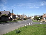
Dishforth
Encyclopedia

Civil parish
In England, a civil parish is a territorial designation and, where they are found, the lowest tier of local government below districts and counties...
in the Harrogate
Harrogate (borough)
Harrogate is a local government district and borough of North Yorkshire, England. Its council is based in the town of Harrogate but it also includes surrounding towns and villages...
district of North Yorkshire
North Yorkshire
North Yorkshire is a non-metropolitan or shire county located in the Yorkshire and the Humber region of England, and a ceremonial county primarily in that region but partly in North East England. Created in 1974 by the Local Government Act 1972 it covers an area of , making it the largest...
, England
England
England is a country that is part of the United Kingdom. It shares land borders with Scotland to the north and Wales to the west; the Irish Sea is to the north west, the Celtic Sea to the south west, with the North Sea to the east and the English Channel to the south separating it from continental...
. It is near RAF Dishforth
RAF Dishforth
Dishforth Airfield is a Royal Air Force/British Army station in North Yorkshire, England. It is currently an Army Air Corps helicopter base and a Relief Landing Ground for RAF Linton-on-Ouse. It is located next to the A1 at Junction 49 with the A168. Dishforth airfield is built over part of the...
, a local Army Air Corps helicopter base. The village
Village
A village is a clustered human settlement or community, larger than a hamlet with the population ranging from a few hundred to a few thousand , Though often located in rural areas, the term urban village is also applied to certain urban neighbourhoods, such as the West Village in Manhattan, New...
is close to the A1(M) and the A168
A168 road
The A168 is a major road in North Yorkshire, England. It runs from Northallerton to Wetherby, acting as a local access road for the A1.-History:...
. The original route of the Great North Road
Great North Road (Great Britain)
The Great North Road was a coaching route used by mail coaches between London, York and Edinburgh. The modern A1 mainly follows the Great North Road. The inns on the road, many of which survive, were staging posts on the coach routes, providing accommodation, stabling for the horses and...
runs through the village
Village
A village is a clustered human settlement or community, larger than a hamlet with the population ranging from a few hundred to a few thousand , Though often located in rural areas, the term urban village is also applied to certain urban neighbourhoods, such as the West Village in Manhattan, New...
but an airbase
Airbase
An airbase is a military airfield that provides basing and support of military aircraft....
was built over the old road which used to be the A1 and later the A167
A167 road
The A167 is a road in North East England. Most of its route was formerly the A1 as most of it is the original route of the Great North Road until the A1 was re-routed with the opening of the A1 in the 1960s....
.