
.gif)
A40 road (London)
Encyclopedia
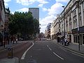
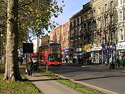
The A40 in London
is an A road in Central
and West London
. It runs from outside St. Paul's Cathedral to Fishguard
. (For the road outside London, see the main A40 road article. The London section passes through seven London Borough
s: the City of London
, Camden
, Westminster
, Kensington & Chelsea, Hammersmith & Fulham, Ealing
and Hillingdon
. The road has been re-routed several times in the last 100 years.
Much of the route of the A40 was laid out in the 1920s and 1930s when Western Avenue was built, although most of it is now grade-separated dual carriageway
. In the 1960s the Westway
was constructed, allowing traffic access to the centre of the city.
The London section of the A40 is one of London's most important roads and the most important Western Radial from London, linking the City Centre, West London Suburbs (e.g. Northolt
, Ealing
and Ruislip
) to the M40 motorway
(and M25 motorway
), and hence to Oxford
, Birmingham
and the North West of England
and North Wales
(via the M42
and M6
).
 The road officially starts at St. Martin's Le Grand
, where it shares a terminus with the A1, the main north London Radial. The A40 then forms Newgate Street
and Holborn Viaduct
, crossing the A201
leading to Blackfriars Bridge
.
At Holborn Circus
, the A40 crosses the terminus of the A4, which forms the Strand
and runs through Knightsbridge
and Hammersmith
to the M4 motorway
. The A4 is the second most important West London radial after the A40.
 The A40 then forms High Holborn
. Gray's Inn
, on the north side of the road forms one of the four Inns of Court
. Another, Lincoln's Inn
is on the road's south side. The road is now in the Borough of Camden
.
The straight alignment of the road from the Bank
all the way to Shepherds Bush made it ideal for one of London's earliest deep level tube
lines, the Central Line
. However, as the road is quite narrow, the tunnels are built above each other rather than side to side to prevent damage to building foundations. This pattern of construction can be seen at Chancery Lane
and Holborn
. The line opened originally in 1900.
 After Holborn, the A40 crosses into the City of Westminster
, forming New Oxford Street and then Oxford Street
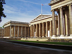
. The British Museum
is close at this point.
 Oxford Street is Europe's
busiest shopping street with many chain-stores having their flagship store on the street, including John Lewis
, Debenhams
, Marks and Spencers, House of Fraser
and Selfridges
.
Tube Stations along the road are numerous in this section, and the Central Line
, running under Oxford Street
and the A40 is London Underground's second busiest line with 180 million passengers a year. The busiest stations are Oxford Circus
, Tottenham Court Road
and Bond Street
, which provide access to five tube lines.
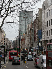
The road is also in the heart of Soho
, and although the main theatres and cinemas are located to the south (e.g. Leicester Square
) the area does contain a large number of clubs, bars and music venues, Wigmore Hall
on Wigmore Street
being a notable example. The area is also known for Centre Point
, see photograph, which was one of London's first Skyscraper
s.

 The road continues as Oxford Street
until Marble Arch
, which is at the north-east corner of Hyde Park
. Nearby is the area known as Speakers' Corner
. People are generally allowed to say what they want
, with the police being tolerant and only stepping in when the need arises. The site of Tyburn
Gallows
is also near, which was a place of public execution from 1388 to 1793.
The road around Marble Arch forms a major road junction connecting Oxford Street, Park Lane
(A4202), Bayswater Road
(A402) and Edgware Road (A5). The A40 has taken three courses from here over the last thirty years, the last change in 2000, when Westway
lost its motorway status (A40(M)) and became the A40.
 Before Western Avenue was laid out and the Westway
was completed, the A40 ran along Uxbridge Road
(the present A4020) through Ealing
and Southall
to Uxbridge
. Uxbridge Road is still a major road, passing through many retail and residential districts. A number of bus
routes travel along the road including Route 207
, Route 427
and Route 607
. Because of this, traffic is often heavy.
In 2006, a tram system was proposed called the West London Tram
, which would have run from Shepherd's Bush tube station
to Uxbridge tube station
, along Uxbridge Road. The route would have replaced the three above bus routes.
In August 2007, the scheme was 'indefinitely postponed' due to local opposition. It has been suggested though, that it still be constructed if Crossrail
does not reduce traffic.
is a 2.5 mile long elavated dual-carriageway, part of the present A40, between Paddington
and North Kensington
. It was constructed between 1964 and 1970. The road runs from the Marylebone Flyover (A501), which crosses over Edgware Road (A5 and Marylebone Road (A501). From here, it travels parallel to the Great Western Main Line
out of Paddington
, returning to ground level to join Western Avenue.
When opened in July 1970, the Westway was known as the A40(M), reflecting the motorway standard to which the road had been built. Even today, it still has hard shoulders and contains both four-lane and six-lane sections.
 The Westway opened as the 'A40(M)'. As it joined on to Western Avenue (which was already the A40, although for a time it was known as the A403), the A40 proper also had to reach the meeting point. To do this, the A40 continued along Bayswater Road
and Holland Park Avenue
(today A402), running through Notting Hill Gate
to Shepherd's Bush
, where the A40 turned north. The old route along Uxbridge Road
was subsequentially renamed as the A4020.
From there, the A40 travelled along Wood Lane
, past the BBC Television Centre
to reach the end of the Westway at a roundabout. Also terminating at this roundabout was the M41, now the A3220
, or the West Cross Route
. The M41 opened at the same time as the Westway but was downgraded to the A3220 like the A40(M) in 2000.
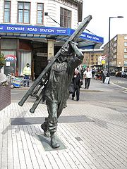 Now that the Westway is now the A40 itself, the A40 at Marble Arch has to reach the Marylebone Flyover to join the Westway. To do this, it leaves its old route at the Marble Arch roundabout. It now travels with the A5 up Edgware Road to Marylebone Road (the road is just signposted as the A5, not the A5 and A40). At Marylebone Road, the two roads part; the A40 becomes the Westway and the A5 continues as Edgware Road.
through which climbs up from Marylebone Road
(A501) passing Paddington Basin
and Paddington station
and crossing the Paddington Branch of the Grand Union Canal
. It then follows the Hammersmith & City line
through North Kensington
and Westbourne Green
passing three London Underground
stations (Royal Oak
, Westbourne Park
and Ladbroke Grove
). It then passes over a roundabout junction with the West Cross Route
(former M41 motorway, now A3220
) and a junction with the A219
before flowing into Western Avenue.
The construction of the road lasted between 1964 and 1970 and caused huge disruption, involving the demolition of both houses and roads. When opened it was the largest continuous concrete structure in Britain.
London
London is the capital city of :England and the :United Kingdom, the largest metropolitan area in the United Kingdom, and the largest urban zone in the European Union by most measures. Located on the River Thames, London has been a major settlement for two millennia, its history going back to its...
is an A road in Central
Central London
Central London is the innermost part of London, England. There is no official or commonly accepted definition of its area, but its characteristics are understood to include a high density built environment, high land values, an elevated daytime population and a concentration of regionally,...
and West London
West (London sub region)
The West is a sub-region of the London Plan corresponding to the London Boroughs of Brent, Ealing, Hammersmith and Fulham, Harrow, Hillingdon and Hounslow. The sub region was established in 2004 and was adjusted in 2008 to include Kensington and Chelsea. The west has a population of 1.6 million and...
. It runs from outside St. Paul's Cathedral to Fishguard
Fishguard
Fishguard is a coastal town in Pembrokeshire, south-west Wales, with a population of 3,300 . The community of Fishguard and Goodwick had a population of 5043 at the 2001 census....
. (For the road outside London, see the main A40 road article. The London section passes through seven London Borough
London borough
The administrative area of Greater London contains thirty-two London boroughs. Inner London comprises twelve of these boroughs plus the City of London. Outer London comprises the twenty remaining boroughs of Greater London.-Functions:...
s: the City of London
City of London
The City of London is a small area within Greater London, England. It is the historic core of London around which the modern conurbation grew and has held city status since time immemorial. The City’s boundaries have remained almost unchanged since the Middle Ages, and it is now only a tiny part of...
, Camden
London Borough of Camden
In 1801, the civil parishes that form the modern borough were already developed and had a total population of 96,795. This continued to rise swiftly throughout the 19th century, as the district became built up; reaching 270,197 in the middle of the century...
, Westminster
City of Westminster
The City of Westminster is a London borough occupying much of the central area of London, England, including most of the West End. It is located to the west of and adjoining the ancient City of London, directly to the east of the Royal Borough of Kensington and Chelsea, and its southern boundary...
, Kensington & Chelsea, Hammersmith & Fulham, Ealing
London Borough of Ealing
The London Borough of Ealing is a borough in west London.-Location:The London Borough of Ealing borders the London Borough of Hillingdon to the west, the London Borough of Harrow and the London Borough of Brent to the north, the London Borough of Hammersmith and Fulham to the east and the London...
and Hillingdon
London Borough of Hillingdon
The London Borough of Hillingdon is the westernmost borough in Greater London, England. The borough's population was recorded as 243,006 in the 2001 Census. The borough incorporates the former districts of Ruislip-Northwood, Uxbridge, Hayes and Harlington and Yiewsley and West Drayton in the...
. The road has been re-routed several times in the last 100 years.
Much of the route of the A40 was laid out in the 1920s and 1930s when Western Avenue was built, although most of it is now grade-separated dual carriageway
Dual carriageway
A dual carriageway is a class of highway with two carriageways for traffic travelling in opposite directions separated by a central reservation...
. In the 1960s the Westway
Westway (London)
The Westway is a long elevated dual carriageway section of the A40 route in west London running from Paddington to North Kensington. The road was constructed between 1964 and 1970 to relieve congestion at Shepherd's Bush caused by traffic from Western Avenue struggling to enter central London on...
was constructed, allowing traffic access to the centre of the city.
The London section of the A40 is one of London's most important roads and the most important Western Radial from London, linking the City Centre, West London Suburbs (e.g. Northolt
Northolt
Northolt is a town in the London Borough of Ealing, England. The town has London Underground and Network Rail stations and is on the A40 road...
, Ealing
Ealing
Ealing is a suburban area of west London, England and the administrative centre of the London Borough of Ealing. It is located west of Charing Cross and around from the City of London. It is one of the major metropolitan centres identified in the London Plan. It was historically a rural village...
and Ruislip
Ruislip
Ruislip is a suburban area, centred on an old village in Greater London, and is part of the London Borough of Hillingdon.It was formerly also a parish covering the neighbouring areas of Eastcote, Northwood, Ruislip Manor and South Ruislip in the area. The parish appears in the Domesday Book, and...
) to the M40 motorway
M40 motorway
The M40 motorway is a motorway in the British transport network that forms a major part of the connection between London and Birmingham. Part of this road forms a section of the unsigned European route E05...
(and M25 motorway
M25 motorway
The M25 motorway, or London Orbital, is a orbital motorway that almost encircles Greater London, England, in the United Kingdom. The motorway was first mooted early in the 20th century. A few sections, based on the now abandoned London Ringways plan, were constructed in the early 1970s and it ...
), and hence to Oxford
Oxford
The city of Oxford is the county town of Oxfordshire, England. The city, made prominent by its medieval university, has a population of just under 165,000, with 153,900 living within the district boundary. It lies about 50 miles north-west of London. The rivers Cherwell and Thames run through...
, Birmingham
Birmingham
Birmingham is a city and metropolitan borough in the West Midlands of England. It is the most populous British city outside the capital London, with a population of 1,036,900 , and lies at the heart of the West Midlands conurbation, the second most populous urban area in the United Kingdom with a...
and the North West of England
North West England
North West England, informally known as The North West, is one of the nine official regions of England.North West England had a 2006 estimated population of 6,853,201 the third most populated region after London and the South East...
and North Wales
North Wales
North Wales is the northernmost unofficial region of Wales. It is bordered to the south by the counties of Ceredigion and Powys in Mid Wales and to the east by the counties of Shropshire in the West Midlands and Cheshire in North West England...
(via the M42
M42 motorway
The M42 motorway is a major road in England. The motorway runs north east from Bromsgrove in Worcestershire to just south west of Ashby-de-la-Zouch in Leicestershire, passing Redditch, Solihull, the National Exhibition Centre and Tamworth on the way. The section between the M40 and M6 road forms...
and M6
M6 motorway
The M6 motorway runs from junction 19 of the M1 at the Catthorpe Interchange, near Rugby via Birmingham then heads north, passing Stoke-on-Trent, Manchester, Preston, Carlisle and terminating at the Gretna junction . Here, just short of the Scottish border it becomes the A74 which continues to...
).
City of London
St. Martin's Le Grand
St Martin’s le Grand is a street and former liberty in the City of London between Newgate Street and Cheapside to the south and Aldersgate Street and London Wall to the north. To the east of the road once stood the collegiate church and monastic precinct of St Martin's, of ancient origin...
, where it shares a terminus with the A1, the main north London Radial. The A40 then forms Newgate Street
Newgate Street
Newgate Street refers to:*Newgate and Newgate Street in London*Newgate Street, Hertfordshire, a village in Hertfordshire*Newgate Street, Newcastle, a shopping and entertainment street in Newcastle upon Tyne...
and Holborn Viaduct
Holborn Viaduct
Holborn Viaduct is a bridge in London and the name of the street which crosses it . It links Holborn, via Holborn Circus, with Newgate Street in the City of London, passing over Farringdon Street and the now subterranean River Fleet.It was built between 1863 and 1869, at a cost of over two million...
, crossing the A201
A201 road
The A201 is an A road in London running from Kings Cross to the Elephant and Castle.The route passes along Kings Cross Road, Farringdon Road, Farringdon Street, New Bridge Street, Blackfriars Bridge, Blackfriars Road, London Road to the Elephant and Castle, and finally New Kent Road where it merges...
leading to Blackfriars Bridge
Blackfriars Bridge
Blackfriars Bridge is a road and foot traffic bridge over the River Thames in London, between Waterloo Bridge and Blackfriars Railway Bridge, carrying the A201 road. The north end is near the Inns of Court and Temple Church, along with Blackfriars station...
.
At Holborn Circus
Holborn Circus
Holborn Circus is a famous location in London, on the boundary between Holborn and Smithfield. Holborn Circus is a roundabout.On one side lies the Church of St Andrew, Holborn, an ancient Guild Church, that survived the Great Fire of London. However, the parochial authority decided, nevertheless,...
, the A40 crosses the terminus of the A4, which forms the Strand
Strand, London
Strand is a street in the City of Westminster, London, England. The street is just over three-quarters of a mile long. It currently starts at Trafalgar Square and runs east to join Fleet Street at Temple Bar, which marks the boundary of the City of London at this point, though its historical length...
and runs through Knightsbridge
Knightsbridge
Knightsbridge is a road which gives its name to an exclusive district lying to the west of central London. The road runs along the south side of Hyde Park, west from Hyde Park Corner, spanning the City of Westminster and the Royal Borough of Kensington and Chelsea...
and Hammersmith
Hammersmith
Hammersmith is an urban centre in the London Borough of Hammersmith and Fulham in west London, England, in the United Kingdom, approximately five miles west of Charing Cross on the north bank of the River Thames...
to the M4 motorway
M4 motorway
The M4 motorway links London with South Wales. It is part of the unsigned European route E30. Other major places directly accessible from M4 junctions are Reading, Swindon, Bristol, Newport, Cardiff and Swansea...
. The A4 is the second most important West London radial after the A40.
Holborn and Oxford Street
Holborn
Holborn is an area of Central London. Holborn is also the name of the area's principal east-west street, running as High Holborn from St Giles's High Street to Gray's Inn Road and then on to Holborn Viaduct...
. Gray's Inn
Gray's Inn
The Honourable Society of Gray's Inn, commonly known as Gray's Inn, is one of the four Inns of Court in London. To be called to the Bar and practise as a barrister in England and Wales, an individual must belong to one of these Inns...
, on the north side of the road forms one of the four Inns of Court
Inns of Court
The Inns of Court in London are the professional associations for barristers in England and Wales. All such barristers must belong to one such association. They have supervisory and disciplinary functions over their members. The Inns also provide libraries, dining facilities and professional...
. Another, Lincoln's Inn
Lincoln's Inn
The Honourable Society of Lincoln's Inn is one of four Inns of Court in London to which barristers of England and Wales belong and where they are called to the Bar. The other three are Middle Temple, Inner Temple and Gray's Inn. Although Lincoln's Inn is able to trace its official records beyond...
is on the road's south side. The road is now in the Borough of Camden
London Borough of Camden
In 1801, the civil parishes that form the modern borough were already developed and had a total population of 96,795. This continued to rise swiftly throughout the 19th century, as the district became built up; reaching 270,197 in the middle of the century...
.
The straight alignment of the road from the Bank
Bank of England
The Bank of England is the central bank of the United Kingdom and the model on which most modern central banks have been based. Established in 1694, it is the second oldest central bank in the world...
all the way to Shepherds Bush made it ideal for one of London's earliest deep level tube
London Underground
The London Underground is a rapid transit system serving a large part of Greater London and some parts of Buckinghamshire, Hertfordshire and Essex in England...
lines, the Central Line
Central Line
The Central line is a London Underground line, coloured red on the tube map. It is a deep-level "tube" line, running east-west across London, and, at , has the greatest total length of track of any line on the Underground. Of the 49 stations served, 20 are below ground...
. However, as the road is quite narrow, the tunnels are built above each other rather than side to side to prevent damage to building foundations. This pattern of construction can be seen at Chancery Lane
Chancery Lane tube station
Chancery Lane is a London Underground station in central London. It is on the Central Line between St. Paul's and Holborn stations. The station is located at the junction of High Holborn, Hatton Garden and Gray's Inn Road with subway entrances giving access to the ticket office under the roadway...
and Holborn
Holborn tube station
Holborn is a station of the London Underground in Holborn in London, located at the junction of High Holborn and Kingsway. Situated on the Piccadilly Line and on the Central Line , it is the only station common to the two lines, although the two lines cross each other three times elsewhere...
. The line opened originally in 1900.
City of Westminster
The City of Westminster is a London borough occupying much of the central area of London, England, including most of the West End. It is located to the west of and adjoining the ancient City of London, directly to the east of the Royal Borough of Kensington and Chelsea, and its southern boundary...
, forming New Oxford Street and then Oxford Street
Oxford Street
Oxford Street is a major thoroughfare in the City of Westminster in the West End of London, United Kingdom. It is Europe's busiest shopping street, as well as its most dense, and currently has approximately 300 shops. The street was formerly part of the London-Oxford road which began at Newgate,...
. The British Museum
British Museum
The British Museum is a museum of human history and culture in London. Its collections, which number more than seven million objects, are amongst the largest and most comprehensive in the world and originate from all continents, illustrating and documenting the story of human culture from its...
is close at this point.
Europe
Europe is, by convention, one of the world's seven continents. Comprising the westernmost peninsula of Eurasia, Europe is generally 'divided' from Asia to its east by the watershed divides of the Ural and Caucasus Mountains, the Ural River, the Caspian and Black Seas, and the waterways connecting...
busiest shopping street with many chain-stores having their flagship store on the street, including John Lewis
John Lewis (department store)
-Recent developments:In June 2004, John Lewis announced plans to open its first store in Northern Ireland at the Sprucefield Park development, the province's largest out of town shopping centre, located outside Lisburn and from Belfast. The application was approved in June 2005 and the opening of...
, Debenhams
Debenhams
Debenhams plc is a British retailer operating under a department store format in the UK, Ireland and Denmark, and franchise stores in other countries. The Company was founded in the eighteenth century as a single store in London and has now grown to around 160 shops...
, Marks and Spencers, House of Fraser
House of Fraser
House of Fraser is a British department store group with over 60 stores across the United Kingdom and Ireland. It was established in Glasgow, Scotland in 1849 as Arthur and Fraser. By 1891 it was known as Fraser & Sons. The company grew steadily during the early 20th century, but after the Second...
and Selfridges
Selfridges
Selfridges, AKA Selfridges & Co, is a chain of high end department stores in the United Kingdom. It was founded by Harry Gordon Selfridge. The flagship store in London's Oxford Street is the second largest shop in the UK and was opened on 15 March 1909.More recently, three other stores have been...
.
Tube Stations along the road are numerous in this section, and the Central Line
Central Line
The Central line is a London Underground line, coloured red on the tube map. It is a deep-level "tube" line, running east-west across London, and, at , has the greatest total length of track of any line on the Underground. Of the 49 stations served, 20 are below ground...
, running under Oxford Street
Oxford Street
Oxford Street is a major thoroughfare in the City of Westminster in the West End of London, United Kingdom. It is Europe's busiest shopping street, as well as its most dense, and currently has approximately 300 shops. The street was formerly part of the London-Oxford road which began at Newgate,...
and the A40 is London Underground's second busiest line with 180 million passengers a year. The busiest stations are Oxford Circus
Oxford Circus tube station
-External links:* ** ** * Plans of the station after the Victoria Line works , , *...
, Tottenham Court Road
Tottenham Court Road tube station
Tottenham Court Road is a London Underground station in central London. It is an interchange between the Central line and the branch of the Northern line.On the Central line it is between and , and on the Northern line it is between and...
and Bond Street
Bond Street tube station
Bond Street tube station is a London Underground station on Oxford Street, near the junction with New Bond Street. Note that the street-level entrances are approximately 200 metres west of New Bond Street itself...
, which provide access to five tube lines.
The road is also in the heart of Soho
Soho
Soho is an area of the City of Westminster and part of the West End of London. Long established as an entertainment district, for much of the 20th century Soho had a reputation for sex shops as well as night life and film industry. Since the early 1980s, the area has undergone considerable...
, and although the main theatres and cinemas are located to the south (e.g. Leicester Square
Leicester Square
Leicester Square is a pedestrianised square in the West End of London, England. The Square lies within an area bound by Lisle Street, to the north; Charing Cross Road, to the east; Orange Street, to the south; and Whitcomb Street, to the west...
) the area does contain a large number of clubs, bars and music venues, Wigmore Hall
Wigmore Hall
Wigmore Hall is a leading international recital venue that specialises in hosting performances of chamber music and is best known for classical recitals of piano, song and instrumental music. It is located at 36 Wigmore Street, London, UK and was built to provide London with a venue that was both...
on Wigmore Street
Wigmore Street
Wigmore Street is a street in the City of Westminster, in the West End of London, England. The street runs for about 600 yards parallel and to the north of Oxford Street between Portman Square to the west and Cavendish Square to the east....
being a notable example. The area is also known for Centre Point
Centre Point
Centre Point is a substantial concrete and glass office building in central London, England, occupying 101-103 New Oxford Street, WC1, close to St Giles Circus and almost directly above Tottenham Court Road tube station. The site was once occupied by a gallows...
, see photograph, which was one of London's first Skyscraper
Skyscraper
A skyscraper is a tall, continuously habitable building of many stories, often designed for office and commercial use. There is no official definition or height above which a building may be classified as a skyscraper...
s.
Marylebone and Westway
Oxford Street
Oxford Street is a major thoroughfare in the City of Westminster in the West End of London, United Kingdom. It is Europe's busiest shopping street, as well as its most dense, and currently has approximately 300 shops. The street was formerly part of the London-Oxford road which began at Newgate,...
until Marble Arch
Marble Arch
Marble Arch is a white Carrara marble monument that now stands on a large traffic island at the junction of Oxford Street, Park Lane, and Edgware Road, almost directly opposite Speakers' Corner in Hyde Park in London, England...
, which is at the north-east corner of Hyde Park
Hyde Park, London
Hyde Park is one of the largest parks in central London, United Kingdom, and one of the Royal Parks of London, famous for its Speakers' Corner.The park is divided in two by the Serpentine...
. Nearby is the area known as Speakers' Corner
Speakers' Corner
A Speakers' Corner is an area where open-air public speaking, debate and discussion are allowed. The original and most noted is in the north-east corner of Hyde Park in London, United Kingdom. Speakers there may speak on any subject, as long as the police consider their speeches lawful, although...
. People are generally allowed to say what they want
Freedom of speech
Freedom of speech is the freedom to speak freely without censorship. The term freedom of expression is sometimes used synonymously, but includes any act of seeking, receiving and imparting information or ideas, regardless of the medium used...
, with the police being tolerant and only stepping in when the need arises. The site of Tyburn
Tyburn, London
Tyburn was a village in the county of Middlesex close to the current location of Marble Arch in present-day London. It took its name from the Tyburn or Teo Bourne 'boundary stream', a tributary of the River Thames which is now completely covered over between its source and its outfall into the...
Gallows
Gallows
A gallows is a frame, typically wooden, used for execution by hanging, or by means to torture before execution, as was used when being hanged, drawn and quartered...
is also near, which was a place of public execution from 1388 to 1793.
The road around Marble Arch forms a major road junction connecting Oxford Street, Park Lane
Park Lane (road)
Park Lane is a major road in the City of Westminster, in Central London.-History:Originally a country lane running north-south along what is now the eastern boundary of Hyde Park, it became a fashionable residential address from the eighteenth century onwards, offering both views across Hyde Park...
(A4202), Bayswater Road
Bayswater Road
Bayswater Road is the main road running across the north of Hyde Park, London. To the east Bayswater Road becomes Oxford Street . It is where the fictional upper middle class Forsyte family live in the BBC series the Forsyte Saga...
(A402) and Edgware Road (A5). The A40 has taken three courses from here over the last thirty years, the last change in 2000, when Westway
Westway
Westway may refer to:* Westway , a highway in London* Westway a proposed but unbuilt highway* Westway , a BBC World Service soap opera* Westway , a British TV series made in 1976* Westway, Texas...
lost its motorway status (A40(M)) and became the A40.
Pre Western Avenue
Westway (London)
The Westway is a long elevated dual carriageway section of the A40 route in west London running from Paddington to North Kensington. The road was constructed between 1964 and 1970 to relieve congestion at Shepherd's Bush caused by traffic from Western Avenue struggling to enter central London on...
was completed, the A40 ran along Uxbridge Road
Uxbridge Road
Uxbridge Road is the name of the A4020 road in London. It starts at Shepherd's Bush Green and goes west towards Uxbridge. It passes through Acton, Ealing Broadway and Hanwell....
(the present A4020) through Ealing
Ealing
Ealing is a suburban area of west London, England and the administrative centre of the London Borough of Ealing. It is located west of Charing Cross and around from the City of London. It is one of the major metropolitan centres identified in the London Plan. It was historically a rural village...
and Southall
Southall
Southall is a large suburban district of west London, England, and part of the London Borough of Ealing. It is situated west of Charing Cross. Neighbouring places include Yeading, Hayes, Hanwell, Heston, Hounslow, Greenford and Northolt...
to Uxbridge
Uxbridge
Uxbridge is a large town located in north west London, England and is the administrative headquarters of the London Borough of Hillingdon. It forms part of the ceremonial county of Greater London. It is located west-northwest of Charing Cross and is one of the major metropolitan centres...
. Uxbridge Road is still a major road, passing through many retail and residential districts. A number of bus
London Buses
London Buses is the subsidiary of Transport for London that manages bus services within Greater London, UK. Buses are required to carry similar red colour schemes and conform to the same fare scheme...
routes travel along the road including Route 207
London Buses route 207
London Buses route 207 is a Transport for London contracted bus route in London, United Kingdom. The service is currently contracted to First Centrewest.-History:...
, Route 427
London Buses route 427
London Buses route 427 is a Transport for London contracted bus route in London, United Kingdom. The service is currently contracted to First Centrewest.-History:...
and Route 607
London Buses route 607
London Buses route 607 is a Transport for London contracted bus route in London, United Kingdom. The service is currently contracted to First Centrewest.-History:...
. Because of this, traffic is often heavy.
In 2006, a tram system was proposed called the West London Tram
West London Tram
The West London Tram was a proposed on-street light rail line which was to run along the Uxbridge Road corridor in west London, England. The scheme was promoted by Transport for London but opposed by the councils of all three London Boroughs through which it would run...
, which would have run from Shepherd's Bush tube station
Shepherd's Bush tube station (Central Line)
Shepherd's Bush is a London Underground station in the district of Shepherd's Bush, which is located in west London, England, United Kingdom. The station is on the Central Line, between and stations, and it lies in Travelcard Zone 2....
to Uxbridge tube station
Uxbridge tube station
Uxbridge is a London Underground station in Uxbridge in the London Borough of Hillingdon, north-west London. The station is the terminus of the Uxbridge branches of both the Metropolitan Line and the Piccadilly Line. The next station towards London is Hillingdon. The station is 15.5 miles west of...
, along Uxbridge Road. The route would have replaced the three above bus routes.
In August 2007, the scheme was 'indefinitely postponed' due to local opposition. It has been suggested though, that it still be constructed if Crossrail
Crossrail
Crossrail is a project to build a major new railway link under central London. The name refers to the first of two routes which are the responsibility of Crossrail Ltd. It is based on an entirely new east-west tunnel with a central section from to Liverpool Street station...
does not reduce traffic.
Westway
The WestwayWestway (London)
The Westway is a long elevated dual carriageway section of the A40 route in west London running from Paddington to North Kensington. The road was constructed between 1964 and 1970 to relieve congestion at Shepherd's Bush caused by traffic from Western Avenue struggling to enter central London on...
is a 2.5 mile long elavated dual-carriageway, part of the present A40, between Paddington
Paddington
Paddington is a district within the City of Westminster, in central London, England. Formerly a metropolitan borough, it was integrated with Westminster and Greater London in 1965...
and North Kensington
North Kensington
North Kensington is an area of west London lying north of Notting Hill Gate and south of Harrow Road.North Kensington is the key neighbourhood of Notting Hill...
. It was constructed between 1964 and 1970. The road runs from the Marylebone Flyover (A501), which crosses over Edgware Road (A5 and Marylebone Road (A501). From here, it travels parallel to the Great Western Main Line
Great Western Main Line
The Great Western Main Line is a main line railway in Great Britain that runs westwards from London Paddington station to the west of England and South Wales. The core Great Western Main Line runs from London Paddington to Temple Meads railway station in Bristol. A major branch of the Great...
out of Paddington
Paddington station
Paddington railway station, also known as London Paddington, is a central London railway terminus and London Underground complex.The site is a historic one, having served as the London terminus of the Great Western Railway and its successors since 1838. Much of the current mainline station dates...
, returning to ground level to join Western Avenue.
When opened in July 1970, the Westway was known as the A40(M), reflecting the motorway standard to which the road had been built. Even today, it still has hard shoulders and contains both four-lane and six-lane sections.
Wood Lane
Bayswater Road
Bayswater Road is the main road running across the north of Hyde Park, London. To the east Bayswater Road becomes Oxford Street . It is where the fictional upper middle class Forsyte family live in the BBC series the Forsyte Saga...
and Holland Park Avenue
Holland Park
Holland Park is a district and a public park in the Royal Borough of Kensington and Chelsea, in west central London, England.Holland Park has a reputation as an affluent and fashionable area, known for attractive large Victorian townhouses, and high-class shopping and restaurants...
(today A402), running through Notting Hill Gate
Notting Hill Gate
Notting Hill Gate is one of the main thoroughfares of Notting Hill, in the Royal Borough of Kensington and Chelsea. Historically the street was a location for toll gates, from which it derives its modern name.- Location :...
to Shepherd's Bush
Shepherd's Bush
-Commerce:Commercial activity in Shepherd's Bush is now focused on the Westfield shopping centre next to Shepherd's Bush Central line station and on the many small shops which run along the northern side of the Green....
, where the A40 turned north. The old route along Uxbridge Road
Uxbridge Road
Uxbridge Road is the name of the A4020 road in London. It starts at Shepherd's Bush Green and goes west towards Uxbridge. It passes through Acton, Ealing Broadway and Hanwell....
was subsequentially renamed as the A4020.
From there, the A40 travelled along Wood Lane
Wood Lane
Wood Lane is a street in London. It runs north from Shepherd's Bush, under the Westway past Wormwood Scrubs where it meets Scrubs Lane. The road is wholly in the London Borough of Hammersmith and Fulham...
, past the BBC Television Centre
BBC Television Centre
BBC Television Centre at White City in West London is the headquarters of BBC Television. Officially opened on 29 June 1960, it remains one of the largest to this day; having featured over the years as backdrop to many BBC programmes, it is one of the most readily recognisable such facilities...
to reach the end of the Westway at a roundabout. Also terminating at this roundabout was the M41, now the A3220
A3220 road
The A3220 is a primary A road in London. It runs north from Clapham Common to the A40 Westway at Ladbroke Grove.The road crosses the River Thames at Battersea Bridge and from this point until its end it forms the western boundary of the London Congestion Charge zone...
, or the West Cross Route
West Cross Route
The West Cross Route is a short, dual carriageway section of the A3220 route in central London in The Royal Borough of Kensington and Chelsea, with a small part being shared with borderlining borough Hammersmith and Fulham. It runs north-south between the northern elevated roundabout junction...
. The M41 opened at the same time as the Westway but was downgraded to the A3220 like the A40(M) in 2000.
2000- present
Present day
The A40 now follows the WestwayWestway (London)
The Westway is a long elevated dual carriageway section of the A40 route in west London running from Paddington to North Kensington. The road was constructed between 1964 and 1970 to relieve congestion at Shepherd's Bush caused by traffic from Western Avenue struggling to enter central London on...
through which climbs up from Marylebone Road
Marylebone Road
Marylebone Road is an important thoroughfare in central London, within the City of Westminster. It runs east-west from the Euston Road at Regent's Park to the A40 Westway at Paddington...
(A501) passing Paddington Basin
Paddington Basin
Paddington Basin is an area of Paddington, London named after the nearby canal basin.The junction of the Regent's Canal and the Grand Junction Canal is close to this point but the basin itself is the terminus of the Paddington Arm of the Grand Junction Canal. It was opened in 1801...
and Paddington station
Paddington station
Paddington railway station, also known as London Paddington, is a central London railway terminus and London Underground complex.The site is a historic one, having served as the London terminus of the Great Western Railway and its successors since 1838. Much of the current mainline station dates...
and crossing the Paddington Branch of the Grand Union Canal
Grand Union Canal
The Grand Union Canal in England is part of the British canal system. Its main line connects London and Birmingham, stretching for 137 miles with 166 locks...
. It then follows the Hammersmith & City line
Hammersmith & City Line
The Hammersmith & City line is a subsurface London Underground line. It connects Hammersmith in the west with Barking in the east, running through the northern part of central London. It is coloured salmon pink on the Tube map...
through North Kensington
North Kensington
North Kensington is an area of west London lying north of Notting Hill Gate and south of Harrow Road.North Kensington is the key neighbourhood of Notting Hill...
and Westbourne Green
Westbourne Green
Westbourne Green is an area of London on the western edge of the City of Westminster.-Transport and locale:Nearby places*Paddington*Notting Hill*Bayswater*Warwick Avenue...
passing three London Underground
London Underground
The London Underground is a rapid transit system serving a large part of Greater London and some parts of Buckinghamshire, Hertfordshire and Essex in England...
stations (Royal Oak
Royal Oak tube station
Royal Oak tube station is a station of the London Underground, on the Hammersmith & City and Circle lines, between and stations. The station is on Lord Hills Bridge and is in Travelcard Zone 2 for the London Underground. Although not heavily used at other times, the station is extremely busy...
, Westbourne Park
Westbourne Park tube station
Westbourne Park is a London Underground station on the Circle and Hammersmith and City lines, between Ladbroke Grove and Royal Oak stations, and in Travelcard Zone 2 in The Royal Borough of Kensington and Chelsea . Although the Metropolitan Railway had been extended to Notting Hill and Hammersmith...
and Ladbroke Grove
Ladbroke Grove tube station
Ladbroke Grove is a London Underground station on the Circle and Hammersmith & City lines, between Latimer Road and Westbourne Park stations, and in Travelcard Zone 2 set in The Royal Borough of Kensington and Chelsea ....
). It then passes over a roundabout junction with the West Cross Route
West Cross Route
The West Cross Route is a short, dual carriageway section of the A3220 route in central London in The Royal Borough of Kensington and Chelsea, with a small part being shared with borderlining borough Hammersmith and Fulham. It runs north-south between the northern elevated roundabout junction...
(former M41 motorway, now A3220
A3220 road
The A3220 is a primary A road in London. It runs north from Clapham Common to the A40 Westway at Ladbroke Grove.The road crosses the River Thames at Battersea Bridge and from this point until its end it forms the western boundary of the London Congestion Charge zone...
) and a junction with the A219
A219 road
The A219, is a road in West London, England, which connects the A404 Harrow Road in Harlesden to the A24 in South Wimbledon. Running from North to South, it starts near Willesden Junction station, crosses the Grand Union Canal and runs through Shepherd's Bush, Hammersmith and Fulham, crossing the...
before flowing into Western Avenue.
The construction of the road lasted between 1964 and 1970 and caused huge disruption, involving the demolition of both houses and roads. When opened it was the largest continuous concrete structure in Britain.