

Westway (London)
Encyclopedia
The Westway is a 2.5 miles (4 km) long elevated dual carriageway
section of the A40
route in west London
running from Paddington
to North Kensington
. The road was constructed between 1964 and 1970 to relieve congestion at Shepherd's Bush
caused by traffic from Western Avenue struggling to enter central London on roads of insufficient capacity. The Westway opened in July 1970 as the A40(M) motorway but lost motorway status in 2000 when responsibility for trunk roads in Greater London
was transferred from the Highways Agency
to the Greater London Authority
.
(A501). Between the elevated Westway and Flyover, a short (100 m) section of surface-level road allows westbound traffic from the Flyover to turn-off on to the Harrow Road
(A404
) or eastbound traffic from the Harrow Road to access the Flyover. Eastbound traffic from the Westway cannot exit here to reach the Edgware Road and continues on to the Flyover.
Heading west, the Westway rises sharply as it passes Paddington Green (at this point having two lanes in each direction), then crosses the Grand Union Canal
branch to Paddington Basin
just south of Little Venice. As the road passes Westbourne Green on the north and Royal Oak Underground Station
on the south, it gains a lane as a steeply climbing slip-road from Gloucester Terrace joins. In the eastbound direction, a lane is lost as a slip-road descends to cross the National Rail
tracks to Paddington station
via the large plate-girder Westbourne Bridge, a road that previously carried traffic from Harrow Road to Bishops Bridge Road but was blocked at the north end and appropriated for the Westway scheme.
Continuing westward, the Westway runs parallel with the main-line railway for about 1/2 mi before turning south-west at Westbourne Park and crossing the railway to run immediately adjacent to London Underground
's Hammersmith and City Line for 3/4 mi as far as Ladbroke Grove station
, after which it returns to a more east-west alignment for the 1/2 mi to the elevated roundabout junction with the West Cross Route
(A3220
) and flyover that takes vehicles high above the roundabout and Wood Lane
(A219
) to return to ground level and connect to the end of Western Avenue.
Since the extension westward of the London Congestion Charge Zone
on 19 February 2007, the part of the road between Westbourne Park and the Westway roundabout that passes through the zone has been designated as a "free through route" that allows vehicles to cross the zone without paying the charge.
North Kensington
involved the clearance of a large number of buildings adjacent to the railway, particularly in the area west of Westbourne Park, where many roads were unceremoniously truncated or demolished to make way for the concrete structures.
At its opening the road was the largest continuous concrete structure in Britain and was constructed with many advanced features such as heating grids on slopes to control the formation of ice. It was planned and constructed in an era before environmental impacts were routinely considered, and it caused much controversy at the time for the effects it and the vehicles it carried had upon the local community and the environment.
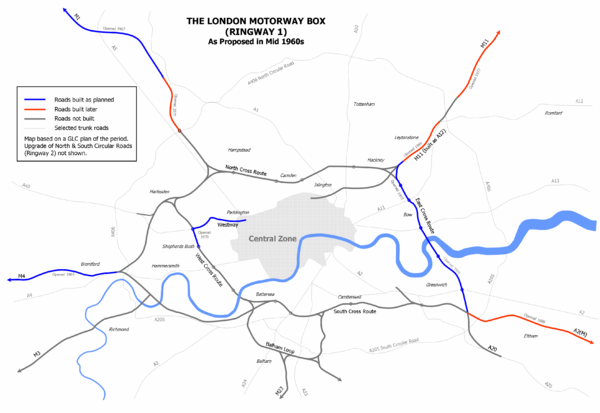
The Westway was built to form a link from Paddington to Ringway 1
, the innermost circuit of the London Ringways
network, part of a complex and comprehensive plan for a network of high speed roads circling and radiating out from central London designed to manage and control the flow of traffic within the capital. This plan had developed from early schemes prior to the Second World War through Patrick Abercrombie
's County of London Plan
, 1943 and Greater London Plan, 1944 to a 1960s Greater London Council
(GLC) scheme that would have involved the construction of many miles of motorway standard roads across the city and demolition on a massive scale.Due to the huge construction costs and widespread public opposition, most of the scheme was cancelled in 1973 and the Westway, the West Cross Route
and East Cross Route
in east London were the only significant parts to be built.
The construction of the elevated roundabout junction with the West Cross Route was built with the capability to be extended once the planned northern continuation of the West Cross Route was constructed to Harlesden
. Two stubs on the roundabout's north side were built for the connection of slip roads and the alignment of the slip roads between the West Cross Route and the roundabout avoid the planned line of the road to the north.
by J. G. Ballard
was set in a junction between the Westway and M4 Motorway
.
The Westway has featured in songs by many British Rock
bands:
The Westway is also featured on the front cover of A Weekend in the City
by Bloc Party
. The picture, part of A Modern Project was taken by German photographer Rut Blees Luxemburg
.
Dual carriageway
A dual carriageway is a class of highway with two carriageways for traffic travelling in opposite directions separated by a central reservation...
section of the A40
A40 road
The A40 is a major trunk road connecting London to Fishguard, Wales and officially called The London to Fishguard Trunk Road in all legal documents and Acts...
route in west London
London
London is the capital city of :England and the :United Kingdom, the largest metropolitan area in the United Kingdom, and the largest urban zone in the European Union by most measures. Located on the River Thames, London has been a major settlement for two millennia, its history going back to its...
running from Paddington
Paddington
Paddington is a district within the City of Westminster, in central London, England. Formerly a metropolitan borough, it was integrated with Westminster and Greater London in 1965...
to North Kensington
North Kensington
North Kensington is an area of west London lying north of Notting Hill Gate and south of Harrow Road.North Kensington is the key neighbourhood of Notting Hill...
. The road was constructed between 1964 and 1970 to relieve congestion at Shepherd's Bush
Shepherd's Bush
-Commerce:Commercial activity in Shepherd's Bush is now focused on the Westfield shopping centre next to Shepherd's Bush Central line station and on the many small shops which run along the northern side of the Green....
caused by traffic from Western Avenue struggling to enter central London on roads of insufficient capacity. The Westway opened in July 1970 as the A40(M) motorway but lost motorway status in 2000 when responsibility for trunk roads in Greater London
Greater London
Greater London is the top-level administrative division of England covering London. It was created in 1965 and spans the City of London, including Middle Temple and Inner Temple, and the 32 London boroughs. This territory is coterminate with the London Government Office Region and the London...
was transferred from the Highways Agency
Highways Agency
The Highways Agency is an executive agency, part of the Department for Transport in England. It has responsibility for managing the core road network in England...
to the Greater London Authority
Greater London Authority
The Greater London Authority is the top-tier administrative body for Greater London, England. It consists of a directly elected executive Mayor of London, currently Boris Johnson, and an elected 25-member London Assembly with scrutiny powers...
.
Route
At its eastern end, the Westway starts to the west of the Marylebone Flyover (A501), which takes traffic over the junction of Edgware Road (A5) and Marylebone RoadMarylebone Road
Marylebone Road is an important thoroughfare in central London, within the City of Westminster. It runs east-west from the Euston Road at Regent's Park to the A40 Westway at Paddington...
(A501). Between the elevated Westway and Flyover, a short (100 m) section of surface-level road allows westbound traffic from the Flyover to turn-off on to the Harrow Road
Harrow Road
The Harrow Road is an ancient route in Greater London which runs from Paddington in a northwesterly direction to Harrow. With minor deviations in the 19th and 20th centuries, the route remains otherwise unaltered...
(A404
A404 road
The A404 is a road in the United Kingdom that starts at Paddington in London and leads to Maidenhead in Berkshire.The road initially follows a course through London and its suburbs including Harlesden, Wembley, Harrow Pinner, and Rickmansworth...
) or eastbound traffic from the Harrow Road to access the Flyover. Eastbound traffic from the Westway cannot exit here to reach the Edgware Road and continues on to the Flyover.
Heading west, the Westway rises sharply as it passes Paddington Green (at this point having two lanes in each direction), then crosses the Grand Union Canal
Grand Union Canal
The Grand Union Canal in England is part of the British canal system. Its main line connects London and Birmingham, stretching for 137 miles with 166 locks...
branch to Paddington Basin
Paddington Basin
Paddington Basin is an area of Paddington, London named after the nearby canal basin.The junction of the Regent's Canal and the Grand Junction Canal is close to this point but the basin itself is the terminus of the Paddington Arm of the Grand Junction Canal. It was opened in 1801...
just south of Little Venice. As the road passes Westbourne Green on the north and Royal Oak Underground Station
Royal Oak tube station
Royal Oak tube station is a station of the London Underground, on the Hammersmith & City and Circle lines, between and stations. The station is on Lord Hills Bridge and is in Travelcard Zone 2 for the London Underground. Although not heavily used at other times, the station is extremely busy...
on the south, it gains a lane as a steeply climbing slip-road from Gloucester Terrace joins. In the eastbound direction, a lane is lost as a slip-road descends to cross the National Rail
National Rail
National Rail is a title used by the Association of Train Operating Companies as a generic term to define the passenger rail services operated in Great Britain...
tracks to Paddington station
Paddington station
Paddington railway station, also known as London Paddington, is a central London railway terminus and London Underground complex.The site is a historic one, having served as the London terminus of the Great Western Railway and its successors since 1838. Much of the current mainline station dates...
via the large plate-girder Westbourne Bridge, a road that previously carried traffic from Harrow Road to Bishops Bridge Road but was blocked at the north end and appropriated for the Westway scheme.
Continuing westward, the Westway runs parallel with the main-line railway for about 1/2 mi before turning south-west at Westbourne Park and crossing the railway to run immediately adjacent to London Underground
London Underground
The London Underground is a rapid transit system serving a large part of Greater London and some parts of Buckinghamshire, Hertfordshire and Essex in England...
's Hammersmith and City Line for 3/4 mi as far as Ladbroke Grove station
Ladbroke Grove tube station
Ladbroke Grove is a London Underground station on the Circle and Hammersmith & City lines, between Latimer Road and Westbourne Park stations, and in Travelcard Zone 2 set in The Royal Borough of Kensington and Chelsea ....
, after which it returns to a more east-west alignment for the 1/2 mi to the elevated roundabout junction with the West Cross Route
West Cross Route
The West Cross Route is a short, dual carriageway section of the A3220 route in central London in The Royal Borough of Kensington and Chelsea, with a small part being shared with borderlining borough Hammersmith and Fulham. It runs north-south between the northern elevated roundabout junction...
(A3220
A3220 road
The A3220 is a primary A road in London. It runs north from Clapham Common to the A40 Westway at Ladbroke Grove.The road crosses the River Thames at Battersea Bridge and from this point until its end it forms the western boundary of the London Congestion Charge zone...
) and flyover that takes vehicles high above the roundabout and Wood Lane
Wood Lane
Wood Lane is a street in London. It runs north from Shepherd's Bush, under the Westway past Wormwood Scrubs where it meets Scrubs Lane. The road is wholly in the London Borough of Hammersmith and Fulham...
(A219
A219 road
The A219, is a road in West London, England, which connects the A404 Harrow Road in Harlesden to the A24 in South Wimbledon. Running from North to South, it starts near Willesden Junction station, crosses the Grand Union Canal and runs through Shepherd's Bush, Hammersmith and Fulham, crossing the...
) to return to ground level and connect to the end of Western Avenue.
Since the extension westward of the London Congestion Charge Zone
London congestion charge
The London congestion charge is a fee charged for some categories of motor vehicle to travel at certain times within the Congestion Charge Zone , a traffic area in London. The charge aims to reduce congestion, and raise investment funds for London's transport system...
on 19 February 2007, the part of the road between Westbourne Park and the Westway roundabout that passes through the zone has been designated as a "free through route" that allows vehicles to cross the zone without paying the charge.
Construction
The route of the Westway was chosen to follow the easiest path from Western Avenue to Paddington by following the route of existing railway lines but passing an eight lane elevated motorway through densely populated VictorianVictorian era
The Victorian era of British history was the period of Queen Victoria's reign from 20 June 1837 until her death on 22 January 1901. It was a long period of peace, prosperity, refined sensibilities and national self-confidence...
North Kensington
North Kensington
North Kensington is an area of west London lying north of Notting Hill Gate and south of Harrow Road.North Kensington is the key neighbourhood of Notting Hill...
involved the clearance of a large number of buildings adjacent to the railway, particularly in the area west of Westbourne Park, where many roads were unceremoniously truncated or demolished to make way for the concrete structures.
At its opening the road was the largest continuous concrete structure in Britain and was constructed with many advanced features such as heating grids on slopes to control the formation of ice. It was planned and constructed in an era before environmental impacts were routinely considered, and it caused much controversy at the time for the effects it and the vehicles it carried had upon the local community and the environment.
Context
- See London RingwaysLondon RingwaysThe London Ringways were a series of four ring roads planned in the 1960s to circle London at various distances from the city centre. They were part of a comprehensive scheme developed by the Greater London Council to alleviate traffic congestion on the city's road system by providing high speed...
for a detailed history
The Westway was built to form a link from Paddington to Ringway 1
Ringway 1
Ringway 1 or the London Motorway Box was the innermost of the series of four motorway standard roads, known as the London Ringways as part of a comprehensive scheme developed by the Greater London Council to provide high speed motorway-standard roads within the capital linking a series of radial...
, the innermost circuit of the London Ringways
London Ringways
The London Ringways were a series of four ring roads planned in the 1960s to circle London at various distances from the city centre. They were part of a comprehensive scheme developed by the Greater London Council to alleviate traffic congestion on the city's road system by providing high speed...
network, part of a complex and comprehensive plan for a network of high speed roads circling and radiating out from central London designed to manage and control the flow of traffic within the capital. This plan had developed from early schemes prior to the Second World War through Patrick Abercrombie
Patrick Abercrombie
Sir Leslie Patrick Abercrombie ) was an English town planner. Educated at Uppingham School, Rutland; brother of Lascelles Abercrombie, poet and literary critic.-Career:...
's County of London Plan
County of London Plan
The County of London Plan was prepared for the London County Council in 1943. Its authors were John Henry Forshaw and Sir Leslie Patrick Abercrombie ....
, 1943 and Greater London Plan, 1944 to a 1960s Greater London Council
Greater London Council
The Greater London Council was the top-tier local government administrative body for Greater London from 1965 to 1986. It replaced the earlier London County Council which had covered a much smaller area...
(GLC) scheme that would have involved the construction of many miles of motorway standard roads across the city and demolition on a massive scale.Due to the huge construction costs and widespread public opposition, most of the scheme was cancelled in 1973 and the Westway, the West Cross Route
West Cross Route
The West Cross Route is a short, dual carriageway section of the A3220 route in central London in The Royal Borough of Kensington and Chelsea, with a small part being shared with borderlining borough Hammersmith and Fulham. It runs north-south between the northern elevated roundabout junction...
and East Cross Route
East Cross Route
East Cross Route is a dual-carriageway road constructed in east London as part of the uncompleted Ringway 1 as part of the London Ringways plan drawn up the 1960s to create a series of high speed roads circling and radiating out from central London...
in east London were the only significant parts to be built.
The construction of the elevated roundabout junction with the West Cross Route was built with the capability to be extended once the planned northern continuation of the West Cross Route was constructed to Harlesden
Harlesden
Harlesden is an area in the London Borough of Brent, northwest London, UK. Its main focal point is the Jubilee Clock which commemorates Queen Victoria's Golden Jubilee....
. Two stubs on the roundabout's north side were built for the connection of slip roads and the alignment of the slip roads between the West Cross Route and the roundabout avoid the planned line of the road to the north.
Popular culture
The 1974 novel Concrete IslandConcrete Island
Concrete Island is a 1974 English fiction novel by J. G. Ballard.- Plot introduction :A twisted adaptation of Robinson Crusoe, the story's protagonist, Robert Maitland, a wealthy architect, finds himself stranded in a manmade 'island' between the Westway and M4 Motorway in West London, forced to...
by J. G. Ballard
J. G. Ballard
James Graham Ballard was an English novelist, short story writer, and prominent member of the New Wave movement in science fiction...
was set in a junction between the Westway and M4 Motorway
M4 motorway
The M4 motorway links London with South Wales. It is part of the unsigned European route E30. Other major places directly accessible from M4 junctions are Reading, Swindon, Bristol, Newport, Cardiff and Swansea...
.
The Westway has featured in songs by many British Rock
British rock
British rock describes a wide variety of forms of music made in the United Kingdom. Since around 1964, with the "British Invasion" of the United States spearheaded by The Beatles, British rock music has had a considerable impact on the development of American music and rock music across the...
bands:
- The ClashThe ClashThe Clash were an English punk rock band that formed in 1976 as part of the original wave of British punk. Along with punk, their music incorporated elements of reggae, ska, dub, funk, rap, dance, and rockabilly...
gave the Westway a sarcastic mention in "London's BurningLondon's Burning (song)"London's Burning" is a song by The Clash from their eponymous debut album. It is the eighth track in the U.K. version of this album, and the seventh track in the U.S. version, from 1979....
": "I'm up and down the Westway, in and out the lights. What a great traffic system, it's so bright. I can't think of a better way to spend the night, than speeding around underneath the yellow lights." - In the BlurBlur (band)Blur is an English alternative rock band. Formed in London in 1989 as Seymour, the group consists of singer Damon Albarn, guitarist Graham Coxon, bassist Alex James and drummer Dave Rowntree. Blur's debut album Leisure incorporated the sounds of Madchester and shoegazing...
song "For TomorrowFor Tomorrow"For Tomorrow" is a song by English alternative rock band Blur. It is the lead track to their second album, Modern Life Is Rubbish . Released 19 April 1993 as the first single from the album, "For Tomorrow" charted at number 28 in the UK Singles Chart...
" part of the lyrics state that a couple have lost their way on the road. The full line is: "London's so nice back in your seamless rhymes, But we're lost on the Westway". - The Dirty Pretty ThingsDirty Pretty Things (band)Dirty Pretty Things were an English band fronted by Carl Barât, a member of The Libertines. The formation of the band was announced in September 2005, after a dispute between Barât and Pete Doherty led to the breakup of The Libertines in 2004. Barât had worked with Vertigo Records and had...
refer to the Westway in the song Truth Begins quoting "The Westway walls so tall and bleak/Reflect the words we dare not speak". It is also referenced in the Pete DohertyPete DohertyPeter Doherty is an English musician, writer, actor, poet and artist. He is best known musically for being co-frontman of The Libertines, which he reformed with Carl Barât in 2010. His other musical project is indie band Babyshambles...
song 'Broken Love Song' in the line 'By the Westway/Inside The ScrubsWormwood Scrubs (HM Prison)HM Prison Wormwood Scrubs is a Category B men's prison, located in the Wormwood Scrubs area of the London Borough of Hammersmith and Fulham, in inner west London, England. The prison is operated by Her Majesty's Prison Service....
' as he once claimed to have lived beside the Westway in a caravan.
The Westway is also featured on the front cover of A Weekend in the City
A Weekend In The City
A Weekend in the City is the second studio album by British indie rock band Bloc Party. It was recorded at Grouse Lodge Studios in Westmeath, Ireland, in mid-2006 and was produced by Jacknife Lee. The record was refined and mixed at several locations in London at the end of 2006...
by Bloc Party
Bloc Party
Bloc Party are a British Indie rock band, composed of Kele Okereke , Russell Lissack , Gordon Moakes , and Matt Tong...
. The picture, part of A Modern Project was taken by German photographer Rut Blees Luxemburg
Rut Blees Luxemburg
Rut Blees Luxemburg is a German photographer. Her technique is to take photographs at night, mostly exploring the urban landscape. She is a Tutor at the Royal College of Art.-Life and work:...
.
External links
- Westway.org - Notes on the history of Westway
- Motorway Archive - A40(M) Westway and M41 West Cross Route
- Pathetic Motorways - A40(M) Photographs