West Cross Route
Encyclopedia

Dual carriageway
A dual carriageway is a class of highway with two carriageways for traffic travelling in opposite directions separated by a central reservation...
section of the A3220
A3220 road
The A3220 is a primary A road in London. It runs north from Clapham Common to the A40 Westway at Ladbroke Grove.The road crosses the River Thames at Battersea Bridge and from this point until its end it forms the western boundary of the London Congestion Charge zone...
route in central London
London
London is the capital city of :England and the :United Kingdom, the largest metropolitan area in the United Kingdom, and the largest urban zone in the European Union by most measures. Located on the River Thames, London has been a major settlement for two millennia, its history going back to its...
in The Royal Borough of Kensington and Chelsea
Royal Borough of Kensington and Chelsea
The Royal Borough of Kensington and Chelsea is a central London borough of Royal borough status. After the City of Westminster, it is the wealthiest borough in England....
, with a small part being shared with borderlining borough Hammersmith and Fulham. It runs north-south between the northern elevated roundabout
Roundabout
A roundabout is the name for a road junction in which traffic moves in one direction around a central island. The word dates from the early 20th century. Roundabouts are common in many countries around the world...
junction with the western end of the Westway
Westway (London)
The Westway is a long elevated dual carriageway section of the A40 route in west London running from Paddington to North Kensington. The road was constructed between 1964 and 1970 to relieve congestion at Shepherd's Bush caused by traffic from Western Avenue struggling to enter central London on...
(A40) and the southern Holland Park
Holland Park
Holland Park is a district and a public park in the Royal Borough of Kensington and Chelsea, in west central London, England.Holland Park has a reputation as an affluent and fashionable area, known for attractive large Victorian townhouses, and high-class shopping and restaurants...
Roundabout
Roundabout
A roundabout is the name for a road junction in which traffic moves in one direction around a central island. The word dates from the early 20th century. Roundabouts are common in many countries around the world...
. It opened in 1970, together with the Westway.
The West Cross Route was formerly the M41 motorway. Its status was downgraded to an A-road
Great Britain road numbering scheme
The Great Britain road numbering scheme is a numbering scheme used to classify and identify all roads in Great Britain. Each road is given a single letter, which represents the road's category, and a subsequent number, with a length of between 1 and 4 digits. Originally introduced to arrange...
in 2000 when responsibility for trunk road
Trunk road
A trunk road, trunk highway, or strategic road is a major road—usually connecting two or more cities, ports, airports, and other things.—which is the recommended route for long-distance and freight traffic...
s in Greater London
Greater London
Greater London is the top-level administrative division of England covering London. It was created in 1965 and spans the City of London, including Middle Temple and Inner Temple, and the 32 London boroughs. This territory is coterminate with the London Government Office Region and the London...
was transferred from the Highways Agency
Highways Agency
The Highways Agency is an executive agency, part of the Department for Transport in England. It has responsibility for managing the core road network in England...
to the Greater London Authority
Greater London Authority
The Greater London Authority is the top-tier administrative body for Greater London, England. It consists of a directly elected executive Mayor of London, currently Boris Johnson, and an elected 25-member London Assembly with scrutiny powers...
.
Approximately half-way along the road's length a new junction was built to serve the Westfield London
Westfield London
Westfield London is a shopping centre in White City in the London Borough of Hammersmith and Fulham. The centre was developed by the Westfield Group at a cost of £1.6bn,...
shopping development.
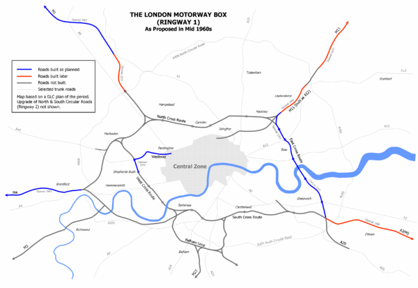
WCR was originally the designation for the western section of Ringway 1
Ringway 1
Ringway 1 or the London Motorway Box was the innermost of the series of four motorway standard roads, known as the London Ringways as part of a comprehensive scheme developed by the Greater London Council to provide high speed motorway-standard roads within the capital linking a series of radial...
, the innermost circuit of the London Ringways
London Ringways
The London Ringways were a series of four ring roads planned in the 1960s to circle London at various distances from the city centre. They were part of a comprehensive scheme developed by the Greater London Council to alleviate traffic congestion on the city's road system by providing high speed...
network, a complex and comprehensive plan for a network of high-speed roads circling central London
London
London is the capital city of :England and the :United Kingdom, the largest metropolitan area in the United Kingdom, and the largest urban zone in the European Union by most measures. Located on the River Thames, London has been a major settlement for two millennia, its history going back to its...
designed to manage and control the flow of traffic within the capital. The road would have run from Battersea
Battersea
Battersea is an area of the London Borough of Wandsworth, England. It is an inner-city district of South London, situated on the south side of the River Thames, 2.9 miles south-west of Charing Cross. Battersea spans from Fairfield in the west to Queenstown in the east...
to Harlesden
Harlesden
Harlesden is an area in the London Borough of Brent, northwest London, UK. Its main focal point is the Jubilee Clock which commemorates Queen Victoria's Golden Jubilee....
and would have paralleled the National Rail
National Rail
National Rail is a title used by the Association of Train Operating Companies as a generic term to define the passenger rail services operated in Great Britain...
West London Line
West London Line
The West London Line is a short railway in inner West London which links lines at in the south to lines near Willesden Junction in the north. It has always been an important cross-London link especially for freight services...
as an elevated road.
Although the road no longer has motorway status, pedal cycles are prohibited by a sign at Holland Park roundabout.
Reclaim the Streets street party
On July 13, 1996, the road was occupied by the direct action collective, Reclaim the StreetsReclaim the Streets
Reclaim The Streets is a collective with a shared ideal of community ownership of public spaces. Participants characterize the collective as a resistance movement opposed to the dominance of corporate forces in globalization, and to the car as the dominant mode of transport.-Protests:Reclaim The...
. After a cat-and-mouse game with the police, 6,000 protestors took over part of the elevated motorway, played sound-systems and danced. Sand was dumped on the motorway for young children to played on. Hidden underneath dancers walked on stilts and wore huge, wire-supported dresses, while environmental activists drilled holes in the tarmac and planted trees.
Context
- See London RingwaysLondon RingwaysThe London Ringways were a series of four ring roads planned in the 1960s to circle London at various distances from the city centre. They were part of a comprehensive scheme developed by the Greater London Council to alleviate traffic congestion on the city's road system by providing high speed...
for a detailed history
The WCR and the other roads planned in the 1960s for central London
Central London
Central London is the innermost part of London, England. There is no official or commonly accepted definition of its area, but its characteristics are understood to include a high density built environment, high land values, an elevated daytime population and a concentration of regionally,...
had developed from early schemes prior to the Second World War through Sir Patrick Abercrombie's
Patrick Abercrombie
Sir Leslie Patrick Abercrombie ) was an English town planner. Educated at Uppingham School, Rutland; brother of Lascelles Abercrombie, poet and literary critic.-Career:...
County of London Plan
County of London Plan
The County of London Plan was prepared for the London County Council in 1943. Its authors were John Henry Forshaw and Sir Leslie Patrick Abercrombie ....
, 1943 and Greater London Plan, 1944 to a 1960s Greater London Council
Greater London Council
The Greater London Council was the top-tier local government administrative body for Greater London from 1965 to 1986. It replaced the earlier London County Council which had covered a much smaller area...
(GLC) scheme that would have involved the construction of many miles of motorway-standard roads across the city and demolition on a massive scale. Due to the huge construction costs and widespread public opposition, most of the scheme was cancelled in 1973 and the WCR, Westway
Westway (London)
The Westway is a long elevated dual carriageway section of the A40 route in west London running from Paddington to North Kensington. The road was constructed between 1964 and 1970 to relieve congestion at Shepherd's Bush caused by traffic from Western Avenue struggling to enter central London on...
and the East Cross Route
East Cross Route
East Cross Route is a dual-carriageway road constructed in east London as part of the uncompleted Ringway 1 as part of the London Ringways plan drawn up the 1960s to create a series of high speed roads circling and radiating out from central London...
in east London were the only significant parts to be built.
At the northern end, had the road been built in full, the entry and exit ramps to and from the elevated roundabout with the Westway would have been slip roads. The main route would have continued north beneath the roundabout into North Kensington
North Kensington
North Kensington is an area of west London lying north of Notting Hill Gate and south of Harrow Road.North Kensington is the key neighbourhood of Notting Hill...
and on to the junction with the North Cross Route
North Cross Route
North Cross Route was a planned motorway-standard road which would have formed the northern section of Ringway 1 and would have formed the innermost circuit of the London Ringways network. The six-lane dual carriageway with grade separated junctions to an extended M1 Motorway was planned during...
at Harlesden
Harlesden
Harlesden is an area in the London Borough of Brent, northwest London, UK. Its main focal point is the Jubilee Clock which commemorates Queen Victoria's Golden Jubilee....
. The alignment of the slip roads leaves a wide space between for the unbuilt carriageway. On the north side of the roundabout, two short stubs indicate the starting point of the slip roads that would have been provided for traffic joining or leaving the northern section of the WCR.
South of the Holland Park roundabout, which the WCR would have passed above on a flyover, the route would have continued along the alignment of the West London Line passing over Kensington (Olympia) station
Kensington (Olympia) station
Kensington station is a station in West London managed and served by London Overground and also served by Southern and London Underground. It is in Travelcard Zone 2...
to a westbound-only interchange with the A4 at Talgarth Road. It would then have been elevated over Earls Court Exhibition Centre
Earls Court Exhibition Centre
The Earls Court Exhibition Centre is an exhibition centre, conference and event venue located in west London, United Kingdom in the Royal Borough of Kensington and Chelsea . It is the largest exhibition venue in central London. It is served by two underground stations, Earl's Court and West...
, skirted the western edge of Brompton Cemetery
Brompton Cemetery
Brompton Cemetery is located near Earl's Court in South West London, England . It is managed by The Royal Parks and is one of the Magnificent Seven...
, and passed by Stamford Bridge
Stamford Bridge (stadium)
Stamford Bridge is a football stadium in Fulham, in the London Borough of Hammersmith and Fulham, West London, and is the home of Chelsea Football Club. The stadium is located within the Moore Park Estate also known as Walham Green and is often referred to as simply The Bridge...
stadium before an eastbound-only interchange along Lots Road to meet Cheyne Walk
Cheyne Walk
Cheyne Walk , is a historic street in Chelsea, the Royal Borough of Kensington and Chelsea. It takes its name from William Lord Cheyne who owned the manor of Chelsea until 1712. Most of the houses were built in the early 18th century. Before the construction in the 19th century of the busy...
. Next the WCR would have crossed the River Thames
River Thames
The River Thames flows through southern England. It is the longest river entirely in England and the second longest in the United Kingdom. While it is best known because its lower reaches flow through central London, the river flows alongside several other towns and cities, including Oxford,...
on a new bridge and entered Battersea where it would have had a junction with the South Cross Route
South Cross Route
South Cross Route was the designation for the southern section of Ringway 1, the innermost circuit of the London Ringways network, a complex and comprehensive plan for a network of high speed roads circling and radiating out from central London designed to manage and control the flow of traffic...
.