
A201 road
Encyclopedia
The A201 is an A road in London
running from Kings Cross
to the Elephant and Castle
.
The route passes along Kings Cross Road, Farringdon Road, Farringdon Street, New Bridge Street, Blackfriars Bridge
, Blackfriars Road, London Road to the Elephant and Castle, and finally New Kent Road
where it merges with the A2 road
on the Old Kent Road
.
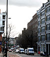
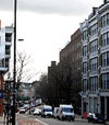
Farringdon Road is a road in Central London
.
It goes south-east from King's Cross Road, crossing Rosebery Avenue, then turns south crossing Clerkenwell
Road before going past Farringdon station
.
It finishes on the border between the City of London
, the London Borough of Camden
and the London Borough of Islington
, at an intersection with Charterhouse Street
and Farringdon Street.
, SE1
. It runs between St George's Circus
at the southern end and Blackfriars Bridge over the River Thames
at the northern end, leading to the City of London. Halfway up on the west side is Southwark tube station
, on the corner with The Cut
. Opposite is Palestra, the new building of the London Development Agency
, at No. 197.
The road adjoins Stamford Street
and Southwark Street
at the northern end.
London Road is a road in Southwark, London, which connects St George's Circus (north-west) and the Elephant and Castle roundabout (south-east). To the east is the campus of London South Bank University
including the Technopark
building and the London Road building, in a triangle formed by London Road, Borough Road
and Newington Causeway
. At the south-eastern end is the Elephant and Castle tube station.
The road is one-way for most traffic (flowing southeast), with a buses only lane heading in the opposite direction.
upgraded a local footpath. The road starts at Elephant and Castle, and runs eastward for a few hundred yards to a junction with Great Dover Street
and Tower Bridge Road (called the Bricklayer's Arms) before being renamed Old Kent Road (the A2
).
London
London is the capital city of :England and the :United Kingdom, the largest metropolitan area in the United Kingdom, and the largest urban zone in the European Union by most measures. Located on the River Thames, London has been a major settlement for two millennia, its history going back to its...
running from Kings Cross
Kings Cross, London
King's Cross is an area of London partly in the London Borough of Camden and partly in the London Borough of Islington. It is an inner-city district located 2.5 miles north of Charing Cross. The area formerly had a reputation for being a red light district and run-down. However, rapid regeneration...
to the Elephant and Castle
Elephant and Castle
The Elephant and Castle is a major road intersection in south London, England, located in the London Borough of Southwark. It is also used as a name for the surrounding area....
.
The route passes along Kings Cross Road, Farringdon Road, Farringdon Street, New Bridge Street, Blackfriars Bridge
Blackfriars Bridge
Blackfriars Bridge is a road and foot traffic bridge over the River Thames in London, between Waterloo Bridge and Blackfriars Railway Bridge, carrying the A201 road. The north end is near the Inns of Court and Temple Church, along with Blackfriars station...
, Blackfriars Road, London Road to the Elephant and Castle, and finally New Kent Road
New Kent Road
New Kent Road is a road in the London Borough of Southwark. The road was created in 1751 when the Turnpike Trust upgraded a local footpath. This was done as part of the general road improvements associated with the creation of Westminster Bridge; in effect it was possible to travel from the West...
where it merges with the A2 road
A2 road (Great Britain)
The A2 is a major road in southern England, connecting London with the English Channel port of Dover in Kent. This route has always been of importance as a connection between the British capital of London and sea trade routes to Continental Europe...
on the Old Kent Road
Old Kent Road
The Old Kent Road is a road in South East London, England and forms part of Watling Street, the Roman road which ran from Dover to Holyhead. The street is famous as the equal cheapest property on the London Monopoly board and as the only one in South London....
.
Kings Cross Road
Kings Cross Road runs south-east from Pentonville Road to the junction with Penton Rise where it turns directly south before running south-east again to Calthorpe Street where it meets Farringdon Road.Farringdon Road
Farringdon Road is a road in Central London
Central London
Central London is the innermost part of London, England. There is no official or commonly accepted definition of its area, but its characteristics are understood to include a high density built environment, high land values, an elevated daytime population and a concentration of regionally,...
.
It goes south-east from King's Cross Road, crossing Rosebery Avenue, then turns south crossing Clerkenwell
Clerkenwell
Clerkenwell is an area of central London in the London Borough of Islington. From 1900 to 1965 it was part of the Metropolitan Borough of Finsbury. The well after which it was named was rediscovered in 1924. The watchmaking and watch repairing trades were once of great importance...
Road before going past Farringdon station
Farringdon station
Farringdon station is a London Underground and National Rail station in Clerkenwell, just north of the City of London in the London Borough of Islington...
.
It finishes on the border between the City of London
City of London
The City of London is a small area within Greater London, England. It is the historic core of London around which the modern conurbation grew and has held city status since time immemorial. The City’s boundaries have remained almost unchanged since the Middle Ages, and it is now only a tiny part of...
, the London Borough of Camden
London Borough of Camden
In 1801, the civil parishes that form the modern borough were already developed and had a total population of 96,795. This continued to rise swiftly throughout the 19th century, as the district became built up; reaching 270,197 in the middle of the century...
and the London Borough of Islington
London Borough of Islington
The London Borough of Islington is a London borough in Inner London. It was formed in 1965 by merging the former metropolitan boroughs of Islington and Finsbury. The borough contains two Westminster parliamentary constituencies, Islington North and Islington South & Finsbury...
, at an intersection with Charterhouse Street
Charterhouse Street
Charterhouse Street is a street in Smithfield, on the northern boundary of the City of London, forming the boundary with both the London Borough of Camden and the London Borough of Islington...
and Farringdon Street.
Blackfriars Road
Blackfriars Road is a road in SouthwarkSouthwark
Southwark is a district of south London, England, and the administrative headquarters of the London Borough of Southwark. Situated east of Charing Cross, it forms one of the oldest parts of London and fronts the River Thames to the north...
, SE1
SE postcode area
The SE postcode area, also known as the London SE postcode area, is the part of the London post town covering part of south east London, England...
. It runs between St George's Circus
St George's Circus
St George's Circus is a road junction in Southwark, London, England. At its centre, which is now a traffic roundabout, is a historic obelisk, designed by Robert Mylne , in his role as surveyor and architect of Blackfriars Bridge.-History:...
at the southern end and Blackfriars Bridge over the River Thames
River Thames
The River Thames flows through southern England. It is the longest river entirely in England and the second longest in the United Kingdom. While it is best known because its lower reaches flow through central London, the river flows alongside several other towns and cities, including Oxford,...
at the northern end, leading to the City of London. Halfway up on the west side is Southwark tube station
Southwark tube station
Southwark tube station is a London Underground Jubilee line station in the London Borough of Southwark at the corner of Blackfriars Road and The Cut. It is between the and stations and is in Travelcard Zone 1. It was opened on 20 November 1999 as part of the Jubilee Line Extension...
, on the corner with The Cut
The Cut (London)
The Cut is a street in Lambeth and Southwark, London. It runs between Waterloo Road and Blackfriars Road . At the western end to the south is the well-established Old Vic Theatre and half way along on the north side is the more experimental Young Vic. Opposite the Young Vic is Short Street which...
. Opposite is Palestra, the new building of the London Development Agency
London Development Agency
The London Development Agency is the Regional Development Agency for Greater London, England. It is a functional body of the Greater London Authority...
, at No. 197.
The road adjoins Stamford Street
Stamford Street
Stamford Street is a street in Lambeth and Southwark, London England, just south of the River Thames. It runs between Waterloo Road to the west and Blackfriars Road to the east. At the western end, in the middle of a large roundabout, is the British Film Institute London IMAX Cinema...
and Southwark Street
Southwark Street
Southwark Street is a major street in the London Borough of Southwark, in London England, just south of the River Thames. It runs between Blackfriars Road to the west and Borough High Street to the east. It also connects the access routes for London Bridge, Southwark Bridge and Blackfriars Bridge...
at the northern end.
London Road
London Road is a road in Southwark, London, which connects St George's Circus (north-west) and the Elephant and Castle roundabout (south-east). To the east is the campus of London South Bank University
London South Bank University
London South Bank University is a university in south London. With over 25,000 students and 1,700 staff, it is based in the London Borough of Southwark, near the South Bank of the River Thames, from which it takes its name...
including the Technopark
South Bank Technopark
South Bank Technopark at London South Bank University, England, houses the main administration for the university, including the Vice-Chancellor's Office, under the leadership of Prof. Martin Earwicker....
building and the London Road building, in a triangle formed by London Road, Borough Road
Borough Road
Borough Road is in Southwark, London SE1. It runs east-west between St George's Circus and Borough High Street.- History and location :The route was created as part of the planning and road improvements associated with the completion of Westminster Bridge in 1750, to provide access to Southwark...
and Newington Causeway
Newington Causeway
Newington Causeway is a road in Southwark, London, England, between the Elephant and Castle and Borough High Street. The Elephant and Castle tube station is at the southern end....
. At the south-eastern end is the Elephant and Castle tube station.
The road is one-way for most traffic (flowing southeast), with a buses only lane heading in the opposite direction.
New Kent Road
New Kent Road was created in 1751 when the Turnpike TrustTurnpike trust
Turnpike trusts in the United Kingdom were bodies set up by individual Acts of Parliament, with powers to collect road tolls for maintaining the principal highways in Britain from the 17th but especially during the 18th and 19th centuries...
upgraded a local footpath. The road starts at Elephant and Castle, and runs eastward for a few hundred yards to a junction with Great Dover Street
Great Dover Street
Great Dover Street is in Southwark, south London, England. At the northwest end it joins Marshalsea Road and Borough High Street and there is a junction with Long Lane; Borough tube station is at this location. At the southeast end is the Bricklayers' Arms roundabout and flyover...
and Tower Bridge Road (called the Bricklayer's Arms) before being renamed Old Kent Road (the A2
A2 road (Great Britain)
The A2 is a major road in southern England, connecting London with the English Channel port of Dover in Kent. This route has always been of importance as a connection between the British capital of London and sea trade routes to Continental Europe...
).