
Grand Union Canal
Overview
Canal
Canals are man-made channels for water. There are two types of canal:#Waterways: navigable transportation canals used for carrying ships and boats shipping goods and conveying people, further subdivided into two kinds:...
in England is part of the British canal system
Canals of the United Kingdom
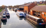
The canals of the United Kingdom are a major part of the network of inland waterways in the United Kingdom. They have a colourful history, from use for irrigation and transport, through becoming the focus of the Industrial Revolution, to today's role for recreational boating...
. Its main line connects London
London
London is the capital city of :England and the :United Kingdom, the largest metropolitan area in the United Kingdom, and the largest urban zone in the European Union by most measures. Located on the River Thames, London has been a major settlement for two millennia, its history going back to its...
and Birmingham
Birmingham
Birmingham is a city and metropolitan borough in the West Midlands of England. It is the most populous British city outside the capital London, with a population of 1,036,900 , and lies at the heart of the West Midlands conurbation, the second most populous urban area in the United Kingdom with a...
, stretching for 137 miles (220 km) with 166 locks. It has arms to places including Leicester
Leicester
Leicester is a city and unitary authority in the East Midlands of England, and the county town of Leicestershire. The city lies on the River Soar and at the edge of the National Forest...
, Slough
Slough
Slough is a borough and unitary authority within the ceremonial county of Royal Berkshire, England. The town straddles the A4 Bath Road and the Great Western Main Line, west of central London...
, Aylesbury
Aylesbury
Aylesbury is the county town of Buckinghamshire in South East England. However the town also falls into a geographical region known as the South Midlands an area that ecompasses the north of the South East, and the southern extremities of the East Midlands...
, Wendover
Wendover
Wendover is a market town that sits at the foot of the Chiltern Hills in Buckinghamshire, England. It is also a civil parish within Aylesbury Vale district...
and Northampton
Northampton
Northampton is a large market town and local government district in the East Midlands region of England. Situated about north-west of London and around south-east of Birmingham, Northampton lies on the River Nene and is the county town of Northamptonshire. The demonym of Northampton is...
.
The Grand Union Canal was also the original name for part of what is now part of the Leicester Line of the modern Grand Union: this latter is now generally referred to as the Old Grand Union Canal
Grand Union Canal (old)
The Grand Union Canal was a canal in England from Foxton, Leicestershire on the Leicester and Northampton canal to Buckby on the Grand Junction Canal...
in order to avoid ambiguity.
With competition from the railways having taken a large share of traffic in the second half of the 19th century, improvements in roads and vehicle technology in the early part of the 20th century meant that the lorry was also becoming a threat to the canals.