
2008 Atlanta tornado outbreak
Encyclopedia
The 2008 Atlanta tornado outbreak was a tornado outbreak
that affected the Southeastern United States
on March 14–15, 2008.
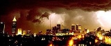
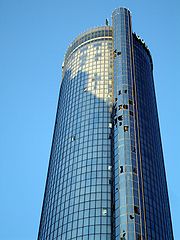
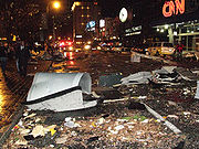
A tornado caused widespread damage across downtown Atlanta
, including to the CNN Center
and to the Georgia Dome
, where the 2008 SEC Men's Basketball Tournament
was postponed. Other buildings that were damaged include the Georgia World Congress Center
, Philips Arena
(during an Atlanta Hawks
game), and the Omni Hotel, which was evacuated after many windows were blown out. The Westin Peachtree Plaza
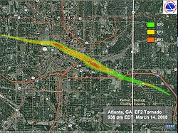
suffered major window damage; Centennial Olympic Park
, the SunTrust Tower and historic Oakland Cemetery were also damaged. One man was killed near downtown Atlanta and 30 others were injured. Two other deaths took place on March 15 in the northern Atlanta suburbs from the second, larger round of severe weather and tornadoes. In total, 45 tornadoes were confirmed over the 24 hour period from eastern Alabama
to the Carolina
coast, with most of the activity concentrated in the Metropolitan Atlanta area, the Central Savannah River Area
and the Midlands
of South Carolina
.
 In their 9:00 pm EDT outlook, the Storm Prediction Center
issued a slight risk of severe weather across portions of the southern United States
from Oklahoma
to Georgia
, with a 2% risk area for tornadoes for the Atlanta area. A tornado warning
was issued for Atlanta at 9:26 pm when the thunderstorm
that caused the tornado was 6 miles (10 km) to the northwest of the downtown area, although no watches were in effect for the area due to the low probability and unusual isolated nature. The tornado drifted southward as it moved eastward, whereas most tornadic storms have a strong northward component along (or ahead of) a cold front
. It also was unusual because it was not associated with such a squall line
at all, but was an independent supercell
drifting well ahead of the main storm system.
 CNN Center
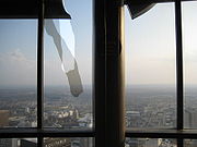
was severely damaged, including shattered window
s. The Georgia World Congress Center
also sustained serious damage, as was the Omni Hotel, especially the skywalk between the two hotel towers over Andrew Young International Boulevard. This complex alone lost 476 windows, making it necessary to close the south tower to guests. The facade
s of the Georgia Dome
and a Philips Arena
parking garage were damaged while hosting basketball
games.
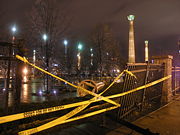
Two of the giant columns in Centennial Olympic Park
were knocked down, and bits of insulation
were stuck in tree
s. Trees on some other streets, where more closely built skyscraper
s cause a greater wind tunnel
effect, were knocked completely down, despite being too early in spring
to involve leaf drag
. Glass
was strewn across several street
s, and Atlanta Police kept residents, hotel
guests, and news crews away from buildings with loose glass, which continued to pose a danger into the night. Cars in the area also had windows blown out, and hotel and office furniture
was found scattered about.
 The Ritz Carlton, Westin Peachtree Plaza
, Georgia-Pacific Building, SunTrust Tower (where more than 60 people had to be relocated out of their offices), Equitable Building
, and Georgia State University
also had windows blown out (300 at Equitable alone), as did The Tabernacle
(a former church with stained glass
that is now a concert venue). The windows of the Westin continued to fall for days after the tornado, forcing police to keep several city blocks and MARTA
's Peachtree Center
station closed to pedestrians. The Georgia World Congress Center
also sustained flooding while hosting a JROTC event and the Hinman Dental Meeting; Fox Sports Net
took footage
of a staircase in the new section of the complex that looked like a fountain
with water
cascading down it. The annual Atlanta Home Show and all other events were cancelled for the weekend in the GWCC complex, as was the Atlanta St. Patrick's Day Parade scheduled for the next day. WRAS
FM at Georgia State University
was off the air for two days, though it was not stated whether its studio or tower sustained damage, or if this were due to security or safety concerns, or power outages. The historic Rialto Theatre at GSU also sustained roof damage, which in turn caused water damage inside.
Further east, Grady Hospital reported some damage to windows and a brief power outage
. Many of the injured were taken there, and some walked there and were treated in the emergency room for cuts due to glass. The King Memorial
MARTA
station was damaged and was being bypassed by trains, with buses rerouted to the next station on each side. Oakland Cemetery suffered major damage to monument
s and to its huge oaks
and magnolias, and the caretaker
found window blind
s around the neck of a statue
of a Civil War
veteran buried there.
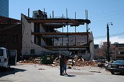
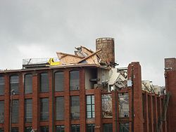
 In the nearby Cabbagetown
area, a brick
loft
building (well-known for the fire that occurred there in 1999, during its renovation from the Fulton Bag and Cotton Mills
, in which the crane
operator was rescue
d by helicopter
during live TV news coverage) lost part of its roof, and part of the top (fifth) floor. Another building at The Stacks on Boulevard partially collapsed; search and rescue
personnel were unable to enter, but everyone was accounted for by the management within a few hours.
When the tornado hit, a SEC
tournament
game between Mississippi State
and Alabama
which had just been sent into overtime minutes earlier by a shot from Mykal Riley, was in progress at the Georgia Dome. The storm ripped panels from the exterior of the building and tore at least two holes in the roof of the Dome, causing insulation to fall and the scoreboard
and catwalks suspended from the roof to sway. Mykal Riley's shot was considered to have saved lives by keeping people safe inside the Georgia Dome. After a 64-minute delay, the game was completed, however the next scheduled game between Kentucky
and Georgia
was postponed. The remainder of the tournament games were played at Alexander Memorial Coliseum
on the campus of Georgia Tech
, with spectators restricted to team and conference personnel, media, team bands, and families of players only due to the much smaller size of the alternate venue. At the nearby Philips Arena, little disruption was noticed by the attendees during the game between the Hawks and the Los Angeles Clippers
, even though damage occurred to the outside of the arena.
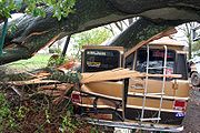
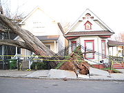
Twenty-seven people were treated for injuries. In addition, over 20 homes were completely destroyed.
 All of CNN
's TV networks remained on the air, but there was damage to the glass roof of the CNN Center
atrium, flooding part of the food court. Additionally, blown-out windows in the ground floor CNN.com newsroom and the fourth floor videotape library caused minor damage. Live news
coverage of the aftermath was carried on CNN International
, in turn simulcast
domestically on CNN until 1 am EDT. CNN resumed broadcasting from their main newsroom at 6 am EDT, showing several parts of the newsroom with computer stations covered with tarps
, the damaged atrium
of CNN Center, and staff using trash cans and buckets to collect dripping rainwater to the right of the anchor desk due to the damaged roof. When more storms moved in later in the day, the network was forced to move all Atlanta on-camera operations to the windowless CNN-I studio, while taped programming was shown for most of the day.
The city received emergency assistance from the Georgia Emergency Management Agency
(GEMA), Highway Emergency Response Operators (HEROs), Fulton
and DeKalb
counties (where Atlanta is situated), and surrounding cities and counties. Atlanta Mayor Shirley Franklin
also declared a state of emergency
for the city and Governor Sonny Perdue
issued a state state of emergency
declaration for Atlanta enabling the city to seek disaster aid from the Federal Emergency Management Agency
(FEMA). President Bush declared a major disaster on March 20.
 In raw U.S. dollars, it was the most expensive tornado in American history after the 1999 Oklahoma City tornado, costing a half-billion dollars. When adjusted for inflation
, it ranks ninth.
Tornado outbreak
While there is no single agreed upon definition, generally at least 6-10 tornadoes produced by the same synoptic scale weather system is considered a tornado outbreak. The tornadoes usually occur within the same day, or continue into the early morning hours of the succeeding day, and within the...
that affected the Southeastern United States
Southeastern United States
The Southeastern United States, colloquially referred to as the Southeast, is the eastern portion of the Southern United States. It is one of the most populous regions in the United States of America....
on March 14–15, 2008.
A tornado caused widespread damage across downtown Atlanta
Downtown Atlanta
Downtown Atlanta is the first and largest of the three financial districts in the city of Atlanta. Downtown Atlanta is the location of many corporate or regional headquarters, city, county, state and federal government facilities, sporting facilities, and is the central tourist attraction of the city...
, including to the CNN Center
CNN Center
The CNN Center is the world headquarters of the Cable News Network . The main newsrooms and studios for several of CNN's news channels are located in the building...
and to the Georgia Dome
Georgia Dome
The Georgia Dome is a domed stadium located in Atlanta, Georgia, United States, between downtown to the east and Vine City to the west. It is primarily the home stadium for the NFL Atlanta Falcons and the NCAA Division I FCS Georgia State Panthers football team. It is owned and operated by the...
, where the 2008 SEC Men's Basketball Tournament
2008 SEC Men's Basketball Tournament
The 2008 SEC Men's Basketball Tournament took place on March 13–16, 2008 in Atlanta, Georgia. The first, quarterfinal, and semifinal rounds were televised by Raycom/LF Sports, and the SEC Championship Game was produced by CBS and televised by ESPN2...
was postponed. Other buildings that were damaged include the Georgia World Congress Center
Georgia World Congress Center
The Georgia World Congress Center or GWCC is the major convention center in Atlanta. It is the fourth-largest convention center in the United States at 3.9 million ft2 and hosts more than a million visitors each year. At the time opened in 1976 the Georgia World Congress Center was the first state...
, Philips Arena
Philips Arena
Philips Arena is an indoor arena in Atlanta, Georgia.Completed in 1999 to replace The Omni, at a cost of $213.5 million, it is home to the Atlanta Hawks, of the National Basketball Association, and the Atlanta Dream, of the Women's National Basketball Association...
(during an Atlanta Hawks
Atlanta Hawks
The Atlanta Hawks are an American professional basketball team based in Atlanta, Georgia. They are part of the Southeast Division of the Eastern Conference in the National Basketball Association .-The first years:...
game), and the Omni Hotel, which was evacuated after many windows were blown out. The Westin Peachtree Plaza
Westin Peachtree Plaza
The Westin Peachtree Plaza, Atlanta is a skyscraper hotel in downtown Atlanta, Georgia, on Peachtree Street adjacent to the Peachtree Center complex and the former Davison's/Macy's flagship store...
suffered major window damage; Centennial Olympic Park
Centennial Olympic Park
Centennial Olympic Park is a 21 acre public park located in downtown Atlanta, Georgia, USA that is owned and operated by the Georgia World Congress Center Authority. The park was built by the Atlanta Committee for the Olympic Games as part of the infrastructure improvements for the Centennial...
, the SunTrust Tower and historic Oakland Cemetery were also damaged. One man was killed near downtown Atlanta and 30 others were injured. Two other deaths took place on March 15 in the northern Atlanta suburbs from the second, larger round of severe weather and tornadoes. In total, 45 tornadoes were confirmed over the 24 hour period from eastern Alabama
Alabama
Alabama is a state located in the southeastern region of the United States. It is bordered by Tennessee to the north, Georgia to the east, Florida and the Gulf of Mexico to the south, and Mississippi to the west. Alabama ranks 30th in total land area and ranks second in the size of its inland...
to the Carolina
The Carolinas
The Carolinas is a term used in the United States to refer collectively to the states of North and South Carolina. Together, the two states + have a population of 13,942,126. "Carolina" would be the fifth most populous state behind California, Texas, New York, and Florida...
coast, with most of the activity concentrated in the Metropolitan Atlanta area, the Central Savannah River Area
Central Savannah River Area
The Central Savannah River Area is a 13-county region in the U.S. state of Georgia, and is also considered to include five to eight counties in South Carolina. The term was coined in 1950 by C.C. McCollum, the winner of a $250 contest held by The Augusta Chronicle to generate the best name for the...
and the Midlands
Midlands, South Carolina
The Midlands roughly refers to an area in the middle of South Carolina. Columbia is the largest city in the region and location of the state government...
of South Carolina
South Carolina
South Carolina is a state in the Deep South of the United States that borders Georgia to the south, North Carolina to the north, and the Atlantic Ocean to the east. Originally part of the Province of Carolina, the Province of South Carolina was one of the 13 colonies that declared independence...
.
Atlanta tornado event
Storm Prediction Center
The Storm Prediction Center , located in Norman, Oklahoma, is tasked with forecasting the risk of severe thunderstorms and tornadoes in the contiguous United States. The agency issues convective outlooks, mesoscale discussions, and watches as a part of this process...
issued a slight risk of severe weather across portions of the southern United States
Southern United States
The Southern United States—commonly referred to as the American South, Dixie, or simply the South—constitutes a large distinctive area in the southeastern and south-central United States...
from Oklahoma
Oklahoma
Oklahoma is a state located in the South Central region of the United States of America. With an estimated 3,751,351 residents as of the 2010 census and a land area of 68,667 square miles , Oklahoma is the 28th most populous and 20th-largest state...
to Georgia
Georgia (U.S. state)
Georgia is a state located in the southeastern United States. It was established in 1732, the last of the original Thirteen Colonies. The state is named after King George II of Great Britain. Georgia was the fourth state to ratify the United States Constitution, on January 2, 1788...
, with a 2% risk area for tornadoes for the Atlanta area. A tornado warning
Tornado warning
A tornado warning is an alert issued by government weather services to warn that severe thunderstorms with tornadoes may be imminent. It can be issued after a tornado or funnel cloud has been spotted by eye, or more commonly if there are radar indications of tornado formation...
was issued for Atlanta at 9:26 pm when the thunderstorm
Thunderstorm
A thunderstorm, also known as an electrical storm, a lightning storm, thundershower or simply a storm is a form of weather characterized by the presence of lightning and its acoustic effect on the Earth's atmosphere known as thunder. The meteorologically assigned cloud type associated with the...
that caused the tornado was 6 miles (10 km) to the northwest of the downtown area, although no watches were in effect for the area due to the low probability and unusual isolated nature. The tornado drifted southward as it moved eastward, whereas most tornadic storms have a strong northward component along (or ahead of) a cold front
Cold front
A cold front is defined as the leading edge of a cooler mass of air, replacing a warmer mass of air.-Development of cold front:The cooler and denser air wedges under the less-dense warmer air, lifting it...
. It also was unusual because it was not associated with such a squall line
Squall line
A squall line is a line of severe thunderstorms that can form along or ahead of a cold front. In the early 20th century, the term was used as a synonym for cold front. It contains heavy precipitation, hail, frequent lightning, strong straight-line winds, and possibly tornadoes and waterspouts....
at all, but was an independent supercell
Supercell
A supercell is a thunderstorm that is characterized by the presence of a mesocyclone: a deep, continuously-rotating updraft. For this reason, these storms are sometimes referred to as rotating thunderstorms...
drifting well ahead of the main storm system.
March 15 tornado event
Another tornado outbreak struck the southeast the following day. A moderate risk for severe storms was issued early in the morning, and maintained through the afternoon. However, by mid afternoon, areas of east-central Georgia and central South Carolina were upgraded to a high risk of severe storms due to the tornado threat.Confirmed tornadoes
March 14 event
| List of reported tornadoes - Friday, March 14, 2008 | ||||||
|---|---|---|---|---|---|---|
Enhanced Fujita Scale The Enhanced Fujita Scale rates the strength of tornadoes in the United States based on the damage they cause.Implemented in place of the Fujita scale introduced in 1971 by Ted Fujita, it began operational use on February 1, 2007. The scale has the same basic design as the original Fujita scale:... |
|
|
|
|
|
|
| Georgia Georgia (U.S. state) Georgia is a state located in the southeastern United States. It was established in 1732, the last of the original Thirteen Colonies. The state is named after King George II of Great Britain. Georgia was the fourth state to ratify the United States Constitution, on January 2, 1788... |
||||||
| EF2 | Atlanta Atlanta, Georgia Atlanta is the capital and most populous city in the U.S. state of Georgia. According to the 2010 census, Atlanta's population is 420,003. Atlanta is the cultural and economic center of the Atlanta metropolitan area, which is home to 5,268,860 people and is the ninth largest metropolitan area in... |
Fulton Fulton County, Georgia Fulton County is a county located in the U.S. state of Georgia. Its county seat is Atlanta, the state capital since 1868 and the principal county of the Atlanta metropolitan area... , DeKalb DeKalb County, Georgia DeKalb County is a county located in the U.S. state of Georgia. The population of the county was 691,893 at the 2010 census. Its county seat is the city of Decatur. It is bordered to the west by Fulton County and contains roughly 10% of the city of Atlanta... |
33.87°N 84.43°W | 0140 | 6 miles (9.7 km) | 1 death - See section on this tornado |
| Sources: Storm reports of March 14, 2008 |
||||||
March 15 event
| List of reported tornadoes - Saturday, March 15, 2008 | ||||||
|---|---|---|---|---|---|---|
Enhanced Fujita Scale The Enhanced Fujita Scale rates the strength of tornadoes in the United States based on the damage they cause.Implemented in place of the Fujita scale introduced in 1971 by Ted Fujita, it began operational use on February 1, 2007. The scale has the same basic design as the original Fujita scale:... |
|
|
|
|
|
|
| Alabama Alabama Alabama is a state located in the southeastern region of the United States. It is bordered by Tennessee to the north, Georgia to the east, Florida and the Gulf of Mexico to the south, and Mississippi to the west. Alabama ranks 30th in total land area and ranks second in the size of its inland... |
||||||
| EF2 | SE of Oneonta Oneonta, Alabama Oneonta is a city in Blount County, Alabama, United States. At the 2000 census the population was 5,576. The city is the county seat of Blount County... |
Blount Blount County, Alabama Blount County is a county located in the U.S. state of Alabama. As of the 2010 United States Census, the population was 57,322. Its county seat is Oneonta.Blount County is a dry county.-History:... |
33.89°N 86.42°W | 1450 | 6 miles (9.7 km) | 25 houses sustained major damage and many others had minor damage. One mobile home and many farm buildings and outbuildings were destroyed, killing many animals. |
| EF2 | NE of Pleasant Gap | Cherokee Cherokee County, Alabama Cherokee County, Alabama is a county of the U.S. state of Alabama. It is named for the Cherokee tribe. As of 2010 the population was 25,989. Its county seat is Centre and it is a prohibition or dry county.- History :... |
34.02°N 85.48°W | 1600 | 3 miles (4.8 km) | Major damage to a roof of a house and a barn, as well as snapped pine trees. |
| Georgia Georgia (U.S. state) Georgia is a state located in the southeastern United States. It was established in 1732, the last of the original Thirteen Colonies. The state is named after King George II of Great Britain. Georgia was the fourth state to ratify the United States Constitution, on January 2, 1788... |
||||||
| EF3 | Aragon Aragon, Georgia Aragon is a city in Polk County, Georgia, United States. The population was 1,039 at the 2000 census.-Geography:Aragon is located at .According to the United States Census Bureau, the city has a total area of , all of it land.... area |
Polk Polk County, Georgia Polk County is a county located in the U.S. state of Georgia. As of 2000, the population was 38,127. The 2007 Census Estimate shows a population of 41,460. The county seat is Cedartown.- History :... , Floyd Floyd County, Georgia Floyd County is a county located in the U.S. state of Georgia. As of 2000, the population was 90,565. Census estimates for 2007 show a population of 95,618... , Bartow Bartow County, Georgia Bartow County is a county located in the U.S. state of Georgia. As of the 2010 census, the population was 100,157. According to the U.S. Census Bureau's July 1, 2009 estimate, the county's explosive growth resulted in a population of 96,217, a 26.5% increase in less than ten years... |
34.10°N 85.12°W | 1625 | 16 miles (26 km) | 2 deaths - Large wedge tornado destroyed at least 20 houses and damaged hundreds of others. Thousands of trees were knocked down across three counties. Two others were injured. |
| EF0 | Franklin Springs Franklin Springs, Georgia Franklin Springs is a city in Franklin County, Georgia, United States. The population was 762 at the 2000 census. Emmanuel College is located here.-Geography:Franklin Springs is located at .... area |
Franklin Franklin County, Georgia Franklin County is a county located in the U.S. state of Georgia. It became Georgia's ninth county, incorporating on February 25, 1784, and was named in honor of patriot Benjamin Franklin... , Hart Hart County, Georgia Hart County is a county located in the U.S. state of Georgia. It was created December 7, 1853. As of 2000, the population was 22,997. The 2007 Census Estimate shows a population of 24,240. The county seat is Hartwell.... |
34.28°N 83.15°W | 1844 | 3 miles (4.8 km) | Tornado confirmed with widespread damage to trees and power lines. Major damage to a couple of houses and cattle barns. |
| EF1 | NE of Gill | Lincoln Lincoln County, Georgia Lincoln County is a county located in the U.S. state of Georgia, with the Savannah River forming its northeastern border. Located above the fall line, it is part of the Central Savannah River Area and a member of the CSRA Regional Development Center. The county was created on February 20, 1796. ... , McCormick (SC) |
33.57°N 82.35°W | 2015 | 16 miles (26 km) | Many trees were knocked down. |
| EF2 | SE of Fortsonia | Elbert Elbert County, Georgia Elbert County is a county located in the U.S. state of Georgia. It was established on December 10, 1790 and was named for Samuel Elbert. As of 2000, the population was 20,511. The 2007 Census Estimate shows a population of 20,525... |
33.99°N 82.75°W | 2019 | 7.3 miles (11.7 km) | Damage reported to several structures, including a roof blown off a house and a boat dock thrown in the air in Bobby Brown State Park Bobby Brown State Park Bobby Brown State Outdoor Recreation Area is a 665 acre Georgia state park located near Chennault and Middleton. The park's name is a memorial to Robert T. Brown, a lieutenant in the U.S. Navy who was killed during World War II... . |
| EF1 | N of Winfield | McDuffie McDuffie County, Georgia McDuffie County is a county located in the U.S. state of Georgia. It was created on October 18, 1870. As of 2000, the population was 21,231. The 2007 Census Estimate showed a population of 21,551. The county seat is Thomson.... , Columbia Columbia County, Georgia Columbia County is a county located in the US state of Georgia along the Savannah River. As of 2010 the population was 124,054 a growth of 39% from the 2000 census figure of 89,288. The de jure county seat is Appling. Appling is an unincorporated area, making Columbia one of only three counties... |
33.36°N 82.24°W | 2148 | 8 miles (13 km) | One mobile home was destroyed and several others damaged. Many trees were knocked down. Two people were injured. |
| EF0 | W of Jackson Jackson, Georgia Jackson is a city in Butts County, Georgia, United States. The population was 3,934 at the 2000 census. The city is the county seat of Butts County. The center of population of Georgia is located in Jackson. The community was named after President Andrew Jackson. Founded in 1826, Jackson began as... |
Butts Butts County, Georgia Butts County is a county located in the northern half of the U.S. state of Georgia. It was created on December 24, 1825. As of 2000, the population was 19,522. The 2007 Census Estimate showed a population of 23,759... |
33.29°N 84.08°W | 2215 | 3.25 miles (5 km) | A barn was destroyed and numerous trees were knocked down. |
| EF2 | Matthews area | Jefferson Jefferson County, Georgia Jefferson County is a county located in the U.S. state of Georgia. It was created on February 20, 1796. As of 2000, the population was 17,266. The 2007 Census Estimate shows a population of 16,454... , Burke Burke County, Georgia Burke County is a county located in the U.S. state of Georgia. As of 2000, the population was 22,243. The 2007 Census Estimate showed a population of 22,754... |
33.21°N 82.31°W | 2215 | 19 miles (31 km) | Several mobile homes were destroyed and numerous houses were damaged, some by fallen trees. |
| EF1 | SE of Waynesboro Waynesboro, Georgia Waynesboro is a city in Burke County, Georgia, United States. The population was 5,813 at the 2000 census. The city is the county seat of Burke County... |
Burke Burke County, Georgia Burke County is a county located in the U.S. state of Georgia. As of 2000, the population was 22,243. The 2007 Census Estimate showed a population of 22,754... |
33.13°N 81.89°W | 2305 | 15 miles (24 km) | One house sustained moderate damage to the roof, windows and shingles. Several mobile homes were damaged. |
| EF2 | NE of Springfield Springfield, Georgia Springfield is a city in Effingham County, Georgia, United States. The population was 2,520 at the 2010 census. The city is the county seat of Effingham County .Springfield is part of the Savannah Metropolitan Statistical Area.-History:... |
Effingham Effingham County, Georgia Effingham County is a county located in the U.S. state of Georgia. In the United States Census of 2000, the population was 37,535. The Census Bureau's 2008 estimate estimates that this figure has grown to 52,060. The seat of Effingham County is Springfield.... |
32.47°N 81.22°W | 0134 | 2.5 miles (4 km) | Over 40 houses were damaged, and three mobile homes and many outbuildings, barns and sheds were destroyed. Power transmission towers were also knocked down. Six people were injured, both in vehicles and mobile homes. |
| EF2 | NE of Rincon Rincon, Georgia Rincon is a city in Effingham County, Georgia, United States. The population was 4,376 at the 2000 census. It is part of the Savannah Metropolitan Statistical Area.-History:... |
Effingham Effingham County, Georgia Effingham County is a county located in the U.S. state of Georgia. In the United States Census of 2000, the population was 37,535. The Census Bureau's 2008 estimate estimates that this figure has grown to 52,060. The seat of Effingham County is Springfield.... |
32.30°N 81.24°W | 0144 | 0.5 miles (804.7 m) | Tornado impacted the McIntosh Plant of Georgia Power Georgia Power Georgia Power is an electric utility headquartered in Atlanta, Georgia, United States. It is the largest of the four electric utilities that are owned and operated by Southern Company.... , where several buildings were destroyed. |
| South Carolina South Carolina South Carolina is a state in the Deep South of the United States that borders Georgia to the south, North Carolina to the north, and the Atlantic Ocean to the east. Originally part of the Province of Carolina, the Province of South Carolina was one of the 13 colonies that declared independence... |
||||||
| EF0 | Due West Due West, South Carolina Due West is a town in Abbeville County, South Carolina, United States. The population was 1,209 at the 2000 census.-Geography:Due West is located at .... |
Abbeville Abbeville County, South Carolina Abbeville County is a county located in the U.S. state of South Carolina. In 2010, its population was 25,147. Its county seat is Abbeville. It is the first county in the United States alphabetically.-History:... |
34.33°N 82.39°W | 1950 | 1 miles (1.6 km) | Tornado reported by a local sheriff Sheriff A sheriff is in principle a legal official with responsibility for a county. In practice, the specific combination of legal, political, and ceremonial duties of a sheriff varies greatly from country to country.... with trees damaged. |
| EF0 | N of Bucklick | Fairfield, Kershaw | 34.27°N 80.49°W | 2010 | 25 miles (40 km) | Long track tornado with tree damage. |
| EF3 | Prosperity Prosperity, South Carolina Prosperity is a town in Newberry County, South Carolina, United States. The population was 1,047 at the 2000 census.-Geography:Prosperity is located at .... area |
Newberry, Richland Richland County, South Carolina Richland County is a county located in the U.S. state of South Carolina. The 2000 U.S. census recorded its population to be 320,677. In 2010, the U.S. Census Bureau recorded that its population had reached 384,504. It is the second most populous county in South Carolina, behind only Greenville... |
34.25°N 81.53°W | 2025 | 28 miles (45 km) | Many houses sustained major damage and mobile homes were destroyed. Two people were injured. |
| EF1 | Lugoff Lugoff, South Carolina Lugoff is a small census-designated place in Kershaw County, South Carolina, United States. The population was 6,278 at the 2000 census. The population was nearly 85% rural in 2000... area (1st tornado) |
Kershaw | 34.23°N 80.63°W | 2030 | 23 miles (37 km) | Numerous houses and mobile homes damaged and trees down. |
| EF0 | SE of Angelus | Chesterfield Chesterfield County, South Carolina -Demographics:As of the census of 2000, there were 42,768 people, 16,557 households, and 11,705 families residing in the county. The population density was 54 people per square mile . There were 18,818 housing units at an average density of 24 per square mile... |
34.33°N 80.01°W | 2047 | 7 miles (11 km) | Long track tornado with tree damage. |
| EF1 | McCormick McCormick, South Carolina McCormick is a town in McCormick County, South Carolina, United States. The population was 1,489 at the 2000 census. It is the county seat of McCormick County.-Geography:McCormick is located at .... area |
McCormick, Edgefield | 33.91°N 82.40°W | 2102 | 24 miles (39 km) | Long track tornado with intermittent light to moderate damage, affecting numerous houses and mobile homes. |
| EF2 | Elgin Elgin, South Carolina Elgin is the name of some places in the U.S. state of South Carolina:*Elgin, Kershaw County, South Carolina*Elgin, Lancaster County, South Carolina... area |
Kershaw | 34.10°N 80.45°W | 2122 | 7 miles (11 km) | Large wedge tornado tore through town damaging many houses and destroying four mobile homes. Two people were injured. |
| EF1 | SW of Ward Ward, South Carolina Ward is a town in Saluda County, South Carolina, United States. The population was 110 at the 2000 census. It is part of the Columbia, South Carolina Metropolitan Statistical Area.-Geography:Ward is located at .... |
Saluda | 33.51°N 81.47°W | 2124 | 3 miles (4.8 km) | Major damage to one house and many trees knocked down. |
| EF0 | Lugoff Lugoff, South Carolina Lugoff is a small census-designated place in Kershaw County, South Carolina, United States. The population was 6,278 at the 2000 census. The population was nearly 85% rural in 2000... area (2nd tornado) |
Kershaw | 34.13°N 80.40°W | 2133 | 1 miles (1.6 km) | Brief tornado touchdown. |
| EF0 | SE of Monetta Monetta, South Carolina Monetta is a town in Aiken and Saluda counties in the U.S. state of South Carolina. The population was 220 at the 2000 census.The Saluda County portion of Monetta is part of the Columbia, South Carolina Metropolitan Statistical Area, while the Aiken County portion is part of the Augusta, Georgia... |
Aiken Aiken County, South Carolina Aiken County is a county located in the U.S. state of South Carolina. In 2000, its population was 142,552; in 2010, the U.S. Census Bureau estimated that its population had reached 160,099... |
33.49°N 81.34°W | 2137 | 1 miles (1.6 km) | Brief tornado touchdown knocked down trees. |
| EF1 | Pelion Pelion, South Carolina Pelion is a town in Lexington County, South Carolina, United States. The population was 553 at the 2000 census. It is part of the Columbia, South Carolina Metropolitan Statistical Area... area |
Lexington | 33.48°N 81.20°W | 2141 | 8 miles (13 km) | One mobile home was heavily damaged and farm equipment was damaged. |
| EF1 | E of Sharp | Richland Richland County, South Carolina Richland County is a county located in the U.S. state of South Carolina. The 2000 U.S. census recorded its population to be 320,677. In 2010, the U.S. Census Bureau recorded that its population had reached 384,504. It is the second most populous county in South Carolina, behind only Greenville... |
34.10°N 80.53°W | 2143 | 4 miles (6.4 km) | Significant damage in the Lake Carolina area with homes damaged and trees knocked down, especially near Columbia Country Club. |
| EF0 | Latta Latta, South Carolina Latta is a town in Dillon County, South Carolina, United States. The population was 1,410 at the 2000 census. This small town also contains one of the many libraries that were started with funds given by Andrew Carnegie, which is located in the center of town.... |
Dillon | 34.34°N 79.43°W | 2148 | 1.2 miles (1.9 km) | Minor damage to seven houses, some of which was caused by fallen trees. |
| EF1 | N of Wolfton | Orangeburg, Calhoun Calhoun County, South Carolina Calhoun County is a county located in the U.S. state of South Carolina. In 2000, its population was 15,185; a 2005 Census Bureau estimate placed the population at 15,100. It is named for John C. Calhoun, the former U.S. Vice-President, Senator, Representative and cabinet member from South... |
33.38°N 81.01°W | 2205 | 21 miles (34 km) | Several houses and barns were damaged and outbuildings were destroyed. Tree damage reported in the area. |
| EF0 | N of Pleasant Lane | Edgefield | 33.25°N 81.29°W | 2211 | 4 miles (6.4 km) | Trees down in a heavily forested area. |
| EF2 | Clearwater Clearwater, South Carolina Clearwater is a census-designated place in Aiken County, South Carolina, United States. It lies near North Augusta, South Carolina, and is part of the Augusta, Georgia metropolitan area. Clearwater is located in historic Horse Creek Valley... area |
Aiken Aiken County, South Carolina Aiken County is a county located in the U.S. state of South Carolina. In 2000, its population was 142,552; in 2010, the U.S. Census Bureau estimated that its population had reached 160,099... |
33.25°N 81.29°W | 2218 | 25 miles (40 km) | Large wedge tornado up to 1 mile (1.6 km) wide destroyed a water tower and heavily damaged many houses. |
| EF1 | S of Florence Florence, South Carolina -Municipal government and politics:The City of Florence has a council-manager form of government. The mayor and city council are elected every four years, with no term limits... |
Florence Florence County, South Carolina Florence is a county located in the U.S. state of South Carolina. In 2000, its population was recorded to be 125,761; in 2005, the U.S. Census Bureau estimated that its population had reached 131,097. Its county seat is Florence. The county's population is about 60% urban and it comprises part of... |
34.12°N 79.78°W | 2225 | 14 miles (23 km) | Over 80 houses were damaged and about 10 trailers were rolled. At least 16 were also impacted. Three people suffered minor injuries and two livestock Livestock Livestock refers to one or more domesticated animals raised in an agricultural setting to produce commodities such as food, fiber and labor. The term "livestock" as used in this article does not include poultry or farmed fish; however the inclusion of these, especially poultry, within the meaning... were killed. |
| EF0 | W of Williston Williston, South Carolina Williston is a town in Barnwell County, South Carolina, United States. The population was 3,307 at the 2000 census.The town lies in the center of the Charleston-Hamburg railroad line, the line of the Best Friend locomotive. The train tracks were removed in the 1990s, however, the track site has... |
Barnwell Barnwell County, South Carolina -History:The Barnwell District was created in 1798 from the southwestern portion of the Orangeburg District, along the Savannah River... |
33.25°N 81.28°W | 2247 | unknown | Brief tornado touchdown with no damage. |
| EF1 | S of Ashwood | Lee | 34.06°N 80.15°W | 2252 | 14 miles (23 km) | Several houses, mobile homes and a church were damaged. |
| EF0 | E of Elko Elko, South Carolina Elko is a town in Barnwell County, South Carolina. The population was 212 at the 2000 census.-Geography:Elko is located at .According to the United States Census Bureau, the town has a total area of , all of it land.-Demographics:... |
Barnwell Barnwell County, South Carolina -History:The Barnwell District was created in 1798 from the southwestern portion of the Orangeburg District, along the Savannah River... |
33.22°N 81.21°W | 2254 | unknown | Brief tornado touchdown with no damage. |
| EF0 | S of Manning Manning, South Carolina Manning is a city in South Carolina and the county seat of Clarendon County in the Southeastern United States, located in the center of the county, just to the east of Interstate 95 and at the intersection of U.S. 301 and U.S. 521. The population was estimated to be 3,943 as of 2008, down 2% from... |
Clarendon | 33.32°N 80.06°W | 2302 | 8 miles (13 km) | Tornado tracked along the north shore of Lake Marion Lake Marion (South Carolina) Lake Marion is the largest lake in South Carolina, centrally located and with territory within five counties. The lake is referred to as South Carolina's inland sea. It has a shoreline and covers nearly 110,000 acres of rolling farmlands, former marshes, and river valley landscape... . Minor damage to several houses. |
| EF1 | SE of Denmark Denmark, South Carolina Denmark is a city in Bamberg County, South Carolina, United States. The population was 2,934 at the 2009 census.-Geography:Denmark is located at .According to the... |
Bamberg Bamberg County, South Carolina -Demographics:As of the census of 2000, there were 16,658 people, 6,123 households, and 4,255 families residing in the county. The population density was 42 people per square mile . There were 7,130 housing units at an average density of 18 per square mile... |
34.06°N 80.15°W | 2305 | 2 miles (3.2 km) | Several houses sustained moderate damage, and power poles were knocked down. |
| EF0 | Aynor Aynor, South Carolina Aynor is a town in Horry County, South Carolina, United States. The population was 647 in September 2011. The surrounding Aynor area of Galivants Ferry has a population of 5,429 as of September 2011.-Geography:Aynor is located at .... |
Horry Horry County, South Carolina Horry County is a county located in the U.S. state of South Carolina. This name honored Revolutionary War Hero, Peter Horry. Brigadier General Horry was born in South Carolina sometime around 1743 and started his distinguished military career in 1775 as one of 20 captains the Provincial Congress... |
33.92°N 79.16°W | 2313 | 0.25 miles (402.3 m) | A mobile home and a car port were destroyed, which also damaged trees and power lines. |
| EF1 | S of Greeleyville Greeleyville, South Carolina Greeleyville is a town in Williamsburg County, South Carolina, United States. The population was 375 at the 2009 census.-Geography:Greeleyville is located at .... |
Williamsburg | 33.56°N 79.99°W | 2317 | 1.5 miles (2.4 km) | One house was damaged and a church steeple Steeple (architecture) A steeple, in architecture, is a tall tower on a building, often topped by a spire. Steeples are very common on Christian churches and cathedrals and the use of the term generally connotes a religious structure... was toppled. Extensive tree damage. |
| EF3 | Branchville Branchville, South Carolina Branchville is a town in Orangeburg County, South Carolina, United States. The population was 1,083 at the 2000 census.When the train depot was in use, three presidents stopped by the depot: William H... area |
Bamberg Bamberg County, South Carolina -Demographics:As of the census of 2000, there were 16,658 people, 6,123 households, and 4,255 families residing in the county. The population density was 42 people per square mile . There were 7,130 housing units at an average density of 18 per square mile... , Orangeburg |
33.25°N 80.82°W | 2325 | 14 miles (23 km) | Widespread damage in the area from a large wedge tornado with 17 houses damaged or destroyed. Many downtown buildings and a fire station were also damaged or destroyed in Branchville. |
| EF1 | Trio | Williamsburg | 33.48°N 79.72°W | 2336 | 3 miles (4.8 km) | A total of 35 houses were damaged, of which one was destroyed. |
| EF1 | SW of Oakland Oakland, South Carolina Oakland is a census-designated place in Sumter County, South Carolina, United States. The population was 1,272 at the 2000 census. It is included in the Sumter, South Carolina Metropolitan Statistical Area... |
Georgetown | 33.28°N 79.22°W | 2354 | 20 yards (18.3 m) | Very brief tornado blew a few trees onto a house. |
| EF1 | N of Ridgeville Ridgeville, South Carolina Ridgeville is a town in Dorchester County, South Carolina, United States. The population was 1,690 at the 2000 census. As defined by the U.S. Office of Management and Budget, and used by the U.S... |
Dorchester | 33.10°N 80.32°W | 0008 | 2.2 miles (3.5 km) | Rope tornado with metal panels removed from a gas station canopy. Two mobile homes were also heavily damaged. |
| EF1 | Strawberry | Berkeley Berkeley County, South Carolina Berkeley County is a county in the U.S. state of South Carolina. In 2000, its population was 142,651. The 2005 Census Bureau estimate placed the population at 151,673. Its county seat is Moncks Corner.... |
33.09°N 80.03°W | 0025 | 0.6 miles (965.6 m) | Heavy damage to a mobile home park with 14 mobile homes impacted. Seven people were injured. |
| EF1 | N of Charity | Berkeley Berkeley County, South Carolina Berkeley County is a county in the U.S. state of South Carolina. In 2000, its population was 142,651. The 2005 Census Bureau estimate placed the population at 151,673. Its county seat is Moncks Corner.... |
33.05°N 79.85°W | 0036 | 1.2 miles (1.9 km) | Roofs were damaged on a church and a house. Many trees were knocked down. |
| North Carolina North Carolina North Carolina is a state located in the southeastern United States. The state borders South Carolina and Georgia to the south, Tennessee to the west and Virginia to the north. North Carolina contains 100 counties. Its capital is Raleigh, and its largest city is Charlotte... |
||||||
| EF0 | Fair Bluff Fair Bluff, North Carolina Fair Bluff is a town in Columbus County, North Carolina, United States. The population was 1,181 at the 2000 census.-Geography:Fair Bluff is located at , along the banks of the Lumber River... |
Columbus Columbus County, North Carolina -Demographics:As of the census of 2000, there were 54,749 people, 21,308 households, and 15,043 families residing in the county. The population density was 58/sq mi . As of 2004, there were 24,668 housing units at an average density of 26/sq mi... |
34.31°N 79.03°W | 2210 | 30 yards (27 m) | Very short-lived tornado damaging a few trees amidst straight-line wind damage. |
| EF1 | Hampstead Hampstead, North Carolina Hampstead is an unincorporated community in Pender County, North Carolina, United States. It is located between Wilmington and Jacksonville on U.S. Route 17... |
Pender Pender County, North Carolina -Demographics:As of the census of 2000, there were 41,082 people, 16,054 households, and 11,719 families residing in the county. The population density was 47 people per square mile . There were 20,798 housing units at an average density of 24 per square mile... |
34.37°N 77.70°W | 2356 | 2 miles (3.2 km) | Several houses and businesses were damaged in the area. |
| Sources: Storm reports of March 15, 2008, NWS Birmingham, NWS Wilmington, NWS Peachtree City, NWS Greenville, NWS Columbia, NWS Charleston |
||||||
Atlanta tornado
CNN Center
The CNN Center is the world headquarters of the Cable News Network . The main newsrooms and studios for several of CNN's news channels are located in the building...
was severely damaged, including shattered window
Window
A window is a transparent or translucent opening in a wall or door that allows the passage of light and, if not closed or sealed, air and sound. Windows are usually glazed or covered in some other transparent or translucent material like float glass. Windows are held in place by frames, which...
s. The Georgia World Congress Center
Georgia World Congress Center
The Georgia World Congress Center or GWCC is the major convention center in Atlanta. It is the fourth-largest convention center in the United States at 3.9 million ft2 and hosts more than a million visitors each year. At the time opened in 1976 the Georgia World Congress Center was the first state...
also sustained serious damage, as was the Omni Hotel, especially the skywalk between the two hotel towers over Andrew Young International Boulevard. This complex alone lost 476 windows, making it necessary to close the south tower to guests. The facade
Facade
A facade or façade is generally one exterior side of a building, usually, but not always, the front. The word comes from the French language, literally meaning "frontage" or "face"....
s of the Georgia Dome
Georgia Dome
The Georgia Dome is a domed stadium located in Atlanta, Georgia, United States, between downtown to the east and Vine City to the west. It is primarily the home stadium for the NFL Atlanta Falcons and the NCAA Division I FCS Georgia State Panthers football team. It is owned and operated by the...
and a Philips Arena
Philips Arena
Philips Arena is an indoor arena in Atlanta, Georgia.Completed in 1999 to replace The Omni, at a cost of $213.5 million, it is home to the Atlanta Hawks, of the National Basketball Association, and the Atlanta Dream, of the Women's National Basketball Association...
parking garage were damaged while hosting basketball
Basketball
Basketball is a team sport in which two teams of five players try to score points by throwing or "shooting" a ball through the top of a basketball hoop while following a set of rules...
games.
Two of the giant columns in Centennial Olympic Park
Centennial Olympic Park
Centennial Olympic Park is a 21 acre public park located in downtown Atlanta, Georgia, USA that is owned and operated by the Georgia World Congress Center Authority. The park was built by the Atlanta Committee for the Olympic Games as part of the infrastructure improvements for the Centennial...
were knocked down, and bits of insulation
Building insulation
building insulation refers broadly to any object in a building used as insulation for any purpose. While the majority of insulation in buildings is for thermal purposes, the term also applies to acoustic insulation, fire insulation, and impact insulation...
were stuck in tree
Tree
A tree is a perennial woody plant. It is most often defined as a woody plant that has many secondary branches supported clear of the ground on a single main stem or trunk with clear apical dominance. A minimum height specification at maturity is cited by some authors, varying from 3 m to...
s. Trees on some other streets, where more closely built skyscraper
Skyscraper
A skyscraper is a tall, continuously habitable building of many stories, often designed for office and commercial use. There is no official definition or height above which a building may be classified as a skyscraper...
s cause a greater wind tunnel
Wind tunnel
A wind tunnel is a research tool used in aerodynamic research to study the effects of air moving past solid objects.-Theory of operation:Wind tunnels were first proposed as a means of studying vehicles in free flight...
effect, were knocked completely down, despite being too early in spring
Spring (season)
Spring is one of the four temperate seasons, the transition period between winter and summer. Spring and "springtime" refer to the season, and broadly to ideas of rebirth, renewal and regrowth. The specific definition of the exact timing of "spring" varies according to local climate, cultures and...
to involve leaf drag
Drag (physics)
In fluid dynamics, drag refers to forces which act on a solid object in the direction of the relative fluid flow velocity...
. Glass
Glass
Glass is an amorphous solid material. Glasses are typically brittle and optically transparent.The most familiar type of glass, used for centuries in windows and drinking vessels, is soda-lime glass, composed of about 75% silica plus Na2O, CaO, and several minor additives...
was strewn across several street
Street
A street is a paved public thoroughfare in a built environment. It is a public parcel of land adjoining buildings in an urban context, on which people may freely assemble, interact, and move about. A street can be as simple as a level patch of dirt, but is more often paved with a hard, durable...
s, and Atlanta Police kept residents, hotel
Hotel
A hotel is an establishment that provides paid lodging on a short-term basis. The provision of basic accommodation, in times past, consisting only of a room with a bed, a cupboard, a small table and a washstand has largely been replaced by rooms with modern facilities, including en-suite bathrooms...
guests, and news crews away from buildings with loose glass, which continued to pose a danger into the night. Cars in the area also had windows blown out, and hotel and office furniture
Furniture
Furniture is the mass noun for the movable objects intended to support various human activities such as seating and sleeping in beds, to hold objects at a convenient height for work using horizontal surfaces above the ground, or to store things...
was found scattered about.
Westin Peachtree Plaza
The Westin Peachtree Plaza, Atlanta is a skyscraper hotel in downtown Atlanta, Georgia, on Peachtree Street adjacent to the Peachtree Center complex and the former Davison's/Macy's flagship store...
, Georgia-Pacific Building, SunTrust Tower (where more than 60 people had to be relocated out of their offices), Equitable Building
Equitable Building (Atlanta)
The Equitable Building is a 35-story, 453 foot tall office building in Atlanta, Georgia, located at 100 Peachtree Street in the Fairlie-Poplar neighborhood in downtown Atlanta...
, and Georgia State University
Georgia State University
Georgia State University is a research university in downtown Atlanta, Georgia, USA. Founded in 1913, it serves about 30,000 students and is one of the University System of Georgia's four research universities...
also had windows blown out (300 at Equitable alone), as did The Tabernacle
The Tabernacle
The Tabernacle, informally known as The Tabby, is a mid-size concert hall, in the U.S. city of Atlanta, currently managed by concert promoter Live Nation...
(a former church with stained glass
Stained glass
The term stained glass can refer to coloured glass as a material or to works produced from it. Throughout its thousand-year history, the term has been applied almost exclusively to the windows of churches and other significant buildings...
that is now a concert venue). The windows of the Westin continued to fall for days after the tornado, forcing police to keep several city blocks and MARTA
Metropolitan Atlanta Rapid Transit Authority
The Metropolitan Atlanta Rapid Transit Authority or MARTA is the principal rapid-transit system in the Atlanta metropolitan area and the ninth-largest in the United States. Formed in 1971 as strictly a bus system, MARTA operates a network of bus routes linked to a rapid transit system consisting...
's Peachtree Center
Peachtree Center (MARTA station)
Peachtree Center station is an underground Train station on the Red and Gold lines of the Metropolitan Atlanta Rapid Transit Authority rail system. It is the deepest station in the MARTA rail system, at below Peachtree Street. It serves the Peachtree Center area of downtown Atlanta, and is the...
station closed to pedestrians. The Georgia World Congress Center
Georgia World Congress Center
The Georgia World Congress Center or GWCC is the major convention center in Atlanta. It is the fourth-largest convention center in the United States at 3.9 million ft2 and hosts more than a million visitors each year. At the time opened in 1976 the Georgia World Congress Center was the first state...
also sustained flooding while hosting a JROTC event and the Hinman Dental Meeting; Fox Sports Net
Fox Sports Net
The Fox Sports Regional Networks, or simply Fox Sports Net , are a collection of cable TV regional sports networks in the United States owned and operated by News Corporation.- Beginnings :...
took footage
Footage
In filmmaking and video production, footage is the raw, unedited material as it had been originally filmed by movie camera or recorded by a video camera which usually must be edited to create a motion picture, video clip, television show or similar completed work...
of a staircase in the new section of the complex that looked like a fountain
Fountain
A fountain is a piece of architecture which pours water into a basin or jets it into the air either to supply drinking water or for decorative or dramatic effect....
with water
Water
Water is a chemical substance with the chemical formula H2O. A water molecule contains one oxygen and two hydrogen atoms connected by covalent bonds. Water is a liquid at ambient conditions, but it often co-exists on Earth with its solid state, ice, and gaseous state . Water also exists in a...
cascading down it. The annual Atlanta Home Show and all other events were cancelled for the weekend in the GWCC complex, as was the Atlanta St. Patrick's Day Parade scheduled for the next day. WRAS
WRAS (FM)
WRAS is a college radio station in Atlanta with a frequency of 88.5MHz, which has been in operation since January 18th 1971. It is owned by Georgia State University and its on-air staff are all GSU students, with the exception of those who broadcast the University's athletic events for the station...
FM at Georgia State University
Georgia State University
Georgia State University is a research university in downtown Atlanta, Georgia, USA. Founded in 1913, it serves about 30,000 students and is one of the University System of Georgia's four research universities...
was off the air for two days, though it was not stated whether its studio or tower sustained damage, or if this were due to security or safety concerns, or power outages. The historic Rialto Theatre at GSU also sustained roof damage, which in turn caused water damage inside.
Further east, Grady Hospital reported some damage to windows and a brief power outage
Power outage
A power outage is a short- or long-term loss of the electric power to an area.There are many causes of power failures in an electricity network...
. Many of the injured were taken there, and some walked there and were treated in the emergency room for cuts due to glass. The King Memorial
King Memorial (MARTA station)
King Memorial is an elevated station on the Blue and part-time on the Green lines of the Metropolitan Atlanta Rapid Transit Authority rail system located in the Old Fourth Ward, near Oakland Cemetery. The station name is a portmanteau of Martin Luther King and nearby Memorial Drive. It provides...
MARTA
Marta
Marta may refer to:* Marta or Marta Vieira da Silva , a Brazilian women's football forward* Marta Estrella, a recurring fictional character from Arrested Development...
station was damaged and was being bypassed by trains, with buses rerouted to the next station on each side. Oakland Cemetery suffered major damage to monument
Monument
A monument is a type of structure either explicitly created to commemorate a person or important event or which has become important to a social group as a part of their remembrance of historic times or cultural heritage, or simply as an example of historic architecture...
s and to its huge oaks
Oaks
-Horse races:"Oaks" is generally used to describe a Thoroughbred horse race restricted to 3-year-old fillies. Among the best-known races using the term are:*Epsom Oaks, The Oaks Stakes, at Epsom Downs Racecourse, Surrey, England; the original "Oaks" race...
and magnolias, and the caretaker
Sexton
Sexton may refer to:*Sexton , a self-propelled artillery vehicle of World War II*Sexton , a church or synagogue officer charged with the maintenance of the church buildings and/or the surrounding graveyard; and ringing of the church bells...
found window blind
Window blind
A window blind is a type of window coverings. There are many different kinds of window blinds, using different systems and materials. A typical window blind is made with slats of fabric, wood, plastic or metal that adjust by rotating from an open position to a closed position by allowing slats to...
s around the neck of a statue
Statue
A statue is a sculpture in the round representing a person or persons, an animal, an idea or an event, normally full-length, as opposed to a bust, and at least close to life-size, or larger...
of a Civil War
American Civil War
The American Civil War was a civil war fought in the United States of America. In response to the election of Abraham Lincoln as President of the United States, 11 southern slave states declared their secession from the United States and formed the Confederate States of America ; the other 25...
veteran buried there.
Cabbagetown (Atlanta)
Cabbagetown is a neighborhood in Atlanta, Georgia located south of Inman Park, east of Oakland Cemetery, north of Grant Park and west of Reynoldstown. It includes Cabbagetown District, a historic district listed on the U.S...
area, a brick
Brick
A brick is a block of ceramic material used in masonry construction, usually laid using various kinds of mortar. It has been regarded as one of the longest lasting and strongest building materials used throughout history.-History:...
loft
Loft
A loft can be an upper story or attic in a building, directly under the roof. Alternatively, a loft apartment refers to large adaptable open space, often converted for residential use from some other use, often light industrial...
building (well-known for the fire that occurred there in 1999, during its renovation from the Fulton Bag and Cotton Mills
Fulton Bag and Cotton Mills
Fulton Bag and Cotton Mills is a formerly-operating mill complex located in the Cabbagetown neighborhood of Atlanta, Georgia. Construction of the complex began in 1881 on the south side of the Georgia Railroad line, east of downtown Atlanta, on the site of the Atlanta Rolling Mill...
, in which the crane
Crane (machine)
A crane is a type of machine, generally equipped with a hoist, wire ropes or chains, and sheaves, that can be used both to lift and lower materials and to move them horizontally. It uses one or more simple machines to create mechanical advantage and thus move loads beyond the normal capability of...
operator was rescue
Rescue
Rescue refers to responsive operations that usually involve the saving of life, or prevention of injury during an incident or dangerous situation....
d by helicopter
Helicopter
A helicopter is a type of rotorcraft in which lift and thrust are supplied by one or more engine-driven rotors. This allows the helicopter to take off and land vertically, to hover, and to fly forwards, backwards, and laterally...
during live TV news coverage) lost part of its roof, and part of the top (fifth) floor. Another building at The Stacks on Boulevard partially collapsed; search and rescue
Search and rescue
Search and rescue is the search for and provision of aid to people who are in distress or imminent danger.The general field of search and rescue includes many specialty sub-fields, mostly based upon terrain considerations...
personnel were unable to enter, but everyone was accounted for by the management within a few hours.
When the tornado hit, a SEC
Southeastern Conference
The Southeastern Conference is an American college athletic conference that operates in the southeastern part of the United States. It is headquartered in Birmingham, Alabama...
tournament
2008 SEC Men's Basketball Tournament
The 2008 SEC Men's Basketball Tournament took place on March 13–16, 2008 in Atlanta, Georgia. The first, quarterfinal, and semifinal rounds were televised by Raycom/LF Sports, and the SEC Championship Game was produced by CBS and televised by ESPN2...
game between Mississippi State
Mississippi State Bulldogs
The Mississippi State Bulldogs are the athletic teams of Mississippi State University. They participate in NCAA's Division I in the competitive 12-member Southeastern Conference under the mascot Bulldogs and the school colors of maroon and white...
and Alabama
Alabama Crimson Tide men's basketball
The Alabama Crimson Tide men's basketball program has a history of being among the best of the Southeastern Conference . It trails only Kentucky in basketball wins, SEC tournament titles, and SEC regular season titles in the 12-member conference. The team is coached by head coach Anthony Grant,...
which had just been sent into overtime minutes earlier by a shot from Mykal Riley, was in progress at the Georgia Dome. The storm ripped panels from the exterior of the building and tore at least two holes in the roof of the Dome, causing insulation to fall and the scoreboard
Scoreboard
A scoreboard is a large board for publicly displaying the score in a game or match. Most levels of sport from high school and above use at least one scoreboard for keeping score, measuring time, and displaying statistics. Scoreboards in the past used a mechanical clock and numeral cards to...
and catwalks suspended from the roof to sway. Mykal Riley's shot was considered to have saved lives by keeping people safe inside the Georgia Dome. After a 64-minute delay, the game was completed, however the next scheduled game between Kentucky
Kentucky Wildcats men's basketball
The Kentucky Wildcats men's basketball team, representing the University of Kentucky, is the winningest in the history of college basketball, both in all-time wins and all-time winning percentage. Kentucky's all-time record currently stands at 2058–647...
and Georgia
Georgia Bulldogs
The Georgia Bulldogs are the athletic teams of the University of Georgia. The Bulldogs compete in National Collegiate Athletic Association Division I and are members of the Southeastern Conference...
was postponed. The remainder of the tournament games were played at Alexander Memorial Coliseum
Alexander Memorial Coliseum
The Alexander Memorial Coliseum is an indoor arena located in Atlanta, Georgia, United States. It is the home of the basketball teams of Georgia Tech and hosted the Atlanta Hawks of the NBA from 1968–1972 and again from 1997–1999...
on the campus of Georgia Tech
Georgia Institute of Technology
The Georgia Institute of Technology is a public research university in Atlanta, Georgia, in the United States...
, with spectators restricted to team and conference personnel, media, team bands, and families of players only due to the much smaller size of the alternate venue. At the nearby Philips Arena, little disruption was noticed by the attendees during the game between the Hawks and the Los Angeles Clippers
Los Angeles Clippers
The Los Angeles Clippers are a professional basketball team based in Los Angeles, California, United States. They play in the Pacific Division of the Western Conference of the National Basketball Association...
, even though damage occurred to the outside of the arena.
Twenty-seven people were treated for injuries. In addition, over 20 homes were completely destroyed.
CNN
Cable News Network is a U.S. cable news channel founded in 1980 by Ted Turner. Upon its launch, CNN was the first channel to provide 24-hour television news coverage, and the first all-news television channel in the United States...
's TV networks remained on the air, but there was damage to the glass roof of the CNN Center
CNN Center
The CNN Center is the world headquarters of the Cable News Network . The main newsrooms and studios for several of CNN's news channels are located in the building...
atrium, flooding part of the food court. Additionally, blown-out windows in the ground floor CNN.com newsroom and the fourth floor videotape library caused minor damage. Live news
News
News is the communication of selected information on current events which is presented by print, broadcast, Internet, or word of mouth to a third party or mass audience.- Etymology :...
coverage of the aftermath was carried on CNN International
CNN International
CNN International is an international English language television network that carries news, current affairs, politics, opinions, and business programming worldwide. CNN is one of the world's largest news organizations. It is owned by Time Warner, and is affiliated with CNN, which is mainly...
, in turn simulcast
Simulcast
Simulcast, shorthand for "simultaneous broadcast", refers to programs or events broadcast across more than one medium, or more than one service on the same medium, at the same time. For example, Absolute Radio is simulcast on both AM and on satellite radio, and the BBC's Prom concerts are often...
domestically on CNN until 1 am EDT. CNN resumed broadcasting from their main newsroom at 6 am EDT, showing several parts of the newsroom with computer stations covered with tarps
Tarpaulin
A tarpaulin, colloquially tarp, is a large sheet of strong, flexible, water-resistant or waterproof material, often cloth such as canvas or polyester coated with urethane, or made of plastics such as polyethylene. In some places such as Australia, and in military slang, a tarp may be known as a...
, the damaged atrium
Atrium (architecture)
In modern architecture, an atrium is a large open space, often several stories high and having a glazed roof and/or large windows, often situated within a larger multistory building and often located immediately beyond the main entrance doors...
of CNN Center, and staff using trash cans and buckets to collect dripping rainwater to the right of the anchor desk due to the damaged roof. When more storms moved in later in the day, the network was forced to move all Atlanta on-camera operations to the windowless CNN-I studio, while taped programming was shown for most of the day.
The city received emergency assistance from the Georgia Emergency Management Agency
Georgia Emergency Management Agency
The Georgia Emergency Management Agency or GEMA is the emergency management agency for the U.S. state of Georgia. Its function is similar to that of the Federal Emergency Management Agency in preparing for and responding to disasters, and mitigating potential hazards....
(GEMA), Highway Emergency Response Operators (HEROs), Fulton
Fulton County, Georgia
Fulton County is a county located in the U.S. state of Georgia. Its county seat is Atlanta, the state capital since 1868 and the principal county of the Atlanta metropolitan area...
and DeKalb
DeKalb County, Georgia
DeKalb County is a county located in the U.S. state of Georgia. The population of the county was 691,893 at the 2010 census. Its county seat is the city of Decatur. It is bordered to the west by Fulton County and contains roughly 10% of the city of Atlanta...
counties (where Atlanta is situated), and surrounding cities and counties. Atlanta Mayor Shirley Franklin
Shirley Franklin
Shirley Clarke Franklin is an American politician, a member of the Democratic Party, and served as mayor of Atlanta, Georgia from 2002 to 2010...
also declared a state of emergency
State of emergency
A state of emergency is a governmental declaration that may suspend some normal functions of the executive, legislative and judicial powers, alert citizens to change their normal behaviours, or order government agencies to implement emergency preparedness plans. It can also be used as a rationale...
for the city and Governor Sonny Perdue
Sonny Perdue
George Ervin "Sonny" Perdue III, was the 81st Governor of Georgia. Upon his inauguration in January 2003, he became the first Republican governor of Georgia since Benjamin F. Conley served during Reconstruction in the 1870s....
issued a state state of emergency
State of emergency
A state of emergency is a governmental declaration that may suspend some normal functions of the executive, legislative and judicial powers, alert citizens to change their normal behaviours, or order government agencies to implement emergency preparedness plans. It can also be used as a rationale...
declaration for Atlanta enabling the city to seek disaster aid from the Federal Emergency Management Agency
Federal Emergency Management Agency
The Federal Emergency Management Agency is an agency of the United States Department of Homeland Security, initially created by Presidential Reorganization Plan No. 1 of 1978 and implemented by two Executive Orders...
(FEMA). President Bush declared a major disaster on March 20.
Inflation
In economics, inflation is a rise in the general level of prices of goods and services in an economy over a period of time.When the general price level rises, each unit of currency buys fewer goods and services. Consequently, inflation also reflects an erosion in the purchasing power of money – a...
, it ranks ninth.
See also
- List of North American tornadoes and tornado outbreaks
- List of tornadoes striking downtown areas
- Tornadoes of 2008Tornadoes of 2008This page documents the tornadoes and tornado outbreaks that occurred in 2008, primarily in the United States. Most tornadoes form in the U.S., although some events may take place internationally, particularly in parts of neighboring southern Canada during the Northern Hemisphere's summer season....