
Green Gable
Encyclopedia
Green Gable is a fell
in the English Lake District often traversed by walkers on route to its more famous neighbour Great Gable
. It can be ascended from Honister Pass
, Seathwaite in Borrowdale
, or Ennerdale
. There are good views of Gable Crag, Scafell Pike
and the Buttermere
valley from the summit.
occupy a triangular sector of the Lake District, bordered by the River Cocker to the north east and Wasdale
to the south east. Westwards the hills diminish toward the coastal plain of Cumberland. At the central hub of the high country are Great Gable and its satellites, while two principal ridges fan out on either flank of Ennerdale
, the western fells in effect being a great horseshoe around this long wild valley. Green Gable stands to the north east of its mightier sibling.
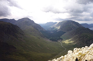
Green and Great Gable rise at the head of Ennerdale, the infant River Liza tumbling down from their connecting col
, Windy Gap. To their backs they have the walkers' pass of Sty Head, connecting Borrowdale
to Wasdale
. Green Gable has a footing in Borrowdale only, standing to the north of the pass. It is from Ennerdale that the fell achieves a peaked "gable
d" outline, although only the lower slopes could be considered green- the summit area being a desert of stones.
Taking Great Gable as the pivot of the Western Fells, the northward arm begins over Green Gable, before swinging round over Brandreth
and Haystacks to begin the long northern wall of Ennerdale. Green Gable also has a secondary ridge to the north east, culminating in the separate fell of Base Brown
.
Windy Gap (2,460 ft) stands a little way to the south west of the summit, at the bottom of a stony slope. On the Ennerdale side is Stone Cove- not named by chance, they are yards deep- while the south eastern descent leads down Aaron Slack. "Slack" is the dialect word for scree
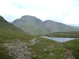
, and this too is a rough chute leading down to Sty Head Pass. Sty Head Tarn
lies at the bottom of the Slack, a large pool in a scooped out hollow, the outlet blocked by boulders. It is 30 ft deep and reputed to contain trout
.
Green Gable's eastern face contains the slight hollow of Mitchell Cove, its stream joining Styhead Gill on the way to Borrowdale. At the northern corner is the ridge to Base Brown, the flat topped depression of Blackmoor Pots. The dale between the Base Brown and Brandreth ridges is Gillercomb, a classic hanging valley. Its stream, Sour Milk Gill, exits around the nose of Base Brown via a series of cascades to Seathwaite. This ensures that all of Green Gable's waters, bar those from the western face, reach the River Derwent. Brandreth connects via the narrow ridge of Gillercomb Head, site of a few small pools after wet weather. The Ennerdale side provides the gentlest slopes, at least at lower levels, with the long grassy spur of Tongue gradually rising up the fell. The topmost section however is guarded by Greengable Crags, stretching around from Stone Cove.
, although there are outscops of the Long Top Member to the west and north. This comprises bedded and welded rhyolitic tuff
and lapilli
-tuff. Above Sty Head there are examples of Scafell dacite
and the tuffs and breccia
s of the Lingmell Formation. There is no history of mining on the fell.
and would be a famous spot in its own right but for the looming presence of Great Gable. The summit is the perfect position from which to admire Gable Crag, and in all other directions is undiminished in its view of the Lakeland fells. The view up the Buttermere
valley is perhaps the highlight.
road a contouring path runs around Grey Knotts
and Brandreth
, before ascending Green Gable via Gillercomb Head. This path can also be used to access Moses Trod, a high level route from Honister to Wasdale. "Moses" was a possibly apocryphal figure in local stories, a quarryman from Honister who doubled as a trader-cum-whisky smuggler between the Lakeland valleys.
A route from Seathwaite not designed for the ascent of Great Gable can be found by climbing up Styhead pass and then branching off into Mitchell Cove, following the beck almost to the summit. Aaron Slack can also be used. If starting from Ennerdale a long walk up the valley can culminate in either a climb up Stone Cove to Windy Gap, or a slightly easier ascent of the Tongue to reach Gillercomb Head. Indirect climbs via Brandreth or Base Brown are also possible.
Fell
“Fell” is a word used to refer to mountains, or certain types of mountainous landscape, in Scandinavia, the Isle of Man, and parts of northern England.- Etymology :...
in the English Lake District often traversed by walkers on route to its more famous neighbour Great Gable
Great Gable
Great Gable is a mountain lying at the very heart of the English Lake District, appearing as a pyramid from Wasdale , but as a dome from most other directions. It is one of the most popular of the Lakeland fells, and there are many different routes to the summit...
. It can be ascended from Honister Pass
Honister Pass
The Honister Pass, also known as Honister Hause, is a mountain pass in the English Lake District. It is located on the B5289 road, linking Seatoller, in the valley of Borrowdale, to Gatesgarth at the southern end of Buttermere...
, Seathwaite in Borrowdale
Borrowdale
Borrowdale is a valley and civil parish in the English Lake District in the Borough of Allerdale in Cumbria, England.Borrowdale lies within the historic county boundaries of Cumberland, and is sometimes referred to as Cumberland Borrowdale in order to distinguish it from another Borrowdale in the...
, or Ennerdale
Ennerdale
Ennerdale may refer to:* Ennerdale, Gauteng, a suburb of Johannesburg, South Africa* Ennerdale Water, a lake in the Lake District in England**Ennerdale Bridge, a nearby settlement...
. There are good views of Gable Crag, Scafell Pike
Scafell Pike
Scafell Pike is the highest mountain in England at . It is located in Lake District National Park sometimes confused with the neighbouring Sca Fell, to which it is connected by the col of Mickledore...
and the Buttermere
Buttermere
Buttermere is a lake in the English Lake District in North West England. The adjacent village of Buttermere takes its name from the lake. Historically within the former county of Cumberland, the lake is now within the county of Cumbria. It is owned by the National Trust, forming part of their...
valley from the summit.
Topography
The Western FellsWestern Fells
The Western Fells are a group of hills in the English Lake District. Centred on Great Gable they occupy a triangular area between Buttermere and Wasdale...
occupy a triangular sector of the Lake District, bordered by the River Cocker to the north east and Wasdale
Wasdale
Wasdale is a valley and civil parish in the western part of the Lake District National Park in Cumbria, England. The River Irt flows through the valley to its estuary at Ravenglass. A large part of the main valley floor is occupied by Wastwater, the deepest lake in England...
to the south east. Westwards the hills diminish toward the coastal plain of Cumberland. At the central hub of the high country are Great Gable and its satellites, while two principal ridges fan out on either flank of Ennerdale
Ennerdale
Ennerdale may refer to:* Ennerdale, Gauteng, a suburb of Johannesburg, South Africa* Ennerdale Water, a lake in the Lake District in England**Ennerdale Bridge, a nearby settlement...
, the western fells in effect being a great horseshoe around this long wild valley. Green Gable stands to the north east of its mightier sibling.
Green and Great Gable rise at the head of Ennerdale, the infant River Liza tumbling down from their connecting col
Mountain pass
A mountain pass is a route through a mountain range or over a ridge. If following the lowest possible route, a pass is locally the highest point on that route...
, Windy Gap. To their backs they have the walkers' pass of Sty Head, connecting Borrowdale
Borrowdale
Borrowdale is a valley and civil parish in the English Lake District in the Borough of Allerdale in Cumbria, England.Borrowdale lies within the historic county boundaries of Cumberland, and is sometimes referred to as Cumberland Borrowdale in order to distinguish it from another Borrowdale in the...
to Wasdale
Wasdale
Wasdale is a valley and civil parish in the western part of the Lake District National Park in Cumbria, England. The River Irt flows through the valley to its estuary at Ravenglass. A large part of the main valley floor is occupied by Wastwater, the deepest lake in England...
. Green Gable has a footing in Borrowdale only, standing to the north of the pass. It is from Ennerdale that the fell achieves a peaked "gable
Gable
A gable is the generally triangular portion of a wall between the edges of a sloping roof. The shape of the gable and how it is detailed depends on the structural system being used and aesthetic concerns. Thus the type of roof enclosing the volume dictates the shape of the gable...
d" outline, although only the lower slopes could be considered green- the summit area being a desert of stones.
Taking Great Gable as the pivot of the Western Fells, the northward arm begins over Green Gable, before swinging round over Brandreth
Brandreth
Brandreth is a fell in the English Lake District. It stands between Great Gable and Haystacks in the Western Fells.-Topography:The Western Fells occupy a triangular sector of the Lake District, bordered by the River Cocker to the north east and Wasdale to the south east. Westwards the hills...
and Haystacks to begin the long northern wall of Ennerdale. Green Gable also has a secondary ridge to the north east, culminating in the separate fell of Base Brown
Base Brown
Base Brown is a fell in England's Lake District, near the head of the Borrowdale Valley. It forms one side of the Seathwaite Valley, and on the western side it is flanked by the hanging valley of Gillercomb.-Topography:...
.
Windy Gap (2,460 ft) stands a little way to the south west of the summit, at the bottom of a stony slope. On the Ennerdale side is Stone Cove- not named by chance, they are yards deep- while the south eastern descent leads down Aaron Slack. "Slack" is the dialect word for scree
Scree
Scree, also called talus, is a term given to an accumulation of broken rock fragments at the base of crags, mountain cliffs, or valley shoulders. Landforms associated with these materials are sometimes called scree slopes or talus piles...
, and this too is a rough chute leading down to Sty Head Pass. Sty Head Tarn
Tarn (lake)
A tarn is a mountain lake or pool, formed in a cirque excavated by a glacier. A moraine may form a natural dam below a tarn. A corrie may be called a cirque.The word is derived from the Old Norse word tjörn meaning pond...
lies at the bottom of the Slack, a large pool in a scooped out hollow, the outlet blocked by boulders. It is 30 ft deep and reputed to contain trout
Trout
Trout is the name for a number of species of freshwater and saltwater fish belonging to the Salmoninae subfamily of the family Salmonidae. Salmon belong to the same family as trout. Most salmon species spend almost all their lives in salt water...
.
Green Gable's eastern face contains the slight hollow of Mitchell Cove, its stream joining Styhead Gill on the way to Borrowdale. At the northern corner is the ridge to Base Brown, the flat topped depression of Blackmoor Pots. The dale between the Base Brown and Brandreth ridges is Gillercomb, a classic hanging valley. Its stream, Sour Milk Gill, exits around the nose of Base Brown via a series of cascades to Seathwaite. This ensures that all of Green Gable's waters, bar those from the western face, reach the River Derwent. Brandreth connects via the narrow ridge of Gillercomb Head, site of a few small pools after wet weather. The Ennerdale side provides the gentlest slopes, at least at lower levels, with the long grassy spur of Tongue gradually rising up the fell. The topmost section however is guarded by Greengable Crags, stretching around from Stone Cove.
Geology
The summit of Green Gable is overlain by tillTill
thumb|right|Closeup of glacial till. Note that the larger grains in the till are completely surrounded by the matrix of finer material , and this characteristic, known as matrix support, is diagnostic of till....
, although there are outscops of the Long Top Member to the west and north. This comprises bedded and welded rhyolitic tuff
Tuff
Tuff is a type of rock consisting of consolidated volcanic ash ejected from vents during a volcanic eruption. Tuff is sometimes called tufa, particularly when used as construction material, although tufa also refers to a quite different rock. Rock that contains greater than 50% tuff is considered...
and lapilli
Lapilli
Lapilli is a size classification term for tephra, which is material that falls out of the air during a volcanic eruption or during some meteorite impacts. Lapilli means "little stones" in Latin. They are in some senses similar to ooids or pisoids in calcareous sediments.By definition lapilli range...
-tuff. Above Sty Head there are examples of Scafell dacite
Dacite
Dacite is an igneous, volcanic rock. It has an aphanitic to porphyritic texture and is intermediate in composition between andesite and rhyolite. The relative proportions of feldspars and quartz in dacite, and in many other volcanic rocks, are illustrated in the QAPF diagram...
and the tuffs and breccia
Breccia
Breccia is a rock composed of broken fragments of minerals or rock cemented together by a fine-grained matrix, that can be either similar to or different from the composition of the fragments....
s of the Lingmell Formation. There is no history of mining on the fell.
Summit and view
Green Gable has a neat summit marked by a cairnCairn
Cairn is a term used mainly in the English-speaking world for a man-made pile of stones. It comes from the or . Cairns are found all over the world in uplands, on moorland, on mountaintops, near waterways and on sea cliffs, and also in barren desert and tundra areas...
and would be a famous spot in its own right but for the looming presence of Great Gable. The summit is the perfect position from which to admire Gable Crag, and in all other directions is undiminished in its view of the Lakeland fells. The view up the Buttermere
Buttermere
Buttermere is a lake in the English Lake District in North West England. The adjacent village of Buttermere takes its name from the lake. Historically within the former county of Cumberland, the lake is now within the county of Cumbria. It is owned by the National Trust, forming part of their...
valley is perhaps the highlight.
Ascents
Some of the routes are those used for Great Gable, in particular those from the north. From Seathwaite a path runs up beside Sour Milk Gill into Gillercomb. From here it continues up the flank of the Blackmoor Pols ridge and onto the summit. From the top of the Honister PassHonister Pass
The Honister Pass, also known as Honister Hause, is a mountain pass in the English Lake District. It is located on the B5289 road, linking Seatoller, in the valley of Borrowdale, to Gatesgarth at the southern end of Buttermere...
road a contouring path runs around Grey Knotts
Grey Knotts
Grey Knotts is a fell in the English Lake District, it is situated one kilometre south of the B5289 road as it crosses the Honister Pass, it is well seen from mid Borrowdale as it rises above Seatoller...
and Brandreth
Brandreth
Brandreth is a fell in the English Lake District. It stands between Great Gable and Haystacks in the Western Fells.-Topography:The Western Fells occupy a triangular sector of the Lake District, bordered by the River Cocker to the north east and Wasdale to the south east. Westwards the hills...
, before ascending Green Gable via Gillercomb Head. This path can also be used to access Moses Trod, a high level route from Honister to Wasdale. "Moses" was a possibly apocryphal figure in local stories, a quarryman from Honister who doubled as a trader-cum-whisky smuggler between the Lakeland valleys.
A route from Seathwaite not designed for the ascent of Great Gable can be found by climbing up Styhead pass and then branching off into Mitchell Cove, following the beck almost to the summit. Aaron Slack can also be used. If starting from Ennerdale a long walk up the valley can culminate in either a climb up Stone Cove to Windy Gap, or a slightly easier ascent of the Tongue to reach Gillercomb Head. Indirect climbs via Brandreth or Base Brown are also possible.