
High Crag
Encyclopedia
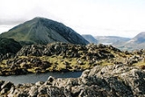
High Crag stands at the southern end of the High Stile
ridge which divides the valleys of Ennerdale
and Buttermere
in the west of the English Lake District. It is often climbed as part of a popular ridge walk, from Black Sail youth hostel, or from Buttermere via Scarth Gap. Panoramas of the Great Gable
and the Scafells
are visible.
occupy a triangular sector of the Lake District, bordered by the River Cocker to the north east and Wasdale
to the south east. Westwards the hills diminish toward the coastal plain of Cumberland. At the central hub of the high country are Great Gable
and its satellites, while two principal ridges fan out on either flank of Ennerdale
, the western fells in effect being a great horseshoe around this long wild valley. The highest section of the northern branch is formed by the trio of Buttermere
fells, High Crag, High Stile
and Red Pike
.
The Buttermere Fells, also known as Buttermere Edge, form the watershed between Buttermere
and Upper Ennerdale
. The Ennerdale flanks are steep and rough, put with only small areas of crag, the lower slopes being planted with a ribbon of conifers. Across the narrow ridge-top to the north are deep corrie
s and dark walls of crag, glowering down over the lake. The ridge continues south east to Haystacks and the Great Gable
group. Beyond Red Pike to the west are Starling Dodd
, Great Borne
and the Loweswater Fells.
High Crag forms the eastern terminus of the Buttermere Fells, its most arresting feature being the great scree slopes of Gamlin End where the high ground falls away. 700 ft below, the ridge levels out once more and throws up the craggy top of Seat (1,840 ft). A final steep descent then leads to Scarth Gap, a walkers' pass between Buttermere and Ennerdale.
All three Buttermere Fells throw out a rocky spur toward the lake, these walls enclosing Birkness and Bleaberry Combs. Birkness Comb, also called Burtness Comb on Ordnance Survey
maps, lies between the truncated and unnamed northern ridges of High Crag and High Stile. Drained into Buttermere
by Comb Beck, its headwall is rimmed by crags on all sides. Sheepbone Butress flanks High Crag, which also has a share in Comb Crags, lining the onward ridge. It is the great scooped hollow of the Comb which results in the narrowness of Buttermere Edge. The northern spur also ends abruptly as High Crag Butress, a further tier of rock lying just above the lakeshore.
-phyric andesite
lava
s. Interbeds of volcaniclastic sandstone
and lapilli
-tuff
also appear. Seat is an outcrop of the flow banded andesite lavas of the Haystacks Member, shot through with quartz
-feldspar
phyric microgranite
.
There was small scale mining activity in the late nineteenth century beneath Low Wax Knott, adjacent to the Scarth Gap path. Two men worked the operation, living on the fellside in a hut. A search was organised after their regular visits to the local hostelry abruptly ceased, and one was found dead in a pool at Warnscale. It was suspected that the other had killed him.
at the high point above Gamlin End. The view is restricted by High Stile
, but the head of Ennerdale
- backed by the Scafells
- presents a fine picture. More distant glimpses of Skiddaw
and the Helvellyn range
are also granted. A short walk north west toward the top of the crags brings Buttermere
and Crummock Water
into sight.
noted that an ascent may be made via Birkness Comb, climbing a grassy rake through the crags.
High Stile
High Stile is a mountain in the western part of the Lake District in northwest England. It is the eleventh highest English Marilyn, standing 807 metres high, and has a relative height of 362 metres ....
ridge which divides the valleys of Ennerdale
Ennerdale Water
Ennerdale Water is the most westerly lake in the Lake District National Park in Cumbria, England. It is a glacial lake, with a maximum depth of 45 metres , and at 700 to 1,500 metres wide and 3.9 kilometres is one of the smallest lakes in the area...
and Buttermere
Buttermere
Buttermere is a lake in the English Lake District in North West England. The adjacent village of Buttermere takes its name from the lake. Historically within the former county of Cumberland, the lake is now within the county of Cumbria. It is owned by the National Trust, forming part of their...
in the west of the English Lake District. It is often climbed as part of a popular ridge walk, from Black Sail youth hostel, or from Buttermere via Scarth Gap. Panoramas of the Great Gable
Great Gable
Great Gable is a mountain lying at the very heart of the English Lake District, appearing as a pyramid from Wasdale , but as a dome from most other directions. It is one of the most popular of the Lakeland fells, and there are many different routes to the summit...
and the Scafells
Scafells
Image:Annotated Scafell range.jpg|thumb|right|300px|The Scafell range as seen looking west from Crinkle Crags. rect 23 372 252 419 Slight Side rect 173 794 560 834 Scafell East Buttress...
are visible.
Topography
The Western FellsWestern Fells
The Western Fells are a group of hills in the English Lake District. Centred on Great Gable they occupy a triangular area between Buttermere and Wasdale...
occupy a triangular sector of the Lake District, bordered by the River Cocker to the north east and Wasdale
Wasdale
Wasdale is a valley and civil parish in the western part of the Lake District National Park in Cumbria, England. The River Irt flows through the valley to its estuary at Ravenglass. A large part of the main valley floor is occupied by Wastwater, the deepest lake in England...
to the south east. Westwards the hills diminish toward the coastal plain of Cumberland. At the central hub of the high country are Great Gable
Great Gable
Great Gable is a mountain lying at the very heart of the English Lake District, appearing as a pyramid from Wasdale , but as a dome from most other directions. It is one of the most popular of the Lakeland fells, and there are many different routes to the summit...
and its satellites, while two principal ridges fan out on either flank of Ennerdale
Ennerdale
Ennerdale may refer to:* Ennerdale, Gauteng, a suburb of Johannesburg, South Africa* Ennerdale Water, a lake in the Lake District in England**Ennerdale Bridge, a nearby settlement...
, the western fells in effect being a great horseshoe around this long wild valley. The highest section of the northern branch is formed by the trio of Buttermere
Buttermere
Buttermere is a lake in the English Lake District in North West England. The adjacent village of Buttermere takes its name from the lake. Historically within the former county of Cumberland, the lake is now within the county of Cumbria. It is owned by the National Trust, forming part of their...
fells, High Crag, High Stile
High Stile
High Stile is a mountain in the western part of the Lake District in northwest England. It is the eleventh highest English Marilyn, standing 807 metres high, and has a relative height of 362 metres ....
and Red Pike
Red Pike (Buttermere)
Red Pike is a fell in the High Stile range in the western English Lake District, which separates Ennerdale from the valley of Buttermere and Crummock Water. It is high...
.
The Buttermere Fells, also known as Buttermere Edge, form the watershed between Buttermere
Buttermere
Buttermere is a lake in the English Lake District in North West England. The adjacent village of Buttermere takes its name from the lake. Historically within the former county of Cumberland, the lake is now within the county of Cumbria. It is owned by the National Trust, forming part of their...
and Upper Ennerdale
Ennerdale
Ennerdale may refer to:* Ennerdale, Gauteng, a suburb of Johannesburg, South Africa* Ennerdale Water, a lake in the Lake District in England**Ennerdale Bridge, a nearby settlement...
. The Ennerdale flanks are steep and rough, put with only small areas of crag, the lower slopes being planted with a ribbon of conifers. Across the narrow ridge-top to the north are deep corrie
Cirque
Cirque may refer to:* Cirque, a geological formation* Makhtesh, an erosional landform found in the Negev desert of Israel and Sinai of Egypt*Cirque , an album by Biosphere* Cirque Corporation, a company that makes touchpads...
s and dark walls of crag, glowering down over the lake. The ridge continues south east to Haystacks and the Great Gable
Great Gable
Great Gable is a mountain lying at the very heart of the English Lake District, appearing as a pyramid from Wasdale , but as a dome from most other directions. It is one of the most popular of the Lakeland fells, and there are many different routes to the summit...
group. Beyond Red Pike to the west are Starling Dodd
Starling Dodd
Starling Dodd is a fell in the western part of the English Lake District, located between the valleys of Ennerdale and Buttermere, on the ridge between Great Borne to its west and Red Pike to its east...
, Great Borne
Great Borne
Great Borne is a fell in the English Lake District with a height of . It is a rather secluded hill situated at the western end of the long ridge which divides the Ennerdale and Buttermere valleys.-Name:...
and the Loweswater Fells.
High Crag forms the eastern terminus of the Buttermere Fells, its most arresting feature being the great scree slopes of Gamlin End where the high ground falls away. 700 ft below, the ridge levels out once more and throws up the craggy top of Seat (1,840 ft). A final steep descent then leads to Scarth Gap, a walkers' pass between Buttermere and Ennerdale.
All three Buttermere Fells throw out a rocky spur toward the lake, these walls enclosing Birkness and Bleaberry Combs. Birkness Comb, also called Burtness Comb on Ordnance Survey
Ordnance Survey
Ordnance Survey , an executive agency and non-ministerial government department of the Government of the United Kingdom, is the national mapping agency for Great Britain, producing maps of Great Britain , and one of the world's largest producers of maps.The name reflects its creation together with...
maps, lies between the truncated and unnamed northern ridges of High Crag and High Stile. Drained into Buttermere
Buttermere
Buttermere is a lake in the English Lake District in North West England. The adjacent village of Buttermere takes its name from the lake. Historically within the former county of Cumberland, the lake is now within the county of Cumbria. It is owned by the National Trust, forming part of their...
by Comb Beck, its headwall is rimmed by crags on all sides. Sheepbone Butress flanks High Crag, which also has a share in Comb Crags, lining the onward ridge. It is the great scooped hollow of the Comb which results in the narrowness of Buttermere Edge. The northern spur also ends abruptly as High Crag Butress, a further tier of rock lying just above the lakeshore.
Geology and Mining
The summit rocks are of the Birker Fell Formation, plagioclasePlagioclase
Plagioclase is an important series of tectosilicate minerals within the feldspar family. Rather than referring to a particular mineral with a specific chemical composition, plagioclase is a solid solution series, more properly known as the plagioclase feldspar series...
-phyric andesite
Andesite
Andesite is an extrusive igneous, volcanic rock, of intermediate composition, with aphanitic to porphyritic texture. In a general sense, it is the intermediate type between basalt and dacite. The mineral assemblage is typically dominated by plagioclase plus pyroxene and/or hornblende. Magnetite,...
lava
Lava
Lava refers both to molten rock expelled by a volcano during an eruption and the resulting rock after solidification and cooling. This molten rock is formed in the interior of some planets, including Earth, and some of their satellites. When first erupted from a volcanic vent, lava is a liquid at...
s. Interbeds of volcaniclastic sandstone
Sandstone
Sandstone is a sedimentary rock composed mainly of sand-sized minerals or rock grains.Most sandstone is composed of quartz and/or feldspar because these are the most common minerals in the Earth's crust. Like sand, sandstone may be any colour, but the most common colours are tan, brown, yellow,...
and lapilli
Lapilli
Lapilli is a size classification term for tephra, which is material that falls out of the air during a volcanic eruption or during some meteorite impacts. Lapilli means "little stones" in Latin. They are in some senses similar to ooids or pisoids in calcareous sediments.By definition lapilli range...
-tuff
Tuff
Tuff is a type of rock consisting of consolidated volcanic ash ejected from vents during a volcanic eruption. Tuff is sometimes called tufa, particularly when used as construction material, although tufa also refers to a quite different rock. Rock that contains greater than 50% tuff is considered...
also appear. Seat is an outcrop of the flow banded andesite lavas of the Haystacks Member, shot through with quartz
Quartz
Quartz is the second-most-abundant mineral in the Earth's continental crust, after feldspar. It is made up of a continuous framework of SiO4 silicon–oxygen tetrahedra, with each oxygen being shared between two tetrahedra, giving an overall formula SiO2. There are many different varieties of quartz,...
-feldspar
Feldspar
Feldspars are a group of rock-forming tectosilicate minerals which make up as much as 60% of the Earth's crust....
phyric microgranite
Granite
Granite is a common and widely occurring type of intrusive, felsic, igneous rock. Granite usually has a medium- to coarse-grained texture. Occasionally some individual crystals are larger than the groundmass, in which case the texture is known as porphyritic. A granitic rock with a porphyritic...
.
There was small scale mining activity in the late nineteenth century beneath Low Wax Knott, adjacent to the Scarth Gap path. Two men worked the operation, living on the fellside in a hut. A search was organised after their regular visits to the local hostelry abruptly ceased, and one was found dead in a pool at Warnscale. It was suspected that the other had killed him.
Summit and view
The triangular summit has a cairnCairn
Cairn is a term used mainly in the English-speaking world for a man-made pile of stones. It comes from the or . Cairns are found all over the world in uplands, on moorland, on mountaintops, near waterways and on sea cliffs, and also in barren desert and tundra areas...
at the high point above Gamlin End. The view is restricted by High Stile
High Stile
High Stile is a mountain in the western part of the Lake District in northwest England. It is the eleventh highest English Marilyn, standing 807 metres high, and has a relative height of 362 metres ....
, but the head of Ennerdale
Ennerdale
Ennerdale may refer to:* Ennerdale, Gauteng, a suburb of Johannesburg, South Africa* Ennerdale Water, a lake in the Lake District in England**Ennerdale Bridge, a nearby settlement...
- backed by the Scafells
Scafells
Image:Annotated Scafell range.jpg|thumb|right|300px|The Scafell range as seen looking west from Crinkle Crags. rect 23 372 252 419 Slight Side rect 173 794 560 834 Scafell East Buttress...
- presents a fine picture. More distant glimpses of Skiddaw
Skiddaw
Skiddaw is a mountain in the Lake District National Park in England. With a summit at 931 m above sea level it is the fourth highest mountain in England. It lies just north of the town of Keswick, Cumbria, and dominates the skyline in this part of the northern lakes...
and the Helvellyn range
Helvellyn range
Helvellyn range is the name given to a part of the Eastern Fells in the English Lake District, fell being the local word for hill. The name comes from Helvellyn, the highest point of the group....
are also granted. A short walk north west toward the top of the crags brings Buttermere
Buttermere
Buttermere is a lake in the English Lake District in North West England. The adjacent village of Buttermere takes its name from the lake. Historically within the former county of Cumberland, the lake is now within the county of Cumbria. It is owned by the National Trust, forming part of their...
and Crummock Water
Crummock Water
Crummock Water is a lake in the Lake District in Cumbria, North West England situated between Buttermere to the south and Loweswater to the north. Crummock Water is two and a half miles long, three quarters of a mile wide and 140ft deep. The River Cocker is considered to start at the north of the...
into sight.
Ascents
Scarth Gap can be gained from the head of Ennerdale, but this is a long walk from anywhere except Black Sail Youth Hostel. Scarth Gap provides the more regular approach from the Buttermere valley, parking being available at Gatesgarth. On the Buttermere side a path cuts off the corner at the top of the pass and removes the need to first ascend Seat, before the long assault on the screes of Gamlin End. From the shore of Buttermere WainwrightAlfred Wainwright
Alfred Wainwright MBE was a British fellwalker, guidebook author and illustrator. His seven-volume Pictorial Guide to the Lakeland Fells, published between 1955 and 1966 and consisting entirely of reproductions of his manuscript, has become the standard reference work to 214 of the fells of the...
noted that an ascent may be made via Birkness Comb, climbing a grassy rake through the crags.