
Great Borne
Encyclopedia
Great Borne is a fell
in the English Lake District
with a height of 616 m (2,021 ft). It is a rather secluded hill situated at the western end of the long ridge which divides the Ennerdale
and Buttermere
valleys.
ns actually referring to the fell as Herdus. However Bill Birkett
in his Complete Lakeland Fells gives Great Borne and Herdus the status of separate fells, with Herdus’ summit standing half a kilometre west of Great Borne with an altitude 562 m (1,843.8 ft). The meaning of Great Borne translates from the French language
meaning "Great Boundary" as in the 13th century the fell denoted the edge of the Loweswater
forest, an alternative meaning has been put forward as "Great Stream" from the southern Old English language with bourne
meaning a stream flowing from a spring.
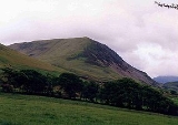
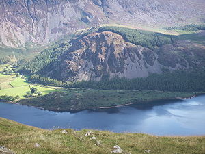 Great Borne's southern slopes are of some interest, they fall away precipitously towards Ennerdale Water with steep crags and scree
which are composed of pink granophyre
rock which give these slopes a reddish tinge (see picture). The outlying low summit of Bowness Knott (333 m (1,092.5 ft)) also lies to the south, it is composed of Skiddaw Slate
, it gives good views of Ennerdale Water and is an easy climb from the car park which lies at its foot. Historians have also found evidence of an old (possibly Middle Ages
) field system
on the lower southern slopes of Great Borne below the crags and scree. The northern flanks of the fell descend to the Floutern Pass, a pedestrian route between Ennerdale and Buttermere. To the east Great Borne is connected to the neighbouring fell of Starling Dodd
by a ridge, while the western slopes descend quickly to the low ground of the west Cumbrian plain.
series of guidebooks is currently challenged by a nearby farmer Mr Ireland who has a strong antipathy to walkers and the National Park
.
trig point
and a considerable wind shelter while the northern top has a large cairn
which is visible for miles around and gives extensive views of the Loweswater Fells
. This large cairn is thought to be the boundary marker from which the fell takes its name.
Fell
“Fell” is a word used to refer to mountains, or certain types of mountainous landscape, in Scandinavia, the Isle of Man, and parts of northern England.- Etymology :...
in the English Lake District
Lake District
The Lake District, also commonly known as The Lakes or Lakeland, is a mountainous region in North West England. A popular holiday destination, it is famous not only for its lakes and its mountains but also for its associations with the early 19th century poetry and writings of William Wordsworth...
with a height of 616 m (2,021 ft). It is a rather secluded hill situated at the western end of the long ridge which divides the Ennerdale
Ennerdale Water
Ennerdale Water is the most westerly lake in the Lake District National Park in Cumbria, England. It is a glacial lake, with a maximum depth of 45 metres , and at 700 to 1,500 metres wide and 3.9 kilometres is one of the smallest lakes in the area...
and Buttermere
Buttermere
Buttermere is a lake in the English Lake District in North West England. The adjacent village of Buttermere takes its name from the lake. Historically within the former county of Cumberland, the lake is now within the county of Cumbria. It is owned by the National Trust, forming part of their...
valleys.
Name
The name Great Borne only really applies to the fells summit area with most West CumbriaCumbria
Cumbria , is a non-metropolitan county in North West England. The county and Cumbria County Council, its local authority, came into existence in 1974 after the passage of the Local Government Act 1972. Cumbria's largest settlement and county town is Carlisle. It consists of six districts, and in...
ns actually referring to the fell as Herdus. However Bill Birkett
Bill Birkett
Bill Birkett is one of the world's foremost mountain writers and photographers, and is a leading climber who has undertaken many expeditions around the world....
in his Complete Lakeland Fells gives Great Borne and Herdus the status of separate fells, with Herdus’ summit standing half a kilometre west of Great Borne with an altitude 562 m (1,843.8 ft). The meaning of Great Borne translates from the French language
French language
French is a Romance language spoken as a first language in France, the Romandy region in Switzerland, Wallonia and Brussels in Belgium, Monaco, the regions of Quebec and Acadia in Canada, and by various communities elsewhere. Second-language speakers of French are distributed throughout many parts...
meaning "Great Boundary" as in the 13th century the fell denoted the edge of the Loweswater
Loweswater
Loweswater is one of the smaller lakes in the English Lake District. The village of Loweswater is situated at the foot of the lake.The lake is not far from Cockermouth and is also easily reached from elsewhere in West Cumbria. The group of fells to the south of Loweswater is known as the Loweswater...
forest, an alternative meaning has been put forward as "Great Stream" from the southern Old English language with bourne
Bourne
-General:*A winterbourne * Bourne , a surname*The Bourne shell, in Unix*Jason Bourne, a fictional character who is the protagonist of a trilogy of novels by Robert Ludlum and of a film series based on the books*Bourne Co...
meaning a stream flowing from a spring.
Topography and geology
Scree
Scree, also called talus, is a term given to an accumulation of broken rock fragments at the base of crags, mountain cliffs, or valley shoulders. Landforms associated with these materials are sometimes called scree slopes or talus piles...
which are composed of pink granophyre
Granophyre
Granophyre is a subvolcanic rock that contains quartz and alkali feldspar in characteristic angular intergrowths such as those in the accompanying image....
rock which give these slopes a reddish tinge (see picture). The outlying low summit of Bowness Knott (333 m (1,092.5 ft)) also lies to the south, it is composed of Skiddaw Slate
Skiddaw Slate
Skiddaw slate is an early Ordovician metamorphosed sedimentary rock, as first identified on the slopes of Skiddaw in the English Lake District....
, it gives good views of Ennerdale Water and is an easy climb from the car park which lies at its foot. Historians have also found evidence of an old (possibly Middle Ages
Middle Ages
The Middle Ages is a periodization of European history from the 5th century to the 15th century. The Middle Ages follows the fall of the Western Roman Empire in 476 and precedes the Early Modern Era. It is the middle period of a three-period division of Western history: Classic, Medieval and Modern...
) field system
Field system
The study of field systems in landscape history is concerned with the size, shape and orientation of a number of fields. These are often adjacent, but may be separated by a later feature.-Types of field system:...
on the lower southern slopes of Great Borne below the crags and scree. The northern flanks of the fell descend to the Floutern Pass, a pedestrian route between Ennerdale and Buttermere. To the east Great Borne is connected to the neighbouring fell of Starling Dodd
Starling Dodd
Starling Dodd is a fell in the western part of the English Lake District, located between the valleys of Ennerdale and Buttermere, on the ridge between Great Borne to its west and Red Pike to its east...
by a ridge, while the western slopes descend quickly to the low ground of the west Cumbrian plain.
Ascents
Great Borne is customarily climbed from the Ennerdale side of the fell, with the car park beneath Bowness Knott being the usual starting point. The route follows Rake Beck for a short distance and skirts the Herdus crags on the eastern side to gain the summit. An ascent using the Floutern Pass is not recommended as the top of the pass is very boggy and the route rather circuitous. The route described in the WainwrightAlfred Wainwright
Alfred Wainwright MBE was a British fellwalker, guidebook author and illustrator. His seven-volume Pictorial Guide to the Lakeland Fells, published between 1955 and 1966 and consisting entirely of reproductions of his manuscript, has become the standard reference work to 214 of the fells of the...
series of guidebooks is currently challenged by a nearby farmer Mr Ireland who has a strong antipathy to walkers and the National Park
Lake District National Park
The Lake District National Park is located in the north-west of England and is the largest of the English National Parks and the second largest in the United Kingdom. It is in the central and most-visited part of the Lake District....
.
Summit and view
The summit of the fell has two separate tops divided by a shallow valley, the south top is slightly higher and is marked by an Ordnance SurveyOrdnance Survey
Ordnance Survey , an executive agency and non-ministerial government department of the Government of the United Kingdom, is the national mapping agency for Great Britain, producing maps of Great Britain , and one of the world's largest producers of maps.The name reflects its creation together with...
trig point
Triangulation station
A triangulation station, also known as a triangulation pillar, trigonometrical station, trigonometrical point, trig station, trig beacon or trig point, and sometimes informally as a trig, is a fixed surveying station, used in geodetic surveying and other surveying projects in its vicinity...
and a considerable wind shelter while the northern top has a large cairn
Cairn
Cairn is a term used mainly in the English-speaking world for a man-made pile of stones. It comes from the or . Cairns are found all over the world in uplands, on moorland, on mountaintops, near waterways and on sea cliffs, and also in barren desert and tundra areas...
which is visible for miles around and gives extensive views of the Loweswater Fells
Loweswater, Cumbria
Loweswater is a village and civil parish in the county of Cumbria, England.-Village:The village lies between the Lake District lakes of Loweswater and Crummock Water, about south of Cockermouth and within the Lake District National Park...
. This large cairn is thought to be the boundary marker from which the fell takes its name.