
Buckbarrow
Encyclopedia
Buckbarrow is a small fell
in the English Lake District
situated at the western end of Wast Water
. It is featured in Alfred Wainwright
’s Pictorial Guide to the Lakeland Fells
and is given a height of 1,410 ft approximately; however, the Ordnance Survey
and other guide books now give an altitude of 423 m (1,388 ft). The fells name is means "The hill of the buck or goat". It is derived either from the Old English word "bucc" meaning buck or the Old Norse
word "bokki" meaning a male goat.
occupy a triangular sector of the Lake District, bordered by the River Cocker to the north east and Wasdale
to the south east. Westwards the hills diminish toward the coastal plain of Cumberland. At the central hub of the high country are Great Gable
and its satellites, while two principal ridges fan out on either flank of Ennerdale
, the western fells in effect being a great horseshoe around this long, wild valley. Buckbarrow is an outlier of the southern branch of the horseshoe.
Buckbarrow is not really a separate hill, but just the craggy end of the southern ridge of the neighbouring fell of Seatallan
, which reaches a height of 692 m (2,270 ft). Seatallan itself lies to the south of the main ridge, connecting to Haycock across the Pots of Ashness depression.
Seatallan's south western ridge falls gently at first across the broad green expanse of Nether Wasdale Common, finally narrowing to a point at Cat Bields (500 m or 1,640 ft), a mile from the summit. From here the slope continues in the same direction to the Greendale- Gosforth
road, its progress only briefly interrupted by the few desultory rocks of Gray Crag. A smaller spur runs out south from Cat Bields, only resolving into a definite ridge some way down the slope at Glade How (435 m or 1,425 ft). This cairn
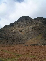
ed top is recognised as a summit by some guidbooks. A little to the south of Glade How the spur ends in a wall of crag, dropping 900 ft to the road below. This is Buckbarrow.
Buckbarrow's crags face the Wastwater Screes
across the foot of the lake, aping their more famous neighbours in miniature. About three quarters of a mile in length, the principal features of Buckbarrow's southern face are Long Crag, Pike Crag, Bull Crag and Broad Crag. The western boundary is formed by Gill Beck, flowing between Buckbarrow and the main ridge of Seatallan. To the east the crags overlook Greendale Gill, the boundary with Middle Fell
.
being in evidence around Glade How. The summit area shows outcropping of the Birker Fell Formation, an undivided sequence of generally plagioclase
-phyric andesite
lava
s with subordinate sills. At the bottom of the slope are examples of granophyric microgranite, representative of the Ennerdale Intrusion. Dykes of basalt
and dolerite run through both formations.
.
almost as an afterthought as the walker descends from Seatallan. Buckbarrow's formidable crags are a popular rock climbing venue.
Fell
“Fell” is a word used to refer to mountains, or certain types of mountainous landscape, in Scandinavia, the Isle of Man, and parts of northern England.- Etymology :...
in the English Lake District
Lake District
The Lake District, also commonly known as The Lakes or Lakeland, is a mountainous region in North West England. A popular holiday destination, it is famous not only for its lakes and its mountains but also for its associations with the early 19th century poetry and writings of William Wordsworth...
situated at the western end of Wast Water
Wast Water
Wast Water or Wastwater is a lake located in Wasdale, a valley in the western part of the Lake District National Park, England. The lake is approximately 4.6 kilometres long and 600 metres wide. It is the deepest lake in England at 79 metres , and is owned by the National Trust...
. It is featured in Alfred Wainwright
Alfred Wainwright
Alfred Wainwright MBE was a British fellwalker, guidebook author and illustrator. His seven-volume Pictorial Guide to the Lakeland Fells, published between 1955 and 1966 and consisting entirely of reproductions of his manuscript, has become the standard reference work to 214 of the fells of the...
’s Pictorial Guide to the Lakeland Fells
Pictorial Guide to the Lakeland Fells
A Pictorial Guide to the Lakeland Fells is a series of seven books by A. Wainwright, detailing the fells of the Lake District in northwest England...
and is given a height of 1,410 ft approximately; however, the Ordnance Survey
Ordnance Survey
Ordnance Survey , an executive agency and non-ministerial government department of the Government of the United Kingdom, is the national mapping agency for Great Britain, producing maps of Great Britain , and one of the world's largest producers of maps.The name reflects its creation together with...
and other guide books now give an altitude of 423 m (1,388 ft). The fells name is means "The hill of the buck or goat". It is derived either from the Old English word "bucc" meaning buck or the Old Norse
Old Norse
Old Norse is a North Germanic language that was spoken by inhabitants of Scandinavia and inhabitants of their overseas settlements during the Viking Age, until about 1300....
word "bokki" meaning a male goat.
Topography
The Western FellsWestern Fells
The Western Fells are a group of hills in the English Lake District. Centred on Great Gable they occupy a triangular area between Buttermere and Wasdale...
occupy a triangular sector of the Lake District, bordered by the River Cocker to the north east and Wasdale
Wasdale
Wasdale is a valley and civil parish in the western part of the Lake District National Park in Cumbria, England. The River Irt flows through the valley to its estuary at Ravenglass. A large part of the main valley floor is occupied by Wastwater, the deepest lake in England...
to the south east. Westwards the hills diminish toward the coastal plain of Cumberland. At the central hub of the high country are Great Gable
Great Gable
Great Gable is a mountain lying at the very heart of the English Lake District, appearing as a pyramid from Wasdale , but as a dome from most other directions. It is one of the most popular of the Lakeland fells, and there are many different routes to the summit...
and its satellites, while two principal ridges fan out on either flank of Ennerdale
Ennerdale
Ennerdale may refer to:* Ennerdale, Gauteng, a suburb of Johannesburg, South Africa* Ennerdale Water, a lake in the Lake District in England**Ennerdale Bridge, a nearby settlement...
, the western fells in effect being a great horseshoe around this long, wild valley. Buckbarrow is an outlier of the southern branch of the horseshoe.
Buckbarrow is not really a separate hill, but just the craggy end of the southern ridge of the neighbouring fell of Seatallan
Seatallan
Seatallan is a mountain in the western part of the English Lake District. It is rounded, grassy and fairly unassuming, occupying a large amount of land. However, it is classed as a Marilyn because of the low elevation of the col connecting it to Haycock, its nearest higher neighbour to the north...
, which reaches a height of 692 m (2,270 ft). Seatallan itself lies to the south of the main ridge, connecting to Haycock across the Pots of Ashness depression.
Seatallan's south western ridge falls gently at first across the broad green expanse of Nether Wasdale Common, finally narrowing to a point at Cat Bields (500 m or 1,640 ft), a mile from the summit. From here the slope continues in the same direction to the Greendale- Gosforth
Gosforth
Gosforth is an area of Newcastle upon Tyne, Tyne and Wear, England, United Kingdom, to the north of the city centre. Gosforth constituted an urban district from 1895 to 1974, when it became part of the City of Newcastle upon Tyne. It has a population of 23,620...
road, its progress only briefly interrupted by the few desultory rocks of Gray Crag. A smaller spur runs out south from Cat Bields, only resolving into a definite ridge some way down the slope at Glade How (435 m or 1,425 ft). This cairn
Cairn
Cairn is a term used mainly in the English-speaking world for a man-made pile of stones. It comes from the or . Cairns are found all over the world in uplands, on moorland, on mountaintops, near waterways and on sea cliffs, and also in barren desert and tundra areas...
ed top is recognised as a summit by some guidbooks. A little to the south of Glade How the spur ends in a wall of crag, dropping 900 ft to the road below. This is Buckbarrow.
Buckbarrow's crags face the Wastwater Screes
Whin Rigg
Whin Rigg is a fell is the English Lake District, situated in the western segment of the national park, 22 kilometres south east of the town of Whitehaven...
across the foot of the lake, aping their more famous neighbours in miniature. About three quarters of a mile in length, the principal features of Buckbarrow's southern face are Long Crag, Pike Crag, Bull Crag and Broad Crag. The western boundary is formed by Gill Beck, flowing between Buckbarrow and the main ridge of Seatallan. To the east the crags overlook Greendale Gill, the boundary with Middle Fell
Middle Fell
Middle Fell is a hill or fell in the English Lake District. It is a satellite of Seatallan standing above the northern shore of Wastwater. Middle Fell can be climbed from Greendale near the foot of Wastwater, and a fine view of the lake backed by the Wastwater Screes is visible from the...
.
Geology
The northern parts of Buckbarrow, blending into the slopes of Seatallan, are overlain by drift deposits, much peatPeat
Peat is an accumulation of partially decayed vegetation matter or histosol. Peat forms in wetland bogs, moors, muskegs, pocosins, mires, and peat swamp forests. Peat is harvested as an important source of fuel in certain parts of the world...
being in evidence around Glade How. The summit area shows outcropping of the Birker Fell Formation, an undivided sequence of generally plagioclase
Plagioclase
Plagioclase is an important series of tectosilicate minerals within the feldspar family. Rather than referring to a particular mineral with a specific chemical composition, plagioclase is a solid solution series, more properly known as the plagioclase feldspar series...
-phyric andesite
Andesite
Andesite is an extrusive igneous, volcanic rock, of intermediate composition, with aphanitic to porphyritic texture. In a general sense, it is the intermediate type between basalt and dacite. The mineral assemblage is typically dominated by plagioclase plus pyroxene and/or hornblende. Magnetite,...
lava
Lava
Lava refers both to molten rock expelled by a volcano during an eruption and the resulting rock after solidification and cooling. This molten rock is formed in the interior of some planets, including Earth, and some of their satellites. When first erupted from a volcanic vent, lava is a liquid at...
s with subordinate sills. At the bottom of the slope are examples of granophyric microgranite, representative of the Ennerdale Intrusion. Dykes of basalt
Basalt
Basalt is a common extrusive volcanic rock. It is usually grey to black and fine-grained due to rapid cooling of lava at the surface of a planet. It may be porphyritic containing larger crystals in a fine matrix, or vesicular, or frothy scoria. Unweathered basalt is black or grey...
and dolerite run through both formations.
Summit and View
The nearest to an actual summit given the limited prominence is a rocky mound set back from the rim of crags. Much finer views can be obtained from the lower rocky knoll which stands above Pike Crag.. Buckbarrow gives good views of Wast Water as well as the Wast Water Screes. The full length of the lake can be seen from Pike Crag, along with a fine view of Great Gable and the ScafellsScafells
Image:Annotated Scafell range.jpg|thumb|right|300px|The Scafell range as seen looking west from Crinkle Crags. rect 23 372 252 419 Slight Side rect 173 794 560 834 Scafell East Buttress...
.
Ascents
The fell is usually climbed from the minor road which runs along the base of the hill. From here Buckbarrow looks quite formidable and the crags are a deterrent to a direct ascent; however, all danger can be bypassed by starting the climb at the more westerly point of Harrow Head farm and following Gill Beck up to a height of around 350 m (1,150 ft) before bearing north easterly to the highest point above the crags. An alternative is to climb from Greendale, via Greendale Gill and Tongues Gills. Buckbarrow can also be baggedPeak bagging
Peak bagging is an activity in which hillwalkers and mountaineers attempt to reach the summit of some collection of peaks, usually those above some height in a particular region, or having a particular feature.Peak bagging can be distinguished from highpointing...
almost as an afterthought as the walker descends from Seatallan. Buckbarrow's formidable crags are a popular rock climbing venue.