
Crag Fell
Encyclopedia
Crag Fell is a hill in the English
Lake District
. It is part of the Lank Rigg
group, standing above Ennerdale Water
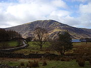
in the Western Fells. The craggy northern face above the lake gives the fell
its name, prominent in views from the car park at Bowness Knott. Ascents are commonly made from the foot of Ennerdale Water
.
occupy a triangular sector of the Lake District, bordered by the River Cocker to the north east and Wasdale
to the south east. Westwards the hills diminish toward the coastal plain of Cumberland. At the central hub of the high country are Great Gable
and its satellites, while two principal ridges fan out on either flank of Ennerdale
, the western fells in effect being a great horseshoe around this long wild valley. Crag Fell stands near the extremity of the southern arm.
The main watershed runs broadly westwards from Great Gable, dividing the headwaters of Ennerdale and Wasdale
. The fells in this section are Kirk Fell
, Pillar
, Scoat Fell
, Haycock and Caw Fell
. The surrounding valleys gradually diverge until other rivers spring up to drain the intervening country. Worm Gill is one such watercourse, running south westward from Caw Fell, and forcing the ridge to detour northwards around the head of its valley. Beyond this stand the fells of the Lank Rigg
group, the final high country within the National Park
. Crag Fell and Grike
complete the westward line of the ridge, whilst Lank Rigg lies to the south across the head of the River Calder.
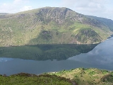
The northern flanks of Crag Fell tumble roughly down to the shore of Ennerdale Water. One tier of crags is directly below the summit, Revelin Crag being a notable feature, whilst a second abuts the lake itself. This is Anglers Crag, also known as Robin Hood's Chair. By contrast the southern slopes fall steadily to the headstream of the Calder, the lower section being planted with conifers.
South eastward from Crag Fell begins the long ridge to Caw Fell, first descending to a col
at 1,320 ft and then rising gently over the intermediate top of Iron Crag. To the west a narrower ridge runs along above the plantation to Grike. Crag Fell is bounded by Ben Gill in the west and Red Beck in the east.
described as the "grotesque collection of towers and minarets of the Calder Hall atomic power station".. The head of Ennerdale Water is seen to the east, surrounded by the high cirque of the Western Fells
. Distant Fairfield
and Ullscarf
put in unexpected appearances through the gaps.
England
England is a country that is part of the United Kingdom. It shares land borders with Scotland to the north and Wales to the west; the Irish Sea is to the north west, the Celtic Sea to the south west, with the North Sea to the east and the English Channel to the south separating it from continental...
Lake District
Lake District
The Lake District, also commonly known as The Lakes or Lakeland, is a mountainous region in North West England. A popular holiday destination, it is famous not only for its lakes and its mountains but also for its associations with the early 19th century poetry and writings of William Wordsworth...
. It is part of the Lank Rigg
Lank Rigg
Lank Rigg is a fell in the English Lake District. It stands to the south of Ennerdale in the Western Fells. A sprawling hill with gentle grassy slopes it can be climbed from various points on the Coldfell road...
group, standing above Ennerdale Water
Ennerdale Water
Ennerdale Water is the most westerly lake in the Lake District National Park in Cumbria, England. It is a glacial lake, with a maximum depth of 45 metres , and at 700 to 1,500 metres wide and 3.9 kilometres is one of the smallest lakes in the area...
in the Western Fells. The craggy northern face above the lake gives the fell
Fell
“Fell” is a word used to refer to mountains, or certain types of mountainous landscape, in Scandinavia, the Isle of Man, and parts of northern England.- Etymology :...
its name, prominent in views from the car park at Bowness Knott. Ascents are commonly made from the foot of Ennerdale Water
Ennerdale Water
Ennerdale Water is the most westerly lake in the Lake District National Park in Cumbria, England. It is a glacial lake, with a maximum depth of 45 metres , and at 700 to 1,500 metres wide and 3.9 kilometres is one of the smallest lakes in the area...
.
Topography
The Western FellsWestern Fells
The Western Fells are a group of hills in the English Lake District. Centred on Great Gable they occupy a triangular area between Buttermere and Wasdale...
occupy a triangular sector of the Lake District, bordered by the River Cocker to the north east and Wasdale
Wasdale
Wasdale is a valley and civil parish in the western part of the Lake District National Park in Cumbria, England. The River Irt flows through the valley to its estuary at Ravenglass. A large part of the main valley floor is occupied by Wastwater, the deepest lake in England...
to the south east. Westwards the hills diminish toward the coastal plain of Cumberland. At the central hub of the high country are Great Gable
Great Gable
Great Gable is a mountain lying at the very heart of the English Lake District, appearing as a pyramid from Wasdale , but as a dome from most other directions. It is one of the most popular of the Lakeland fells, and there are many different routes to the summit...
and its satellites, while two principal ridges fan out on either flank of Ennerdale
Ennerdale
Ennerdale may refer to:* Ennerdale, Gauteng, a suburb of Johannesburg, South Africa* Ennerdale Water, a lake in the Lake District in England**Ennerdale Bridge, a nearby settlement...
, the western fells in effect being a great horseshoe around this long wild valley. Crag Fell stands near the extremity of the southern arm.
The main watershed runs broadly westwards from Great Gable, dividing the headwaters of Ennerdale and Wasdale
Wasdale
Wasdale is a valley and civil parish in the western part of the Lake District National Park in Cumbria, England. The River Irt flows through the valley to its estuary at Ravenglass. A large part of the main valley floor is occupied by Wastwater, the deepest lake in England...
. The fells in this section are Kirk Fell
Kirk Fell
Kirk Fell is a fell in the Western part of the English Lake District. It is situated between Great Gable and Pillar on the long ring of fells surrounding the valley of Ennerdale, and also stands over Wasdale to the south...
, Pillar
Pillar (Lake District)
Pillar is a mountain in the western part of the English Lake District. Situated between the valleys of Ennerdale to the north and Wasdale to the south, it is the highest point of the Pillar group . At 892 metres it is the eighth highest mountain in the Lake District...
, Scoat Fell
Scoat Fell
Scoat Fell is a fell in the western part of the English Lake District. It stands at the head of the Mosedale Horseshoe with its back to Ennerdale...
, Haycock and Caw Fell
Caw Fell
Caw Fell is a fell in the English Lake District, standing between Haycock the Lank Rigg group. It occupies a wide upland area with Ennerdale to the north and Blengdale to the south...
. The surrounding valleys gradually diverge until other rivers spring up to drain the intervening country. Worm Gill is one such watercourse, running south westward from Caw Fell, and forcing the ridge to detour northwards around the head of its valley. Beyond this stand the fells of the Lank Rigg
Lank Rigg
Lank Rigg is a fell in the English Lake District. It stands to the south of Ennerdale in the Western Fells. A sprawling hill with gentle grassy slopes it can be climbed from various points on the Coldfell road...
group, the final high country within the National Park
Lake District National Park
The Lake District National Park is located in the north-west of England and is the largest of the English National Parks and the second largest in the United Kingdom. It is in the central and most-visited part of the Lake District....
. Crag Fell and Grike
Grike (Lake District)
Grike is a hill in the west of the English Lake District, near Ennerdale Water. It is part of the Lank Rigg group, the most westerly Wainwright as the fells diminish toward the coastal plain...
complete the westward line of the ridge, whilst Lank Rigg lies to the south across the head of the River Calder.
The northern flanks of Crag Fell tumble roughly down to the shore of Ennerdale Water. One tier of crags is directly below the summit, Revelin Crag being a notable feature, whilst a second abuts the lake itself. This is Anglers Crag, also known as Robin Hood's Chair. By contrast the southern slopes fall steadily to the headstream of the Calder, the lower section being planted with conifers.
South eastward from Crag Fell begins the long ridge to Caw Fell, first descending to a col
Mountain pass
A mountain pass is a route through a mountain range or over a ridge. If following the lowest possible route, a pass is locally the highest point on that route...
at 1,320 ft and then rising gently over the intermediate top of Iron Crag. To the west a narrower ridge runs along above the plantation to Grike. Crag Fell is bounded by Ben Gill in the west and Red Beck in the east.
Mining
The remains of a number of iron mines can be found above the shore of the lake. Small trials were driven beneath Revelin Crag, above Anglers Crag and on the upper eastern slopes above Red Beck. Although haematite was found, the quantities were never sufficient and all of the mines had closed by 1896.Summit and view
There are two mounds on the top of the fell, that to the north west being the summit. The whole area is undulating and grassy. There is a wide panorama to seaward, taking in what Alfred WainwrightAlfred Wainwright
Alfred Wainwright MBE was a British fellwalker, guidebook author and illustrator. His seven-volume Pictorial Guide to the Lakeland Fells, published between 1955 and 1966 and consisting entirely of reproductions of his manuscript, has become the standard reference work to 214 of the fells of the...
described as the "grotesque collection of towers and minarets of the Calder Hall atomic power station".. The head of Ennerdale Water is seen to the east, surrounded by the high cirque of the Western Fells
Western Fells
The Western Fells are a group of hills in the English Lake District. Centred on Great Gable they occupy a triangular area between Buttermere and Wasdale...
. Distant Fairfield
Fairfield (Lake District)
Fairfield is a fell in the English Lake District. It is the highest of a group of hills in the Eastern Fells, standing to the south of the Helvellyn range.-Topography:...
and Ullscarf
Ullscarf
Ullscarf is a fell in the English Lake District close to the geographical centre of the Cumbrian hills. It forms part of the watershed between the Derwentwater and Thirlmere catchments, a ridge running broadly north-south.-Topography:...
put in unexpected appearances through the gaps.