
Yewbarrow
Encyclopedia
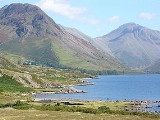
Yewbarrow is a fell
in the English Lake District which lies immediately north of the head of Wast Water
. It is 628 metres high and in shape resembles the upturned hull
of a boat or a barrow
. Yewbarrow is on the left in the classic view of Great Gable
and Wast Water.
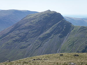
The top of Stirrup Crag forms a second summit 616 metres high, half a mile north of the main summit. The Hewitt and Nuttall lists classify the north top as a separate summit.
The name is derived from the past prevalence of yew
trees on the fell and its "barrow
" shape.
occupy a triangular sector of the Lake District, bordered by the River Cocker to the north east and Wasdale
to the south east. Westwards the hills diminish toward the coastal plain of Cumberland. At the central hub of the high country are Great Gable
and its satellites, while two principal ridges fan out on either flank of Ennerdale
, the western fells in effect being a great horseshoe around this long wild valley. Yewbarrow is an outlier of the southern arm.
The main watershed runs broadly westwards from Great Gable, dividing the headwaters of Ennerdale
and Wasdale
. Travelling in this direction the principal hills are Kirk Fell
, Pillar
, Scoat Fell
, Haycock and Caw Fell
. Scoat Fell throws out a long southern ridge terminating in Yewbarrow, with Red Pike
standing part way along.
The southern end of Yewbarrow rises steeply from the shore of Wastwater, the crest of the fell running a little east of north for about two miles. Just beyond the second top, the ridge swings sharply to the west at the depression of Dore Head (1,560 ft) continuing then onto Red Pike. The strath of Wasdale Head forms the eastern boundary of the fell with the quiet valley of Over Beck to the west. The ridge-top is rimmed by crags, particularly above Over Beck, and at either end. Stirrup Crag lies below the north summit, sometimes lending its name to the top, while Dropping Crag and Bell Rib guard the southern end of the crest.
, lapilli
-tuff and breccia
of the Lingmell Formation. The eastern slopes display the rhyolitic
rocks of the Long Top Member and Crinkle Member. The crags on the western face are outcrops of the plagioclase
-phyric andesite
lava
s of the Birker Fell Formation.
 Although smaller than the other fells surrounding Wasdale Head
— Scafell Pike
, Scafell, Great Gable
, Kirk Fell
and Pillar
— the ascent of Yewbarrow by the two traditional routes involves some scrambling. There are two primary ascents to Yewbarrow from Wasdale Head, via Overbeck Bridge and the Great Door (a cleft in the rocks providing thrilling views of Wast Water) or via Dore Head and Stirrup Crag. It is possible to circumvent almost all the scrambling on the route via Great Door by taking a path to the left of the major gully, and a cairned track without any scrambling runs up the west side from below Stirrup Crag to the minor col between the two tops of Yewbarrow.
It can also be climbed as part of the Mosedale Horseshoe, which can start or end at Yewbarrow and also includes Red Pike
, Scoat Fell
, Steeple
and Pillar.
set on grass, perhaps a surprise after the rough ascent.Yewbarrow is an excellent vantage point for the high fells in this part of the Lake District. Its unique location makes it the only place to enjoy uninterrupted views of the Scafells, Great Gable, Kirk Fell and Pillar.
Fell
“Fell” is a word used to refer to mountains, or certain types of mountainous landscape, in Scandinavia, the Isle of Man, and parts of northern England.- Etymology :...
in the English Lake District which lies immediately north of the head of Wast Water
Wast Water
Wast Water or Wastwater is a lake located in Wasdale, a valley in the western part of the Lake District National Park, England. The lake is approximately 4.6 kilometres long and 600 metres wide. It is the deepest lake in England at 79 metres , and is owned by the National Trust...
. It is 628 metres high and in shape resembles the upturned hull
Hull (watercraft)
A hull is the watertight body of a ship or boat. Above the hull is the superstructure and/or deckhouse, where present. The line where the hull meets the water surface is called the waterline.The structure of the hull varies depending on the vessel type...
of a boat or a barrow
Tumulus
A tumulus is a mound of earth and stones raised over a grave or graves. Tumuli are also known as barrows, burial mounds, Hügelgrab or kurgans, and can be found throughout much of the world. A tumulus composed largely or entirely of stones is usually referred to as a cairn...
. Yewbarrow is on the left in the classic view of Great Gable
Great Gable
Great Gable is a mountain lying at the very heart of the English Lake District, appearing as a pyramid from Wasdale , but as a dome from most other directions. It is one of the most popular of the Lakeland fells, and there are many different routes to the summit...
and Wast Water.
The top of Stirrup Crag forms a second summit 616 metres high, half a mile north of the main summit. The Hewitt and Nuttall lists classify the north top as a separate summit.
The name is derived from the past prevalence of yew
Taxus
Taxus is a genus of yews, small coniferous trees or shrubs in the yew family Taxaceae. They are relatively slow-growing and can be very long-lived, and reach heights of 1-40 m, with trunk diameters of up to 4 m...
trees on the fell and its "barrow
Tumulus
A tumulus is a mound of earth and stones raised over a grave or graves. Tumuli are also known as barrows, burial mounds, Hügelgrab or kurgans, and can be found throughout much of the world. A tumulus composed largely or entirely of stones is usually referred to as a cairn...
" shape.
Topography
The Western FellsWestern Fells
The Western Fells are a group of hills in the English Lake District. Centred on Great Gable they occupy a triangular area between Buttermere and Wasdale...
occupy a triangular sector of the Lake District, bordered by the River Cocker to the north east and Wasdale
Wasdale
Wasdale is a valley and civil parish in the western part of the Lake District National Park in Cumbria, England. The River Irt flows through the valley to its estuary at Ravenglass. A large part of the main valley floor is occupied by Wastwater, the deepest lake in England...
to the south east. Westwards the hills diminish toward the coastal plain of Cumberland. At the central hub of the high country are Great Gable
Great Gable
Great Gable is a mountain lying at the very heart of the English Lake District, appearing as a pyramid from Wasdale , but as a dome from most other directions. It is one of the most popular of the Lakeland fells, and there are many different routes to the summit...
and its satellites, while two principal ridges fan out on either flank of Ennerdale
Ennerdale
Ennerdale may refer to:* Ennerdale, Gauteng, a suburb of Johannesburg, South Africa* Ennerdale Water, a lake in the Lake District in England**Ennerdale Bridge, a nearby settlement...
, the western fells in effect being a great horseshoe around this long wild valley. Yewbarrow is an outlier of the southern arm.
The main watershed runs broadly westwards from Great Gable, dividing the headwaters of Ennerdale
Ennerdale
Ennerdale may refer to:* Ennerdale, Gauteng, a suburb of Johannesburg, South Africa* Ennerdale Water, a lake in the Lake District in England**Ennerdale Bridge, a nearby settlement...
and Wasdale
Wasdale
Wasdale is a valley and civil parish in the western part of the Lake District National Park in Cumbria, England. The River Irt flows through the valley to its estuary at Ravenglass. A large part of the main valley floor is occupied by Wastwater, the deepest lake in England...
. Travelling in this direction the principal hills are Kirk Fell
Kirk Fell
Kirk Fell is a fell in the Western part of the English Lake District. It is situated between Great Gable and Pillar on the long ring of fells surrounding the valley of Ennerdale, and also stands over Wasdale to the south...
, Pillar
Pillar (Lake District)
Pillar is a mountain in the western part of the English Lake District. Situated between the valleys of Ennerdale to the north and Wasdale to the south, it is the highest point of the Pillar group . At 892 metres it is the eighth highest mountain in the Lake District...
, Scoat Fell
Scoat Fell
Scoat Fell is a fell in the western part of the English Lake District. It stands at the head of the Mosedale Horseshoe with its back to Ennerdale...
, Haycock and Caw Fell
Caw Fell
Caw Fell is a fell in the English Lake District, standing between Haycock the Lank Rigg group. It occupies a wide upland area with Ennerdale to the north and Blengdale to the south...
. Scoat Fell throws out a long southern ridge terminating in Yewbarrow, with Red Pike
Red Pike (Wasdale)
Red Pike is a fell in the English Lake District. It is 826 m or high and lies due north of Wast Water. It is often climbed as part of the Mosedale Horseshoe, a walk which also includes Pillar....
standing part way along.
The southern end of Yewbarrow rises steeply from the shore of Wastwater, the crest of the fell running a little east of north for about two miles. Just beyond the second top, the ridge swings sharply to the west at the depression of Dore Head (1,560 ft) continuing then onto Red Pike. The strath of Wasdale Head forms the eastern boundary of the fell with the quiet valley of Over Beck to the west. The ridge-top is rimmed by crags, particularly above Over Beck, and at either end. Stirrup Crag lies below the north summit, sometimes lending its name to the top, while Dropping Crag and Bell Rib guard the southern end of the crest.
Geology
The summit is formed from the tuffTuff
Tuff is a type of rock consisting of consolidated volcanic ash ejected from vents during a volcanic eruption. Tuff is sometimes called tufa, particularly when used as construction material, although tufa also refers to a quite different rock. Rock that contains greater than 50% tuff is considered...
, lapilli
Lapilli
Lapilli is a size classification term for tephra, which is material that falls out of the air during a volcanic eruption or during some meteorite impacts. Lapilli means "little stones" in Latin. They are in some senses similar to ooids or pisoids in calcareous sediments.By definition lapilli range...
-tuff and breccia
Breccia
Breccia is a rock composed of broken fragments of minerals or rock cemented together by a fine-grained matrix, that can be either similar to or different from the composition of the fragments....
of the Lingmell Formation. The eastern slopes display the rhyolitic
Rhyolite
This page is about a volcanic rock. For the ghost town see Rhyolite, Nevada, and for the satellite system, see Rhyolite/Aquacade.Rhyolite is an igneous, volcanic rock, of felsic composition . It may have any texture from glassy to aphanitic to porphyritic...
rocks of the Long Top Member and Crinkle Member. The crags on the western face are outcrops of the plagioclase
Plagioclase
Plagioclase is an important series of tectosilicate minerals within the feldspar family. Rather than referring to a particular mineral with a specific chemical composition, plagioclase is a solid solution series, more properly known as the plagioclase feldspar series...
-phyric andesite
Andesite
Andesite is an extrusive igneous, volcanic rock, of intermediate composition, with aphanitic to porphyritic texture. In a general sense, it is the intermediate type between basalt and dacite. The mineral assemblage is typically dominated by plagioclase plus pyroxene and/or hornblende. Magnetite,...
lava
Lava
Lava refers both to molten rock expelled by a volcano during an eruption and the resulting rock after solidification and cooling. This molten rock is formed in the interior of some planets, including Earth, and some of their satellites. When first erupted from a volcanic vent, lava is a liquid at...
s of the Birker Fell Formation.
Ascents
Wasdale Head
Wasdale Head is a small agricultural village in the Lake District National Park in Cumbria, England. The village claims to be home of the highest mountain , deepest lake , smallest church and biggest liar in England...
— Scafell Pike
Scafell Pike
Scafell Pike is the highest mountain in England at . It is located in Lake District National Park sometimes confused with the neighbouring Sca Fell, to which it is connected by the col of Mickledore...
, Scafell, Great Gable
Great Gable
Great Gable is a mountain lying at the very heart of the English Lake District, appearing as a pyramid from Wasdale , but as a dome from most other directions. It is one of the most popular of the Lakeland fells, and there are many different routes to the summit...
, Kirk Fell
Kirk Fell
Kirk Fell is a fell in the Western part of the English Lake District. It is situated between Great Gable and Pillar on the long ring of fells surrounding the valley of Ennerdale, and also stands over Wasdale to the south...
and Pillar
Pillar (Lake District)
Pillar is a mountain in the western part of the English Lake District. Situated between the valleys of Ennerdale to the north and Wasdale to the south, it is the highest point of the Pillar group . At 892 metres it is the eighth highest mountain in the Lake District...
— the ascent of Yewbarrow by the two traditional routes involves some scrambling. There are two primary ascents to Yewbarrow from Wasdale Head, via Overbeck Bridge and the Great Door (a cleft in the rocks providing thrilling views of Wast Water) or via Dore Head and Stirrup Crag. It is possible to circumvent almost all the scrambling on the route via Great Door by taking a path to the left of the major gully, and a cairned track without any scrambling runs up the west side from below Stirrup Crag to the minor col between the two tops of Yewbarrow.
It can also be climbed as part of the Mosedale Horseshoe, which can start or end at Yewbarrow and also includes Red Pike
Red Pike (Wasdale)
Red Pike is a fell in the English Lake District. It is 826 m or high and lies due north of Wast Water. It is often climbed as part of the Mosedale Horseshoe, a walk which also includes Pillar....
, Scoat Fell
Scoat Fell
Scoat Fell is a fell in the western part of the English Lake District. It stands at the head of the Mosedale Horseshoe with its back to Ennerdale...
, Steeple
Steeple (Lake District)
Steeple is a fell in the English Lake District. It is situated in the mountainous area between Ennerdale and Wasdale and reaches a height of 819 metres . Steeple is really part of Scoat Fell, being just the rocky northern projection of that fell, however because of its prominent peak and steep...
and Pillar.
Summit and View
The summit bears a cairnCairn
Cairn is a term used mainly in the English-speaking world for a man-made pile of stones. It comes from the or . Cairns are found all over the world in uplands, on moorland, on mountaintops, near waterways and on sea cliffs, and also in barren desert and tundra areas...
set on grass, perhaps a surprise after the rough ascent.Yewbarrow is an excellent vantage point for the high fells in this part of the Lake District. Its unique location makes it the only place to enjoy uninterrupted views of the Scafells, Great Gable, Kirk Fell and Pillar.