
.gif)
Red Pike (Buttermere)
Encyclopedia
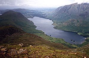
Red Pike is a fell
in the High Stile
range in the western English
Lake District
, which separates Ennerdale
from the valley of Buttermere
and Crummock Water
. It is 2476 ft (754.7 m) high. The direct ascent of Red Pike from Buttermere is very popular and the ridge walk from Red Pike to Haystacks is regarded as one of the finest in the area, with excellent views of the Scafells
, Great Gable
and Pillar
.
The fell can be confused with Red Pike (Wasdale)
, which is only three miles away but cannot be seen from the summit. Alfred Wainwright
in his guidebook The Western Fells comments that the Wasdale Red Pike might be higher but is less suited to the name. Red Pike in Buttermere is given its rich red colouring by the presence of syenite
in the rock and subsoil of the fell. This is particularly marked in places where surface erosion has occurred (notably the stony track by the side of Scale Force
and the path from Bleaberry Tarn
to the summit) and the red colouring of the paths can be seen from some distance.
occupy a triangular sector of the Lake District, bordered by the River Cocker to the north east and Wasdale
to the south east. Westwards the hills diminish toward the coastal plain of Cumberland. At the central hub of the high country are Great Gable
and its satellites, while two principal ridges fan out on either flank of Ennerdale
, the western fells in effect being a great horseshoe around this long wild valley. The highest section of the northern branch is formed by the trio of Buttermere
fells, High Crag
, High Stile
and Red Pike.
The Buttermere Fells, also known as Buttermere Edge, form the watershed between Buttermere
and Upper Ennerdale
. The Ennerdale flanks are steep and rough with areas of crag, the lower slopes being planted with a ribbon of conifers. Across the narrow ridge-top to the north are deep corrie
s and dark walls of crag, glowering down over the lake. The ridge continues south east to Haystacks and the Great Gable group. Beyond Red Pike to the west are Starling Dodd
, Great Borne
and the Loweswater Fells.
All three Buttermere Fells throw out a short spur towards the lake with deep combs hollowed out between them. Between Red Pike and High Stile is Bleaberry Comb, backed by Chapel Crags. Nestled deep within is Bleaberry Tarn, a pool which is in continual shadow from November to March. Despite the steep contours of the rock walls above, the tarn is only about 15 ft (4.6 m) deep, and is well stocked with trout.. Bleaberry Tarn is drained into Buttermere by Sourmilk Gill, reaching the lake mere yards from its outlet. A belt of trees has been planted along the shoreline. Of the three Buttermere Fells, only Red Pike's north east ridge ends in a prominent top with sufficient relative height to be listed as a Nuttall in its own right. This is Dodd, and the ridge connecting it to Red Pike is the Saddle.
The ongoing Ennerdale watershed continues westwards from Red Pike, losings its rocky character to become a broad grassy ridge. Little Dodd (1,935 ft) is crossed first, before the grassy dome of Starling Dodd is reached. Red Pike also throws out a northern ridge on this flank, descending via Lincomb edge toward Crummock Water, the final drop being over Blea Crag. Between Lingcomb Edge and Dodd is Ling Comb, the third corrie on the Buttermere flank of these fells, standing opposite the village. Behind Lingcomb Edge, separating Red Pike from Starling Dodd, is the valley of Scale Beck. This includes Scale Force, Lakeland's longest single drop waterfall at around 100 ft (30.5 m). The Ennerdale slopes are steep, cut by the valley of Gillflinter Beck. There are small areas of crag.
of the Ennerdale intrusion..
. Red Pike is unusual for the number of lakes in view- Derwentwater, Buttermere
, Crummock Water
, Ennerdale Water
and Loweswater
are all on display. Other highlights include Pillar Rock
, Grasmoor
and the close-up view of Chapel Crags.
Fell
“Fell” is a word used to refer to mountains, or certain types of mountainous landscape, in Scandinavia, the Isle of Man, and parts of northern England.- Etymology :...
in the High Stile
High Stile
High Stile is a mountain in the western part of the Lake District in northwest England. It is the eleventh highest English Marilyn, standing 807 metres high, and has a relative height of 362 metres ....
range in the western English
England
England is a country that is part of the United Kingdom. It shares land borders with Scotland to the north and Wales to the west; the Irish Sea is to the north west, the Celtic Sea to the south west, with the North Sea to the east and the English Channel to the south separating it from continental...
Lake District
Lake District
The Lake District, also commonly known as The Lakes or Lakeland, is a mountainous region in North West England. A popular holiday destination, it is famous not only for its lakes and its mountains but also for its associations with the early 19th century poetry and writings of William Wordsworth...
, which separates Ennerdale
Ennerdale Water
Ennerdale Water is the most westerly lake in the Lake District National Park in Cumbria, England. It is a glacial lake, with a maximum depth of 45 metres , and at 700 to 1,500 metres wide and 3.9 kilometres is one of the smallest lakes in the area...
from the valley of Buttermere
Buttermere
Buttermere is a lake in the English Lake District in North West England. The adjacent village of Buttermere takes its name from the lake. Historically within the former county of Cumberland, the lake is now within the county of Cumbria. It is owned by the National Trust, forming part of their...
and Crummock Water
Crummock Water
Crummock Water is a lake in the Lake District in Cumbria, North West England situated between Buttermere to the south and Loweswater to the north. Crummock Water is two and a half miles long, three quarters of a mile wide and 140ft deep. The River Cocker is considered to start at the north of the...
. It is 2476 ft (754.7 m) high. The direct ascent of Red Pike from Buttermere is very popular and the ridge walk from Red Pike to Haystacks is regarded as one of the finest in the area, with excellent views of the Scafells
Scafells
Image:Annotated Scafell range.jpg|thumb|right|300px|The Scafell range as seen looking west from Crinkle Crags. rect 23 372 252 419 Slight Side rect 173 794 560 834 Scafell East Buttress...
, Great Gable
Great Gable
Great Gable is a mountain lying at the very heart of the English Lake District, appearing as a pyramid from Wasdale , but as a dome from most other directions. It is one of the most popular of the Lakeland fells, and there are many different routes to the summit...
and Pillar
Pillar (Lake District)
Pillar is a mountain in the western part of the English Lake District. Situated between the valleys of Ennerdale to the north and Wasdale to the south, it is the highest point of the Pillar group . At 892 metres it is the eighth highest mountain in the Lake District...
.
The fell can be confused with Red Pike (Wasdale)
Red Pike (Wasdale)
Red Pike is a fell in the English Lake District. It is 826 m or high and lies due north of Wast Water. It is often climbed as part of the Mosedale Horseshoe, a walk which also includes Pillar....
, which is only three miles away but cannot be seen from the summit. Alfred Wainwright
Alfred Wainwright
Alfred Wainwright MBE was a British fellwalker, guidebook author and illustrator. His seven-volume Pictorial Guide to the Lakeland Fells, published between 1955 and 1966 and consisting entirely of reproductions of his manuscript, has become the standard reference work to 214 of the fells of the...
in his guidebook The Western Fells comments that the Wasdale Red Pike might be higher but is less suited to the name. Red Pike in Buttermere is given its rich red colouring by the presence of syenite
Syenite
Syenite is a coarse-grained intrusive igneous rock of the same general composition as granite but with the quartz either absent or present in relatively small amounts Syenite is a coarse-grained intrusive igneous rock of the same general composition as granite but with the quartz either absent or...
in the rock and subsoil of the fell. This is particularly marked in places where surface erosion has occurred (notably the stony track by the side of Scale Force
Scale Force
Scale Force is considered the highest waterfall in the English Lake District. Opinions can vary about how its precise height is calculated, but the total height is normally stated as 170 feet , with a single drop of water of 120 feet and several smaller drops...
and the path from Bleaberry Tarn
Bleaberry Tarn
Bleaberry Tarn is a small natural mountain tarn near Buttermere in the English Lake District. Located at NY165154 , it lies in a corrie below the Lakeland fells of Red Pike and High Stile, backed by Chapel Crags on the ridge between them...
to the summit) and the red colouring of the paths can be seen from some distance.
Topography
The Western FellsWestern Fells
The Western Fells are a group of hills in the English Lake District. Centred on Great Gable they occupy a triangular area between Buttermere and Wasdale...
occupy a triangular sector of the Lake District, bordered by the River Cocker to the north east and Wasdale
Wasdale
Wasdale is a valley and civil parish in the western part of the Lake District National Park in Cumbria, England. The River Irt flows through the valley to its estuary at Ravenglass. A large part of the main valley floor is occupied by Wastwater, the deepest lake in England...
to the south east. Westwards the hills diminish toward the coastal plain of Cumberland. At the central hub of the high country are Great Gable
Great Gable
Great Gable is a mountain lying at the very heart of the English Lake District, appearing as a pyramid from Wasdale , but as a dome from most other directions. It is one of the most popular of the Lakeland fells, and there are many different routes to the summit...
and its satellites, while two principal ridges fan out on either flank of Ennerdale
Ennerdale
Ennerdale may refer to:* Ennerdale, Gauteng, a suburb of Johannesburg, South Africa* Ennerdale Water, a lake in the Lake District in England**Ennerdale Bridge, a nearby settlement...
, the western fells in effect being a great horseshoe around this long wild valley. The highest section of the northern branch is formed by the trio of Buttermere
Buttermere
Buttermere is a lake in the English Lake District in North West England. The adjacent village of Buttermere takes its name from the lake. Historically within the former county of Cumberland, the lake is now within the county of Cumbria. It is owned by the National Trust, forming part of their...
fells, High Crag
High Crag
High Crag stands at the southern end of the High Stile ridge which divides the valleys of Ennerdale and Buttermere in the west of the English Lake District. It is often climbed as part of a popular ridge walk, from Black Sail youth hostel, or from Buttermere via Scarth Gap...
, High Stile
High Stile
High Stile is a mountain in the western part of the Lake District in northwest England. It is the eleventh highest English Marilyn, standing 807 metres high, and has a relative height of 362 metres ....
and Red Pike.
The Buttermere Fells, also known as Buttermere Edge, form the watershed between Buttermere
Buttermere
Buttermere is a lake in the English Lake District in North West England. The adjacent village of Buttermere takes its name from the lake. Historically within the former county of Cumberland, the lake is now within the county of Cumbria. It is owned by the National Trust, forming part of their...
and Upper Ennerdale
Ennerdale
Ennerdale may refer to:* Ennerdale, Gauteng, a suburb of Johannesburg, South Africa* Ennerdale Water, a lake in the Lake District in England**Ennerdale Bridge, a nearby settlement...
. The Ennerdale flanks are steep and rough with areas of crag, the lower slopes being planted with a ribbon of conifers. Across the narrow ridge-top to the north are deep corrie
Cirque
Cirque may refer to:* Cirque, a geological formation* Makhtesh, an erosional landform found in the Negev desert of Israel and Sinai of Egypt*Cirque , an album by Biosphere* Cirque Corporation, a company that makes touchpads...
s and dark walls of crag, glowering down over the lake. The ridge continues south east to Haystacks and the Great Gable group. Beyond Red Pike to the west are Starling Dodd
Starling Dodd
Starling Dodd is a fell in the western part of the English Lake District, located between the valleys of Ennerdale and Buttermere, on the ridge between Great Borne to its west and Red Pike to its east...
, Great Borne
Great Borne
Great Borne is a fell in the English Lake District with a height of . It is a rather secluded hill situated at the western end of the long ridge which divides the Ennerdale and Buttermere valleys.-Name:...
and the Loweswater Fells.
All three Buttermere Fells throw out a short spur towards the lake with deep combs hollowed out between them. Between Red Pike and High Stile is Bleaberry Comb, backed by Chapel Crags. Nestled deep within is Bleaberry Tarn, a pool which is in continual shadow from November to March. Despite the steep contours of the rock walls above, the tarn is only about 15 ft (4.6 m) deep, and is well stocked with trout.. Bleaberry Tarn is drained into Buttermere by Sourmilk Gill, reaching the lake mere yards from its outlet. A belt of trees has been planted along the shoreline. Of the three Buttermere Fells, only Red Pike's north east ridge ends in a prominent top with sufficient relative height to be listed as a Nuttall in its own right. This is Dodd, and the ridge connecting it to Red Pike is the Saddle.
The ongoing Ennerdale watershed continues westwards from Red Pike, losings its rocky character to become a broad grassy ridge. Little Dodd (1,935 ft) is crossed first, before the grassy dome of Starling Dodd is reached. Red Pike also throws out a northern ridge on this flank, descending via Lincomb edge toward Crummock Water, the final drop being over Blea Crag. Between Lingcomb Edge and Dodd is Ling Comb, the third corrie on the Buttermere flank of these fells, standing opposite the village. Behind Lingcomb Edge, separating Red Pike from Starling Dodd, is the valley of Scale Beck. This includes Scale Force, Lakeland's longest single drop waterfall at around 100 ft (30.5 m). The Ennerdale slopes are steep, cut by the valley of Gillflinter Beck. There are small areas of crag.
Geology
Red Pike is formed predominantly by the granophyric graniteGranite
Granite is a common and widely occurring type of intrusive, felsic, igneous rock. Granite usually has a medium- to coarse-grained texture. Occasionally some individual crystals are larger than the groundmass, in which case the texture is known as porphyritic. A granitic rock with a porphyritic...
of the Ennerdale intrusion..
Summit and View
The prominent curve of the summit stands out at the head of The Saddle, appearing quite magnificent from Crummock when High Stile is hidden. Top is shear on three sides, but well grassed and bears a large cairnCairn
Cairn is a term used mainly in the English-speaking world for a man-made pile of stones. It comes from the or . Cairns are found all over the world in uplands, on moorland, on mountaintops, near waterways and on sea cliffs, and also in barren desert and tundra areas...
. Red Pike is unusual for the number of lakes in view- Derwentwater, Buttermere
Buttermere
Buttermere is a lake in the English Lake District in North West England. The adjacent village of Buttermere takes its name from the lake. Historically within the former county of Cumberland, the lake is now within the county of Cumbria. It is owned by the National Trust, forming part of their...
, Crummock Water
Crummock Water
Crummock Water is a lake in the Lake District in Cumbria, North West England situated between Buttermere to the south and Loweswater to the north. Crummock Water is two and a half miles long, three quarters of a mile wide and 140ft deep. The River Cocker is considered to start at the north of the...
, Ennerdale Water
Ennerdale Water
Ennerdale Water is the most westerly lake in the Lake District National Park in Cumbria, England. It is a glacial lake, with a maximum depth of 45 metres , and at 700 to 1,500 metres wide and 3.9 kilometres is one of the smallest lakes in the area...
and Loweswater
Loweswater
Loweswater is one of the smaller lakes in the English Lake District. The village of Loweswater is situated at the foot of the lake.The lake is not far from Cockermouth and is also easily reached from elsewhere in West Cumbria. The group of fells to the south of Loweswater is known as the Loweswater...
are all on display. Other highlights include Pillar Rock
Pillar (Lake District)
Pillar is a mountain in the western part of the English Lake District. Situated between the valleys of Ennerdale to the north and Wasdale to the south, it is the highest point of the Pillar group . At 892 metres it is the eighth highest mountain in the Lake District...
, Grasmoor
Grasmoor
Grasmoor is a mountain in the north-western part of the Lake District, northern England. It is the highest peak in a group of hills between the villages of Lorton, Braithwaite and Buttermere, and overlooks Crummock Water....
and the close-up view of Chapel Crags.