
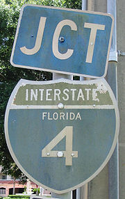
Interstate 4
Encyclopedia
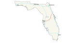
Interstate 4 is a 132.298 miles (212.9 km) intrastate Highway located entirely within the state of Florida
, United States
. It goes from Interstate 275
in Tampa, Florida
(27.965°N 82.453°W) to Interstate 95
at Daytona Beach, Florida
(29.155°N 81.076°W). It also has the Florida Department of Transportation
designation of State Road 400, but only a small portion of the route is signed at the east end. I-4 is currently the lowest-numbered Interstate Highway within the contiguous 48 U.S. state
s. The area that surrounds I-4 is often referred to as the I-4 Corridor.
in Tampa
and continues east toward I-75.
After passing through the eastern suburbs of Hillsborough County
, it crosses into Polk County
, entering the Lakeland
area, intersecting with the Polk Parkway twice before entering Polk City
.
At this point, the interstate starts a turn toward the northeast where it intersects with the Orlando
area cutting the city through at a diagonal direction going northeast/southwest. The route provides access to all of Orlando's theme parks including Disney World and Universal Studios
, as well as nearly all of Orlando's toll road
s, including Florida's Turnpike
. Throughout most of Orange County
and Seminole County
, I-4 travels in a roughly north–south direction. This causes endless trepidations for outsiders, since the exits are named according to I-4's generally west–east orientation.
 Right before the eastern terminus, I-4 switches to a mostly east–west route in order to connect with traffic from and to I-95
. At an interchange with I-95 in Daytona Beach, I-4 terminates; however, SR 400 continues eastward into Daytona Beach.
SR 400, unsigned while concurrent with I-4, becomes signed east of I-95. The road extends for three miles (5 km) from the northeast terminus of I-4, on the south side of Daytona International Speedway
and Daytona Beach International Airport
, to an intersection with U.S. Route 1
(SR 5) in Daytona Beach
. Named Beville Road, it runs along the boundary between the cities of Daytona Beach
and South Daytona
. The sections of Beville Road (the local name of SR 400), where it runs through the city, is classified a "Scenic Thoroughfare" by the City of Daytona Beach.
was opened to traffic, as well as the segment from the Hillsborough Avenue/ US 301 junction in Tampa to Plant City. The stretch from Lake Monroe to Lake Helen, including the original St. Johns River Bridge
also opened during that period. The segment from Lakeland to Orlando was complete by 1962. By the mid 1960s, several segments were already complete, including Malfunction Junction
in Tampa and parts of I-4 through Orlando. The original western terminus was set in South Pasadena
in the late 1960s, but this plan was rejected due to local opposition. As a result, I-4 went southwest only to 9th St N in St. Petersburg.
The entire Interstate Highway was completed by the late 1960s, however, the western terminus was truncated to Malfunction Junction
in 1971 when I-75 was extended over the Frankland Bridge. Eventually, that stretch was again redesignated to become part of I-275
.
In maps and atlases dating to the 1950s, 1960s, and 1970s, The Tampa/St. Petersburg section of Interstate 4/Interstate 275 was marked as the Tampa Expressway. The Orlando segment was marked as the Orlando Expressway. Both names have since faded from maps.
Although many post-1970 interchanges along I-4 were constructed before the recent widening projects, they were designed with I-4 expansion in mind. In other words, there is enough room available to widen I-4 to up to ten lanes without extensively modifying the interchanges. Some of these interchanges include the Interstate 75 stack (constructed in the 1980s) and several interchanges serving the Walt Disney World Resort
(constructed in the late 1980s/early 1990s).
In 2002, I-4, along with most of Florida's interstates, switched over from a sequential exit numbering system to a mileage based exit numbering system.
In the 2004 U.S. presidential election, the I-4 corridor, a site of significant growth, was a focus of political activity within the swing state
of Florida. Communities along the I-4 corridor were perceived by both major political parties as having higher proportions of undecided voters as compared to more Republican- or Democratic-leaning portions of the state. It played an equally key role in the 2008 U.S. presidential election, but whereas the corridor had voted heavily for Bush in 2004, which helped Bush win the state, in 2008 it swung behind Democratic candidate Obama, helping Obama win Florida.
A section of I-4 between Daytona Beach and Orlando called the 'dead zone' is rumored to be haunted. In 2010, the ECFRPC using GIS technology performed an analysis to determine if this identified zone had an increased fatality rate related to crashes. The analysis which compared this section of I-4 to several other dangerous I-4 sections found that while the dead zone area did not have the highest accident or fatality rate, it did identify that the percentage of fatality to accident was significantly higher in this location. In other words, while you are not more likely to be in accident in this section of I-4, if an accident occurs the chance of that accident containing a fatality is greatly increased.
) was rebuilt from 2002 to 2006, and I-4 is under staged renovations to be widened from four to six lanes (with eight lanes in certain segments). Much of this work is complete, and all new travel lanes are now open. Eventually, I-4 will be widened again to a total of at least ten lanes (five in each direction). Studies for this project are already underway and construction should commence sometime in the 2010s. Completion of the project should be around 2020.
 Eastbound I-4 shifted to its new, permanent alignment between Malfunction Junction
and 50th St on Tuesday, August 8, 2006 at 5:30 am. The new alignment includes a right-lane ramp exit/entry at the 22nd St/21st St Interchange (The previous left-lane configuration was causing hazardous conditions to commuters since its opening in 2005). On Friday, August 11, 2006, a fourth lane opened on eastbound I-4 between the downtown junction and 50th St (led in by a newly opened third lane on the eastbound I-4 ramp from northbound I-275). And on Friday, August 18, the new westbound alignment, just west of 50th Street, opened. The newly opened lanes will improve flow throughout the interchange. The 50th St overpass however, will not be complete until late 2007. Also, the eastbound I-4 exit ramp to Columbus Drive/50th Street is situated to the left-hand side of the highway (as opposed to its former right-hand side exit). This exit shift went into effect in spring 2006 and is part of the new, permanent interstate configuration.
In Tampa, the exit to 40th Street (State Road 569) has been closed since late 2005 due to the ongoing reconstruction of I-4; it will not reopen due to a proposed connector highway with the Lee Roy Selmon Expressway.
The interchange with what is today Interstate 75 was constructed in the early 1980s.
 In the early/mid 1990s, several interchanges near Kissimmee
were constructed/upgraded to accommodate increasing traffic going to and from Walt Disney World. However, I-4's main lanes were not widened in the process. Around the same time, the Southern Connector
was extended to I-4.
The St. Johns River Veterans Memorial Bridge
, a two-span six-lane replacement to the original four-lane bridge over the St. Johns River
northeast of Orlando, was completed in 2004.
During the early 2000s, tolled
express lanes were being planned in the Orlando area as a traffic congestion relief technique for rush hour
commuters. The name for them was to be Xpress 400, numbered after the state road designation for I-4, SR 400. The express lanes were slated to extend from Universal Orlando, east to SR 434 in Longwood
, and tolls were to be collected electronically
via transponders like SunPass
and Orlando-Orange County Expressway Authority
's E-Pass, with prices dependent on the congestion of the eight main lanes. However, the project was effectively banned by the passage of the SAFETEA-LU
Federal transportation bill in 2005, introduced by U.S. Representative
John Mica
. The plan for tolled express lanes, however, is still in the long term plans for I-4.
The eastbound exit to Robinson Street (State Road 526) permanently closed at 11PM on April 25, 2006, to make way for construction of the new eastbound onramp from State Road 408
. The westbound offramp to Gore Street was permanently closed in the same project on 2008-02-11.
The new overpass
from I-4 west to John Young Parkway
(County Road 423) opened the morning of April 27, 2006.
. The pileup was caused by an unexpected thick morning fog that was mixed with a scheduled—and approved—environmental burn by the Florida Wildlife Commission. The fog drifted across I-4, mixing with the smoke, reducing visibility to near-zero conditions. Four people were killed, and 38 were injured. The section of I-4 did not re-open until 6:30 pm the next day, January 10.
Planning is underway for "ultimate" improvements to Interstate 4 through Orlando from SR 435 (exit 75) east to SR 434 (exit 94). These plans involve adding express lanes to the highway, and the reconstruction of several major interchanges. Construction is scheduled to begin in 2014.
|-
!County
!Location
!Mile
!Exit
!Destinations
!Notes
|-
|rowspan=15|Hillsborough
|rowspan=6|Tampa
| style="background:#fdd;"|0.000
| style="background:#fdd;"|
| style="background:#fdd;"|, Tampa International Airport
| style="background:#fdd;"|Westbound exit and eastbound entrance
|-
|1.154
|1
|
|
|-
| style="background:#ffdead;"|
| style="background:#ffdead;"|2
| style="background:#ffdead;"|, Lee Roy Selmon Expressway
| style="background:#ffdead;"|Connector under construction as of 2011, scheduled to open in 2013
|-
|3.266
|3
|
|
|-
|4.706
|5
|
|
|- style="background:#fdd;"
||5.573
||6
||Orient Road
||Eastbound exit and westbound entrance
|-
|rowspan=2|Mango
|6.683
|7
|
|
|-
|8.610
|9
|
|
|-
|
|10.142
|10
|
|
|-
|
|13.876
|14
|McIntosh Road
|
|-
|
|17.434
|17
|Branch Forbes Road
|
|-
|rowspan=3|Plant City
|19.518
|19
|
|
|-
|21.280
|21
|
|
|-
|22.596
|22
|
|
|-
|
|25.563
|25
|County Line Road
|
|-
|rowspan=10|Polk
|rowspan=5|Lakeland
|26.530
|27
|
|
|-
|28.365
|28
|
|
|-
|30.675
|31
|
|
|-
|32.003
|32
|
|
|-
|33.440
|33
|
|
|-
|
|37.894
|38
|
|
|-
|rowspan=2|Polk City
|41.223
|41
|
|
|-
|43.981
|44
|
|
|-
|
|47.982
|48
|
|
|-
|Davenport
|54.733
|55
|
|
|-
|rowspan=5|Osceola
|
|57.723
|58
|
|
|-
|
|59.663
|60
|
|
|-
|rowspan=2|Celebration
|61.781
|62
|, Disney World, International Airport
|
|-
|64.165
|64
|, Magic Kingdom
, Disney's Hollywood Studios
|
|-
|
|65.322
|65
|Osceola Parkway
– Animal Kingdom, Disney's Wide World of Sports Complex
|
|-
|rowspan=23|Orange
|rowspan=2|Lake Buena Vista
|66.565
|67
| – Epcot
, Downtown Disney
|
|-
|68.107
|68
|
|
|-
|
| style="background:#fdd;"|70.983
| style="background:#fdd;"|71
| style="background:#fdd;"|Central Florida Parkway – Sea World
| style="background:#fdd;"|Eastbound exit and westbound entrance
|-
|rowspan=16|Orlando
|71.744
|72
| – International Airport, Cape Canaveral
|
|-
|73.732
|74A
|
|
|-
| style="background:#fdd;"|75.246
| style="background:#fdd;"|74B
| style="background:#fdd;"|Universal
| style="background:#fdd;"|Westbound exit and entrance
|-
|75.246
|75
| – Universal Boulevard
|Signed as exits 75A (south) and 75B (north)
|-
|76.359
|77
|
|
|-
|77.760
|78
|Conroy Road – The Mall at Millenia
|
|-
|79.147
|79
|
|
|-
|80.474
|80
|
|Signed as exits 80A (south/west) and 80B (north/east) southbound
|- style="background:#fdd;"
||81.004
||81A
||Michigan Street
||Westbound exit and eastbound entrance
|-
|81.469
|81
|Kaley Avenue
|Signed as exits 81B (east) and 81C (west) westbound
|-
|82.116
|82A
|
|
|- style="background:#fdd;"
||82.646
||82B
||Anderson Street – Amway Center, Downtown Orlando
||Westbound exit and eastbound entrance
|-
|82.636
|82B
|South Street – Amway Center, Downtown Orlando
|Signed as exit 83 westbound
|-
|83.792
|83A
|
|
|-
|84.279
|84
|Ivanhoe Boulevard
|
|-
|85.135
|85
|Princeton Street
|
|-
|rowspan=3|Winter Park
|85.890
|86
|Par Street
|Eastbound exit and westbound entrance
|-
|86.789
|87
|
|
|-
|87.767
|88
|
|
|-
|Maitland
|89.491
|90
|
|Signed as exits 90A (east) and 90B (west) eastbound
|-
|rowspan=7|Seminole
|rowspan=2|Altamonte Springs
|91.631
|92
|
|
|-
|93.613
|94
|
|
|-
|Lake Mary
|98.400
|98
|Lake Mary Boulevard – Lake Mary
, Heathrow
|
|-
|rowspan=3|Sanford
|100.628
|101A
|
|
|-
|101.366
|101B
| – International Airport
|
|-
|102.505
|101C
|
|
|-
|
|103.997
|104
|
|
|-
|rowspan=8|Volusia
|rowspan=2|Deltona
|107.821
|108
|
|
|-
|110.636
|111
|
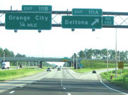
|Signed as exits 111A (Deltona) and 111B (Orange City)
|-
|Orange City
|113.783
|114
|
|
|-
|rowspan=2|Lake Helen
|115.898
|116
|
|
|-
|118.456
|118
|
|
|-
|rowspan=3|Daytona Beach
| style="background:#fdd;"|129.131
| style="background:#fdd;"|129
| style="background:#fdd;"|
| style="background:#fdd;"|Eastbound exit and westbound entrance
|-
|131.987
|132
|
|Signed as exits 132A (south) and 132B (north)
|-
|
|
|
|Continuation beyond I-95
|-
Florida
Florida is a state in the southeastern United States, located on the nation's Atlantic and Gulf coasts. It is bordered to the west by the Gulf of Mexico, to the north by Alabama and Georgia and to the east by the Atlantic Ocean. With a population of 18,801,310 as measured by the 2010 census, it...
, United States
United States
The United States of America is a federal constitutional republic comprising fifty states and a federal district...
. It goes from Interstate 275
Interstate 275 (Florida)
Interstate 275 in Florida serves the Tampa Bay metropolitan area, measuring 60.696 miles in length. The southern terminus is I-75 near Palmetto, just five miles east of the Sunshine Skyway Bridge, a toll bridge crossing Tampa Bay. The highway passes through St...
in Tampa, Florida
Tampa, Florida
Tampa is a city in the U.S. state of Florida. It serves as the county seat for Hillsborough County. Tampa is located on the west coast of Florida. The population of Tampa in 2010 was 335,709....
(27.965°N 82.453°W) to Interstate 95
Interstate 95 in Florida
Interstate 95 is the main Interstate Highway on the east coast of the United States; it serves the Atlantic coast of Florida. It begins at a partial interchange with U.S. Highway 1 just south of downtown Miami, and heads north past Daytona Beach and Jacksonville to the Georgia state line at the St...
at Daytona Beach, Florida
Daytona Beach, Florida
Daytona Beach is a city in Volusia County, Florida, USA. According to 2008 U.S. Census Bureau estimates, the city has a population of 64,211. Daytona Beach is a principal city of the Deltona – Daytona Beach – Ormond Beach, Florida Metropolitan Statistical Area, which the census bureau estimated had...
(29.155°N 81.076°W). It also has the Florida Department of Transportation
Florida Department of Transportation
The Florida Department of Transportation is a decentralized agency charged with the establishment, maintenance, and regulation of public transportation in the state of Florida. The department was formed in 1969. It absorbed the powers of the Florida State Road Department...
designation of State Road 400, but only a small portion of the route is signed at the east end. I-4 is currently the lowest-numbered Interstate Highway within the contiguous 48 U.S. state
U.S. state
A U.S. state is any one of the 50 federated states of the United States of America that share sovereignty with the federal government. Because of this shared sovereignty, an American is a citizen both of the federal entity and of his or her state of domicile. Four states use the official title of...
s. The area that surrounds I-4 is often referred to as the I-4 Corridor.
Route description
I-4 maintains a diagonal, northeast–southwest route for much of its length, although it is signed east–west. The 132 miles (212.4 km) route begins with an interchange with I-275Interstate 275 (Florida)
Interstate 275 in Florida serves the Tampa Bay metropolitan area, measuring 60.696 miles in length. The southern terminus is I-75 near Palmetto, just five miles east of the Sunshine Skyway Bridge, a toll bridge crossing Tampa Bay. The highway passes through St...
in Tampa
Tâmpa
Tâmpa may refer to several villages in Romania:* Tâmpa, a village in Băcia Commune, Hunedoara County* Tâmpa, a village in Miercurea Nirajului, Mureş County* Tâmpa, a mountain in Braşov city...
and continues east toward I-75.
After passing through the eastern suburbs of Hillsborough County
Hillsborough County, Florida
As of the census of 2000, there were 998,948 people, 391,357 households, and 255,164 families residing in the county. The population density was 951 people per square mile . There were 425,962 housing units at an average density of 405 per square mile...
, it crosses into Polk County
Polk County, Florida
Polk County is located in central Florida between the Tampa Bay and Greater Orlando metropolitan areas. The county was established by the state government in 1861 on the eve of the American Civil War and named after former United States president James K. Polk. The county seat is Bartow and its...
, entering the Lakeland
Lakeland, Florida
Lakeland is a city in Polk County, Florida, United States, located approximately midway between Tampa and Orlando along Interstate 4. According to the 2008 U.S. Census Bureau estimate, the city had a population of 94,406...
area, intersecting with the Polk Parkway twice before entering Polk City
Polk City, Florida
Polk City is a city in Polk County, Florida, United States. The population was 1,516 at the 2000 census. As of 2004, the population recorded by the U.S. Census Bureau is 1,515. It is part of the Lakeland–Winter Haven Metropolitan Statistical Area...
.
At this point, the interstate starts a turn toward the northeast where it intersects with the Orlando
Orlando, Florida
Orlando is a city in the central region of the U.S. state of Florida. It is the county seat of Orange County, and the center of the Greater Orlando metropolitan area. According to the 2010 US Census, the city had a population of 238,300, making Orlando the 79th largest city in the United States...
area cutting the city through at a diagonal direction going northeast/southwest. The route provides access to all of Orlando's theme parks including Disney World and Universal Studios
Universal Studios
Universal Pictures , a subsidiary of NBCUniversal, is one of the six major movie studios....
, as well as nearly all of Orlando's toll road
Toll road
A toll road is a privately or publicly built road for which a driver pays a toll for use. Structures for which tolls are charged include toll bridges and toll tunnels. Non-toll roads are financed using other sources of revenue, most typically fuel tax or general tax funds...
s, including Florida's Turnpike
Florida's Turnpike
Florida's Turnpike , designated as the Ronald Reagan Turnpike, and originally known as the Sunshine State Parkway is a north–south toll road that runs through 11 counties in the Florida peninsula, from U.S...
. Throughout most of Orange County
Orange County, Florida
Orange County is a county located in the U.S. state of Florida and is part of the Orlando-Kissimmee-Sanford Metropolitan Statistical Area . As of 2010 U.S. Census, the county had a population of 1,145,956....
and Seminole County
Seminole County, Florida
Seminole County is a county in the U.S. state of Florida. Located between Orlando to the south and Deland and Daytona Beach to the north, it is part of the Greater Orlando metropolitan area. Its county seat and largest city is Sanford...
, I-4 travels in a roughly north–south direction. This causes endless trepidations for outsiders, since the exits are named according to I-4's generally west–east orientation.
Interstate 95 in Florida
Interstate 95 is the main Interstate Highway on the east coast of the United States; it serves the Atlantic coast of Florida. It begins at a partial interchange with U.S. Highway 1 just south of downtown Miami, and heads north past Daytona Beach and Jacksonville to the Georgia state line at the St...
. At an interchange with I-95 in Daytona Beach, I-4 terminates; however, SR 400 continues eastward into Daytona Beach.
SR 400, unsigned while concurrent with I-4, becomes signed east of I-95. The road extends for three miles (5 km) from the northeast terminus of I-4, on the south side of Daytona International Speedway
Daytona International Speedway
Daytona International Speedway is a race track in Daytona Beach, Florida, United States. Since opening in 1959, it has been the home of the Daytona 500, one of the most prestigious races in NASCAR. In addition to NASCAR, the track also hosts races of ARCA, AMA Superbike, Grand-Am and Motocross...
and Daytona Beach International Airport
Daytona Beach International Airport
Daytona Beach International Airport is a public county-owned airport located three miles southwest of the central business district of Daytona Beach, adjacent to the Daytona International Speedway, in Volusia County, Florida, United States. The airport has 3 runways, a six-gate domestic terminal,...
, to an intersection with U.S. Route 1
U.S. Route 1 in Florida
U.S. Route 1 in Florida runs along the state's east coast from Key West to its crossing of the St. Marys River into Georgia north of Boulogne, and south of Folkston. US 1 was designated through Florida when the U.S. Highway System was established in 1926.US 1 runs in the state of Florida, and...
(SR 5) in Daytona Beach
Daytona Beach, Florida
Daytona Beach is a city in Volusia County, Florida, USA. According to 2008 U.S. Census Bureau estimates, the city has a population of 64,211. Daytona Beach is a principal city of the Deltona – Daytona Beach – Ormond Beach, Florida Metropolitan Statistical Area, which the census bureau estimated had...
. Named Beville Road, it runs along the boundary between the cities of Daytona Beach
Daytona Beach, Florida
Daytona Beach is a city in Volusia County, Florida, USA. According to 2008 U.S. Census Bureau estimates, the city has a population of 64,211. Daytona Beach is a principal city of the Deltona – Daytona Beach – Ormond Beach, Florida Metropolitan Statistical Area, which the census bureau estimated had...
and South Daytona
South Daytona, Florida
South Daytona is a city in Volusia County, Florida, United States. The population was 13,177 at the 2000 census. As of 2004, the population recorded by the U.S...
. The sections of Beville Road (the local name of SR 400), where it runs through the city, is classified a "Scenic Thoroughfare" by the City of Daytona Beach.
History
I-4 was one of the first Interstate Highways to be constructed in Florida, with the first section opening between Plant City and Lakeland in 1959. By early 1960, the Howard Frankland BridgeHoward Frankland Bridge
The W. Howard Frankland Bridge is the central bridge spanning Old Tampa Bay from St. Petersburg, Florida to Tampa, Florida. It is one of three bridges connecting Hillsborough County and Pinellas County; the others being Gandy Bridge and Courtney Campbell Causeway...
was opened to traffic, as well as the segment from the Hillsborough Avenue/ US 301 junction in Tampa to Plant City. The stretch from Lake Monroe to Lake Helen, including the original St. Johns River Bridge
St. Johns River Veterans Memorial Bridge
The original St. Johns River Bridge was a four-lane concrete-and-steel causeway bridge constructed over the St. Johns River at the west outlet of Lake Monroe. It is a part of Interstate 4, and spans the border between Seminole and Volusia Counties in Florida, United States...
also opened during that period. The segment from Lakeland to Orlando was complete by 1962. By the mid 1960s, several segments were already complete, including Malfunction Junction
Malfunction Junction
Malfunction Junction is a derisive nickname given by motorists to a confusing, dangerous, or otherwise problematic interchange.-Alabama:*Interstates in Birmingham. This interchange is the busiest in Alabama, and has been the site of many accidents, including roadway punctures and two fiery...
in Tampa and parts of I-4 through Orlando. The original western terminus was set in South Pasadena
South Pasadena, Florida
South Pasadena is a city located in southern Pinellas County, Florida, near St. Petersburg. The population was 5,778 at the 2000 census. As of 2004, the population estimated by the U.S. Census Bureau is 5,745 .-Geography:...
in the late 1960s, but this plan was rejected due to local opposition. As a result, I-4 went southwest only to 9th St N in St. Petersburg.
The entire Interstate Highway was completed by the late 1960s, however, the western terminus was truncated to Malfunction Junction
Malfunction Junction
Malfunction Junction is a derisive nickname given by motorists to a confusing, dangerous, or otherwise problematic interchange.-Alabama:*Interstates in Birmingham. This interchange is the busiest in Alabama, and has been the site of many accidents, including roadway punctures and two fiery...
in 1971 when I-75 was extended over the Frankland Bridge. Eventually, that stretch was again redesignated to become part of I-275
Interstate 275 (Florida)
Interstate 275 in Florida serves the Tampa Bay metropolitan area, measuring 60.696 miles in length. The southern terminus is I-75 near Palmetto, just five miles east of the Sunshine Skyway Bridge, a toll bridge crossing Tampa Bay. The highway passes through St...
.
In maps and atlases dating to the 1950s, 1960s, and 1970s, The Tampa/St. Petersburg section of Interstate 4/Interstate 275 was marked as the Tampa Expressway. The Orlando segment was marked as the Orlando Expressway. Both names have since faded from maps.
Although many post-1970 interchanges along I-4 were constructed before the recent widening projects, they were designed with I-4 expansion in mind. In other words, there is enough room available to widen I-4 to up to ten lanes without extensively modifying the interchanges. Some of these interchanges include the Interstate 75 stack (constructed in the 1980s) and several interchanges serving the Walt Disney World Resort
Walt Disney World Resort
Walt Disney World Resort , is the world's most-visited entertaimental resort. Located in Lake Buena Vista, Florida ; approximately southwest of Orlando, Florida, United States, the resort covers an area of and includes four theme parks, two water parks, 23 on-site themed resort hotels Walt...
(constructed in the late 1980s/early 1990s).
In 2002, I-4, along with most of Florida's interstates, switched over from a sequential exit numbering system to a mileage based exit numbering system.
In the 2004 U.S. presidential election, the I-4 corridor, a site of significant growth, was a focus of political activity within the swing state
Swing state
In United States presidential politics, a swing state is a state in which no single candidate or party has overwhelming support in securing that state's electoral college votes...
of Florida. Communities along the I-4 corridor were perceived by both major political parties as having higher proportions of undecided voters as compared to more Republican- or Democratic-leaning portions of the state. It played an equally key role in the 2008 U.S. presidential election, but whereas the corridor had voted heavily for Bush in 2004, which helped Bush win the state, in 2008 it swung behind Democratic candidate Obama, helping Obama win Florida.
A section of I-4 between Daytona Beach and Orlando called the 'dead zone' is rumored to be haunted. In 2010, the ECFRPC using GIS technology performed an analysis to determine if this identified zone had an increased fatality rate related to crashes. The analysis which compared this section of I-4 to several other dangerous I-4 sections found that while the dead zone area did not have the highest accident or fatality rate, it did identify that the percentage of fatality to accident was significantly higher in this location. In other words, while you are not more likely to be in accident in this section of I-4, if an accident occurs the chance of that accident containing a fatality is greatly increased.
Tampa area
The I-4/I-275 interchange (Malfunction JunctionMalfunction Junction
Malfunction Junction is a derisive nickname given by motorists to a confusing, dangerous, or otherwise problematic interchange.-Alabama:*Interstates in Birmingham. This interchange is the busiest in Alabama, and has been the site of many accidents, including roadway punctures and two fiery...
) was rebuilt from 2002 to 2006, and I-4 is under staged renovations to be widened from four to six lanes (with eight lanes in certain segments). Much of this work is complete, and all new travel lanes are now open. Eventually, I-4 will be widened again to a total of at least ten lanes (five in each direction). Studies for this project are already underway and construction should commence sometime in the 2010s. Completion of the project should be around 2020.
Malfunction Junction
Malfunction Junction is a derisive nickname given by motorists to a confusing, dangerous, or otherwise problematic interchange.-Alabama:*Interstates in Birmingham. This interchange is the busiest in Alabama, and has been the site of many accidents, including roadway punctures and two fiery...
and 50th St on Tuesday, August 8, 2006 at 5:30 am. The new alignment includes a right-lane ramp exit/entry at the 22nd St/21st St Interchange (The previous left-lane configuration was causing hazardous conditions to commuters since its opening in 2005). On Friday, August 11, 2006, a fourth lane opened on eastbound I-4 between the downtown junction and 50th St (led in by a newly opened third lane on the eastbound I-4 ramp from northbound I-275). And on Friday, August 18, the new westbound alignment, just west of 50th Street, opened. The newly opened lanes will improve flow throughout the interchange. The 50th St overpass however, will not be complete until late 2007. Also, the eastbound I-4 exit ramp to Columbus Drive/50th Street is situated to the left-hand side of the highway (as opposed to its former right-hand side exit). This exit shift went into effect in spring 2006 and is part of the new, permanent interstate configuration.
In Tampa, the exit to 40th Street (State Road 569) has been closed since late 2005 due to the ongoing reconstruction of I-4; it will not reopen due to a proposed connector highway with the Lee Roy Selmon Expressway.
The interchange with what is today Interstate 75 was constructed in the early 1980s.
Orlando area
As Orlando grew in the 1970s and 1980s, traffic became a growing concern, especially after the construction of the original interchange with the East–West Expressway in 1973, which proved to become a principal bottleneck. The term "highway hostages" was coined in the 1980s to describe people stuck in long commutes to and from Orlando on I-4.Kissimmee, Florida
Kissimmee is a city in Osceola County, Florida, United States. As of the 2010 census, the population was 59,682. It is the county seat of Osceola County...
were constructed/upgraded to accommodate increasing traffic going to and from Walt Disney World. However, I-4's main lanes were not widened in the process. Around the same time, the Southern Connector
State Road 417 (Florida)
State Road 417 , also known as the Central Florida GreeneWay, Southern Connector and Seminole Expressway , is a tolled freeway forming the eastern beltway around the city of Orlando, Florida, United States. It is owned and maintained by the Orlando-Orange County Expressway Authority and Florida's...
was extended to I-4.
The St. Johns River Veterans Memorial Bridge
St. Johns River Veterans Memorial Bridge
The original St. Johns River Bridge was a four-lane concrete-and-steel causeway bridge constructed over the St. Johns River at the west outlet of Lake Monroe. It is a part of Interstate 4, and spans the border between Seminole and Volusia Counties in Florida, United States...
, a two-span six-lane replacement to the original four-lane bridge over the St. Johns River
St. Johns River
The St. Johns River is the longest river in the U.S. state of Florida and its most significant for commercial and recreational use. At long, it winds through or borders twelve counties, three of which are the state's largest. The drop in elevation from the headwaters to the mouth is less than ;...
northeast of Orlando, was completed in 2004.
During the early 2000s, tolled
Toll road
A toll road is a privately or publicly built road for which a driver pays a toll for use. Structures for which tolls are charged include toll bridges and toll tunnels. Non-toll roads are financed using other sources of revenue, most typically fuel tax or general tax funds...
express lanes were being planned in the Orlando area as a traffic congestion relief technique for rush hour
Rush hour
A rush hour or peak hour is a part of the day during which traffic congestion on roads and crowding on public transport is at its highest. Normally, this happens twice a day—once in the morning and once in the evening, the times during when the most people commute...
commuters. The name for them was to be Xpress 400, numbered after the state road designation for I-4, SR 400. The express lanes were slated to extend from Universal Orlando, east to SR 434 in Longwood
Longwood, Florida
Longwood is a city in Seminole County, Florida, USA. The population was 13,745 at the 2000 census. As of 2006, the population recorded by the U.S. Census Bureau is 13,491. It is part of the Orlando–Kissimmee-Sanford Metropolitan Statistical Area....
, and tolls were to be collected electronically
Electronic toll collection
Electronic toll collection , an adaptation of military "identification friend or foe" technology, aims to eliminate the delay on toll roads by collecting tolls electronically. It is thus a technological implementation of a road pricing concept...
via transponders like SunPass
SunPass
SunPass is an electronic toll collection system in use by the State of Florida and was originally created by the Florida Department of Transportation's Florida's Turnpike...
and Orlando-Orange County Expressway Authority
Orlando-Orange County Expressway Authority
The Orlando-Orange County Expressway Authority is an expressway authority responsible for construction, maintenance and operation of toll roads in Orange County, Florida, United States, which includes the city of Orlando. It was founded in 1963 for the purpose of building the Bee Line Expressway,...
's E-Pass, with prices dependent on the congestion of the eight main lanes. However, the project was effectively banned by the passage of the SAFETEA-LU
Safe, Accountable, Flexible, Efficient Transportation Equity Act: A Legacy for Users
The Safe, Accountable, Flexible, Efficient Transportation Equity Act: A Legacy for Users is a funding and authorization bill that governs United States federal surface transportation spending. It was signed into law by President George W. Bush on August 10, 2005, and expired as of September 30, 2009...
Federal transportation bill in 2005, introduced by U.S. Representative
United States House of Representatives
The United States House of Representatives is one of the two Houses of the United States Congress, the bicameral legislature which also includes the Senate.The composition and powers of the House are established in Article One of the Constitution...
John Mica
John Mica
John L. Mica is the U.S. Representative for , serving since 1993. He is a member of the Republican Party. He is the chairman of the House Transportation and Infrastructure Committee, starting January 3, 2011....
. The plan for tolled express lanes, however, is still in the long term plans for I-4.
The eastbound exit to Robinson Street (State Road 526) permanently closed at 11PM on April 25, 2006, to make way for construction of the new eastbound onramp from State Road 408
State Road 408 (Florida)
State Road 408 , also known as the Spessard L. Holland East-West Expressway, is a tolled expressway running east–west through Orlando, Florida, United States...
. The westbound offramp to Gore Street was permanently closed in the same project on 2008-02-11.
The new overpass
Overpass
An overpass is a bridge, road, railway or similar structure that crosses over another road or railway...
from I-4 west to John Young Parkway
John Young Parkway
State Road 423, known for most of its length as John Young Parkway, and Lee Road east of Orange Blossom Trail, is a four- and six-lane surface road in the U.S. state of Florida. SR 423 is completely inside Orlando, Florida and runs from SR 408 north to U.S...
(County Road 423) opened the morning of April 27, 2006.
2008 Pileup
On January 9, 2008, 70 vehicles were involved in a large pileup on I-4 near Polk CityPolk City, Florida
Polk City is a city in Polk County, Florida, United States. The population was 1,516 at the 2000 census. As of 2004, the population recorded by the U.S. Census Bureau is 1,515. It is part of the Lakeland–Winter Haven Metropolitan Statistical Area...
. The pileup was caused by an unexpected thick morning fog that was mixed with a scheduled—and approved—environmental burn by the Florida Wildlife Commission. The fog drifted across I-4, mixing with the smoke, reducing visibility to near-zero conditions. Four people were killed, and 38 were injured. The section of I-4 did not re-open until 6:30 pm the next day, January 10.
Future
Interim improvements to the interchange at State Road 408 were completed at the end of 2008. The rest of the SR 408 improvements are scheduled for the next decade. Intersections at US 192 and I-275 were completed in 2007. The remaining four-lane segment, from SR 44 to I-95, will eventually be widened to six lanes, with construction anticipated to begin in 2012.Planning is underway for "ultimate" improvements to Interstate 4 through Orlando from SR 435 (exit 75) east to SR 434 (exit 94). These plans involve adding express lanes to the highway, and the reconstruction of several major interchanges. Construction is scheduled to begin in 2014.
Exit list
{|class=wikitable|-
!County
!Location
!Mile
!Exit
Exit number
An exit number is a number assigned to a road junction, usually an exit from a freeway. It is usually marked on the same sign as the destinations of the exit, as well as a sign in the gore....
!Destinations
!Notes
|-
|rowspan=15|Hillsborough
Hillsborough County, Florida
As of the census of 2000, there were 998,948 people, 391,357 households, and 255,164 families residing in the county. The population density was 951 people per square mile . There were 425,962 housing units at an average density of 405 per square mile...
|rowspan=6|Tampa
Tampa, Florida
Tampa is a city in the U.S. state of Florida. It serves as the county seat for Hillsborough County. Tampa is located on the west coast of Florida. The population of Tampa in 2010 was 335,709....
| style="background:#fdd;"|0.000
| style="background:#fdd;"|
| style="background:#fdd;"|, Tampa International Airport
Tampa International Airport
Tampa International Airport is a major public airport located six nautical miles west of the central business district of Tampa, in Hillsborough County, Florida, United States. This airport is publicly owned by Hillsborough County Aviation Authority...
| style="background:#fdd;"|Westbound exit and eastbound entrance
|-
|1.154
|1
|
|
|-
| style="background:#ffdead;"|
| style="background:#ffdead;"|2
| style="background:#ffdead;"|, Lee Roy Selmon Expressway
| style="background:#ffdead;"|Connector under construction as of 2011, scheduled to open in 2013
|-
|3.266
|3
|
|
|-
|4.706
|5
|
|
|- style="background:#fdd;"
||5.573
||6
||Orient Road
||Eastbound exit and westbound entrance
|-
|rowspan=2|Mango
Mango, Florida
Mango is an unincorporated census-designated place in Hillsborough County, Florida, United States. The population was 8,842 at the 2000 census.-Geography:Mango is located at ....
|6.683
|7
|
|
|-
|8.610
|9
|
|
|-
|
|10.142
|10
|
|
|-
|
|13.876
|14
|McIntosh Road
|
|-
|
|17.434
|17
|Branch Forbes Road
|
|-
|rowspan=3|Plant City
Plant City, Florida
Plant City is a city in Hillsborough County, Florida, in the United States, approximately midway between Brandon and Lakeland along Interstate 4. The population was 34,721 at the 2010 census....
|19.518
|19
|
|
|-
|21.280
|21
|
|
|-
|22.596
|22
|
|
|-
|
|25.563
|25
|County Line Road
|
|-
|rowspan=10|Polk
Polk County, Florida
Polk County is located in central Florida between the Tampa Bay and Greater Orlando metropolitan areas. The county was established by the state government in 1861 on the eve of the American Civil War and named after former United States president James K. Polk. The county seat is Bartow and its...
|rowspan=5|Lakeland
Lakeland, Florida
Lakeland is a city in Polk County, Florida, United States, located approximately midway between Tampa and Orlando along Interstate 4. According to the 2008 U.S. Census Bureau estimate, the city had a population of 94,406...
|26.530
|27
|
|
|-
|28.365
|28
|
|
|-
|30.675
|31
|
|
|-
|32.003
|32
|
|
|-
|33.440
|33
|
|
|-
|
|37.894
|38
|
|
|-
|rowspan=2|Polk City
Polk City, Florida
Polk City is a city in Polk County, Florida, United States. The population was 1,516 at the 2000 census. As of 2004, the population recorded by the U.S. Census Bureau is 1,515. It is part of the Lakeland–Winter Haven Metropolitan Statistical Area...
|41.223
|41
|
|
|-
|43.981
|44
|
|
|-
|
|47.982
|48
|
|
|-
|Davenport
Davenport, Florida
Davenport is a city in Polk County, Florida, United States. The population was 1,925 at the 2000 census. As of 2004, the population estimated by the U.S. Census Bureau is 1,994. While the city of Davenport itself is very small, the area north of the city close to Interstate 4 and US 27 is...
|54.733
|55
|
|
|-
|rowspan=5|Osceola
Osceola County, Florida
Osceola County is a county located in the U.S. state of Florida. As of 2000, the population was 172,493. The U.S. Census Bureau 2006 estimate for the county is 244,045, making it the 17th fastest-growing county in the United States. Its county seat is Kissimmee.- History :Osceola County was...
|
|57.723
|58
|
|
|-
|
|59.663
|60
|
|
|-
|rowspan=2|Celebration
Celebration, Florida
Celebration is a census-designated place and a master-planned community in Osceola County, Florida, United States, located near Walt Disney World Resort and originally developed by The Walt Disney Company...
|61.781
|62
|, Disney World, International Airport
|
|-
|64.165
|64
|, Magic Kingdom
Magic Kingdom
Magic Kingdom Park is one of four theme parks at the Walt Disney World Resort located near Orlando, Florida. The first park built at the resort, Magic Kingdom opened Oct. 1, 1971. Designed and built by WED Enterprises, the park's layout and attractions are similar to Disneyland in Anaheim, California...
, Disney's Hollywood Studios
Disney's Hollywood Studios
Disney's Hollywood Studios is a theme park at the Walt Disney World Resort. Spanning 135 acres in size, its theme is show business, drawing inspiration from the heyday of Hollywood in the 1930s and 1940s...
|
|-
|
|65.322
|65
|Osceola Parkway
Osceola Parkway
The Osceola Parkway, signed as County Road 522 since around 2003 , is a long, partially-tolled arterial road extending east-west across the northern boundary of Osceola County, Florida, USA roughly paralleling the border with Orange County...
– Animal Kingdom, Disney's Wide World of Sports Complex
Disney's Wide World of Sports Complex
ESPN Wide World of Sports Complex is a athletic complex located in the Walt Disney World Resort. The complex includes 9 venues and hosts numerous amateur and professional sporting events throughout the year....
|
|-
|rowspan=23|Orange
Orange County, Florida
Orange County is a county located in the U.S. state of Florida and is part of the Orlando-Kissimmee-Sanford Metropolitan Statistical Area . As of 2010 U.S. Census, the county had a population of 1,145,956....
|rowspan=2|Lake Buena Vista
Lake Buena Vista, Florida
Lake Buena Vista is a city in Orange County, Florida, United States. It is mostly known for being home to the Walt Disney World Resort. It is one of two Florida municipalities controlled by The Walt Disney Company, the other being Bay Lake....
|66.565
|67
| – Epcot
Epcot
Epcot is a theme park in the Walt Disney World Resort, located near Orlando, Florida. The park is dedicated to the celebration of human achievement, namely international culture and technological innovation. The second park built at the resort, it opened on October 1, 1982 and was initially named...
, Downtown Disney
Downtown Disney (Florida)
Downtown Disney is an outdoor shopping, dining, and entertainment complex located at the Walt Disney World Resort in Lake Buena Vista, Florida. Downtown Disney is open to the public, requires no admission fee, and offers complimentary parking and transportation to all Disney-operated Walt Disney...
|
|-
|68.107
|68
|
|
|-
|
| style="background:#fdd;"|70.983
| style="background:#fdd;"|71
| style="background:#fdd;"|Central Florida Parkway – Sea World
| style="background:#fdd;"|Eastbound exit and westbound entrance
|-
|rowspan=16|Orlando
Orlando, Florida
Orlando is a city in the central region of the U.S. state of Florida. It is the county seat of Orange County, and the center of the Greater Orlando metropolitan area. According to the 2010 US Census, the city had a population of 238,300, making Orlando the 79th largest city in the United States...
|71.744
|72
| – International Airport, Cape Canaveral
Cape Canaveral
Cape Canaveral, from the Spanish Cabo Cañaveral, is a headland in Brevard County, Florida, United States, near the center of the state's Atlantic coast. Known as Cape Kennedy from 1963 to 1973, it lies east of Merritt Island, separated from it by the Banana River.It is part of a region known as the...
|
|-
|73.732
|74A
|
|
|-
| style="background:#fdd;"|75.246
| style="background:#fdd;"|74B
| style="background:#fdd;"|Universal
| style="background:#fdd;"|Westbound exit and entrance
|-
|75.246
|75
| – Universal Boulevard
|Signed as exits 75A (south) and 75B (north)
|-
|76.359
|77
|
|
|-
|77.760
|78
|Conroy Road – The Mall at Millenia
The Mall at Millenia
The Mall at Millenia is an upscale contemporary indoor shopping mall located in Orlando, Florida just off of Interstate 4 at Conroy Road near the northern end of International Drive. Opened in 2002, it has over 150 stores, and is anchored by Macy's, Bloomingdale's, and Neiman Marcus...
|
|-
|79.147
|79
|
|
|-
|80.474
|80
|
|Signed as exits 80A (south/west) and 80B (north/east) southbound
|- style="background:#fdd;"
||81.004
||81A
||Michigan Street
||Westbound exit and eastbound entrance
|-
|81.469
|81
|Kaley Avenue
|Signed as exits 81B (east) and 81C (west) westbound
|-
|82.116
|82A
|
|
|- style="background:#fdd;"
||82.646
||82B
||Anderson Street – Amway Center, Downtown Orlando
Downtown Orlando
Downtown Orlando is the historic core and central business district of Orlando, Florida, United States. It is bordered by East Marks St in the north, Mills Ave in the east, Orange Blossom Trail in the west, and Kaley Ave in the south...
||Westbound exit and eastbound entrance
|-
|82.636
|82B
|South Street – Amway Center, Downtown Orlando
Downtown Orlando
Downtown Orlando is the historic core and central business district of Orlando, Florida, United States. It is bordered by East Marks St in the north, Mills Ave in the east, Orange Blossom Trail in the west, and Kaley Ave in the south...
|Signed as exit 83 westbound
|-
|83.792
|83A
|
|
|-
|84.279
|84
|Ivanhoe Boulevard
|
|-
|85.135
|85
|Princeton Street
|
|-
|rowspan=3|Winter Park
Winter Park, Florida
Winter Park is a suburban city in Orange County, Florida, United States. The population was 24,090 at the 2000 census. According to the U.S. Census Bureau's 2006 estimates, the city had a population of 28,083. It is part of the Orlando–Kissimmee Metropolitan Statistical Area...
|85.890
|86
|Par Street
|Eastbound exit and westbound entrance
|-
|86.789
|87
|
|
|-
|87.767
|88
|
|
|-
|Maitland
Maitland, Florida
Maitland is a suburban city in Orange County, Florida, United States, part of the Greater Metro Orlando area. The population was 12,019 at the 2000 census. As of 2006, the population recorded by the U.S. Census Bureau is 14,172...
|89.491
|90
|
|Signed as exits 90A (east) and 90B (west) eastbound
|-
|rowspan=7|Seminole
Seminole County, Florida
Seminole County is a county in the U.S. state of Florida. Located between Orlando to the south and Deland and Daytona Beach to the north, it is part of the Greater Orlando metropolitan area. Its county seat and largest city is Sanford...
|rowspan=2|Altamonte Springs
Altamonte Springs, Florida
Altamonte Springs is a city in Seminole county in the U.S. state of Florida, which had a population of 41,496 at the 2010 census. Located primarily in Seminole County, the city is in the northern suburbs of the Orlando–Kissimmee-Sanford Metropolitan Statistical Area, which the United States...
|91.631
|92
|
|
|-
|93.613
|94
|
|
|-
|Lake Mary
Lake Mary, Florida
Lake Mary is a city in Seminole County, Florida, United States. The population was 11,456 at the 2000 census. As of 2009, the population recorded by the U.S. Census Bureau is 15,230...
|98.400
|98
|Lake Mary Boulevard – Lake Mary
Lake Mary, Florida
Lake Mary is a city in Seminole County, Florida, United States. The population was 11,456 at the 2000 census. As of 2009, the population recorded by the U.S. Census Bureau is 15,230...
, Heathrow
Heathrow, Florida
Heathrow is a census-designated place and an unincorporated suburban community in Seminole County, Florida, United States. Heathrow is located on the I-4 Corridor in Central Florida, 19 miles Northeast of Orlando and 38 miles Southwest of Daytona Beach...
|
|-
|rowspan=3|Sanford
Sanford, Florida
Sanford is a city in, and the county seat of, Seminole County, Florida, United States. The population was 38,291 at the 2000 census. As of 2009, the population recorded by the U.S. Census Bureau was 50,998...
|100.628
|101A
|
|
|-
|101.366
|101B
| – International Airport
|
|-
|102.505
|101C
|
|
|-
|
|103.997
|104
|
|
|-
|rowspan=8|Volusia
Volusia County, Florida
Volusia County is a county located in the state of Florida. The U.S. Census Bureau 2010 official county's population was 494,593 . Its county seat is DeLand, and its most populous city is currently Deltona....
|rowspan=2|Deltona
Deltona, Florida
Deltona is a city in the central region of the U.S. state of Florida and is the largest city in Volusia County. It is located east of DeBary and north of Lake Monroe. It is the twenty-ninth largest city in Florida, with a 2010 Census population of 85,182...
|107.821
|108
|
|
|-
|110.636
|111
|
|Signed as exits 111A (Deltona) and 111B (Orange City)
|-
|Orange City
Orange City, Florida
Orange City is a city located in Volusia County, Florida. In the 2000 census the city had a total population of 6,604. In 2004 the population recorded by the U.S. Census Bureau was 7,172.-Geography:Orange City is located at ....
|113.783
|114
|
|
|-
|rowspan=2|Lake Helen
Lake Helen, Florida
For the high-altitude lake in Lassen Volcanic National Park, see Lake Helen Lake Helen is a city in Volusia County, Florida, United States. The population was 2,743 at the 2000 census. As of 2004, the population recorded by the U.S...
|115.898
|116
|
|
|-
|118.456
|118
|
|
|-
|rowspan=3|Daytona Beach
Daytona Beach, Florida
Daytona Beach is a city in Volusia County, Florida, USA. According to 2008 U.S. Census Bureau estimates, the city has a population of 64,211. Daytona Beach is a principal city of the Deltona – Daytona Beach – Ormond Beach, Florida Metropolitan Statistical Area, which the census bureau estimated had...
| style="background:#fdd;"|129.131
| style="background:#fdd;"|129
| style="background:#fdd;"|
| style="background:#fdd;"|Eastbound exit and westbound entrance
|-
|131.987
|132
|
|Signed as exits 132A (south) and 132B (north)
|-
|
|
|
|Continuation beyond I-95
|-
External links
- Tampa Bay Interstates (Tampa-area reconstruction)
- I4Polk.com (Lakeland-area reconstruction)
- Trans4mation (Orlando-area reconstruction)