
Craven County, North Carolina
Encyclopedia
Craven County is a county located in the U.S. state
of North Carolina
. The estimated population in 2006 was 94,875.http://quickfacts.census.gov/qfd/states/37/37049.html Its county seat
is New Bern
.
Craven County is part of the New Bern, North Carolina, Micropolitan Statistical Area
.
in 1712.
, the county has a total area of 774 square miles (2,004.7 km²), of which 708 square miles (1,833.7 km²) is land and 66 square miles (170.9 km²) (8.49%) is water.
.
of 2000, there were 91,436 people, 34,582 households, and 25,071 families residing in the county. The population density
was 129 people per square mile (50/km²). There were 38,150 housing units at an average density of 54 per square mile (21/km²). The racial makeup of the county was 69.94% White
, 25.12% Black
or African American
, 0.42% Native American
, 0.99% Asian
, 0.06% Pacific Islander
, 1.78% from other races
, and 1.68% from two or more races. 4.02% of the population were Hispanic
or Latino
of any race.
There were 34,582 households out of which 33.30% had children under the age of 18 living with them, 56.80% were married couples
living together, 12.50% had a female householder with no husband present, and 27.50% were non-families. 23.40% of all households were made up of individuals and 8.90% had someone living alone who was 65 years of age or older. The average household size was 2.50 and the average family size was 2.93.
In the county the population was spread out with 24.60% under the age of 18, 12.80% from 18 to 24, 27.90% from 25 to 44, 21.20% from 45 to 64, and 13.40% who were 65 years of age or older. The median age was 34 years. For every 100 females there were 101.90 males. For every 100 females age 18 and over, there were 101.50 males.
The median income for a household in the county was $35,966, and the median income for a family was $42,574. Males had a median income of $28,163 versus $21,412 for females. The per capita income
for the county was $18,423. About 9.90% of families and 13.10% of the population were below the poverty line, including 18.50% of those under age 18 and 11.00% of those age 65 or over.
U.S. state
A U.S. state is any one of the 50 federated states of the United States of America that share sovereignty with the federal government. Because of this shared sovereignty, an American is a citizen both of the federal entity and of his or her state of domicile. Four states use the official title of...
of North Carolina
North Carolina
North Carolina is a state located in the southeastern United States. The state borders South Carolina and Georgia to the south, Tennessee to the west and Virginia to the north. North Carolina contains 100 counties. Its capital is Raleigh, and its largest city is Charlotte...
. The estimated population in 2006 was 94,875.http://quickfacts.census.gov/qfd/states/37/37049.html Its county seat
County seat
A county seat is an administrative center, or seat of government, for a county or civil parish. The term is primarily used in the United States....
is New Bern
New Bern, North Carolina
New Bern is a city in Craven County, North Carolina with a population of 29,524 as of the 2010 census.. It is located at the confluence of the Trent and the Neuse rivers...
.
Craven County is part of the New Bern, North Carolina, Micropolitan Statistical Area
New Bern micropolitan area
The New Bern Micropolitan Statistical Area, as defined by the United States Census Bureau, is an area consisting of three counties in the Inner Banks region of eastern North Carolina, anchored by the city of New Bern....
.
History
Craven County was named for William, Earl of Craven, who lived from 1606-1697. The county was created from the now-extinct Bath CountyBath County, North Carolina
Bath County is an extinct county formerly located in the state of North Carolina. The county was established in 1696 and was abolished in 1739. The town of Bath was a stopping place of Edward Teach, better known as the pirate Blackbeard...
in 1712.
Geography
According to the U.S. Census BureauUnited States Census Bureau
The United States Census Bureau is the government agency that is responsible for the United States Census. It also gathers other national demographic and economic data...
, the county has a total area of 774 square miles (2,004.7 km²), of which 708 square miles (1,833.7 km²) is land and 66 square miles (170.9 km²) (8.49%) is water.
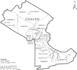
Adjacent counties
- Beaufort CountyBeaufort County, North Carolina- Law and government :Beaufort County is a member of the Mid-East Commission regional council of governments.Beaufort County is one of the proposed sites for a Navy outlying landing field. This practice airfield would allow pilots to simulate landings on an aircraft carrier...
(northeast) - Pamlico CountyPamlico County, North Carolina-Demographics:As of the census of 2000, there were 12,934 people, 5,178 households, and 3,717 families residing in the county. The population density was 38 people per square mile . There were 6,781 housing units at an average density of 20 per square mile...
(east) - Carteret CountyCarteret County, North CarolinaCarteret County is a county located in the U.S. state of North Carolina. As of 2010, the population was 66,469. Its county seat is Beaufort. Most of the county is part of the Crystal Coast....
(southeast) - Jones CountyJones County, North Carolina-Demographics:As of the census of 2000, there were 10,381 people, 4,061 households, and 2,936 families residing in the county. The population density was 22 people per square mile . There were 4,679 housing units at an average density of 10 per square mile...
(southwest) - Lenoir CountyLenoir County, North Carolina-Demographics:As of 2005, there were 57,961 people, 23,862 households, and 16,178 families residing in the county. The population density was 149.2 people per square mile . There were 27,940 housing units at an average density of 68 per square mile...
(west) - Pitt CountyPitt County, North Carolina-Demographics:As of the census of 2000, there were 133,798 people, 52,539 households, and 32,258 families residing in the county. The population density was 205 people per square mile . There were 58,408 housing units at an average density of 90 per square mile...
(northwest)
Law and government
Craven County is a member of the regional Eastern Carolina Council of GovernmentsEastern Carolina Council of Governments
The Eastern Carolina Council of Governments is one of the 17 regional North Carolina Councils of Governments established by the North Carolina General Assembly for the purpose of regional planning and administration. Headquartered in New Bern, North Carolina, it serves Onslow, Duplin, Wayne,...
.
Demographics
As of the censusCensus
A census is the procedure of systematically acquiring and recording information about the members of a given population. It is a regularly occurring and official count of a particular population. The term is used mostly in connection with national population and housing censuses; other common...
of 2000, there were 91,436 people, 34,582 households, and 25,071 families residing in the county. The population density
Population density
Population density is a measurement of population per unit area or unit volume. It is frequently applied to living organisms, and particularly to humans...
was 129 people per square mile (50/km²). There were 38,150 housing units at an average density of 54 per square mile (21/km²). The racial makeup of the county was 69.94% White
Race (United States Census)
Race and ethnicity in the United States Census, as defined by the Federal Office of Management and Budget and the United States Census Bureau, are self-identification data items in which residents choose the race or races with which they most closely identify, and indicate whether or not they are...
, 25.12% Black
Race (United States Census)
Race and ethnicity in the United States Census, as defined by the Federal Office of Management and Budget and the United States Census Bureau, are self-identification data items in which residents choose the race or races with which they most closely identify, and indicate whether or not they are...
or African American
Race (United States Census)
Race and ethnicity in the United States Census, as defined by the Federal Office of Management and Budget and the United States Census Bureau, are self-identification data items in which residents choose the race or races with which they most closely identify, and indicate whether or not they are...
, 0.42% Native American
Race (United States Census)
Race and ethnicity in the United States Census, as defined by the Federal Office of Management and Budget and the United States Census Bureau, are self-identification data items in which residents choose the race or races with which they most closely identify, and indicate whether or not they are...
, 0.99% Asian
Race (United States Census)
Race and ethnicity in the United States Census, as defined by the Federal Office of Management and Budget and the United States Census Bureau, are self-identification data items in which residents choose the race or races with which they most closely identify, and indicate whether or not they are...
, 0.06% Pacific Islander
Race (United States Census)
Race and ethnicity in the United States Census, as defined by the Federal Office of Management and Budget and the United States Census Bureau, are self-identification data items in which residents choose the race or races with which they most closely identify, and indicate whether or not they are...
, 1.78% from other races
Race (United States Census)
Race and ethnicity in the United States Census, as defined by the Federal Office of Management and Budget and the United States Census Bureau, are self-identification data items in which residents choose the race or races with which they most closely identify, and indicate whether or not they are...
, and 1.68% from two or more races. 4.02% of the population were Hispanic
Race (United States Census)
Race and ethnicity in the United States Census, as defined by the Federal Office of Management and Budget and the United States Census Bureau, are self-identification data items in which residents choose the race or races with which they most closely identify, and indicate whether or not they are...
or Latino
Race (United States Census)
Race and ethnicity in the United States Census, as defined by the Federal Office of Management and Budget and the United States Census Bureau, are self-identification data items in which residents choose the race or races with which they most closely identify, and indicate whether or not they are...
of any race.
There were 34,582 households out of which 33.30% had children under the age of 18 living with them, 56.80% were married couples
Marriage
Marriage is a social union or legal contract between people that creates kinship. It is an institution in which interpersonal relationships, usually intimate and sexual, are acknowledged in a variety of ways, depending on the culture or subculture in which it is found...
living together, 12.50% had a female householder with no husband present, and 27.50% were non-families. 23.40% of all households were made up of individuals and 8.90% had someone living alone who was 65 years of age or older. The average household size was 2.50 and the average family size was 2.93.
In the county the population was spread out with 24.60% under the age of 18, 12.80% from 18 to 24, 27.90% from 25 to 44, 21.20% from 45 to 64, and 13.40% who were 65 years of age or older. The median age was 34 years. For every 100 females there were 101.90 males. For every 100 females age 18 and over, there were 101.50 males.
The median income for a household in the county was $35,966, and the median income for a family was $42,574. Males had a median income of $28,163 versus $21,412 for females. The per capita income
Per capita income
Per capita income or income per person is a measure of mean income within an economic aggregate, such as a country or city. It is calculated by taking a measure of all sources of income in the aggregate and dividing it by the total population...
for the county was $18,423. About 9.90% of families and 13.10% of the population were below the poverty line, including 18.50% of those under age 18 and 11.00% of those age 65 or over.
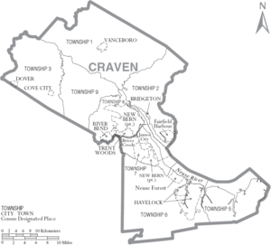
Cities and towns
- Brices CreekBrices Creek, North CarolinaBrices Creek is a census-designated place in Craven County, North Carolina, United States. The population was 2,060 at the 2000 census. It is part of the New Bern, North Carolina Micropolitan Statistical Area.-Geography:...
- BridgetonBridgeton, North CarolinaBridgeton is a town in Craven County, North Carolina, United States. The population was 328 at the 2000 census, and estimated to be 316 in 2006...
- Cove CityCove City, North CarolinaCove City is a town in Craven County, North Carolina, United States under the leadership of its mayor, Dred Charleton Mitchell, Jr. The population was 412 at the 2008 census...
- DoverDover, North CarolinaDover is a town in Craven County, North Carolina, United States. The population was 443 at the 2000 census, and estimated to be 418 in 2008. It is part of the New Bern, North Carolina Micropolitan Statistical Area.-Geography:...
- Fairfield HarbourFairfield Harbour, North CarolinaFairfield Harbour is a census-designated place in Craven County, North Carolina, United States. The population was 1,983 at the 2000 census...
- HavelockHavelock, North CarolinaHavelock is a city in Craven County, North Carolina, United States. The population was 22,442 at the 2000 census, and estimated to be 21,906 in 2006...
- James CityJames City, North CarolinaJames City is a census-designated place in Craven County, North Carolina, United States. The population was 5,420 at the 2000 census. It is part of the New Bern, North Carolina Micropolitan Statistical Area.-Geography:...
- Neuse ForestNeuse Forest, North CarolinaNeuse Forest is a census-designated place in Craven County, North Carolina, United States. The population was 1,426 at the 2000 census. It is part of the New Bern, North Carolina Micropolitan Statistical Area.-Geography:...
- New BernNew Bern, North CarolinaNew Bern is a city in Craven County, North Carolina with a population of 29,524 as of the 2010 census.. It is located at the confluence of the Trent and the Neuse rivers...
- River BendRiver Bend, North CarolinaRiver Bend is a town in Craven County, North Carolina, United States. The population was estimated at 3,069 in 2006. It is part of the New Bern, North Carolina Micropolitan Statistical Area.-Geography:River Bend is located at ....
- Trent WoodsTrent Woods, North CarolinaTrent Woods is a town in Craven County, North Carolina, United States. The population was estimated at 3,961 in 2005. It is part of the New Bern, North Carolina Micropolitan Statistical Area.-Geography:Trent Woods is located at ....
- VanceboroVanceboro, North CarolinaVanceboro is a town in Craven County, North Carolina, United States. The population was 849 at the 2008 census. Originally called Swift Creek, residents renamed the town for Zebulon B. Vance after he made a visit during his 1876 campaign for Governor...
- Harlowe
- Cherry Point
- Cherry Branch
- Adams Creek