

Transport in Sheffield
Encyclopedia
Sheffield
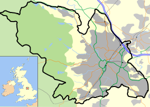
Sheffield is a city and metropolitan borough of South Yorkshire, England. Its name derives from the River Sheaf, which runs through the city. Historically a part of the West Riding of Yorkshire, and with some of its southern suburbs annexed from Derbyshire, the city has grown from its largely...
, England
England
England is a country that is part of the United Kingdom. It shares land borders with Scotland to the north and Wales to the west; the Irish Sea is to the north west, the Celtic Sea to the south west, with the North Sea to the east and the English Channel to the south separating it from continental...
is developed around the city's unusual topography and medieval street plan. Once an isolated town, the transport infrastructure changed dramatically in the 19th and 20th centuries. The city now has road and rail links with the rest of the country, and road, bus and trams for local transportation.
National and international travel

M1 motorway
The M1 is a north–south motorway in England primarily connecting London to Leeds, where it joins the A1 near Aberford. While the M1 is considered to be the first inter-urban motorway to be completed in the United Kingdom, the first road to be built to motorway standard in the country was the...
and M18 motorways. The M1 skirts the north-east of the city, linking Sheffield with London
London
London is the capital city of :England and the :United Kingdom, the largest metropolitan area in the United Kingdom, and the largest urban zone in the European Union by most measures. Located on the River Thames, London has been a major settlement for two millennia, its history going back to its...
to the south and Leeds
Leeds
Leeds is a city and metropolitan borough in West Yorkshire, England. In 2001 Leeds' main urban subdivision had a population of 443,247, while the entire city has a population of 798,800 , making it the 30th-most populous city in the European Union.Leeds is the cultural, financial and commercial...
to the north; the M18 branches from the M1 close to Sheffield, linking the city with Doncaster
Doncaster
Doncaster is a town in South Yorkshire, England, and the principal settlement of the Metropolitan Borough of Doncaster. The town is about from Sheffield and is popularly referred to as "Donny"...
, Robin Hood Doncaster Sheffield Airport and the Humber
Humber
The Humber is a large tidal estuary on the east coast of Northern England. It is formed at Trent Falls, Faxfleet, by the confluence of the tidal River Ouse and the tidal River Trent. From here to the North Sea, it forms part of the boundary between the East Riding of Yorkshire on the north bank...
ports. The Sheffield Parkway
Sheffield Parkway
The Sheffield Parkway is a major dual carriageway which runs between the City of Sheffield and junction 33 of the M1 in South Yorkshire, England. The 5.5 mile road was opened in 1974, and runs to the east of the City, connecting Park Square in the City centre with the inner ring road, outer ring...
connects the city centre with the motorways.
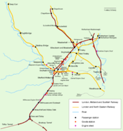
The topography of Sheffield makes it unsuitable for a large rail system. The Midland Main Line
Midland Main Line
The Midland Main Line is a major railway route in the United Kingdom, part of the British railway system.The present-day line links London St...
is the major railway through Sheffield, running in approximately a south-west to north-easterly direction. Other routes passing through the city include the Cross Country Route
Cross Country Route (MR)
The North-East/South-West route is the major British rail route running from South West England via Bristol, Birmingham, Sheffield and Leeds to North-East England. It facilitates some of the longest inter-city rail journeys in the UK such as Penzance to Aberdeen...
, the Penistone Line
Penistone Line
The Penistone Line is operated by Northern Rail in the West Yorkshire Metro/ Travel South Yorkshire area of northern England. It connects Huddersfield and Sheffield via Penistone and Barnsley, serving many rural communities...
, the Dearne Valley Line
Dearne Valley Line
The Dearne Valley Line is the name given to a railway line in the north of England running from York to Sheffield via Pontefract Baghill and Moorthorpe.-History:...
, the Hope Valley Line
Hope Valley Line
The Hope Valley Line is a railway line in England linking Sheffield with Manchester. It was completed in 1894.From Sheffield, trains head down the Midland Main Line to Dore, where the Hope Valley Line branches off to run through the Totley Tunnel .It emerges in the stunning scenery of the Hope...
, and the Hallam Line
Hallam Line
The Hallam Line is the name given to rail services operated by Northern Rail, in the West Yorkshire Metro/ Travel South Yorkshire area of northern England which connect Leeds and Sheffield via Barnsley. It is the slower of the two routes between Leeds and Sheffield, with faster services provided...
. The major station serving the city, Sheffield Station
Sheffield Midland station
Sheffield station, formerly Pond Street and later Sheffield Midland, is a railway station in Sheffield, England and is the busiest station in South Yorkshire...
, is on the south-eastern edge of the city centre. There is another major rail station at Meadowhall
Meadowhall Interchange
Meadowhall Interchange to the north of Sheffield, South Yorkshire, England is a railway station on the Midland Main Line, a Sheffield Supertram stop, and bus station. It is close to junction 34 on the M1, and serves Meadowhall Shopping Centre...
and four smaller suburban stations at Chapeltown
Chapeltown railway station
Chapeltown railway station, originally known as Chapeltown South, is a railway station in Chapeltown, a district of Sheffield, South Yorkshire, England...
, Darnall
Darnall railway station
Darnall railway station was built to serve Darnall, a community about from the centre of Sheffield, South Yorkshire, England and which later became a suburb of the city.-History:...
, Dore
Dore railway station
Dore and Totley railway station is a small, one platform railway halt near the Sheffield areas of Dore and Totley in South Yorkshire, England...
and Woodhouse
Woodhouse railway station
This station is in Woodhouse, Sheffield. It should not be confused with a station of similar name at Mansfield Woodhouse.Woodhouse railway station, formerly Woodhouse Junction, is a railway station serving the Woodhouse and Woodhouse Mill in Sheffield, South Yorkshire, England. The station is ...
. Passenger rail services through Sheffield are provided by East Midlands Trains
East Midlands Trains
East Midlands Trains is a British passenger train operating company. Based in Derby, it provides train services in the East Midlands, chiefly in the counties of Lincolnshire, South Yorkshire, Nottinghamshire, Leicestershire, Derbyshire and Northamptonshire, and between the East Midlands and London...
, CrossCountry
CrossCountry
CrossCountry is the brand name of XC Trains Ltd., a British train operating company owned by Arriva...
, TransPennine Express, and Northern Rail
Northern Rail
Northern Rail is a British train operating company that has operated local passenger services in Northern England since 2004. Northern Rail's owner, Serco-Abellio, is a consortium formed of Abellio and Serco, an international operator of public transport systems...
.
The closest international airport to Sheffield is Robin Hood Airport Doncaster Sheffield
Robin Hood Airport Doncaster Sheffield
Robin Hood Airport Doncaster Sheffield is an international airport located at the former RAF Finningley airbase at Finningley, in the Metropolitan Borough of Doncaster within South Yorkshire, England. The airport lies southeast of Doncaster and east of Sheffield.The airport is operated by Peel...
, which is located 18 miles from the city centre. The Airport opened on 28 April 2005 with the first flight to Palma de Mallorca
Palma de Mallorca
Palma is the major city and port on the island of Majorca and capital city of the autonomous community of the Balearic Islands in Spain. The names Ciutat de Mallorca and Ciutat were used before the War of the Spanish Succession and are still used by people in Majorca. However, the official name...
. It replaced Sheffield City Airport
Sheffield City Airport
Sheffield City Airport was a small airport located in Sheffield that is now closed. It was located in the Tinsley Park area of the city, near the M1 motorway and Sheffield Parkway, and opened in 1997...
, which opened in 1997 but is now closed to commercial airliners. Manchester Airport, Leeds Bradford International Airport
Leeds Bradford International Airport
Leeds Bradford International Airport is located at Yeadon, in the City of Leeds Metropolitan District in West Yorkshire, England, northwest of Leeds city centre itself...
and East Midlands Airport all lie within a one hour's drive of the city. London St Pancras station, the terminus of the Midland Main Line is the home to Eurostar
Eurostar
Eurostar is a high-speed railway service connecting London with Paris and Brussels. All its trains traverse the Channel Tunnel between England and France, owned and operated separately by Eurotunnel....
International services since 14 November 2007.
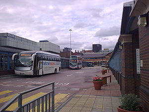
Sheffield is also served by a number of coach services. National Express Coaches provides most services, using Sheffield Interchange, Meadowhall Interchange
Meadowhall Interchange
Meadowhall Interchange to the north of Sheffield, South Yorkshire, England is a railway station on the Midland Main Line, a Sheffield Supertram stop, and bus station. It is close to junction 34 on the M1, and serves Meadowhall Shopping Centre...
and Meadowhead Bus stop as pick up/drop off points. Sheffield Interchange handles most services and is the start point/terminus for a number of them. Sheffield is connected to London Victoria by the 560 - 564 services, with Sheffield serving as the terminus/starting point on some occasions (on others, it will be Rotherham, Barnsley, Leeds or Halifax).
Being at the confluence of several natural waterways, the development of a canal system marked an important evolution in the city's transport network, initially for commercial use and, more recently, for leisure activities. The Sheffield and South Yorkshire Navigation
Sheffield and South Yorkshire Navigation
The Sheffield and South Yorkshire Navigation is a system of navigable inland waterways in South Yorkshire and Lincolnshire, England....
(S&SY) is a system of navigable inland waterways (canals and canalised rivers) in Yorkshire and Lincolnshire
Lincolnshire
Lincolnshire is a county in the east of England. It borders Norfolk to the south east, Cambridgeshire to the south, Rutland to the south west, Leicestershire and Nottinghamshire to the west, South Yorkshire to the north west, and the East Riding of Yorkshire to the north. It also borders...
, England.
Chiefly based on the River Don, it runs for a length of 43 miles (69 km) and has 29 locks. It connects Sheffield, Rotherham
Rotherham
Rotherham is a town in South Yorkshire, England. It lies on the River Don, at its confluence with the River Rother, between Sheffield and Doncaster. Rotherham, at from Sheffield City Centre, is surrounded by several smaller settlements, which together form the wider Metropolitan Borough of...
, and Doncaster
Doncaster
Doncaster is a town in South Yorkshire, England, and the principal settlement of the Metropolitan Borough of Doncaster. The town is about from Sheffield and is popularly referred to as "Donny"...
with the River Trent
River Trent
The River Trent is one of the major rivers of England. Its source is in Staffordshire on the southern edge of Biddulph Moor. It flows through the Midlands until it joins the River Ouse at Trent Falls to form the Humber Estuary, which empties into the North Sea below Hull and Immingham.The Trent...
at Keadby
Keadby
Keadby is a small village lying just off the A18, west of Scunthorpe, in North Lincolnshire, England. It lies on the West bank of the River Trent. It is pronounced "Kidby"....
and (via the New Junction Canal
New Junction Canal
The New Junction Canal is a canal in South Yorkshire, England. It is part of the Sheffield and South Yorkshire Navigation , although it was jointly funded by the Aire and Calder Navigation, and was opened in 1905. It links the River Don Navigation and the Stainforth and Keadby Canal with the Aire...
) the Aire and Calder Navigation
Aire and Calder Navigation
The Aire and Calder Navigation is a river and canal system of the River Aire and the River Calder in the metropolitan county of West Yorkshire, England. The first improvements to the rivers above Knottingley were completed in 1704 when the Aire was made navigable to Leeds and the Calder to...
.
Local travel
A57 road
The A57 is a major road in England. It runs east from Liverpool to Lincoln, via Warrington, Cadishead, Irlam, Patricroft, Eccles, Salford and Manchester, then through the Pennines over the Snake Pass , around the Ladybower Reservoir, through Sheffield and past Worksop...
and A61
A61 road
The A61 is a major trunk road in England. It runs from Derby to Thirsk in North Yorkshire. From Derby, it heads north via Alfreton, Clay Cross, Chesterfield, Sheffield, Barnsley, Wakefield, Leeds, Harrogate and Ripon...
roads are the major trunk roads through Sheffield. These run east-west and north-south, respectively, crossing in the city centre. Other major roads generally radiate spoke-like from the city centre. An inner ring road
Ring road
A ring road, orbital motorway, beltway, circumferential highway, or loop highway is a road that encircles a town or city...
, mostly constructed in the 1970s and extended to form a complete ring in 2007-2008, allows traffic to avoid the city centre, and an outer "ring road" runs around the eastern edge of the city. The inner ring-road follows St Mary's Road, Upper Hanover Street and then traverses Netherthorpe, to reach Shalesmoor. The Sheffield Outer Ring Road
Sheffield Outer Ring Road
Sheffield Outer Ring Road is one of two main routes circumventing Sheffield, a partial ring around Sheffield City Centre and its suburbs.It begins in Bradway as the B6054 Bradway Road, progressing anticlockwise as Greenhill Parkway, crossing the A61 Meadowhead/Chesterfield Road South into the A6102...
follows much of Prince of Wales Road from 'Arena Square' in Carbrook
Carbrook, South Yorkshire
Carbrook is an industrial area of Sheffield, South Yorkshire, England to the north-east of Brightside. The suburb is named for the Carr Brook, which ran through the area until the late eighteenth century....
to Greenhill at Greenhill roundabout where it joins the A61
A61 road
The A61 is a major trunk road in England. It runs from Derby to Thirsk in North Yorkshire. From Derby, it heads north via Alfreton, Clay Cross, Chesterfield, Sheffield, Barnsley, Wakefield, Leeds, Harrogate and Ripon...
.
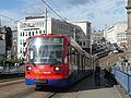
Public transport is provided by tram
Tram
A tram is a passenger rail vehicle which runs on tracks along public urban streets and also sometimes on separate rights of way. It may also run between cities and/or towns , and/or partially grade separated even in the cities...
s and bus
Bus
A bus is a road vehicle designed to carry passengers. Buses can have a capacity as high as 300 passengers. The most common type of bus is the single-decker bus, with larger loads carried by double-decker buses and articulated buses, and smaller loads carried by midibuses and minibuses; coaches are...
es. The Tramway system, known as the "Sheffield Supertram
Sheffield Supertram
The Supertram, officially called the Stagecoach Supertram, is a light rail tram system in the City of Sheffield, South Yorkshire, England...
", is operated by Stagecoach Sheffield
Stagecoach Sheffield
Stagecoach Sheffield is a bus operator based in Sheffield, England, a subsidiary of the Stagecoach Group. It was formed from the Sheffield based operations of the Yorkshire Traction Group, purchased by Stagecoach in 2005...
under the brand Stagecoach Supertram. It was constructed in the early 1990s, with the first section opening in 1994 and consists of three spokes that run from the city centre out to Hillsborough
Hillsborough, South Yorkshire
Hillsborough is an electoral ward which includes the districts of Malin Bridge, Owlerton, Wadsley and Wisewood. It is one of the 28 electoral wards in City of Sheffield, England. It is located in the northwestern part of the city and covers an area of 4.6 km2...
, Halfway, and Meadowhall
Meadowhall
Meadowhall is an indoor shopping centre in Sheffield, South Yorkshire, England. It lies three miles north east of Sheffield city centre and four miles from Rotherham town centre....
.
A sizeable bus infrastructure operates from a main hub at Sheffield Interchange. Other bus stations lie at Meadowhall and Hillsborough.
Stagecoach Group
Stagecoach Group plc is an international transport group operating buses, trains, trams, express coaches and ferries. The group was founded in 1980 by the current chairman, Sir Brian Souter, his sister, Ann Gloag, and her former husband Robin...
took over Yorkshire Traction
Yorkshire Traction
Yorkshire Traction was a bus operator in South Yorkshire. Between 1986 and 2005 it was a key part of the Traction Group. In December 2005 it was sold to the Stagecoach Group.-History:...
(which had previously taken over Yorkshire Terrier, creating Stagecoach Sheffield
Stagecoach Sheffield
Stagecoach Sheffield is a bus operator based in Sheffield, England, a subsidiary of the Stagecoach Group. It was formed from the Sheffield based operations of the Yorkshire Traction Group, purchased by Stagecoach in 2005...
). Stagecoach In Yorkshire
Stagecoach Yorkshire
Stagecoach Yorkshire is an operating division of Stagecoach UK Bus.It was formed in 2005 to take over the former Traction Group fleets in Yorkshire by Stagecoach Group, which took over Traction from Frank Carter on 14 December 2005; Yorkshire Traction, Yorkshire Terrier and Barnsley & District....
, Stagecoach In Chesterfield
Stagecoach in Chesterfield
Stagecoach in Chesterfield is the sector of the Stagecoach Group that operates buses in Chesterfield, Derbyshire, England.They currently carry over eight million passengers per year, experiencing a year on year passenger increase of around 10% in recent years...
, Stagecoach In Mansfield
Stagecoach in Mansfield
Stagecoach in Mansfield is the sector of the Stagecoach Group that operates buses in Mansfield. They have around 60 buses and 200 employees.They carry over 6 million passengers per year, with a passenger increase of approximately 7%....
, Veolia Transport (Operating for Travel South Yorkshire), Sheffield Community Transport
Sheffield Community Transport
Sheffield Community Transport is a non-governmental organisation with charitable status which provides transport services in Sheffield. Funding from SPT comes from South Yorkshire Passenger Transport Executive , Sheffield City Council, South Yorkshire Objective 1 programme, Yorkshire Forward,...
(SCT), Hulleys of Baslow
Hulleys of Baslow
Henry Hulley and Sons Ltd, trading as Hulleys of Baslow, is a bus company based in Baslow, Derbyshire, England. It has been in business for over eighty years. As well as operating scheduled bus services and school contracts, it also operates chartered coach services. The company comprises 16...
, Powell's Co, K&H Doyle also operating bus routes in the city. A city centre free bus service also runs every 7 minutes, known as the FreeBee.
For cycling, although the city is hilly, Sheffield is compact and has few major trunk roads running through it. It is on the Trans-Pennine Trail, a National Cycle Network
National Cycle Network
The National Cycle Network is a network of cycle routes in the United Kingdom.The National Cycle Network was created by the charity Sustrans , and aided by a £42.5 million National Lottery grant. In 2005 it was used for over 230 million trips.Many routes hope to minimise contact with motor...
route running from Southport
Southport
Southport is a seaside town in the Metropolitan Borough of Sefton in Merseyside, England. During the 2001 census Southport was recorded as having a population of 90,336, making it the eleventh most populous settlement in North West England...
in the north-west to Hornsea
Hornsea
Hornsea is a small seaside resort, town and civil parish in the East Riding of Yorkshire, England at the eastern end of the Trans Pennine Trail.-Overview:According to the 2001 UK Census, Hornsea parish had a population of 8,243....
in the East Riding
East Riding of Yorkshire
The East Riding of Yorkshire, or simply East Yorkshire, is a local government district with unitary authority status, and a ceremonial county of England. For ceremonial purposes the county also includes the city of Kingston upon Hull, which is a separate unitary authority...
, and has a developing Strategic Cycle Network within the city. Sheffield is close to the Peak District National Park, an area of outstanding natural beauty popular with both on and off-road cyclists.
Early history
The earliest known roads in the Sheffield area date from the Roman occupation of BritainRoman Britain
Roman Britain was the part of the island of Great Britain controlled by the Roman Empire from AD 43 until ca. AD 410.The Romans referred to the imperial province as Britannia, which eventually comprised all of the island of Great Britain south of the fluid frontier with Caledonia...
between 43 and 410 AD. The Romans built a fort at Templeborough
Templeborough
Templeborough is a suburb of Rotherham, South Yorkshire, England. The area takes its name from the remains of the Roman fort found there which were mistakenly believed to be that of a Roman Temple.-Roman fort:...
c55. Two roads
Roman roads in Britain
Roman roads, together with Roman aqueducts and the vast standing Roman army , constituted the three most impressive features of the Roman Empire. In Britain, as in other provinces, the Romans constructed a comprehensive network of paved trunk roads Roman roads, together with Roman aqueducts and the...
were built to this fort. Icknield Street
Icknield Street
Icknield Street or Ryknild Street is a Roman road in Britain that runs from the Fosse Way at Bourton on the Water in Gloucestershire to Templeborough in South Yorkshire...
ran south towards Derby
Derby
Derby , is a city and unitary authority in the East Midlands region of England. It lies upon the banks of the River Derwent and is located in the south of the ceremonial county of Derbyshire. In the 2001 census, the population of the city was 233,700, whilst that of the Derby Urban Area was 229,407...
, and another road ran south-west to Brough-on-Noe near Hope
Hope, Derbyshire
Hope is a village in the Derbyshire Peak District, in England. It lies in the Hope Valley, at the point where Peakshole Water flows into the River Noe. To the north, Win Hill and Lose Hill stand either side of the Noe....
in Derbyshire
Derbyshire
Derbyshire is a county in the East Midlands of England. A substantial portion of the Peak District National Park lies within Derbyshire. The northern part of Derbyshire overlaps with the Pennines, a famous chain of hills and mountains. The county contains within its boundary of approx...
. The exact course of these roads is unknown but both are likely to have passed within the modern boundaries Sheffield. In the centuries after the end of the Roman occupation the Sheffield area was at the border of the Anglo-Saxon kingdoms of Northumbria
Northumbria
Northumbria was a medieval kingdom of the Angles, in what is now Northern England and South-East Scotland, becoming subsequently an earldom in a united Anglo-Saxon kingdom of England. The name reflects the approximate southern limit to the kingdom's territory, the Humber Estuary.Northumbria was...
and Mercia
Mercia
Mercia was one of the kingdoms of the Anglo-Saxon Heptarchy. It was centred on the valley of the River Trent and its tributaries in the region now known as the English Midlands...
. The village of Dore
Dore
Dore is a village in South Yorkshire, England. The village lies on a hill above the River Sheaf, and until 1934 was part of Derbyshire, but it is now a suburb of Sheffield. It is served by Dore and Totley railway station on the Hope Valley Line...
(literally a Door) lay on an important route between these kingdoms.
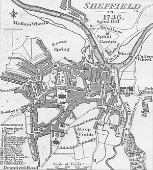
Norman conquest of England
The Norman conquest of England began on 28 September 1066 with the invasion of England by William, Duke of Normandy. William became known as William the Conqueror after his victory at the Battle of Hastings on 14 October 1066, defeating King Harold II of England...
a castle was established in the village of Sheffield c1150. Sheffield began to grow into a small town, the first bridge was built over the River Don (Lady's Bridge
Lady's Bridge
Lady's Bridge is the oldest bridge across the River Don in the City of Sheffield, England. It is located in the central section of the city, linking the Wicker to the north with Waingate to the south.-The first bridge:...
) and the street pattern that would persist for centuries was laid out. Lady's Bridge may represent the main route out of Sheffield in this era, travellers followed the Wicker and then climbed Spital Hill to follow an ancient Dyke called the "Roman Rig" to Mexborough
Mexborough
Mexborough is a town in the metropolitan borough of Doncaster, South Yorkshire, England, situated on the north bank of the River Don west of its confluence with the River Dearne...
. This may be the route into Sheffield described in Sir Walter Scott's
Walter Scott
Sir Walter Scott, 1st Baronet was a Scottish historical novelist, playwright, and poet, popular throughout much of the world during his time....
Ivanhoe
Ivanhoe
Ivanhoe is a historical fiction novel by Sir Walter Scott in 1819, and set in 12th-century England. Ivanhoe is sometimes credited for increasing interest in Romanticism and Medievalism; John Henry Newman claimed Scott "had first turned men's minds in the direction of the middle ages," while...
. A route to the south passing through Little Sheffield, Heeley, and Newfield Green, to Gleadless Moor existed by 1692, but was a difficult route to follow. There was also a route to the west that followed the old Roman Road toward Stanage Edge, however Sheffield remained relatively secluded, a fact which may have influenced the choice of Sheffield for the imprisonment of Mary, Queen of Scots, in 1570.
In the 18th century, turnpike
Turnpike trust
Turnpike trusts in the United Kingdom were bodies set up by individual Acts of Parliament, with powers to collect road tolls for maintaining the principal highways in Britain from the 17th but especially during the 18th and 19th centuries...
roads were built improving Sheffield's connections with the outside world. A turnpike to Chesterfield
Chesterfield
Chesterfield is a market town and a borough of Derbyshire, England. It lies north of Derby, on a confluence of the rivers Rother and Hipper. Its population is 70,260 , making it Derbyshire's largest town...
was built in 1756 and another through Ringinglow
Ringinglow
Ringinglow is a village in the western section of Sheffield, England. It is on the western border of Ecclesall Ward, and although it is within the boundary of Sheffield, it is self-contained, being entirely surrounded by open countryside....
to Chapel-en-le-Frith
Chapel-en-le-Frith
Chapel-en-le-Frith is a small town in Derbyshire, England, on the edge of the Peak District near the border with Cheshire, from Manchester. Dubbed "The Capital of the Peak District", the settlement was established by the Normans in the 12th century, originally as a hunting lodge within the Forest...
or Buxton
Buxton
Buxton is a spa town in Derbyshire, England. It has the highest elevation of any market town in England. Located close to the county boundary with Cheshire to the west and Staffordshire to the south, Buxton is described as "the gateway to the Peak District National Park"...
was constructed in 1758. Roads were also built to Barnsley, Tickhill, Worksop, Intake and Penistone. The Baslow
Baslow
Baslow is a village in Derbyshire, England, in the Peak District, lying between Sheffield and Bakewell. It is situated on the River Derwent just north of Chatsworth House. A seventeenth century bridge spans the river in the village, alongside which is a contemporary toll house...
turnpike (Abbeydale Road) opened in 1805 and Glossop Road opened in 1821. In 1774 a wooden waggonway was laid over a distance of 2 miles from the Duke of Norfolk's collieries into the town, this was later relaid with cast-iron L-shaped rails by John Curr
John Curr
John Curr was the manager of the Duke of Norfolk's collieries in Sheffield, England from 1781 to 1801. During this time he made a number of innovations that contributed significantly to the development of the coal mining industry and railways.-Personal life:Curr was born in County Durham, England...
; one of the earliest railways to use this type of rails.
19th century
The opening of the Sheffield CanalSheffield Canal
The Sheffield Canal is a canal in the City of Sheffield, England. It runs from Tinsley, where it leaves the River Don, to the Sheffield Canal Basin in the city centre, passing through 11 locks.- Early history :...
in 1819 opened Sheffield to the large-scale transportation of freight. This was followed by the Sheffield and Rotherham Railway
Sheffield and Rotherham Railway
The Sheffield and Rotherham Railway was a short railway between Sheffield and Rotherham and the first in the two towns.In the early nineteenth century, when news broke of the building of the North Midland Railway, it was clear that George Stephenson would follow the gentle gradient of the Rivers...
in 1838, with Sheffield's first railway station opening at the Wicker. The first main line railway station in Sheffield was opened in 1845 at Bridgehouses
Bridgehouses railway station
Bridgehouses railway station was the terminal station of the Sheffield, Ashton-under-Lyne and Manchester Railway from its opening in 1845 until the opening of the Wicker Arches, a long viaduct across the Don Valley, which supported the new Sheffield Victoria opened on 15 September 1851...
by the Sheffield, Ashton-under-Lyne and Manchester Railway
Sheffield, Ashton-Under-Lyne and Manchester Railway
The Sheffield, Ashton-under-Lyne and Manchester Railway was an early British railway company which opened in stages between 1841 and 1845 between Sheffield and Manchester via Ashton-under-Lyne...
. This line was extended to a new station, Sheffield Victoria Station
Sheffield Victoria Station
Sheffield Victoria was the main railway station in Sheffield, South Yorkshire, England on the Great Central Railway, between Chesterfield and Penistone.-Early history:...
in 1851, and Wicker station was replaced by Sheffield Midland station
Sheffield Midland station
Sheffield station, formerly Pond Street and later Sheffield Midland, is a railway station in Sheffield, England and is the busiest station in South Yorkshire...
in 1870. A horse tramway opened from Lady's Bridge to Attercliffe
Attercliffe
Attercliffe is an industrial suburb of northeast Sheffield, England on the south bank of the River Don.-History:The name Attercliffe can be traced back as far as an entry in the Domesday book -Ateclive- meaning at the cliffe, a small escarpment that lay alongside the River Don...
in 1873, this was later extended to Brightside
Brightside, South Yorkshire
Brightside is an industrial area of Sheffield, South Yorkshire, England lying on a hill north of Attercliffe and the River Don.Brightside was recorded in the fifteenth century as "Brekesherth", when it was home to some mills...
and Tinsley
Tinsley, South Yorkshire
Tinsley is a suburb of northeastern part of Sheffield, South Yorkshire. Its name derives from the Old English Tingas-Leah, which means 'Field of Council'...
. Further horse tramway
Sheffield Tramway
Sheffield Tramway was an extensive tramway network serving the English city of Sheffield and its suburbs.The first tramway line, horse-drawn, opened in 1873 between Lady's Bridge and Attercliffe, subsequently extended to Brightside and Tinsley...
routes were constructed to Hillsborough
Hillsborough, South Yorkshire
Hillsborough is an electoral ward which includes the districts of Malin Bridge, Owlerton, Wadsley and Wisewood. It is one of the 28 electoral wards in City of Sheffield, England. It is located in the northwestern part of the city and covers an area of 4.6 km2...
, Heeley
Heeley
Heeley is a former cluster of villages now a suburb in the south of the City of Sheffield, England. The village has existed at least since 1343, its name deriving from Heah Leah, High Lea then Hely, meaning a high, woodland clearing...
, and Nether Edge
Nether Edge
Nether Edge Ward—which includes the districts of Brincliffe, Carter Knowle, Nether Edge, Sharrow Vale, and most of Banner Cross—is one of the 28 electoral wards in the City of Sheffield, England. It is located in the southern part of the city and covers an area of 3.4 km2...
. There was an unsuccessful trial of Steam trams in 1877 and 1878. Due to the narrow medieval roads the tramways were initially banned from the town centre. An improvement scheme was passed in 1875, this led to the first major alterations to the medieval street plan, Pinstone Street and Leopold Street were constructed by 1879 and Fargate was widened in the 1880s. The 1875 plan also called for the widening of High Street, but disputes with property owners delayed this until 1895.
The S&SY Navigation company was formed in 1888 with the intention of purchasing all of the waterways which were then owned by Manchester, Sheffield and Lincolnshire Railway
Manchester, Sheffield and Lincolnshire Railway
The Manchester, Sheffield and Lincolnshire Railway was formed by amalgamation in 1847. The MS&LR changed its name to the Great Central Railway in 1897 in anticipation of the opening in 1899 of its London Extension.-Origin:...
. After seven years of negotiation, this was accomplished in 1895, and the navigation was formed by the amalgamation of the component waterways which included the Stainforth and Keadby Canal
Stainforth and Keadby Canal
The Stainforth and Keadby Canal is a navigable canal in South Yorkshire and Lincolnshire, England. It connects the River Don Navigation at Bramwith to the River Trent at Keadby, by way of Stainforth, Thorne and Ealand, near Crowle.-History:...
, the River Don Navigation
River Don Navigation
The River Don Navigation was the result of early efforts to make the River Don in South Yorkshire, England, navigable between Fishlake and Sheffield...
, and the Sheffield and Tinsley Canal
Sheffield Canal
The Sheffield Canal is a canal in the City of Sheffield, England. It runs from Tinsley, where it leaves the River Don, to the Sheffield Canal Basin in the city centre, passing through 11 locks.- Early history :...
.
20th century to the present
National Tramway Museum
The National Tramway Museum, at Crich, in Derbyshire, England, is situated within Crich Tramway Village, a period village containing a pub, cafe, old-style sweetshop, including the tram depots. The village is also home to the Eagle Press, a small museum dedicated to Letterpress Printing including...
in Crich
Crich
Crich is a village in Derbyshire in England. It has the National Tramway Museum inside the Crich Tramway Village, and at the summit of Crich Hill above, a Memorial Tower for those of the Sherwood Foresters regiment who died in battle, particularly in World War I.Built in 1923 on the site of an...
). The Beeching Axe
Beeching Axe
The Beeching Axe or the Beeching Cuts are informal names for the British Government's attempt in the 1960s to reduce the cost of running British Railways, the nationalised railway system in the United Kingdom. The name is that of the main author of The Reshaping of British Railways, Dr Richard...
led to the closure of the Great Central Railway
Great Central Railway
The Great Central Railway was a railway company in England which came into being when the Manchester, Sheffield and Lincolnshire Railway changed its name in 1897 in anticipation of the opening in 1899 of its London Extension . On 1 January 1923, it was grouped into the London and North Eastern...
route to London in 1966, followed by the Woodhead route to Manchester in 1970. This left Victoria station obsolete; it closed on 5 January 1970 and the station buildings were demolished in 1989, leaving the Wicker Arches
Wicker Arches
The Wicker Arches form a long railway viaduct across the Don Valley in the City of Sheffield, England. They take their name from the thoroughfare The Wicker, which passes through the main arch of the viaduct and was, until the completion of the Sheffield Parkway, the main route eastwards from the...
on which it stood standing. Proposals for a new tram system first appeared in the 1970s. After much deliberation routes were selected and construction of the new system, named Sheffield Supertram
Sheffield Supertram
The Supertram, officially called the Stagecoach Supertram, is a light rail tram system in the City of Sheffield, South Yorkshire, England...
started in 1991. The first line, running from Castle Square
Castle Square, Sheffield
Castle Square is the plaza at the intersection of High Street, Angel Street, and Arundel Gate in the City of Sheffield, England. This name was given to the square in the 1960s to reflect the proximity of the square to the site of Sheffield Castle, which was formerly located a short distance to the...
to Meadowhall
Meadowhall
Meadowhall is an indoor shopping centre in Sheffield, South Yorkshire, England. It lies three miles north east of Sheffield city centre and four miles from Rotherham town centre....
opened on 21 March 1994.
South Yorkshire County Council (SYCC) was created in 1974, comprising several neighbouring metropolitan boroughs; Sheffield, Barnsley, Doncaster and Rotherham. The metropolitan county councils created at this time, were given the responsibility for the provision of public transport. In the case of the SYCC this was allocated to the new South Yorkshire Passenger Transport Executive (SYPTE). SYPTE assumed control of the former local corporation bus fleets and also took on a coordinating role regarding the services provided by other bus operators and by British Rail
British Rail
British Railways , which from 1965 traded as British Rail, was the operator of most of the rail transport in Great Britain between 1948 and 1997. It was formed from the nationalisation of the "Big Four" British railway companies and lasted until the gradual privatisation of British Rail, in stages...
in their region, in addition to becoming the highway authority
Highway Authority
A highway authority is a name given to a body responsible for the administration of public roads.-India:The National Highways Authority of India is the national authority for the management of a network of over 60,000 km of National Highways in India...
for the area. During this period bus services received a subsidy of up to 85% of operating costs, and low fares contributed to an increase in bus travel of 7% from 1974–1984, compared with a 30% decline elsewhere in the United Kingdom.
The metropolitan county councils, were abolished in 1986 but, despite the disappearance of the SYCC, the SYPTE remained, under the control of a Passenger Transport Authority (SYPTA) which included the four borough councils involved. By contrast, the functions of local highway authority
Highway Authority
A highway authority is a name given to a body responsible for the administration of public roads.-India:The National Highways Authority of India is the national authority for the management of a network of over 60,000 km of National Highways in India...
passed directly to each of the councils, and the Sheffield City Council (SCC) thus became the responsible for city's highways.
Deregulation of UK bus services in 1986 brought an end to the local authority's direct control of the provision of local bus services, in essence leaving the bus companies to decide where, when and how often to run services, and compete commercially with each other although SYPTE still maintains an advisory role and funds the running of some non-commercially viable routes that are considered socially essential.