

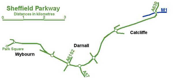
Sheffield Parkway
Encyclopedia
Dual carriageway
A dual carriageway is a class of highway with two carriageways for traffic travelling in opposite directions separated by a central reservation...
which runs between the City of Sheffield
Sheffield
Sheffield is a city and metropolitan borough of South Yorkshire, England. Its name derives from the River Sheaf, which runs through the city. Historically a part of the West Riding of Yorkshire, and with some of its southern suburbs annexed from Derbyshire, the city has grown from its largely...
and junction 33 of the M1
M1 motorway
The M1 is a north–south motorway in England primarily connecting London to Leeds, where it joins the A1 near Aberford. While the M1 is considered to be the first inter-urban motorway to be completed in the United Kingdom, the first road to be built to motorway standard in the country was the...
in South Yorkshire
South Yorkshire
South Yorkshire is a metropolitan county in the Yorkshire and the Humber region of England. It has a population of 1.29 million. It consists of four metropolitan boroughs: Barnsley, Doncaster, Rotherham, and City of Sheffield...
, England
England
England is a country that is part of the United Kingdom. It shares land borders with Scotland to the north and Wales to the west; the Irish Sea is to the north west, the Celtic Sea to the south west, with the North Sea to the east and the English Channel to the south separating it from continental...
. The 5.5 mile road was opened in 1974, and runs to the east of the City, connecting Park Square in the City centre with the inner ring road
Sheffield Inner Ring Road
Sheffield Inner Ring Road is a dual-carriageway circling central Sheffield, South Yorkshire, England. Built from the 1960s onwards the Ring Road connects to the Sheffield Parkway, which itself connects with the M1 motorway...
, outer ring road
Sheffield Outer Ring Road
Sheffield Outer Ring Road is one of two main routes circumventing Sheffield, a partial ring around Sheffield City Centre and its suburbs.It begins in Bradway as the B6054 Bradway Road, progressing anticlockwise as Greenhill Parkway, crossing the A61 Meadowhead/Chesterfield Road South into the A6102...
and out to the M1 motorway
M1 motorway
The M1 is a north–south motorway in England primarily connecting London to Leeds, where it joins the A1 near Aberford. While the M1 is considered to be the first inter-urban motorway to be completed in the United Kingdom, the first road to be built to motorway standard in the country was the...
at junction 33. On this route it passes the districts of Wybourn, Darnall
Darnall
Darnall ward—which includes the districts of Attercliffe, Carbrook, Darnall, Tinsley, and parts of Handsworth—is one of the 28 electoral wards in City of Sheffield, South Yorkshire, England. It is located in the eastern part of the city and covers an area of 17.4 km2. The...
, Handsworth
Handsworth, South Yorkshire
Handsworth is a suburb of south eastern Sheffield, in South Yorkshire, England. Handsworth has a population of approximately 15,000. It covers an overall area of approximately...
, and the village of Catcliffe
Catcliffe
Catcliffe is a village and civil parish on the north-west bank of the River Rother in South Yorkshire, England. It is located in the Metropolitan Borough of Rotherham, about south of the town of Rotherham and east of Sheffield City Centre.-History:...
, at which a slip road connects to the now defunct Sheffield City Airport
Sheffield City Airport
Sheffield City Airport was a small airport located in Sheffield that is now closed. It was located in the Tinsley Park area of the city, near the M1 motorway and Sheffield Parkway, and opened in 1997...
, Sheffield Business Park and the Advanced Manufacturing Park (AMP). Many businesses and Sheffield attractions are located close to the Parkway as it is known in Sheffield, and it can become highly congested. For approximately 2.5 miles of its route the road forms a part of the A57 road
A57 road
The A57 is a major road in England. It runs east from Liverpool to Lincoln, via Warrington, Cadishead, Irlam, Patricroft, Eccles, Salford and Manchester, then through the Pennines over the Snake Pass , around the Ladybower Reservoir, through Sheffield and past Worksop...
, the rest being part of the A630 road.
Junctions
| Parkway | ||
| Type | Destinations | Roads |
| Terminus Roundabout | Rotherham Rotherham Rotherham is a town in South Yorkshire, England. It lies on the River Don, at its confluence with the River Rother, between Sheffield and Doncaster. Rotherham, at from Sheffield City Centre, is surrounded by several smaller settlements, which together form the wider Metropolitan Borough of... |
M1, A630 |
| Grade separated Roundabout | Catcliffe Catcliffe Catcliffe is a village and civil parish on the north-west bank of the River Rother in South Yorkshire, England. It is located in the Metropolitan Borough of Rotherham, about south of the town of Rotherham and east of Sheffield City Centre.-History:... |
B6533 |
| Grade separated Roundabout | Handsworth Handsworth, South Yorkshire Handsworth is a suburb of south eastern Sheffield, in South Yorkshire, England. Handsworth has a population of approximately 15,000. It covers an overall area of approximately... , Darnall Darnall Darnall ward—which includes the districts of Attercliffe, Carbrook, Darnall, Tinsley, and parts of Handsworth—is one of the 28 electoral wards in City of Sheffield, South Yorkshire, England. It is located in the eastern part of the city and covers an area of 17.4 km2. The... |
B6200 |
| Grade separated diamond Diamond interchange A diamond interchange is a common type of road junction, used where a freeway crosses a minor road. The freeway itself is grade-separated from the minor road, one crossing the other over a bridge... |
Mosborough Mosborough Mosborough ward — which includes the districts of Halfway, Mosborough village, Waterthorpe, and Westfield — is one of the 28 electoral wards in City of Sheffield, England. It is located in the eastern part of the city, on the border with Rotherham, and covers an area of 8.9 km2.... |
A57, A6102 (westbound only) |
| Grade separated Roundabout (No exit westbound) | Outer ring road Sheffield Outer Ring Road Sheffield Outer Ring Road is one of two main routes circumventing Sheffield, a partial ring around Sheffield City Centre and its suburbs.It begins in Bradway as the B6054 Bradway Road, progressing anticlockwise as Greenhill Parkway, crossing the A61 Meadowhead/Chesterfield Road South into the A6102... |
A6102 |
| Trumpet | Parkway Industrial Estate | |
| West bound exit sliproad | Attercliffe Attercliffe Attercliffe is an industrial suburb of northeast Sheffield, England on the south bank of the River Don.-History:The name Attercliffe can be traced back as far as an entry in the Domesday book -Ateclive- meaning at the cliffe, a small escarpment that lay alongside the River Don... , Manor Manor, South Yorkshire Manor Castle ward—which includes the districts of Claywood, Manor, Manor Park, Park Hill, and Wybourn—is one of the 28 electoral wards in City of Sheffield, England. It is located in the eastern part of the city and covers an area of 5.4 km2. The population of this ward in 2001 was... |
|
| At grade roundabout | Inner ring road Sheffield Inner Ring Road Sheffield Inner Ring Road is a dual-carriageway circling central Sheffield, South Yorkshire, England. Built from the 1960s onwards the Ring Road connects to the Sheffield Parkway, which itself connects with the M1 motorway... |
A61 |
| Terminus roundabout | Sheffield City Centre Sheffield City Centre Sheffield City Centre—often just referred to as town—is a district of the City of Sheffield, and part of the Sheffield Central ward. It includes the area that is within a radius of roughly of Sheffield Cathedral, and is encircled by the Inner Ring Road—a circular route started in the late 1960s... |
A61, A6135 |