

National Cycle Network
Encyclopedia
Bicycle
A bicycle, also known as a bike, pushbike or cycle, is a human-powered, pedal-driven, single-track vehicle, having two wheels attached to a frame, one behind the other. A person who rides a bicycle is called a cyclist, or bicyclist....
routes in the United Kingdom
United Kingdom
The United Kingdom of Great Britain and Northern IrelandIn the United Kingdom and Dependencies, other languages have been officially recognised as legitimate autochthonous languages under the European Charter for Regional or Minority Languages...
.
The National Cycle Network was created by the charity Sustrans
Sustrans
Sustrans is a British charity to promote sustainable transport. The charity is currently working on a number of practical projects to encourage people to walk, cycle and use public transport, to give people the choice of "travelling in ways that benefit their health and the environment"...
(Sustainable Transport), and aided by a £42.5 million National Lottery grant. In 2005 it was used for over 230 million trips.
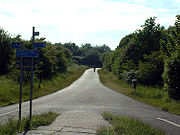
Many routes hope to minimise contact with motor traffic, though 70% of them are on roads. In some cases the NCN uses pedestrian routes, disused railways
Rail trail
A rail trail is the conversion of a disused railway easement into a multi-use path, typically for walking, cycling and sometimes horse riding. The characteristics of former tracks—flat, long, frequently running through historical areas—are appealing for various development. The term sometimes also...
, minor roads, canal towpaths, or traffic-calmed routes in towns and cities. Some places have more off-road paths than others - Stoke-on-Trent
Stoke-on-Trent
Stoke-on-Trent , also called The Potteries is a city in Staffordshire, England, which forms a linear conurbation almost 12 miles long, with an area of . Together with the Borough of Newcastle-under-Lyme Stoke forms The Potteries Urban Area...
, for instance, uses canal towpaths and its old mineral/clay railway network to provide over 100 miles (160.9 km) of off-road paths through the city.
Total national mileage
The original goal was to create 5000 miles (8,046.7 km) of signed cycle routes by 2005, with 50% of these not being on roads, and all of it being "suitable for an unsupervised twelve year old." By mid 2000 5000 miles (8,046.7 km) of route were signposted to an "interim" standard, and a new goal was then set to double that to 10000 miles (16,093.4 km) by 2005. August 2005 saw the completion of that goal. As of mid-2011, the total stands at 13000 miles (20,921.4 km) of signed cycle route at NCN standard.Numbering system
National Cycle Network routes beginning with numbers 1 to 6 are generally in England, while those beginning with 7 start in the far north of England and Scotland. Those beginning with 8 are generally in Wales, and 9 in Northern Ireland. The main routes have one digit (1 to 6 radiate clockwise from the south of England). Other NCN routes have two digits, starting with the number of the relevant main route.There are also many regional routes, reaching smaller towns and cities within ten designated regions. Each region is divided into a maximum of 9 areas. Regional route numbers comprise the area number 1 to 9, followed by another digit. (An exception is in the Scottish Borders council area, where the regional routes are numbered 1 to 9.) This means that across the UK there could be 10 regional route 12s, for instance, as well as the national route 12. To reduce confusion, identically numbered areas in adjacent regions do not abut, and so routes with the same number are widely separated.
As of 2009, regional routes are being renumbered with 3-digit national numbers.
Routes are occasionally numbered to match the names of major roads and motorways which connect the same destinations; examples of this practice include the NCN Route 62, which by connecting the two sides of the Pennines
Pennines
The Pennines are a low-rising mountain range, separating the North West of England from Yorkshire and the North East.Often described as the "backbone of England", they form a more-or-less continuous range stretching from the Peak District in Derbyshire, around the northern and eastern edges of...
mirrors the M62 motorway
M62 motorway
The M62 motorway is a west–east trans-Pennine motorway in Northern England, connecting the cities of Liverpool and Hull via Manchester and Leeds. The road also forms part of the unsigned Euroroutes E20 and E22...
.
Signing
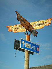
Mileposts
1000 Millennium cast iron mileposts funded by the Royal Bank of ScotlandRoyal Bank of Scotland
The Royal Bank of Scotland Group is a British banking and insurance holding company in which the UK Government holds an 84% stake. This stake is held and managed through UK Financial Investments Limited, whose voting rights are limited to 75% in order for the bank to retain its listing on the...
to mark the creation of the National Cycle Network, and found along the cycles routes through the UK.
There are four different types of posts, "Fossil Tree" (designed by John Mills), "The Cockerel" (designed by Iain McColl), Rowe Type by Andrew Rowe, and "Tracks" (designed by David Dudgeon). The four artists are from each country of the UK, though all posts can be found in all four countries.
See also
- The National BywayThe National BywayThe National Byway is a 4,500-mile sign-posted cycling route round England and parts of Scotland and Wales. It runs along quiet roads, rather than a mixture of roads and tracks like the National Cycle Network, making it more appropriate for road bikes...
- an alternative 4500 miles (7,242 km) sign-posted cycle network around Britain - Segregated cycle facilitiesSegregated cycle facilitiesSegregated cycle facilities are marked lanes, tracks, shoulders and paths designated for use by cyclists from which motorised traffic is generally excluded...
- List of rail trails
- SustransSustransSustrans is a British charity to promote sustainable transport. The charity is currently working on a number of practical projects to encourage people to walk, cycle and use public transport, to give people the choice of "travelling in ways that benefit their health and the environment"...
Further reading
- Sustrans, 2002. The Official Guide To The National Cycle Network, 2nd ed. Italy: Canile & Turin. ISBN 1-901389-35-9.
External links
- Sustrans
- National Cycle Network
- Map: National Cycle Network 2010 hires version
- OpenCycleMap.org Worldwide cycle map based on OpenStreetMapOpenStreetMapOpenStreetMap is a collaborative project to create a free editable map of the world. Two major driving forces behind the establishment and growth of OSM have been restrictions on use or availability of map information across much of the world and the advent of inexpensive portable GPS devices.The...
data