

Icknield Street
Encyclopedia
Roman road
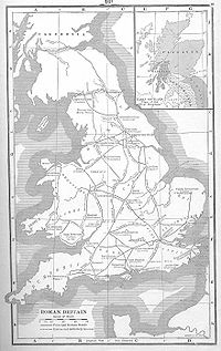
The Roman roads were a vital part of the development of the Roman state, from about 500 BC through the expansion during the Roman Republic and the Roman Empire. Roman roads enabled the Romans to move armies and trade goods and to communicate. The Roman road system spanned more than 400,000 km...
in Britain
Great Britain
Great Britain or Britain is an island situated to the northwest of Continental Europe. It is the ninth largest island in the world, and the largest European island, as well as the largest of the British Isles...
that runs from the Fosse Way
Fosse Way
The Fosse Way was a Roman road in England that linked Exeter in South West England to Lincoln in Lincolnshire, via Ilchester , Bath , Cirencester and Leicester .It joined Akeman Street and Ermin Way at Cirencester, crossed Watling Street at Venonis south...
at Bourton on the Water in Gloucestershire
Gloucestershire
Gloucestershire is a county in South West England. The county comprises part of the Cotswold Hills, part of the flat fertile valley of the River Severn, and the entire Forest of Dean....
(51.888°N 1.767°W) to Templeborough
Templeborough
Templeborough is a suburb of Rotherham, South Yorkshire, England. The area takes its name from the remains of the Roman fort found there which were mistakenly believed to be that of a Roman Temple.-Roman fort:...
in South Yorkshire
South Yorkshire
South Yorkshire is a metropolitan county in the Yorkshire and the Humber region of England. It has a population of 1.29 million. It consists of four metropolitan boroughs: Barnsley, Doncaster, Rotherham, and City of Sheffield...
(53.418°N 1.394°W). It passes through Alcester
Alcester
Alcester is an old market town of Roman origin at the junction of the River Alne and River Arrow in Warwickshire, England. It is situated approximately west of Stratford-upon-Avon, and 8 miles south of Redditch, close to the Worcestershire border...
, Studley
Studley
Studley is a large village and civil parish in the Stratford-on-Avon district of Warwickshire, England. Situated on the western edge of Warwickshire near the border with Worcestershire it is southeast of Redditch and northwest of Stratford. The Roman road of Ryknild Street, now the A435, passes...
, Redditch
Redditch
Redditch is a town and local government district in north-east Worcestershire, England, approximately south of Birmingham. The district had a population of 79,216 in 2005. In the 19th century it became the international centre for the needle and fishing tackle industry...
, Metchley Fort
Metchley Fort
Metchley Fort was a Roman fort in what is now Birmingham, England.It lies on the course of a Roman road, Icknield Street, which is now the site of the present Queen Elizabeth Hospital and the University of Birmingham in Edgbaston. The fort was constructed soon after the Roman invasion of Britain in...
, Birmingham
Birmingham
Birmingham is a city and metropolitan borough in the West Midlands of England. It is the most populous British city outside the capital London, with a population of 1,036,900 , and lies at the heart of the West Midlands conurbation, the second most populous urban area in the United Kingdom with a...
, Lichfield
Lichfield
Lichfield is a cathedral city, civil parish and district in Staffordshire, England. One of eight civil parishes with city status in England, Lichfield is situated roughly north of Birmingham...
and Derby
Derby
Derby , is a city and unitary authority in the East Midlands region of England. It lies upon the banks of the River Derwent and is located in the south of the ceremonial county of Derbyshire. In the 2001 census, the population of the city was 233,700, whilst that of the Derby Urban Area was 229,407...
.
Names
Leges Edwardi Confessoris
The title Leges Edwardi Confessoris "Laws of Edward the Confessor" refers to an early twelfth-century English collection of 39 laws .-Historical value:The text’s own promises are both false and misleading...
; Watling Street
Watling Street
Watling Street is the name given to an ancient trackway in England and Wales that was first used by the Britons mainly between the modern cities of Canterbury and St Albans. The Romans later paved the route, part of which is identified on the Antonine Itinerary as Iter III: "Item a Londinio ad...
, Ermine Street
Ermine Street
Ermine Street is the name of a major Roman road in England that ran from London to Lincoln and York . The Old English name was 'Earninga Straete' , named after a tribe called the Earningas, who inhabited a district later known as Armingford Hundred, around Arrington, Cambridgeshire and Royston,...
, the Fosse Way and Hikenild or Icknield Street. Hikenild Strete, is generally supposed to be connected with the country of the Iceni
Iceni
The Iceni or Eceni were a British tribe who inhabited an area of East Anglia corresponding roughly to the modern-day county of Norfolk between the 1st century BC and the 1st century AD...
. Various forms of the name, the earliest in Anglo-Saxon charters are Icenhilde Weg or Icenilde Weg, designate roads from the borders of Norfolk through Cambridgeshire, Bucks, Berks, Hants, and Wilts into Dorset. These locations however would identify the route as Icknield Way
Icknield Way
The Icknield Way is an ancient trackway in southern England. It follows the chalk escarpment that includes the Berkshire Downs and Chiltern Hills.-Background:...
an Iron Age
Iron Age
The Iron Age is the archaeological period generally occurring after the Bronze Age, marked by the prevalent use of iron. The early period of the age is characterized by the widespread use of iron or steel. The adoption of such material coincided with other changes in society, including differing...
trackway running from Norfolk
Norfolk
Norfolk is a low-lying county in the East of England. It has borders with Lincolnshire to the west, Cambridgeshire to the west and southwest and Suffolk to the south. Its northern and eastern boundaries are the North Sea coast and to the north-west the county is bordered by The Wash. The county...
to Dorset
Dorset
Dorset , is a county in South West England on the English Channel coast. The county town is Dorchester which is situated in the south. The Hampshire towns of Bournemouth and Christchurch joined the county with the reorganisation of local government in 1974...
. The road acquired the name Ryknild Street during the 12th century when it was named by Ranulf Higdon
Ranulf Higdon
Ranulf Higden was an English chronicler and a Benedictine monk of the monastery of St. Werburgh in Chester....
, a monk of Chester writing in 1344 in his Polychronicon. Higdon, gives the name of the fourth road as Rikenild Strete, which, he says, tends from the south-west to the north, and begins at St. David's and continues to the mouth of the Tyne, passing Worcester, Droitwich, Birmingham, Lichfield, Derby, and Chesterfield. It has borne that name, or Rigning, Reenald, or Rignall, from early times. In three of the four MSS. of Higdon, the name is given Rikenilde, Rikenyldes, and in the fourth, which is said to be one of the earliest, Hikenil Street. Trevisa's English translation (1387) calls it Rykeneldes Strete. Harverfield writing in the Victoria County History
Victoria County History
The Victoria History of the Counties of England, commonly known as the Victoria County History or the VCH, is an English history project which began in 1899 and was dedicated to Queen Victoria with the aim of creating an encyclopaedic history of each of the historic counties of...
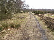
of Warwickshire doubted whether the road had any real and original right to either name, preferring Ryknild as no less correct, (or no more incorrect) and being able to distinguish it from Icknield Street in Oxfordshire and Berkshire. It is now called Icknield or Ryknild Street to distinguish it from the older Icknield Way. A preserved section of the Roman road can be seen at Sutton Park
Sutton Park
Sutton Park, in Sutton Coldfield, Birmingham, England, is one of the largest urban parks in Europe and the largest outside a capital city; it is larger than Richmond Park in London....
in Birmingham
Birmingham
Birmingham is a city and metropolitan borough in the West Midlands of England. It is the most populous British city outside the capital London, with a population of 1,036,900 , and lies at the heart of the West Midlands conurbation, the second most populous urban area in the United Kingdom with a...
.
Today's Route
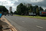
Much of the route of the Icknield Street is used by modern roads, most notably the A38A38 road
The A38, part of which is also known as the Devon Expressway, is a major A-class trunk road in England.The road runs from Bodmin in Cornwall to Mansfield in Nottinghamshire. It is long, making it one of the longest A-roads in England. It was formerly known as the Leeds — Exeter Trunk Road,...
from Lichfield to Derby; and many sections retain the name "Icknield Street", but not always accurately as in Hockley
Hockley
Hockley is a large village and civil parish in Essex, England located between Chelmsford and Southend-on-Sea. More specifically it lies between Rayleigh and Rochford. It came to prominence during the coming of the railway in the 1890s and at the 2001 census had a population of 13,616 people, many...
, Birmingham
Birmingham
Birmingham is a city and metropolitan borough in the West Midlands of England. It is the most populous British city outside the capital London, with a population of 1,036,900 , and lies at the heart of the West Midlands conurbation, the second most populous urban area in the United Kingdom with a...
and in Redditch
Redditch
Redditch is a town and local government district in north-east Worcestershire, England, approximately south of Birmingham. The district had a population of 79,216 in 2005. In the 19th century it became the international centre for the needle and fishing tackle industry...
, Worcestershire where there is also a road called Icknield Street Drive which stands near the course of the Roman road. http://maps.google.co.uk/maps?hl=en&q=Icknield%20Street%20Drive&cr=countryUK%7CcountryGB&um=1&ie=UTF-8&sa=N&tab=wl "Ryknild Street" is still in use in Lichfield and "Ryknild Road" in Derby.
Bourton-on-the-Water to Bidford-on-Avon
The road appears to have joined the Fosse Way near Bourton-on‑the‑Water. Starting about two miles north of there, and two miles west of Stow-on-the-WoldStow-on-the-Wold
Stow-on-the-Wold is a market town and civil parish in Gloucestershire, England. It is situated on top of an 800 ft hill, at the convergence of a number of major roads through the Cotswolds, including the Fosse Way . The town was founded as a planned market place by Norman lords to take...
, a lane (Condicott Lane) runs northwards in a straight line to Condicote
Condicote
Condicote is a small village in Gloucestershire, England. It is near the A424 road. It has a small church dedicated to St Nicholas.-External links:**...
and then Hinchwick
Hinchwick
Hinchwick is a small village in Gloucestershire, England at .Hinchwick Manor was built by architect Charles Robert Cockerell in 1826.-References:...
. This lane appears to indicate the course of Icknield Street. It leads towards high ground, about 840 feet (256 m) on Bourton Down. It is not clear how the ascent of 250 feet (76.2 m) from Hinchwick to the Down was made, but on the Down a lane northwards from Springhill takes nearly the same line for 1.5 miles (2.4 km) to near the Evesham
Evesham
Evesham is a market town and a civil parish in the Local Authority District of Wychavon in the county of Worcestershire, England with a population of 22,000. It is located roughly equidistant between Worcester, Cheltenham and Stratford-upon-Avon...
road 950 feet (289.6 m), from which a parish boundary over Saintbury Hill seems to mark the course down the north side. On the west side of Weston Park, a line seems to be taken up lying between high ground 940 feet (286.5 m), 2 miles (3.2 km) to the south, and Alcester, 12 miles (19.3 km) to the north. A road in this line, passing on the west of Weston-sub‑Edge, leads on to a highway with a parish boundary along it called Riknild or Icknield Street, which is crossed by the railway at Honeybourne Station
Honeybourne railway station
Honeybourne railway station serves the village of Honeybourne in Worcestershire, England. It is on the Cotswold Line and was formerly a junction with four platforms.-History:...
. It continues northward under the name of Buckle Street to Staple Hill, one mile south of Bidford-on-Avon
Bidford-on-Avon
Bidford-on-Avon is a large village and civil parish in the English county of Warwickshire. In the 2001 census it had a population of 4,830.-Location:...
. This is probably the oldest version of the name being the modern form of a name Bucgan or Buggilde Street which appears in documents earlier than the Norman Conquest
Norman conquest of England
The Norman conquest of England began on 28 September 1066 with the invasion of England by William, Duke of Normandy. William became known as William the Conqueror after his victory at the Battle of Hastings on 14 October 1066, defeating King Harold II of England...
. As the road approaches Bidford there is a slight turn, and the modern road heads for the crossing point of the medieval bridge whereas the Roman ford is upstream of here and the road name preserved in a small road named Icknield Street on the northern bank. Evidence of a Roman causeway here confirms this as the Roman crossing point.
Bidford-on-Avon to Birmingham
From Bidford following the named Icknield Street the line of the road ten follows Waterloo Street through Bidford and then across country as the B4085. At WixfordWixford
Wixford is a hamlet and civil parish in the Stratford district of Warwickshire, England, situated south of Alcester. The name derives from a compound of the Old English personal name Whitlac with the noun for a river crossing "ford"...
by the Three Horse Shoes Inn the modern road turns west whilst the line of the road continues north in a hollow way to Saint Milburga's church where it becomes a track running along the ridge to the east of Ragley Hall
Ragley Hall
Ragley Hall is located south of Alcester, Warwickshire, eight miles west of Stratford-upon-Avon. It is the ancestral seat of the Marquess of Hertford and is one of the stately homes of England.-The present day:...
heading towards Alcester. At Alcester the original crossing point has been lost due to changes in the course of the river and the development of the town but the line is recovered north of the town on the modern A435. Passing Coughton Court
Coughton Court
Coughton Court is an English Tudor country house, situated on the main road between Studley and Alcester in Warwickshire. It is a Grade I listed building....
the road bears the local name of Headon or Haydon Way and proceeds though Studley
Studley
Studley is a large village and civil parish in the Stratford-on-Avon district of Warwickshire, England. Situated on the western edge of Warwickshire near the border with Worcestershire it is southeast of Redditch and northwest of Stratford. The Roman road of Ryknild Street, now the A435, passes...
and to one mile beyond, where the modern road turns off to the north-eastward. Heading north much of the route is lost, since Codrington wrote, in the development of Redditch, however Icknield Street Drive, Battens Drive approximates the route until a small road through the residential area of Churchill marked Ryknield Street on the modern 1:25,000 Ordnance Survey map, exactly in a line with Haydon Way, is reached. This line appears to point from Alcester to high ground about 480 feet (146.3 m), one mile east of Rowney Green
Rowney Green
Rowney Green is a village in Worcestershire, England. It recently received a grant from the National Lottery, in association with Central News, to refurbish the village hall's roof. Famous inhabitants of Rowney Green include ex-England test cricketer Gladstone Small....
, and 1.5 miles (2.4 km) north of Beoley
Beoley
Beoley is a village and civil parish just north of Redditch in the Bromsgrove District of Worcestershire, and adjoins Warwickshire to the east. The 2001 census recorded a parish population of 945, most of whom live at Holt End...
. Now the B4497 the road heads north through Beoley crossing over the M42 motorway
M42 motorway
The M42 motorway is a major road in England. The motorway runs north east from Bromsgrove in Worcestershire to just south west of Ashby-de-la-Zouch in Leicestershire, passing Redditch, Solihull, the National Exhibition Centre and Tamworth on the way. The section between the M40 and M6 road forms...
just south of Alcott Farm. It retains the name Icknield Street, climbing the high ground of Swans Hill between the Coach and Horses Public House at Weatheroak and the Peacock Inn at the junction with Lea End Lane. Here, a hedge line and footpath run directly up the hill while the modern road deviates slightly to the east to accommodate the incline before rejoining the original route and continuing north until it enters the suburbs of Birmingham
Birmingham
Birmingham is a city and metropolitan borough in the West Midlands of England. It is the most populous British city outside the capital London, with a population of 1,036,900 , and lies at the heart of the West Midlands conurbation, the second most populous urban area in the United Kingdom with a...
at Kings Norton
Kings Norton
Kings Norton is an area of Birmingham, England. It is also a Birmingham City Council ward within the formal district of Northfield.-History:...
adjacent to the Romano British settlement of Longdales Road. It then follows the course of Walkers Heath Road over the traffic roundabout at Parsons Hill, to Broadmeadow Lane, Lifford Lane, Pershore Road and Hazelwell Street, finally disappearing into residential developments at Stirchley
Stirchley, West Midlands
Stirchley is a southern area of Birmingham, England. Close to the districts of Kings Heath, Bournville, Selly Park, Cotteridge and King's Norton...
by the swimming baths.
Across Birmingham
Queen Elizabeth Hospital Birmingham
The Queen Elizabeth Hospital Birmingham is an NHS hospital in the Edgbaston area of Birmingham, situated very close to the University of Birmingham. The hospital, which cost £545 million to construct, opened in June 2010 replacing the previous Queen Elizabeth Hospital and Selly Oak Hospital...
. The fort was established about 48 AD by the Roman army
Roman army
The Roman army is the generic term for the terrestrial armed forces deployed by the kingdom of Rome , the Roman Republic , the Roman Empire and its successor, the Byzantine empire...
as a base camp for its conquest of the Birmingham area and part of a network of forts across the Midlands linked by roads. It stood by Birmingham's earliest known road junction at the point where Icknield Street was met by Roman roads coming in from Droitwich
Droitwich Spa
Droitwich Spa is a town in northern Worcestershire, England, on the River Salwarpe.The town is situated on massive deposits of salt, and salt has been extracted there since ancient times. The natural Droitwich brine contains 2½ lbs...
and Penkridge
Penkridge
Penkridge is a market town and ancient parish in Staffordshire, England with a population of 7,836 . Many locals refer to it as a village, although it has a long history as an ecclesiastical and commercial centre. Its main distinction in the Middle Ages was as the site of an important collegiate...
. From here the road runs north to another fort at Wall, Roman Etocetum
Letocetum
Letocetum is the remains of a Roman settlement. It was an important military staging post and posting station near the junction of Watling Street, the Roman military road to North Wales , and Icknield Street . The site is now within the parish of Wall, Staffordshire, England...
near Lichfield. The Perry Bridge
Perry Bridge
Perry Bridge, also known as the Zig Zag Bridge, is a bridge over the River Tame in Perry Barr, Birmingham, England. Built in 1711, it is said to be the oldest surviving structure in Birmingham. It is a scheduled ancient monument and a Grade II listed building.The bridge was built, in the 18th...
of 1711 stands at its crossing of the River Tame in Perry Barr
Perry Barr
Perry Barr is an inner-city area in north Birmingham, England. It is also a council constituency, managed by its own district committee. The constituency includes the smaller Perry Barr ward and the wards of Handsworth Wood, Lozells and East Handsworth, and Oscott, which elect three councillors to...
. However, Walker cast doubts on this orthodox view of the road's course in this area and resistivity surveys undertaken on sites either side of the crossing in 1992, showed that, although the line of the road is clearly indicated on old maps and aerial photographs, the site has been considerably altered this century by, among other things, the embankment of the M6
M6 motorway
The M6 motorway runs from junction 19 of the M1 at the Catthorpe Interchange, near Rugby via Birmingham then heads north, passing Stoke-on-Trent, Manchester, Preston, Carlisle and terminating at the Gretna junction . Here, just short of the Scottish border it becomes the A74 which continues to...
. The one place where the road might have been detected proved inaccessible without considerable clearance of dense undergrowth (remnants of a hedge-line following the road?) and a 20 metre grid on adjacent open ground proved negative. The second site was on wasteland immediately south of the river. Here, the "Walker" road-line only shaved the top comer of this before disappearing under a modern industrial development (plot-holders in allotments to the south did not recall any finds during building work, nor were they able to identify any "hard" areas on their land, where the "Walker" line might be expected to continue). A series of complete and partial 20 metre grids laid down the fence line between the industrial estate and the wasteland and then right across the open area yielded nothing which could relate to the "Walker" line but did produce some low resistance features running parallel with the site's east boundary.
Birmingham to Lichfield
From Perry Bridge the road heads North, Coddrington describes the route as following a county boundary for a quarter of a mile and then a road, now the B4138, Kingstanding Road, until it enters Sutton Park close to the old Royal Oak Inn, now the Toby Carvery and Lodge.http://www.tobycarvery.co.uk/streetlysuttoncoldfield/ The course is preserved as it crosses the Western edge of the park, where the ridge appears very plainly, of a rounded profile, eight or nine yards wide over all, and three to four feet high in the middle. It has been described as presenting one of the best examples of a Roman road, 60 feet (18.3 m) wide with a ditch on each side. It has little claim to be so considered, and the ditches where they occur appear to be connected with modern drainage. To the north of the park, about half-a‑mile through the private residential estate Little Aston ParkLittle Aston Park
Little Aston Park is a private residential estate, ranked in the most expensive areas in England and Wales, set in a woodland setting, located approximately seven miles north of Birmingham in Little Aston...
where it is named Roman Road, a short length of road north of Little Aston, Forge Lane, and another length to the west of Shenstone, mark the course of the road in a straight line from Streetley Hill to high ground 450 feet (137.2 m), on the north-east of Wall. From near Birmingham to Wall (Etocetum) for nine miles the road is not perceptibly out of a straight line, which may very well have been set out from intermediate points at Streetley Hill, and the high ground 500 feet (152.4 m), south of the old Royal Oak Inn. Icknield Street would appear to have crossed Watling Street on the east of Etocetum at the point where Ashcroft Lane crosses the A5. There is then a considerable change of direction to the north-east, and a straight course for nine miles to near Barton-under-Needwood. The alignment was sighted from Knowle Farm, as there is a slight bend at this point. Knowle Lane then follows the course of the old road leading into Cricket Lane, Quarry Hills Lane and on to a presevation of the name as Ryknild Strreet. This in turn leads to Austin Cote Lane, which crosses the Brittania Enterprise Park onto the Old Burton Road, joining the A38 at Streethay.
Lichfield to Derby
The old road is still used, save a few local diversions, from the crossing with the main Birmingham-Lichfield road (A 38(T), to Littleover on the outskirts of Derby and here the highway is very straight and well raised, by two to three feet in places, a fine example of a Roman road still in use. William StukeleyWilliam Stukeley
William Stukeley FRS, FRCP, FSA was an English antiquarian who pioneered the archaeological investigation of the prehistoric monuments of Stonehenge and Avebury, work for which he has been remembered as "probably... the most important of the early forerunners of the discipline of archaeology"...
wrote that "part of Rigning Way north from Wall was very fair with a high straight bank" and that "upon the hill south of Littleover, Rigning is under the eye as far as Etocetum, and the hills beyond it." At Littleover the road turns to the east as the modern A5250, but named Rykneld Street and later Pastures Hill where a section of road has been examined adjacent to Derby High School and Pineview Gardens, 4 km south west of Derventio
Derventio (Little Chester)
Derventio was a small town in the Roman province of Britannia. Today it is known as Little Chester, on the outskirts of Derby, located in the English county of Derbyshire.-Description:...
, the Roman fort at Little Chester. The buried remains of the Roman road are not visible above ground but include drainage features and construction pits flanked by shallow boundary ditches. Plough scars cutting the Roman road surface indicate that in the post-Roman period the site was used for arable land whilst in the 18th century, it formed part of the Birmingham to Derby turnpike
Turnpike trust
Turnpike trusts in the United Kingdom were bodies set up by individual Acts of Parliament, with powers to collect road tolls for maintaining the principal highways in Britain from the 17th but especially during the 18th and 19th centuries...
but it is also possible that by this time, the main road had been diverted onto its present course at Pastures Hill. Archaeological excavation in 2003 by the Birmingham University Field Archaeology Unit identified the presence of a Bronze Age
Bronze Age
The Bronze Age is a period characterized by the use of copper and its alloy bronze as the chief hard materials in the manufacture of some implements and weapons. Chronologically, it stands between the Stone Age and Iron Age...
cremation cemetery in the area between the road and Pastures Hill. A Bronze age cremation urn was recovered as well as evidence for Iron Age
Iron Age
The Iron Age is the archaeological period generally occurring after the Bronze Age, marked by the prevalent use of iron. The early period of the age is characterized by the widespread use of iron or steel. The adoption of such material coincided with other changes in society, including differing...
occupation indicating the area may have served as a long lived ritual landscape, including Bronze Age to Roman activity in the Roman road’s alignment. It has been suggested that the Bronze Age cremations could have been laid out along the line of a Bronze Age trackway which continued to use into, or was returned to use, during the Roman period.
The course appears to have been on the west side of Derby passing close to a Roman fort, occupied in 50 AD, at Strutts Park (some finds of pottery from the excavations of the fort are in the collection of Derby Museum
Derby Museum and Art Gallery
Derby Museum and Art Gallery was established in 1879, along with Derby Central Library, in a new building designed by Richard Knill Freeman and given to Derby by Michael Thomas Bass. The collection includes a whole gallery displaying the paintings of Joseph Wright of Derby; there is also a large...
). Swan doubts that Ryknild Street went to Strutts Park, which was replaced around 80 AD by the fort at Chester Green on the other side of the River Derwent
River Derwent, Derbyshire
The Derwent is a river in the county of Derbyshire, England. It is 66 miles long and is a tributary of the River Trent which it joins south of Derby. For half its course, the river flows through the Peak District....
, the construction of Ryknild Street being contemporary with that of the later fort. Stukeley traced the track of the wall at Chester Green all round enclosing an area, according to his plan, 120 paces from east to west, and 100 paces from north to south, the foundation of the bridge he said could be felt with a staff. and Bishop Bennet
William Bennet (bishop)
William Bennet was Bishop of Cloyne, Ireland, and an antiquary. He was born in the Tower of London and educated at Harrow School and Emmanuel College, Cambridge, where he was senior tutor for many years...
in 1817 said that the piers of the bridge could be felt in a dry summer.
Derby to Chesterfield
From Little Chester to the countryside north of Derby, the route has not been determined. It is certain that a road left Derventio to the east which led to Sawley on the River TrentRiver Trent
The River Trent is one of the major rivers of England. Its source is in Staffordshire on the southern edge of Biddulph Moor. It flows through the Midlands until it joins the River Ouse at Trent Falls to form the Humber Estuary, which empties into the North Sea below Hull and Immingham.The Trent...
, Icknield Street branching from this to the North East. The course is well marked beyond Breadsall, one and a half miles from Little Chester, but the intervening length has not yet been ascertained.
External links
- Birmingham Roman Roads Project (Hosted by the University of Birmingham)
- Metchley Fort, Birmingham
- Derby City Council list of Scheduled Ancient Monuments
- Full text of Roman Roads in Britain, Thomas Codrington