
Roman roads in Britain
Encyclopedia
Roman roads, together with Roman aqueduct
s and the vast standing Roman army
(in the 2nd century, ca.
30 legions
plus around 400 auxiliary units
, totalling ca. 400,000 troops, of which ca. 50,000 deployed in Britain), constituted the three most impressive features of the Roman Empire
. In Britain, as in other provinces, the Romans constructed a comprehensive network of paved trunk road
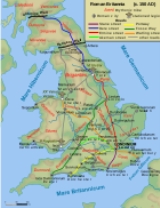
s (i.e. surfaced highways) during their nearly four centuries of occupation (43 - 410 AD). This article focuses on the ca. 2000 mi (3,218.7 km) of Roman roads in Britain shown on the Ordnance Survey
's Map of Roman Britain. This contains the most accurate and up-to-date layout of certain and probable routes that is readily available to the general public.
The pre-Roman Britons
used mostly unpaved trackway
s for their communications, including very ancient ones running along elevated ridges of hills, such as the South Downs Way
, now a public long-distance footpath. By the first century BC, they had begun engineering roads. After the Roman invasion, the road network was expanded. Roman roads were surveyed and built from scratch, with the aim of connecting key points by the most direct possible route. The roads were all paved, to permit even heavy freight-wagons to be used in all seasons and weather.
Most of the known network was complete by 180 AD. Its primary function was to allow the rapid movement of troops and military supplies, but it also provided vital infrastructure for trade and the transport of goods.
Roman roads remained in use as core trunk roads for centuries after the Romans withdrew from Britain in 410 AD. Systematic construction of paved highways did not resume in England until the 18th century.
(Britannia
) to London
(Londinium), the city founded on a virgin site by the Romans, which soon became the province's capital and largest city. The most important trunk roads were those that linked London with (a) the key ports: Dover
(Dubris
), Chichester
(Noviomagus
) and Portchester
(Portus Adurni
); and (b) the main Roman army bases: the three permanent fortresses housing the legions (castra legionaria): York
(Eboracum
), base of the Ninth Legion: Legio IX Hispana
, later the Sixth: Legio VI Victrix
; Chester
(Deva
), base of the Twentieth: Legio XX Valeria Victrix
; and Caerleon
(Isca Augusta
), base of the Second: Legio II Augusta
.
From Chester and York, two key roads led to Hadrian's Wall
, for most of the period Britannia 's northern border, where most of the three legions' auxiliary units were deployed.
From London, six core routes radiated. Ignoring their later Anglo-Saxon
nomenclature (see note to Saxon names of Roman roads below), they are as follows:
The initial road network was built by the army to facilitate military communications. The emphasis was therefore on linking up army bases, rather than catering for economic flows. Thus, three important cross-routes were established early (by 80 AD) as the frontier of the Roman-occupied zone advanced:
Later a large number of other cross-routes and branches were grafted onto this basic grid.
 The earliest roads, built in the first phase of Roman occupation (the Julio-Claudian
period 43–68), connected London with the ports used in the invasion (Chichester and Richborough
), and with the earlier legionary bases at Colchester, Lincoln (Lindum), Wroxeter (Viroconium), Gloucester and Exeter. The Fosse Way, from Exeter to Lincoln, was also built at this time to connect these bases with each other, marking the effective boundary of the early Roman province.
During the Flavian
period (69-96), the roads to Lincoln, Wroxeter and Gloucester were extended (by 80) to the new (and definitive) legionary bases at York, Chester and Caerleon respectively. By 96 further extensions from York to Corbridge, and from Chester to Carlisle and Caernarfon
(Segontium
), were completed as Roman rule was extended over Wales
(Cambria
) and northern England (Brigantia
). Stanegate
, the military road from Carlisle to Corbridge, was built under the Emperor Trajan
(ruled 98-117 AD) along the line of the future Hadrian's Wall, which was constructed by his successor Hadrian
in 122-132 AD.
Scotland
(Caledonia
), including England
north of Hadrian's Wall, remained mostly outside the boundaries of Britannia province, as the Romans never succeeded in subjugating the entire island, despite a serious effort to do so by governor Gnaeus Julius Agricola
in 82-4. However, the Romans maintained a system of forts in the lowland region ca. 80-220 to control the indigenous population beyond Hadrian's Wall and annexed the Lowlands
briefly with the construction of the Antonine Wall
in 164. This barrier, across the 'neck' of Scotland, from the Firth of Clyde
to the Firth of Forth
, was held for some twenty years.
 The Romans' main routes from Hadrian's Wall to the Antonine Wall, built by ca. 120 AD, were: (1) Corbridge to the Roman fort
at Edinburgh
(certain) and (likely) to Carriden
(Veluniate) on the eastern end of the Antonine Wall, via High Rochester
(Bremenium
) and Galashiels
(Trimontium); (2) Carlisle to Bothwellhaugh
(certain) and (likely) to the Antonine.
There was also a certain road beyond the Antonine Wall to Perth
(Bertha
) from the Antonine fort at Falkirk
. Indeed it has been thought that the Roman road to the north of the Forth
, to Stirling
and Perth, dates from the expedition of Severus
to beyond the Dee
, AD 209; it may, however, be doubted if there was time in that campaign for such a work, and the road may well belong to a period before the construction of the Wall of Antonine, AD 140.
The core network was complemented by a number of routes built primarily for commercial, rather than military, purposes.
Examples include: in Kent
and Sussex
, three certain roads leading from London to the important iron-mining area of the Weald
; and in East Anglia
, the road from Colchester to Norwich, Peddars Way
and the Fen Causeway
. However, these Anglian and southern routes acquired military importance from the 3rd century onwards with the emergence of Saxon seaborne raiding as a major and persistent threat to the security of Britannia. These roads linked to the coastal defensive line of Saxon Shore
forts e.g. Brancaster
(Branodunum
), Burgh Castle
(Gariannonum
) near Great Yarmouth
, Lympne
(Portus Lemanis
) and Pevensey (Anderitum
).
 Standard Roman road construction techniques, long evolved on the Continent
, were used. A road occupied a wide strip of land bounded by shallow ditches, varying in width from 86 pedes (25.5 m or 83.7 ft) on Ermin Street
in Berkshire
to 338 pedes (100 m or 328.1 ft) on Akerman Street in Oxfordshire
. A trunk road in Britain would typically be 5 metre in width, with a gauge of 7 m (23 ft) being the most common. [Watling Street was 10.1 m (33.1 ft) wide while the Fosse Way was little more than half that. Several unnamed roads were wider than Watling Street
, such as the Silchester to Chichester road at 11.2 m (36.7 ft).
In the centre a carriageway
was built on a raised agger after stripping off soft topsoil, using the best local materials, often sand or sandy gravel. The two strips of ground between the agger and the boundary ditches were used by pedestrians and animals, and were sometimes lightly metalled. The agger was sometimes, but not always, bordered by deep ditches to take rainwater and keep the road structure as dry as possible.
The metalling was in two layers, a foundation of medium- to large- stone covered by a running surface, often a compacted mixture of smaller flint and gravel. About one quarter of road pavements were "bottomed" with large stones, mostly in the north and west where stone was more readily available. Some high-status roads in Italy
were bound together by volcanic mortar, and a small minority of excavated sites in Britain have shown concrete or limestone mortar. Road surfaces in the iron-producing areas of the Weald were made from iron slag
. The average depth of metalling over 213 recorded roads is about 51 cm (20.1 in), with great variation from as little as 10 cm (3.9 in) to 3 or in places, probably built up over centuries.
The main trunk roads were originally constructed by the Roman army. Responsibility for their regular repair and maintenance rested with designated imperial officials (the curatores viarum), though the cost would probably have been borne by the local civitas
(county) authorities whose territory the road crossed. From time to time, the roads would be completely resurfaced and might even be entirely rebuilt, e.g. the complete reconstruction and widening of the Via Aemilia
in northern Italy by the Emperor Augustus
(r.37 BC- 14 AD), two centuries after it was first built.
 Extant remains of Roman roads are often much degraded or contaminated by later surfacing. Well-preserved sections of Roman road include Wade's Causeway
in Yorkshire
, and at Blackpool Bridge in the Forest of Dean
, although their integrity as original Roman surfaces is not certain. In many places, Roman roads were built over in the 18th century to create the turnpikes
. Where they have not been built over, many sections have been ploughed over by farmers and some stripped of their stone to use on turnpike roads. However, there are numerous tracts of Roman road which have survived, albeit overgrown by vegetation, in the visible form of footpaths through woodland or common land. e.g. the section of Stane Street crossing Eartham Wood in the South Downs
near Bignor
(Sussex). This and others like it are marked on Ordnance Survey maps with dotted lines and the rubric "ROMAN ROAD". Peddars Way in Norfolk
is a Roman road converted into a long-distance footpath.
Wayside stations have been identified in Britain. Roman roads had regularly spaced stations along their length - the Roman equivalent of motorway service area
s. Roughly every 4 mi (6.4 km) - the most a horse could safely be ridden hard - there would be a mutatio (literally: "a change"), essentially stables where mounted messengers could change horses and a tavern to obtain refreshment. Cavalrymen from auxiliary
mixed infantry- and cavalry- regiments (cohortes equitatae
) provided most of the army's despatch-riders (dispositi). Relays of fresh riders and horses careering at full gallop could sustain an average speed of about 20 mph (8.9 m/s). Thus an urgent despatch from the army base at York to London - 200 mi (321.9 km), a journey of over a week for a normal mounted traveller - could be delivered in just 10 hours. Because mutationes were relatively small establishments, and their remains ambiguous, it is difficult to identify sites with certainty.
Approximately every 12 mi (19.3 km) - a typical day's journey for an ox-drawn wagon - was a mansio
(literally: "a sojourn", from which derive the English word "mansion" and French maison or "house"). This was a full-scale wayside inn, with large stables, tavern, rooms for travellers and even bath-houses
in the larger establishments. Mansiones also housed detachments of troops, primarily auxiliaries, which regularly garrisoned and patrolled the roads along their whole length. These would check the identities, travel permits and cargoes of road users. Mansiones may also have housed the agents of the imperial procurator
(the chief financial officer in the province) who collected the portorium, an imperial toll on goods in transit on public roads that was charged at 2% - 2.5% of the value. The tax would be exacted when the goods crossed fixed toll points along the roads, which likely were located in or near mansiones. At least half a dozen sites have been positively identified as mansiones in Britain. e.g. the excavated mansio at Godmanchester
(Durovigutum) on Ermine Street
(near Huntingdon
, Cambridgeshire
).
Mutationes and mansiones were the key infrastructure for the cursus publicus
(the imperial postal and transport system), which operated in many provinces of the Roman Empire. The cursus was primarily concerned with the carriage of government or military officers, government payload such as monies from tax collection and for military wages, and official despatches, but it could be made available to private individuals with special permission and for a fee. In Britain, the Vindolanda tablets
, a series of letters written on wooden tablets to and by members of the garrison of Hadrian's Wall, show the operation of the cursus on the island.
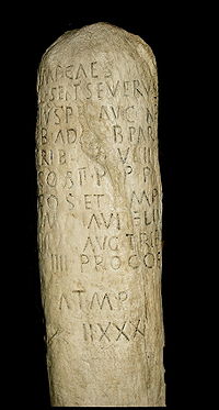
Milestone
s, of which 95 are recorded in Roman Inscriptions of Britain. Most of these date from the later part of the Roman period (250 AD onwards), since it was the practice to replace a road's milestones when a major repair was carried out. Milestones were usually cylindrical and 2 metre in height. Most contain only the customary dedication to the current Emperor and the number of miles to a particular destination. Only three provide additional information: two are dedicated by the public works departments of a civitas (county) (Dobunni
) and a city (Lincoln), showing the involvement of local authorities in road maintenance; and the third records that the Emperor Caracalla
(r. 211-217) "restored the roads, which had fallen into ruin and disuse through old age".
Maps and Itineraries of the Roman era, designed to aid travellers, provide useful evidence of placenames, routes and distances in Britain. The most important is the Antonine Itinerary
, dating from the later 3rd century, which contains 14 itineraries on the island.
 In some places, the origins of the roads were forgotten and they were ascribed to mythical Anglo-Saxon giants and divinities: for instance, Wade's Causeway in North Yorkshire
owes its name to Wōden
, the supreme god of Germanic
and Norse mythology
. Chaucer's
pilgrims in The Canterbury Tales
almost certainly used Watling Street to travel from Southwark
to Canterbury.
Many modern roads still overlie Roman roads. Much of Watling Street, for example, is now under the A2
and A5.
Many English placenames derive from a position on or near a Roman road, usually denoted by the element -street (also strat-, strait-, streat- and other variants). Thus, for example, Stretham
means "homestead or village on a Roman road" and likewise Stretford
means "ford
on a Roman road". There are seventeen places in England named Stretton
, of which all but two are evidently located on a Roman road.
(the "Dark Ages"). The English classification of a particular road does not correspond to the likely original Roman name e.g. the Anglo-Saxons gave the name Watling Street to the entire route from Dover to Wroxeter, via London. But the Romans may well have regarded the first section - Dover to London - as a separate road with a different name from the second section - London to Wroxeter.
The only Anglo-Saxon name which may echo an original Roman name is the Fosse Way - Exeter to Lincoln. Even then it is likely to derive from a popular, rather than official, Roman name for the road. "Fosse" may derive from the Latin fossa, meaning "ditch". But, officially, a road would normally be named after the Emperor in whose reign it was completed, e.g. the Via Traiana
from Rome
to Brindisi
in southern Italy, named after the Emperor Trajan (r.98-117 AD). Thus the Dover to London section of Watling Street may have been known to the Romano-Britons as the Via Claudia after the Emperor Claudius
(r.41-54 AD), who was responsible for the Roman invasion of Britain
in 43 AD.
Roman aqueduct
The Romans constructed numerous aqueducts to serve any large city in their empire, as well as many small towns and industrial sites. The city of Rome had the largest concentration of aqueducts, with water being supplied by eleven aqueducts constructed over a period of about 500 years...
s and the vast standing Roman army
Roman army
The Roman army is the generic term for the terrestrial armed forces deployed by the kingdom of Rome , the Roman Republic , the Roman Empire and its successor, the Byzantine empire...
(in the 2nd century, ca.
Circa
Circa , usually abbreviated c. or ca. , means "approximately" in the English language, usually referring to a date...
30 legions
Roman legion
A Roman legion normally indicates the basic ancient Roman army unit recruited specifically from Roman citizens. The organization of legions varied greatly over time but they were typically composed of perhaps 5,000 soldiers, divided into maniples and later into "cohorts"...
plus around 400 auxiliary units
Auxiliaries (Roman military)
Auxiliaries formed the standing non-citizen corps of the Roman army of the Principate , alongside the citizen legions...
, totalling ca. 400,000 troops, of which ca. 50,000 deployed in Britain), constituted the three most impressive features of the Roman Empire
Roman Empire
The Roman Empire was the post-Republican period of the ancient Roman civilization, characterised by an autocratic form of government and large territorial holdings in Europe and around the Mediterranean....
. In Britain, as in other provinces, the Romans constructed a comprehensive network of paved trunk road
Trunk road
A trunk road, trunk highway, or strategic road is a major road—usually connecting two or more cities, ports, airports, and other things.—which is the recommended route for long-distance and freight traffic...
s (i.e. surfaced highways) during their nearly four centuries of occupation (43 - 410 AD). This article focuses on the ca. 2000 mi (3,218.7 km) of Roman roads in Britain shown on the Ordnance Survey
Ordnance Survey
Ordnance Survey , an executive agency and non-ministerial government department of the Government of the United Kingdom, is the national mapping agency for Great Britain, producing maps of Great Britain , and one of the world's largest producers of maps.The name reflects its creation together with...
's Map of Roman Britain. This contains the most accurate and up-to-date layout of certain and probable routes that is readily available to the general public.
The pre-Roman Britons
Britons (historical)
The Britons were the Celtic people culturally dominating Great Britain from the Iron Age through the Early Middle Ages. They spoke the Insular Celtic language known as British or Brythonic...
used mostly unpaved trackway
Trackway
A trackway is an ancient route of travel for people or animals. In biology, a trackway can be a set of impressions in the soft earth, usually a set of footprints, left by an animal. A fossil trackway is the fossilized imprint of a trackway. Trackways have been found all over the world...
s for their communications, including very ancient ones running along elevated ridges of hills, such as the South Downs Way
South Downs Way
The South Downs Way is a long distance footpath and bridleway running along the South Downs in southern England, and is one of 15 National Trails in England and Wales...
, now a public long-distance footpath. By the first century BC, they had begun engineering roads. After the Roman invasion, the road network was expanded. Roman roads were surveyed and built from scratch, with the aim of connecting key points by the most direct possible route. The roads were all paved, to permit even heavy freight-wagons to be used in all seasons and weather.
Most of the known network was complete by 180 AD. Its primary function was to allow the rapid movement of troops and military supplies, but it also provided vital infrastructure for trade and the transport of goods.
Roman roads remained in use as core trunk roads for centuries after the Romans withdrew from Britain in 410 AD. Systematic construction of paved highways did not resume in England until the 18th century.
Key routes
The old Roman proverb that "all roads lead to Rome" was largely applicable in Roman BritainRoman Britain
Roman Britain was the part of the island of Great Britain controlled by the Roman Empire from AD 43 until ca. AD 410.The Romans referred to the imperial province as Britannia, which eventually comprised all of the island of Great Britain south of the fluid frontier with Caledonia...
(Britannia
Britannia
Britannia is an ancient term for Great Britain, and also a female personification of the island. The name is Latin, and derives from the Greek form Prettanike or Brettaniai, which originally designated a collection of islands with individual names, including Albion or Great Britain. However, by the...
) to London
London
London is the capital city of :England and the :United Kingdom, the largest metropolitan area in the United Kingdom, and the largest urban zone in the European Union by most measures. Located on the River Thames, London has been a major settlement for two millennia, its history going back to its...
(Londinium), the city founded on a virgin site by the Romans, which soon became the province's capital and largest city. The most important trunk roads were those that linked London with (a) the key ports: Dover
Dover
Dover is a town and major ferry port in the home county of Kent, in South East England. It faces France across the narrowest part of the English Channel, and lies south-east of Canterbury; east of Kent's administrative capital Maidstone; and north-east along the coastline from Dungeness and Hastings...
(Dubris
Dubris
Dubris or Portus Dubris was a town in Roman Britain. It is now Dover, Kent, England.As the closest point to continental Europe and the site of the estuary of the Dour, the site chosen for Dover was ideal for a cross-channel port...
), Chichester
Chichester
Chichester is a cathedral city in West Sussex, within the historic County of Sussex, South-East England. It has a long history as a settlement; its Roman past and its subsequent importance in Anglo-Saxon times are only its beginnings...
(Noviomagus
Noviomagus Reginorum
Noviomagus Reginorum was the Roman town which is today called Chichester, situated in the modern English county of West Sussex. Alternative versions of the name include Noviomagus Regnorum, Regnentium and Regentium..-Development:...
) and Portchester
Portchester
Portchester is a locality and suburb 10km northwest of Portsmouth, England. It is part of the borough of Fareham in Hampshire. Once a small village, Portchester is now a busy part of the expanding conurbation between Portsmouth and Southampton, on the A27 main thoroughfare...
(Portus Adurni
Portus Adurni
Portus Adurni was a Roman fortress in the Roman province of Britannia. Listed in the Notitia Dignitatum, it is generally accepted as having been located at adjoining Portchester in the English county of Hampshire and was later converted into a medieval castle known as Portchester Castle...
); and (b) the main Roman army bases: the three permanent fortresses housing the legions (castra legionaria): York
York
York is a walled city, situated at the confluence of the Rivers Ouse and Foss in North Yorkshire, England. The city has a rich heritage and has provided the backdrop to major political events throughout much of its two millennia of existence...
(Eboracum
Eboracum
Eboracum was a fort and city in Roman Britain. The settlement evolved into York, located in North Yorkshire, England.-Etymology:The first known recorded mention of Eboracum by name is dated circa 95-104 AD and is an address containing the Latin form of the settlement's name, "Eburaci", on a wooden...
), base of the Ninth Legion: Legio IX Hispana
Legio IX Hispana
Legio Nona Hispana was a Roman legion, which operated from the first century BCE until mid 2nd century CE. The Spanish Legion's disappearance has raised speculations over its fate, largely of its alleged destruction in Scotland in about 117 CE, though some scholars believe it was destroyed in the...
, later the Sixth: Legio VI Victrix
Legio VI Victrix
Legio sexta Victrix was a Roman legion founded by Octavian in 41 BC. It was the twin legion of VI Ferrata and perhaps held veterans of that legion, and some soldiers kept to the traditions of the Caesarian legion....
; Chester
Chester
Chester is a city in Cheshire, England. Lying on the River Dee, close to the border with Wales, it is home to 77,040 inhabitants, and is the largest and most populous settlement of the wider unitary authority area of Cheshire West and Chester, which had a population of 328,100 according to the...
(Deva
Deva Victrix
Deva Victrix, or simply Deva, was a legionary fortress and town in the Roman province of Britannia. The settlement evolved into Chester, the county town of Cheshire, England...
), base of the Twentieth: Legio XX Valeria Victrix
Legio XX Valeria Victrix
Legio vigesima Valeria Victrix was a Roman legion, probably raised by Augustus some time after 31 BC. It served in Hispania, Illyricum, and Germania before participating in the invasion of Britannia in 43 AD, where it remained and was active until at least the beginning of the 4th century...
; and Caerleon
Caerleon
Caerleon is a suburban village and community, situated on the River Usk in the northern outskirts of the city of Newport, South Wales. Caerleon is a site of archaeological importance, being the site of a notable Roman legionary fortress, Isca Augusta, and an Iron Age hill fort...
(Isca Augusta
Isca Augusta
Isca Augusta was a Roman legionary fortress and settlement, the remains of which lie beneath parts of the present-day village of Caerleon on the northern outskirts of the city of Newport in South Wales.-Name:...
), base of the Second: Legio II Augusta
Legio II Augusta
Legio secunda Augusta , was a Roman legion, levied by Gaius Vibius Pansa Caetronianus in 43 BC, and still operative in Britannia in the 4th century...
.
From Chester and York, two key roads led to Hadrian's Wall
Hadrian's Wall
Hadrian's Wall was a defensive fortification in Roman Britain. Begun in AD 122, during the rule of emperor Hadrian, it was the first of two fortifications built across Great Britain, the second being the Antonine Wall, lesser known of the two because its physical remains are less evident today.The...
, for most of the period Britannia 's northern border, where most of the three legions' auxiliary units were deployed.
From London, six core routes radiated. Ignoring their later Anglo-Saxon
Anglo-Saxons
Anglo-Saxon is a term used by historians to designate the Germanic tribes who invaded and settled the south and east of Great Britain beginning in the early 5th century AD, and the period from their creation of the English nation to the Norman conquest. The Anglo-Saxon Era denotes the period of...
nomenclature (see note to Saxon names of Roman roads below), they are as follows:
- London - Dover via CanterburyCanterburyCanterbury is a historic English cathedral city, which lies at the heart of the City of Canterbury, a district of Kent in South East England. It lies on the River Stour....
(DurovernumDurovernum CantiacorumDurovernum Cantiacorum was a town in the Roman province of Britannia. Today it is known as Canterbury, located in the English county of Kent. It occupied a strategic location on Watling Street, at the convergence of the roads coming from the rest of the Roman Empire via the ports of Dubris ,...
) - London - Chichester
- London - SilchesterSilchesterSilchester is a village and civil parish about north of Basingstoke in Hampshire. It is adjacent to the county boundary with Berkshire and about south-west of Reading....
(Calleva Atrebatum, near ReadingReading, BerkshireReading is a large town and unitary authority area in England. It is located in the Thames Valley at the confluence of the River Thames and River Kennet, and on both the Great Western Main Line railway and the M4 motorway, some west of London....
). At Silchester, this route split into 3 major branches:- Silchester - Portchester via WinchesterWinchesterWinchester is a historic cathedral city and former capital city of England. It is the county town of Hampshire, in South East England. The city lies at the heart of the wider City of Winchester, a local government district, and is located at the western end of the South Downs, along the course of...
(Venta BelgarumVenta BelgarumVenta Belgarum was a town in the Roman province of Britannia Superior. Today it is known as Winchester and is situated in the English county of Hampshire.-Development:...
) and SouthamptonSouthamptonSouthampton is the largest city in the county of Hampshire on the south coast of England, and is situated south-west of London and north-west of Portsmouth. Southampton is a major port and the closest city to the New Forest...
(ClausentumBitterne ManorBitterne Manor is a suburb of Southampton surrounding the manor house of the same name.- History :Bitterne Manor is the site of the original Roman settlement of Clausentum, the forerunner to today's City of Southampton....
) - Silchester - ExeterExeterExeter is a historic city in Devon, England. It lies within the ceremonial county of Devon, of which it is the county town as well as the home of Devon County Council. Currently the administrative area has the status of a non-metropolitan district, and is therefore under the administration of the...
(Isca DumnoniorumIsca DumnoniorumIsca Dumnoniorum was a town in the Roman province of Britannia and the capital of Dumnonia in the sub-Roman period. Today it is known as Exeter, located in the English county of Devon.-Fortress:...
) via SalisburySalisburySalisbury is a cathedral city in Wiltshire, England and the only city in the county. It is the second largest settlement in the county...
/Old SarumOld SarumOld Sarum is the site of the earliest settlement of Salisbury, in England. The site contains evidence of human habitation as early as 3000 BC. Old Sarum is mentioned in some of the earliest records in the country...
(Sorviodunum) and Dorchester (DurnovariaDurnovariaDurnovaria is the Latin form of the Brythonic name for the Roman town of Dorchester in the modern English county of Dorset.-Romans at Maiden Castle:...
) - Silchester - Caerleon via GloucesterGloucesterGloucester is a city, district and county town of Gloucestershire in the South West region of England. Gloucester lies close to the Welsh border, and on the River Severn, approximately north-east of Bristol, and south-southwest of Birmingham....
(GlevumGlevumGlevum was a Roman fort in Roman Britain that become "colonia" of retired legionaries in AD 97. Today it is known as Gloucester, located in the English county of Gloucestershire...
)
- Silchester - Portchester via Winchester
- London - Chester via St AlbansSt AlbansSt Albans is a city in southern Hertfordshire, England, around north of central London, which forms the main urban area of the City and District of St Albans. It is a historic market town, and is now a sought-after dormitory town within the London commuter belt...
(VerulamiumVerulamiumVerulamium was an ancient town in Roman Britain. It was sited in the southwest of the modern city of St Albans in Hertfordshire, Great Britain. A large portion of the Roman city remains unexcavated, being now park and agricultural land, though much has been built upon...
), LichfieldLichfieldLichfield is a cathedral city, civil parish and district in Staffordshire, England. One of eight civil parishes with city status in England, Lichfield is situated roughly north of Birmingham...
(LetocetumLetocetumLetocetum is the remains of a Roman settlement. It was an important military staging post and posting station near the junction of Watling Street, the Roman military road to North Wales , and Icknield Street . The site is now within the parish of Wall, Staffordshire, England...
), WroxeterWroxeterWroxeter is a village in Shropshire, England. It forms part of the civil parish of Wroxeter and Uppington and is located in the Severn Valley about south-east of Shrewsbury.-History:...
(Viroconium), with continuation to Carlisle (LuguvaliumLuguvaliumLuguvalium was a town in the Roman province of Britannia. Today it is known as Carlisle, located in the English county of Cumbria .-Pre-Roman:...
) on Hadrian's Wall - London - York via LincolnLincoln, LincolnshireLincoln is a cathedral city and county town of Lincolnshire, England.The non-metropolitan district of Lincoln has a population of 85,595; the 2001 census gave the entire area of Lincoln a population of 120,779....
(LindumLindum ColoniaLindum Colonia was a town in the Roman province of Britannia. Today it is called Lincoln, in the English county of Lincolnshire.-Fort and name:...
), with continuation to CorbridgeCorbridgeCorbridge is a village in Northumberland, England, situated west of Newcastle and east of Hexham. Villages in the vicinity include Halton, Acomb, Aydon and Sandhoe.-Roman fort and town:...
(CoriaCoria (Corbridge)Coria was a fort and town, located south of Hadrian's Wall, in the Roman province of Britannia. Its full Latin name is uncertain. Today it is known as Corchester or Corbridge Roman Site, adjoining Corbridge in the English county of Northumberland...
) on Hadrian's Wall - London - NorwichNorwichNorwich is a city in England. It is the regional administrative centre and county town of Norfolk. During the 11th century, Norwich was the largest city in England after London, and one of the most important places in the kingdom...
(Venta IcenorumVenta IcenorumVenta Icenorum, probably meaning "Market Town of the Iceni", located at modern-day Caistor St Edmund in the English county of Norfolk, was the civitas or capital of the Iceni tribe, who inhabited the flatlands and marshes of that county and earned immortality for their revolt against Roman rule...
) via ColchesterColchesterColchester is an historic town and the largest settlement within the borough of Colchester in Essex, England.At the time of the census in 2001, it had a population of 104,390. However, the population is rapidly increasing, and has been named as one of Britain's fastest growing towns. As the...
(CamulodunumCamulodunumCamulodunum is the Roman name for the ancient settlement which is today's Colchester, a town in Essex, England. Camulodunum is claimed to be the oldest town in Britain as recorded by the Romans, existing as a Celtic settlement before the Roman conquest, when it became the first Roman town, and...
)
The initial road network was built by the army to facilitate military communications. The emphasis was therefore on linking up army bases, rather than catering for economic flows. Thus, three important cross-routes were established early (by 80 AD) as the frontier of the Roman-occupied zone advanced:
- Exeter - Lincoln (Fosse WayFosse WayThe Fosse Way was a Roman road in England that linked Exeter in South West England to Lincoln in Lincolnshire, via Ilchester , Bath , Cirencester and Leicester .It joined Akeman Street and Ermin Way at Cirencester, crossed Watling Street at Venonis south...
) - Gloucester - York (Icknield StreetIcknield StreetIcknield Street or Ryknild Street is a Roman road in Britain that runs from the Fosse Way at Bourton on the Water in Gloucestershire to Templeborough in South Yorkshire...
) - Caerleon - York via Wroxeter and Chester.
Later a large number of other cross-routes and branches were grafted onto this basic grid.
Historical development
Julio-Claudian Dynasty
The Julio-Claudian dynasty normally refers to the first five Roman Emperors: Augustus, Tiberius, Caligula , Claudius, and Nero, or the family to which they belonged; they ruled the Roman Empire from its formation, in the second half of the 1st century BC, until AD 68, when the last of the line,...
period 43–68), connected London with the ports used in the invasion (Chichester and Richborough
Richborough
Richborough is a settlement north of Sandwich on the east coast of the county of Kent, England. Richborough lies close to the Isle of Thanet....
), and with the earlier legionary bases at Colchester, Lincoln (Lindum), Wroxeter (Viroconium), Gloucester and Exeter. The Fosse Way, from Exeter to Lincoln, was also built at this time to connect these bases with each other, marking the effective boundary of the early Roman province.
During the Flavian
Flavian dynasty
The Flavian dynasty was a Roman Imperial Dynasty, which ruled the Roman Empire between 69 and 96 AD, encompassing the reigns of Vespasian , and his two sons Titus and Domitian . The Flavians rose to power during the civil war of 69, known as the Year of the Four Emperors...
period (69-96), the roads to Lincoln, Wroxeter and Gloucester were extended (by 80) to the new (and definitive) legionary bases at York, Chester and Caerleon respectively. By 96 further extensions from York to Corbridge, and from Chester to Carlisle and Caernarfon
Caernarfon
Caernarfon is a Royal town, community and port in Gwynedd, Wales, with a population of 9,611. It lies along the A487 road, on the east banks of the Menai Straits, opposite the Isle of Anglesey. The city of Bangor is to the northeast, while Snowdonia fringes Caernarfon to the east and southeast...
(Segontium
Segontium
Segontium is a Roman fort for a Roman auxiliary force, located on the outskirts of Caernarfon in Gwynedd, north Wales.It probably takes its name from the nearby River Seiont, and may be related to the Segontiaci, a British tribe mentioned by Julius Caesar. The fort was founded by Agricola in 77 or...
), were completed as Roman rule was extended over Wales
Wales
Wales is a country that is part of the United Kingdom and the island of Great Britain, bordered by England to its east and the Atlantic Ocean and Irish Sea to its west. It has a population of three million, and a total area of 20,779 km²...
(Cambria
Cambria
Cambria is the classical name for Wales, being the Latinised form of the Welsh name Cymru . The etymology of Cymry "the Welsh", Cimbri, and Cwmry "Cumbria", improbably connected to the Biblical Gomer and the "Cimmerians" by 17th-century celticists, is now known to come from Old Welsh combrog...
) and northern England (Brigantia
Brigantes
The Brigantes were a Celtic tribe who in pre-Roman times controlled the largest section of what would become Northern England, and a significant part of the Midlands. Their kingdom is sometimes called Brigantia, and it was centred in what was later known as Yorkshire...
). Stanegate
Stanegate
The Stanegate, or "stone road" , was an important Roman road built in what is now northern England. It linked two forts that guarded important river crossings; Corstopitum in the east, situated on Dere Street, and Luguvalium in the west...
, the military road from Carlisle to Corbridge, was built under the Emperor Trajan
Trajan
Trajan , was Roman Emperor from 98 to 117 AD. Born into a non-patrician family in the province of Hispania Baetica, in Spain Trajan rose to prominence during the reign of emperor Domitian. Serving as a legatus legionis in Hispania Tarraconensis, in Spain, in 89 Trajan supported the emperor against...
(ruled 98-117 AD) along the line of the future Hadrian's Wall, which was constructed by his successor Hadrian
Hadrian
Hadrian , was Roman Emperor from 117 to 138. He is best known for building Hadrian's Wall, which marked the northern limit of Roman Britain. In Rome, he re-built the Pantheon and constructed the Temple of Venus and Roma. In addition to being emperor, Hadrian was a humanist and was philhellene in...
in 122-132 AD.
Scotland
Scotland
Scotland is a country that is part of the United Kingdom. Occupying the northern third of the island of Great Britain, it shares a border with England to the south and is bounded by the North Sea to the east, the Atlantic Ocean to the north and west, and the North Channel and Irish Sea to the...
(Caledonia
Caledonia
Caledonia is the Latinised form and name given by the Romans to the land in today's Scotland north of their province of Britannia, beyond the frontier of their empire...
), including England
England
England is a country that is part of the United Kingdom. It shares land borders with Scotland to the north and Wales to the west; the Irish Sea is to the north west, the Celtic Sea to the south west, with the North Sea to the east and the English Channel to the south separating it from continental...
north of Hadrian's Wall, remained mostly outside the boundaries of Britannia province, as the Romans never succeeded in subjugating the entire island, despite a serious effort to do so by governor Gnaeus Julius Agricola
Gnaeus Julius Agricola
Gnaeus Julius Agricola was a Roman general responsible for much of the Roman conquest of Britain. His biography, the De vita et moribus Iulii Agricolae, was the first published work of his son-in-law, the historian Tacitus, and is the source for most of what is known about him.Born to a noted...
in 82-4. However, the Romans maintained a system of forts in the lowland region ca. 80-220 to control the indigenous population beyond Hadrian's Wall and annexed the Lowlands
Scottish Lowlands
The Scottish Lowlands is a name given to the Southern half of Scotland.The area is called a' Ghalldachd in Scottish Gaelic, and the Lawlands ....
briefly with the construction of the Antonine Wall
Antonine Wall
The Antonine Wall is a stone and turf fortification built by the Romans across what is now the Central Belt of Scotland, between the Firth of Forth and the Firth of Clyde. Representing the northernmost frontier barrier of the Roman Empire, it spanned approximately 39 miles and was about ten feet ...
in 164. This barrier, across the 'neck' of Scotland, from the Firth of Clyde
Firth of Clyde
The Firth of Clyde forms a large area of coastal water, sheltered from the Atlantic Ocean by the Kintyre peninsula which encloses the outer firth in Argyll and Ayrshire, Scotland. The Kilbrannan Sound is a large arm of the Firth of Clyde, separating the Kintyre Peninsula from the Isle of Arran.At...
to the Firth of Forth
Firth of Forth
The Firth of Forth is the estuary or firth of Scotland's River Forth, where it flows into the North Sea, between Fife to the north, and West Lothian, the City of Edinburgh and East Lothian to the south...
, was held for some twenty years.
Castra
The Latin word castra, with its singular castrum, was used by the ancient Romans to mean buildings or plots of land reserved to or constructed for use as a military defensive position. The word appears in both Oscan and Umbrian as well as in Latin. It may have descended from Indo-European to Italic...
at Edinburgh
Edinburgh
Edinburgh is the capital city of Scotland, the second largest city in Scotland, and the eighth most populous in the United Kingdom. The City of Edinburgh Council governs one of Scotland's 32 local government council areas. The council area includes urban Edinburgh and a rural area...
(certain) and (likely) to Carriden
Bo'ness
Bo'ness, properly Borrowstounness, is a coastal town in the Central Lowlands of Scotland. It lies on a hillside on the south bank of the Firth of Forth within the Falkirk council area, north-west of Edinburgh and east of Falkirk. At the 2001 census, Bo'ness had a resident population of 13,961...
(Veluniate) on the eastern end of the Antonine Wall, via High Rochester
Rochester, Northumberland
Rochester is a small village and civil parish in north Northumberland, England. It is five miles north-east of Otterburn on the A68 road between Corbridge and Jedburgh...
(Bremenium
Bremenium
Bremenium was an ancient Roman fort located at Rochester, Northumberland, England. The fort was one of the defensive structures built along Dere Street, a Roman road running from York to Corbridge and onwards to Melrose....
) and Galashiels
Galashiels
Galashiels is a burgh in the Scottish Borders, on the Gala Water river. The name is often shortened to "Gala" .Galashiels is a major commercial centre for the Scottish Borders...
(Trimontium); (2) Carlisle to Bothwellhaugh
Bothwellhaugh
Bothwellhaugh was a Scottish coal mining village occupied from the mid 1880s until the 1960s, when it was abandoned. The village was based next to the towns of Motherwell and Hamilton in Lanarkshire, about ten miles south-east of Glasgow, now within Strathclyde Country Park.There were two coal...
(certain) and (likely) to the Antonine.
There was also a certain road beyond the Antonine Wall to Perth
Perth, Scotland
Perth is a town and former city and royal burgh in central Scotland. Located on the banks of the River Tay, it is the administrative centre of Perth and Kinross council area and the historic county town of Perthshire...
(Bertha
Bertha (Perth)
Bertha was a Roman fortress north of the site of modern Perth, in Scotland at the confluence of the rivers Almond and Tay. It is half a mile east of the modern farm of "Berthapark".One source contradicts the view that Perth was a corruption of the fort's name...
) from the Antonine fort at Falkirk
Falkirk
Falkirk is a town in the Central Lowlands of Scotland. It lies in the Forth Valley, almost midway between the two most populous cities of Scotland; north-west of Edinburgh and north-east of Glasgow....
. Indeed it has been thought that the Roman road to the north of the Forth
River Forth
The River Forth , long, is the major river draining the eastern part of the central belt of Scotland.The Forth rises in Loch Ard in the Trossachs, a mountainous area some west of Stirling...
, to Stirling
Stirling
Stirling is a city and former ancient burgh in Scotland, and is at the heart of the wider Stirling council area. The city is clustered around a large fortress and medieval old-town beside the River Forth...
and Perth, dates from the expedition of Severus
Septimius Severus
Septimius Severus , also known as Severus, was Roman Emperor from 193 to 211. Severus was born in Leptis Magna in the province of Africa. As a young man he advanced through the customary succession of offices under the reigns of Marcus Aurelius and Commodus. Severus seized power after the death of...
to beyond the Dee
River Dee, Aberdeenshire
The River Dee is a river in Aberdeenshire, Scotland. It rises in the Cairngorms and flows through Strathdee to reach the North Sea at Aberdeen...
, AD 209; it may, however, be doubted if there was time in that campaign for such a work, and the road may well belong to a period before the construction of the Wall of Antonine, AD 140.
The core network was complemented by a number of routes built primarily for commercial, rather than military, purposes.
Examples include: in Kent
Kent
Kent is a county in southeast England, and is one of the home counties. It borders East Sussex, Surrey and Greater London and has a defined boundary with Essex in the middle of the Thames Estuary. The ceremonial county boundaries of Kent include the shire county of Kent and the unitary borough of...
and Sussex
Sussex
Sussex , from the Old English Sūþsēaxe , is an historic county in South East England corresponding roughly in area to the ancient Kingdom of Sussex. It is bounded on the north by Surrey, east by Kent, south by the English Channel, and west by Hampshire, and is divided for local government into West...
, three certain roads leading from London to the important iron-mining area of the Weald
Weald
The Weald is the name given to an area in South East England situated between the parallel chalk escarpments of the North and the South Downs. It should be regarded as three separate parts: the sandstone "High Weald" in the centre; the clay "Low Weald" periphery; and the Greensand Ridge which...
; and in East Anglia
East Anglia
East Anglia is a traditional name for a region of eastern England, named after an ancient Anglo-Saxon kingdom, the Kingdom of the East Angles. The Angles took their name from their homeland Angeln, in northern Germany. East Anglia initially consisted of Norfolk and Suffolk, but upon the marriage of...
, the road from Colchester to Norwich, Peddars Way
Peddars Way
The Peddars Way is a long distance footpath in Norfolk, England. It is 46 miles long and follows the route of a Roman road. It has been suggested by more than one writer that it was not created by the Romans but was an ancient trackway, a branch or extension of the Icknield Way, used and...
and the Fen Causeway
Fen Causeway
Fen Causeway or the Fen Road is the modern name for a Roman road of England that runs between Denver, Norfolk in the east and Peterborough in the west. Its path covers , passing March and Eldernell before joining the major Roman north-south route Ermine Street west of modern-day Peterborough...
. However, these Anglian and southern routes acquired military importance from the 3rd century onwards with the emergence of Saxon seaborne raiding as a major and persistent threat to the security of Britannia. These roads linked to the coastal defensive line of Saxon Shore
Saxon Shore
Saxon Shore could refer to one of the following:* Saxon Shore, a military command of the Late Roman Empire, encompassing southern Britain and the coasts of northern France...
forts e.g. Brancaster
Brancaster
Brancaster is a village and civil parish on the north coast of the English county of Norfolk. The civil parish of Brancaster comprises Brancaster itself, together with Brancaster Staithe and Burnham Deepdale...
(Branodunum
Branodunum
Branodunum was the name of an ancient Roman fort in the modern English village of Brancaster in Norfolk. Its Roman name derives from the local Celtic language, and means "fort of Bran".- History :...
), Burgh Castle
Burgh Castle Roman Site
Burgh Castle is the site of one of several Roman shore forts constructed around the 3rd Century AD, to hold cavalry as a defence against Saxon raids up the rivers of the east and south coasts of southern Britain; and is located on the summit of ground sloping steeply towards the estuary of the...
(Gariannonum
Gariannonum
Gariannonum, or Gariannum, was a Saxon Shore fort in Norfolk, England. The Notitia Dignitatum, a Roman Army “order of battle” from about AD 400, lists nine forts of the Saxon Shore in south and east England, among which one was called Gariannonor...
) near Great Yarmouth
Great Yarmouth
Great Yarmouth, often known to locals as Yarmouth, is a coastal town in Norfolk, England. It is at the mouth of the River Yare, east of Norwich.It has been a seaside resort since 1760, and is the gateway from the Norfolk Broads to the sea...
, Lympne
Lympne
Lympne is a village situated on the former sea cliffs above the Romney Marsh in Kent. It lies approximately west of Folkestone, 2 miles west of Hythe and east of Ashford....
(Portus Lemanis
Portus Lemanis
Portus Lemanis was the name of an ancient Roman fort, settlement and port in southern Kent. The modern village of Lympne derives its name from the ancient port.-History:...
) and Pevensey (Anderitum
Anderitum
Anderitum is a commonly cited spelling of a Saxon Shore Fort actually spelled Anderidos, in the Roman province of Britannia. It is located at in eastern Pevensey in the English county of East Sussex and was later converted into a medieval castle known as Pevensey Castle.-Roman fort:It was built by...
).
Construction and maintenance
Continental Europe
Continental Europe, also referred to as mainland Europe or simply the Continent, is the continent of Europe, explicitly excluding European islands....
, were used. A road occupied a wide strip of land bounded by shallow ditches, varying in width from 86 pedes (25.5 m or 83.7 ft) on Ermin Street
Ermin Street
Ermin Street or Ermin Way is one of the great Roman roads of Britain. It runs from Gloucester via Cirencester to Silchester . Much of it is now covered by the modern A417, A419 and B4000 roads....
in Berkshire
Berkshire
Berkshire is a historic county in the South of England. It is also often referred to as the Royal County of Berkshire because of the presence of the royal residence of Windsor Castle in the county; this usage, which dates to the 19th century at least, was recognised by the Queen in 1957, and...
to 338 pedes (100 m or 328.1 ft) on Akerman Street in Oxfordshire
Oxfordshire
Oxfordshire is a county in the South East region of England, bordering on Warwickshire and Northamptonshire , Buckinghamshire , Berkshire , Wiltshire and Gloucestershire ....
. A trunk road in Britain would typically be 5 metre in width, with a gauge of 7 m (23 ft) being the most common. [Watling Street was 10.1 m (33.1 ft) wide while the Fosse Way was little more than half that. Several unnamed roads were wider than Watling Street
Watling Street
Watling Street is the name given to an ancient trackway in England and Wales that was first used by the Britons mainly between the modern cities of Canterbury and St Albans. The Romans later paved the route, part of which is identified on the Antonine Itinerary as Iter III: "Item a Londinio ad...
, such as the Silchester to Chichester road at 11.2 m (36.7 ft).
In the centre a carriageway
Carriageway
A carriageway consists of a width of road on which a vehicle is not restricted by any physical barriers or separation to move laterally...
was built on a raised agger after stripping off soft topsoil, using the best local materials, often sand or sandy gravel. The two strips of ground between the agger and the boundary ditches were used by pedestrians and animals, and were sometimes lightly metalled. The agger was sometimes, but not always, bordered by deep ditches to take rainwater and keep the road structure as dry as possible.
The metalling was in two layers, a foundation of medium- to large- stone covered by a running surface, often a compacted mixture of smaller flint and gravel. About one quarter of road pavements were "bottomed" with large stones, mostly in the north and west where stone was more readily available. Some high-status roads in Italy
Italy
Italy , officially the Italian Republic languages]] under the European Charter for Regional or Minority Languages. In each of these, Italy's official name is as follows:;;;;;;;;), is a unitary parliamentary republic in South-Central Europe. To the north it borders France, Switzerland, Austria and...
were bound together by volcanic mortar, and a small minority of excavated sites in Britain have shown concrete or limestone mortar. Road surfaces in the iron-producing areas of the Weald were made from iron slag
Slag
Slag is a partially vitreous by-product of smelting ore to separate the metal fraction from the unwanted fraction. It can usually be considered to be a mixture of metal oxides and silicon dioxide. However, slags can contain metal sulfides and metal atoms in the elemental form...
. The average depth of metalling over 213 recorded roads is about 51 cm (20.1 in), with great variation from as little as 10 cm (3.9 in) to 3 or in places, probably built up over centuries.
The main trunk roads were originally constructed by the Roman army. Responsibility for their regular repair and maintenance rested with designated imperial officials (the curatores viarum), though the cost would probably have been borne by the local civitas
Civitas
In the history of Rome, the Latin term civitas , according to Cicero in the time of the late Roman Republic, was the social body of the cives, or citizens, united by law . It is the law that binds them together, giving them responsibilities on the one hand and rights of citizenship on the other...
(county) authorities whose territory the road crossed. From time to time, the roads would be completely resurfaced and might even be entirely rebuilt, e.g. the complete reconstruction and widening of the Via Aemilia
Via Aemilia
The Via Aemilia was a trunk Roman road in the north Italian plain, running from Ariminum , on the Adriatic coast, to Placentia on the river Padus . It was completed in 187 BC...
in northern Italy by the Emperor Augustus
Augustus
Augustus ;23 September 63 BC – 19 August AD 14) is considered the first emperor of the Roman Empire, which he ruled alone from 27 BC until his death in 14 AD.The dates of his rule are contemporary dates; Augustus lived under two calendars, the Roman Republican until 45 BC, and the Julian...
(r.37 BC- 14 AD), two centuries after it was first built.
Archaeological evidence
Wade's Causeway
Wade's Causeway was a Roman road in England. Very few Roman roads have survived in anything like their original condition, and even then only for very short stretches—Wade's Causeway is widely regarded as the best-preserved in Britain. Its route ran from Dunsley Bay via Cawthorn to Malton in...
in Yorkshire
Yorkshire
Yorkshire is a historic county of northern England and the largest in the United Kingdom. Because of its great size in comparison to other English counties, functions have been increasingly undertaken over time by its subdivisions, which have also been subject to periodic reform...
, and at Blackpool Bridge in the Forest of Dean
Forest of Dean
The Forest of Dean is a geographical, historical and cultural region in the western part of the county of Gloucestershire, England. The forest is a roughly triangular plateau bounded by the River Wye to the west and north, the River Severn to the south, and the City of Gloucester to the east.The...
, although their integrity as original Roman surfaces is not certain. In many places, Roman roads were built over in the 18th century to create the turnpikes
Toll road
A toll road is a privately or publicly built road for which a driver pays a toll for use. Structures for which tolls are charged include toll bridges and toll tunnels. Non-toll roads are financed using other sources of revenue, most typically fuel tax or general tax funds...
. Where they have not been built over, many sections have been ploughed over by farmers and some stripped of their stone to use on turnpike roads. However, there are numerous tracts of Roman road which have survived, albeit overgrown by vegetation, in the visible form of footpaths through woodland or common land. e.g. the section of Stane Street crossing Eartham Wood in the South Downs
South Downs
The South Downs is a range of chalk hills that extends for about across the south-eastern coastal counties of England from the Itchen Valley of Hampshire in the west to Beachy Head, near Eastbourne, East Sussex, in the east. It is bounded on its northern side by a steep escarpment, from whose...
near Bignor
Bignor
Bignor is a village and civil parish in the Chichester district of the English county of West Sussex, about six miles north of Arundel....
(Sussex). This and others like it are marked on Ordnance Survey maps with dotted lines and the rubric "ROMAN ROAD". Peddars Way in Norfolk
Norfolk
Norfolk is a low-lying county in the East of England. It has borders with Lincolnshire to the west, Cambridgeshire to the west and southwest and Suffolk to the south. Its northern and eastern boundaries are the North Sea coast and to the north-west the county is bordered by The Wash. The county...
is a Roman road converted into a long-distance footpath.
Wayside stations have been identified in Britain. Roman roads had regularly spaced stations along their length - the Roman equivalent of motorway service area
Motorway service area
In the UK motorway service areas, also known as service stations, are places where drivers can leave a motorway to refuel, rest, or take refreshments. The vast majority of motorway services in the UK are owned by one of three companies: Moto, Welcome Break and RoadChef. Extra are also developing a...
s. Roughly every 4 mi (6.4 km) - the most a horse could safely be ridden hard - there would be a mutatio (literally: "a change"), essentially stables where mounted messengers could change horses and a tavern to obtain refreshment. Cavalrymen from auxiliary
Auxiliaries (Roman military)
Auxiliaries formed the standing non-citizen corps of the Roman army of the Principate , alongside the citizen legions...
mixed infantry- and cavalry- regiments (cohortes equitatae
Cohort (military unit)
A cohort was the basic tactical unit of a Roman legion following the reforms of Gaius Marius in 107 BC.-Legionary cohort:...
) provided most of the army's despatch-riders (dispositi). Relays of fresh riders and horses careering at full gallop could sustain an average speed of about 20 mph (8.9 m/s). Thus an urgent despatch from the army base at York to London - 200 mi (321.9 km), a journey of over a week for a normal mounted traveller - could be delivered in just 10 hours. Because mutationes were relatively small establishments, and their remains ambiguous, it is difficult to identify sites with certainty.
Approximately every 12 mi (19.3 km) - a typical day's journey for an ox-drawn wagon - was a mansio
Mansio
In the Roman Empire, a mansio was an official stopping place on a Roman road, or via, maintained by the central government for the use of officials and those on official business whilst travelling.-Background:The roads which traversed the Ancient World, were later surveyed,...
(literally: "a sojourn", from which derive the English word "mansion" and French maison or "house"). This was a full-scale wayside inn, with large stables, tavern, rooms for travellers and even bath-houses
Thermae
In ancient Rome, thermae and balnea were facilities for bathing...
in the larger establishments. Mansiones also housed detachments of troops, primarily auxiliaries, which regularly garrisoned and patrolled the roads along their whole length. These would check the identities, travel permits and cargoes of road users. Mansiones may also have housed the agents of the imperial procurator
Procurator (Roman fiscal)
A Roman fiscal procurator was the chief financial officer of a province of the Roman Empire during the Principate era...
(the chief financial officer in the province) who collected the portorium, an imperial toll on goods in transit on public roads that was charged at 2% - 2.5% of the value. The tax would be exacted when the goods crossed fixed toll points along the roads, which likely were located in or near mansiones. At least half a dozen sites have been positively identified as mansiones in Britain. e.g. the excavated mansio at Godmanchester
Godmanchester
Godmanchester is a small town and civil parish within the Huntingdonshire district of Cambridgeshire, in England. It lies on the south bank of the River Great Ouse, south of the larger town of Huntingdon, and on the A14 road....
(Durovigutum) on Ermine Street
Ermine Street
Ermine Street is the name of a major Roman road in England that ran from London to Lincoln and York . The Old English name was 'Earninga Straete' , named after a tribe called the Earningas, who inhabited a district later known as Armingford Hundred, around Arrington, Cambridgeshire and Royston,...
(near Huntingdon
Huntingdon
Huntingdon is a market town in Cambridgeshire, England. The town was chartered by King John in 1205. It is the traditional county town of Huntingdonshire, and is currently the seat of the Huntingdonshire district council. It is known as the birthplace in 1599 of Oliver Cromwell.-History:Huntingdon...
, Cambridgeshire
Cambridgeshire
Cambridgeshire is a county in England, bordering Lincolnshire to the north, Norfolk to the northeast, Suffolk to the east, Essex and Hertfordshire to the south, and Bedfordshire and Northamptonshire to the west...
).
Mutationes and mansiones were the key infrastructure for the cursus publicus
Cursus publicus
The cursus publicus was the state-run courier and transportation service of the Roman Empire, later inherited by the Byzantine Empire. It was created by Emperor Augustus to transport messages, officials, and tax revenues from one province to another...
(the imperial postal and transport system), which operated in many provinces of the Roman Empire. The cursus was primarily concerned with the carriage of government or military officers, government payload such as monies from tax collection and for military wages, and official despatches, but it could be made available to private individuals with special permission and for a fee. In Britain, the Vindolanda tablets
Vindolanda tablets
The Vindolanda tablets are "the oldest surviving handwritten documents in Britain". They are also probably our best source of information about life on Hadrian's Wall. Written on fragments of thin, post-card sized wooden leaf-tablets with carbon-based ink, the tablets date to the 1st and 2nd...
, a series of letters written on wooden tablets to and by members of the garrison of Hadrian's Wall, show the operation of the cursus on the island.
Milestone
Milestone
A milestone is one of a series of numbered markers placed along a road or boundary at intervals of one mile or occasionally, parts of a mile. They are typically located at the side of the road or in a median. They are alternatively known as mile markers, mileposts or mile posts...
s, of which 95 are recorded in Roman Inscriptions of Britain. Most of these date from the later part of the Roman period (250 AD onwards), since it was the practice to replace a road's milestones when a major repair was carried out. Milestones were usually cylindrical and 2 metre in height. Most contain only the customary dedication to the current Emperor and the number of miles to a particular destination. Only three provide additional information: two are dedicated by the public works departments of a civitas (county) (Dobunni
Dobunni
The Dobunni were one of the Celtic tribes living in the British Isles prior to the Roman invasion of Britain. There are seven known references to the tribe in Roman histories and inscriptions. The latter part of the name possibly derives from Bune, a cup or vessel...
) and a city (Lincoln), showing the involvement of local authorities in road maintenance; and the third records that the Emperor Caracalla
Caracalla
Caracalla , was Roman emperor from 198 to 217. The eldest son of Septimius Severus, he ruled jointly with his younger brother Geta until he murdered the latter in 211...
(r. 211-217) "restored the roads, which had fallen into ruin and disuse through old age".
Maps and Itineraries of the Roman era, designed to aid travellers, provide useful evidence of placenames, routes and distances in Britain. The most important is the Antonine Itinerary
Antonine Itinerary
The Antonine Itinerary is a register of the stations and distances along the various roads of the Roman empire, containing directions how to get from one Roman settlement to another...
, dating from the later 3rd century, which contains 14 itineraries on the island.
Post-Roman legacy
After the final withdrawal of Roman government and troops from Britain in 410, regular maintenance and repair of the road network probably ceased, and was replaced by intermittent and ad hoc work. Nevertheless, the Roman roads remained the fundamental arteries of transport in England for centuries, and systematic construction of paved highways did not resume until the building of the turnpikes in the 18th century.North Yorkshire
North Yorkshire is a non-metropolitan or shire county located in the Yorkshire and the Humber region of England, and a ceremonial county primarily in that region but partly in North East England. Created in 1974 by the Local Government Act 1972 it covers an area of , making it the largest...
owes its name to Wōden
Woden
Woden or Wodan is a major deity of Anglo-Saxon and Continental Germanic polytheism. Together with his Norse counterpart Odin, Woden represents a development of the Proto-Germanic god *Wōdanaz....
, the supreme god of Germanic
Germanic paganism
Germanic paganism refers to the theology and religious practices of the Germanic peoples of north-western Europe from the Iron Age until their Christianization during the Medieval period...
and Norse mythology
Norse mythology
Norse mythology, a subset of Germanic mythology, is the overall term for the myths, legends and beliefs about supernatural beings of Norse pagans. It flourished prior to the Christianization of Scandinavia, during the Early Middle Ages, and passed into Nordic folklore, with some aspects surviving...
. Chaucer's
Geoffrey Chaucer
Geoffrey Chaucer , known as the Father of English literature, is widely considered the greatest English poet of the Middle Ages and was the first poet to have been buried in Poet's Corner of Westminster Abbey...
pilgrims in The Canterbury Tales
The Canterbury Tales
The Canterbury Tales is a collection of stories written in Middle English by Geoffrey Chaucer at the end of the 14th century. The tales are told as part of a story-telling contest by a group of pilgrims as they travel together on a journey from Southwark to the shrine of Saint Thomas Becket at...
almost certainly used Watling Street to travel from Southwark
Southwark
Southwark is a district of south London, England, and the administrative headquarters of the London Borough of Southwark. Situated east of Charing Cross, it forms one of the oldest parts of London and fronts the River Thames to the north...
to Canterbury.
Many modern roads still overlie Roman roads. Much of Watling Street, for example, is now under the A2
A2 road (Great Britain)
The A2 is a major road in southern England, connecting London with the English Channel port of Dover in Kent. This route has always been of importance as a connection between the British capital of London and sea trade routes to Continental Europe...
and A5.
Many English placenames derive from a position on or near a Roman road, usually denoted by the element -street (also strat-, strait-, streat- and other variants). Thus, for example, Stretham
Stretham
Stretham is a small village and civil parish south-south-west of Ely in Cambridgeshire, England, about by road from London. Its main attraction is Stretham Old Engine, a steam-powered pump used to drain the fens. The pump is still in use today although converted to electric power. It has open...
means "homestead or village on a Roman road" and likewise Stretford
Stretford
Stretford is a town within the Metropolitan Borough of Trafford, in Greater Manchester, England. Lying on flat ground between the River Mersey and the Manchester Ship Canal, it is to the southwest of Manchester city centre, south-southwest of Salford and northeast of Altrincham...
means "ford
Ford (crossing)
A ford is a shallow place with good footing where a river or stream may be crossed by wading or in a vehicle. A ford is mostly a natural phenomenon, in contrast to a low water crossing, which is an artificial bridge that allows crossing a river or stream when water is low.The names of many towns...
on a Roman road". There are seventeen places in England named Stretton
Stretton
-England:Stretton means "settlement on a Roman Road" . Of the seventeen places in England, all but two are situated on a Roman Road, the exceptions being Stretton Westwood and Stretton en le Field.-Cheshire:...
, of which all but two are evidently located on a Roman road.
Table of Roman roads by Saxon name
Unlike their counterparts in Italy and some of the Roman provinces, the original names of Roman roads in Britain are not known due to a lack of written and inscribed evidence. Instead, there are a number of names ascribed to them by the Anglo-Saxons during the post-Roman eraDecline of the Roman Empire
The decline of the Roman Empire refers to the gradual societal collapse of the Western Roman Empire. Many theories of causality prevail, but most concern the disintegration of political, economic, military, and other social institutions, in tandem with foreign invasions and usurpers from within the...
(the "Dark Ages"). The English classification of a particular road does not correspond to the likely original Roman name e.g. the Anglo-Saxons gave the name Watling Street to the entire route from Dover to Wroxeter, via London. But the Romans may well have regarded the first section - Dover to London - as a separate road with a different name from the second section - London to Wroxeter.
The only Anglo-Saxon name which may echo an original Roman name is the Fosse Way - Exeter to Lincoln. Even then it is likely to derive from a popular, rather than official, Roman name for the road. "Fosse" may derive from the Latin fossa, meaning "ditch". But, officially, a road would normally be named after the Emperor in whose reign it was completed, e.g. the Via Traiana
Via Traiana
300px|thumb|Via TraianaThe Via Traiana was an ancient Roman road. It was built by the emperor Trajan as an extension of the Via Appia from Beneventum, reaching Brundisium by a shorter route...
from Rome
Rome
Rome is the capital of Italy and the country's largest and most populated city and comune, with over 2.7 million residents in . The city is located in the central-western portion of the Italian Peninsula, on the Tiber River within the Lazio region of Italy.Rome's history spans two and a half...
to Brindisi
Brindisi
Brindisi is a city in the Apulia region of Italy, the capital of the province of Brindisi, off the coast of the Adriatic Sea.Historically, the city has played an important role in commerce and culture, due to its position on the Italian Peninsula and its natural port on the Adriatic Sea. The city...
in southern Italy, named after the Emperor Trajan (r.98-117 AD). Thus the Dover to London section of Watling Street may have been known to the Romano-Britons as the Via Claudia after the Emperor Claudius
Claudius
Claudius , was Roman Emperor from 41 to 54. A member of the Julio-Claudian dynasty, he was the son of Drusus and Antonia Minor. He was born at Lugdunum in Gaul and was the first Roman Emperor to be born outside Italy...
(r.41-54 AD), who was responsible for the Roman invasion of Britain
Roman conquest of Britain
The Roman conquest of Britain was a gradual process, beginning effectively in AD 43 under Emperor Claudius, whose general Aulus Plautius served as first governor of Britannia. Great Britain had already frequently been the target of invasions, planned and actual, by forces of the Roman Republic and...
in 43 AD.
| Roman road | Approx. Distance | Route | Via | |
|---|---|---|---|---|
| Ackling Dyke Ackling Dyke Ackling Dyke is a section of Roman road in England which runs for southwest from Old Sarum to the hill fort at Badbury Rings .Much of the road exists as an exceptionally large embankment , up to wide and high... |
22 miles 35 km |
Old Sarum Old Sarum Old Sarum is the site of the earliest settlement of Salisbury, in England. The site contains evidence of human habitation as early as 3000 BC. Old Sarum is mentioned in some of the earliest records in the country... (Sorviodunum) to Badbury Rings Badbury Rings Badbury Rings is an Iron Age hill fort in east Dorset, England, dating from 800 BC and in use until the Roman occupation of 43 AD.-Iron Age:... |
||
| Akeman Street Akeman Street Akeman Street was a major Roman road in England that linked Watling Street with the Fosse Way. Its junction with Watling Steet was just north of Verulamium and that with the Fosse Way was at Corinium Dobunnorum... |
78 miles 126 km |
St Albans St Albans St Albans is a city in southern Hertfordshire, England, around north of central London, which forms the main urban area of the City and District of St Albans. It is a historic market town, and is now a sought-after dormitory town within the London commuter belt... (Verulamium Verulamium Verulamium was an ancient town in Roman Britain. It was sited in the southwest of the modern city of St Albans in Hertfordshire, Great Britain. A large portion of the Roman city remains unexcavated, being now park and agricultural land, though much has been built upon... ) to Cirencester Cirencester Cirencester is a market town in east Gloucestershire, England, 93 miles west northwest of London. Cirencester lies on the River Churn, a tributary of the River Thames, and is the largest town in the Cotswold District. It is the home of the Royal Agricultural College, the oldest agricultural... (Corinium Corinium Dobunnorum Corinium Dobunnorum was the second largest town in the Roman province of Britannia. Today it is known as Cirencester, located in the English county of Gloucestershire.-Fortress:... ) |
Alchester (Bicester Bicester Bicester is a town and civil parish in the Cherwell district of northeastern Oxfordshire in England.This historic market centre is one of the fastest growing towns in Oxfordshire Development has been favoured by its proximity to junction 9 of the M40 motorway linking it to London, Birmingham and... ) |
|
| Cade's Road Cade's Road Cade's Road is a postulated Roman Road in north-east England. It is named after John Cade of Durham, an 18th century antiquarian who in 1785 proposed its existence and possible course from the Humber Estuary northwards to the River Tyne, a distance of about a hundred miles... |
100 miles 160 km |
Brough-on-Humber Brough, East Riding of Yorkshire Brough , or Brough-on-Humber, is a small town in the civil parish of Elloughton-cum-Brough in the East Riding of Yorkshire, England. The town has a population of around 7,000.-Location:... (Petuaria Petuaria Petuaria was originally a Roman fort situated where the town of Brough-on-Humber in the East Riding of Yorkshire now stands. Petuaria means something like 'quarter' or 'fourth part', incorporating the archaic Brythonic *petuar, 'four' .It was founded in 70 AD and abandoned in about 125... ) to Newcastle upon Tyne Newcastle upon Tyne Newcastle upon Tyne is a city and metropolitan borough of Tyne and Wear, in North East England. Historically a part of Northumberland, it is situated on the north bank of the River Tyne... (Pons Aelius Pons Aelius Pons Aelius or Newcastle Roman Fort was an auxiliary castra and small Roman settlement on Hadrian's Wall in the Roman province of Britannia Inferior... ) |
York York York is a walled city, situated at the confluence of the Rivers Ouse and Foss in North Yorkshire, England. The city has a rich heritage and has provided the backdrop to major political events throughout much of its two millennia of existence... (Eboracum Eboracum Eboracum was a fort and city in Roman Britain. The settlement evolved into York, located in North Yorkshire, England.-Etymology:The first known recorded mention of Eboracum by name is dated circa 95-104 AD and is an address containing the Latin form of the settlement's name, "Eburaci", on a wooden... ); Thirsk Thirsk Thirsk is a small market town and civil parish in the Hambleton district of North Yorkshire, England. The local travel links are located a mile from the town centre to Thirsk railway station and to Durham Tees Valley Airport... ; Stockton Stockton-on-Tees Stockton-on-Tees is a market town in north east England. It is the major settlement in the unitary authority and borough of Stockton-on-Tees. For ceremonial purposes, the borough is split between County Durham and North Yorkshire as it also incorporates a number of smaller towns including... ; Sadberge Sadberge Sadberge is a village in the borough of Darlington and ceremonial county of County Durham, England. It is situated between Darlington and Stockton-on-Tees. The village of Sadberge was once the Wapentake of the Viking settled area north of the Tees known as the Earldom of Sadberge which stretched... ; Sedgefield Sedgefield Sedgefield is a small town and civil parish in County Durham, England. It has a population of 4,534.Sedgefield has attracted particular attention as the Member of Parliament for the wider Sedgefield constituency was the former Prime Minister Tony Blair; he was the area's MP from 1983 to 2008,... ; Chester-le-Street Chester-le-Street Chester-le-Street is a town in County Durham, England. It has a history going back to Roman times when it was called Concangis. The town is located south of Newcastle upon Tyne and west of Sunderland on the River Wear... (Concangis Concangis Concangis was an auxiliary castra close to Dere Street, in the Roman province of Britannia Inferior . Its foundations are located at Chester-le-Street, County Durham, England... ); Gateshead Gateshead Gateshead is a town in Tyne and Wear, England and is the main settlement in the Metropolitan Borough of Gateshead. Historically a part of County Durham, it lies on the southern bank of the River Tyne opposite Newcastle upon Tyne and together they form the urban core of Tyneside... |
A1034/1079 A1079 road The A1079 is a major road in northern England. It links the cities of York and Kingston upon Hull, both in Yorkshire.-Route:The road begins in central York, heading east initially as Lawrence Street and then Hull Road. After it meets the A64 at a grade separated roundabout and gains primary status... Brough-York |
| Dere Street Dere Street Dere Street or Deere Street, was a Roman road between Eboracum and Veluniate, in what is now Scotland. It still exists in the form of the route of many major roads, including the A1 and A68 just north of Corbridge.Its name corresponds with the post Roman Anglo-Saxon kingdom of Deira, through... |
180 miles 290 km |
York York York is a walled city, situated at the confluence of the Rivers Ouse and Foss in North Yorkshire, England. The city has a rich heritage and has provided the backdrop to major political events throughout much of its two millennia of existence... (Eboracum Eboracum Eboracum was a fort and city in Roman Britain. The settlement evolved into York, located in North Yorkshire, England.-Etymology:The first known recorded mention of Eboracum by name is dated circa 95-104 AD and is an address containing the Latin form of the settlement's name, "Eburaci", on a wooden... ) to Antonine Wall Antonine Wall The Antonine Wall is a stone and turf fortification built by the Romans across what is now the Central Belt of Scotland, between the Firth of Forth and the Firth of Clyde. Representing the northernmost frontier barrier of the Roman Empire, it spanned approximately 39 miles and was about ten feet ... at Carriden Bo'ness Bo'ness, properly Borrowstounness, is a coastal town in the Central Lowlands of Scotland. It lies on a hillside on the south bank of the Firth of Forth within the Falkirk council area, north-west of Edinburgh and east of Falkirk. At the 2001 census, Bo'ness had a resident population of 13,961... (Veluniate) |
Catterick Catterick, North Yorkshire Catterick , sometimes Catterick Village, to distinguish it from the nearby Catterick Garrison, is a village and civil parish in the Richmondshire district of North Yorkshire, England... (Cataractonium); Binchester Binchester Binchester is a small village in County Durham, England. It has a population of 271. It is situated between Bishop Auckland, which is to the south, and a short distance to the west of Spennymoor. It has a community centre, swing park and football field and is surrounded by countryside.Nearby is... (Bishop Auckland Bishop Auckland Bishop Auckland is a market town and civil parish in County Durham in north east England. It is located about northwest of Darlington and southwest of Durham at the confluence of the River Wear with its tributary the River Gaunless... ; Vinovia Binchester Roman Fort Binchester Roman Fort is situated just over to the north of the town of Bishop Auckland on the banks of the River Wear in County Durham, England... ); Corbridge Corbridge Corbridge is a village in Northumberland, England, situated west of Newcastle and east of Hexham. Villages in the vicinity include Halton, Acomb, Aydon and Sandhoe.-Roman fort and town:... (Coria Coria (Corbridge) Coria was a fort and town, located south of Hadrian's Wall, in the Roman province of Britannia. Its full Latin name is uncertain. Today it is known as Corchester or Corbridge Roman Site, adjoining Corbridge in the English county of Northumberland... ) on Hadrian's Wall Hadrian's Wall Hadrian's Wall was a defensive fortification in Roman Britain. Begun in AD 122, during the rule of emperor Hadrian, it was the first of two fortifications built across Great Britain, the second being the Antonine Wall, lesser known of the two because its physical remains are less evident today.The... |
A59 A59 road The A59 is a major road in the United Kingdom that runs from Liverpool in Merseyside, to York in North Yorkshire.-Merseyside:The A59 begins in the centre of Liverpool at the mouth of the Birkenhead Tunnel, and heads north out of the city, first as Scotland Road in Vauxhall, then Kirkdale Road,... York to A1(M) |
| Devil's Causeway Devil's Causeway The Devil's Causeway is a Roman road in Northumberland, in North East England. It branches off Dere Street north of Corbridge and can be traced through Northumberland for about north to Berwick-upon-Tweed.-Description:... |
55 miles 90 km |
Hadrian's Wall Hadrian's Wall Hadrian's Wall was a defensive fortification in Roman Britain. Begun in AD 122, during the rule of emperor Hadrian, it was the first of two fortifications built across Great Britain, the second being the Antonine Wall, lesser known of the two because its physical remains are less evident today.The... /Dere Street Dere Street Dere Street or Deere Street, was a Roman road between Eboracum and Veluniate, in what is now Scotland. It still exists in the form of the route of many major roads, including the A1 and A68 just north of Corbridge.Its name corresponds with the post Roman Anglo-Saxon kingdom of Deira, through... to Berwick-upon-Tweed Berwick-upon-Tweed Berwick-upon-Tweed or simply Berwick is a town in the county of Northumberland and is the northernmost town in England, on the east coast at the mouth of the River Tweed. It is situated 2.5 miles south of the Scottish border.... |
||
| Ermin Street Ermin Street Ermin Street or Ermin Way is one of the great Roman roads of Britain. It runs from Gloucester via Cirencester to Silchester . Much of it is now covered by the modern A417, A419 and B4000 roads.... |
48 miles 77 km |
Cirencester Cirencester Cirencester is a market town in east Gloucestershire, England, 93 miles west northwest of London. Cirencester lies on the River Churn, a tributary of the River Thames, and is the largest town in the Cotswold District. It is the home of the Royal Agricultural College, the oldest agricultural... (Corinium Corinium Dobunnorum Corinium Dobunnorum was the second largest town in the Roman province of Britannia. Today it is known as Cirencester, located in the English county of Gloucestershire.-Fortress:... ) to Silchester Silchester Silchester is a village and civil parish about north of Basingstoke in Hampshire. It is adjacent to the county boundary with Berkshire and about south-west of Reading.... (near Reading Reading, Berkshire Reading is a large town and unitary authority area in England. It is located in the Thames Valley at the confluence of the River Thames and River Kennet, and on both the Great Western Main Line railway and the M4 motorway, some west of London.... ; Calleva Atrebatum) |
Swindon Swindon Swindon is a large town within the borough of Swindon and ceremonial county of Wiltshire, in South West England. It is midway between Bristol, west and Reading, east. London is east... (Durocornovium Durocornovium Durocornovium was a Roman town situated on the Roman road between Corinium Dobunnorum and Calleva Atrebatum . In many ways Durocornovium was a typical small Roman town, and visitors to Corbridge at Hadrian's Wall in the north of England can get a sense of the claustrophobic conditions the town... ?) |
|
| Ermine Street Ermine Street Ermine Street is the name of a major Roman road in England that ran from London to Lincoln and York . The Old English name was 'Earninga Straete' , named after a tribe called the Earningas, who inhabited a district later known as Armingford Hundred, around Arrington, Cambridgeshire and Royston,... |
200 miles 322 km |
London London London is the capital city of :England and the :United Kingdom, the largest metropolitan area in the United Kingdom, and the largest urban zone in the European Union by most measures. Located on the River Thames, London has been a major settlement for two millennia, its history going back to its... (Londinium) to York York York is a walled city, situated at the confluence of the Rivers Ouse and Foss in North Yorkshire, England. The city has a rich heritage and has provided the backdrop to major political events throughout much of its two millennia of existence... (Eboracum Eboracum Eboracum was a fort and city in Roman Britain. The settlement evolved into York, located in North Yorkshire, England.-Etymology:The first known recorded mention of Eboracum by name is dated circa 95-104 AD and is an address containing the Latin form of the settlement's name, "Eburaci", on a wooden... ) |
Godmanchester Godmanchester Godmanchester is a small town and civil parish within the Huntingdonshire district of Cambridgeshire, in England. It lies on the south bank of the River Great Ouse, south of the larger town of Huntingdon, and on the A14 road.... (near Huntingdon Huntingdon Huntingdon is a market town in Cambridgeshire, England. The town was chartered by King John in 1205. It is the traditional county town of Huntingdonshire, and is currently the seat of the Huntingdonshire district council. It is known as the birthplace in 1599 of Oliver Cromwell.-History:Huntingdon... ; Durovigutum); Water Newton Water Newton Water Newton is a village on the northern border of the English county of Cambridgeshire.It is in the district of Huntingdonshire between the River Nene and the A1 trunk road... (Peterborough Peterborough Peterborough is a cathedral city and unitary authority area in the East of England, with an estimated population of in June 2007. For ceremonial purposes it is in the county of Cambridgeshire. Situated north of London, the city stands on the River Nene which flows into the North Sea... ; Durobrivae); Lincoln Lincoln, Lincolnshire Lincoln is a cathedral city and county town of Lincolnshire, England.The non-metropolitan district of Lincoln has a population of 85,595; the 2001 census gave the entire area of Lincoln a population of 120,779.... (Lindum Lindum Colonia Lindum Colonia was a town in the Roman province of Britannia. Today it is called Lincoln, in the English county of Lincolnshire.-Fort and name:... ) |
A1198 A1198 road The A1198 is a road in Cambridgeshire, England, following the route of Ermine Street between the A505 at Royston, Hertfordshire and Godmanchester, near Huntingdon.... Royston Royston, Hertfordshire Royston is a town and civil parish in the District of North Hertfordshire and county of Hertfordshire in England.It is situated on the Greenwich Meridian, which brushes the towns western boundary, and at the northernmost apex of the county on the same latitude of towns such as Milton Keynes and... -Huntingdon; A15 Lincoln-Broughton Broughton, Lincolnshire Broughton is a small town and civil parish situated on the Roman Ermine Street, in the North Lincolnshire district of Lincolnshire. England. The hamlet of Wressle is part of the parish.... ; A1034/1079 A1079 road The A1079 is a major road in northern England. It links the cities of York and Kingston upon Hull, both in Yorkshire.-Route:The road begins in central York, heading east initially as Lawrence Street and then Hull Road. After it meets the A64 at a grade separated roundabout and gains primary status... Brough-York |
| Fen Causeway Fen Causeway Fen Causeway or the Fen Road is the modern name for a Roman road of England that runs between Denver, Norfolk in the east and Peterborough in the west. Its path covers , passing March and Eldernell before joining the major Roman north-south route Ermine Street west of modern-day Peterborough... |
90 miles 145 km |
Water Newton Water Newton Water Newton is a village on the northern border of the English county of Cambridgeshire.It is in the district of Huntingdonshire between the River Nene and the A1 trunk road... (Peterborough Peterborough Peterborough is a cathedral city and unitary authority area in the East of England, with an estimated population of in June 2007. For ceremonial purposes it is in the county of Cambridgeshire. Situated north of London, the city stands on the River Nene which flows into the North Sea... ; Durobrivae) to Brampton Brampton Brampton is the third-largest city in the Greater Toronto Area of Ontario, Canada.Brampton may also refer to:- Canada :* Brampton, a city in Ontario** Brampton GO Station, a station in the GO Transit network located in the city- United Kingdom :... , near Norwich Norwich Norwich is a city in England. It is the regional administrative centre and county town of Norfolk. During the 11th century, Norwich was the largest city in England after London, and one of the most important places in the kingdom... , Norfolk Norfolk Norfolk is a low-lying county in the East of England. It has borders with Lincolnshire to the west, Cambridgeshire to the west and southwest and Suffolk to the south. Its northern and eastern boundaries are the North Sea coast and to the north-west the county is bordered by The Wash. The county... |
A1122 Downham Market Downham Market Downham Market is a town and civil parish in Norfolk, England. It lies on the edge of the Fens, on the River Great Ouse, some 20 km south of the town of King's Lynn, 60 km west of the city of Norwich and the same distance north of the city of Cambridge.... -Swaffham Swaffham Swaffham is a market town and civil parish in the English county of Norfolk. The town is situated east of King's Lynn and west of Norwich.The civil parish has an area of and in the 2001 census had a population of 6,935 in 3,130 households... |
|
| Fosse Way Fosse Way The Fosse Way was a Roman road in England that linked Exeter in South West England to Lincoln in Lincolnshire, via Ilchester , Bath , Cirencester and Leicester .It joined Akeman Street and Ermin Way at Cirencester, crossed Watling Street at Venonis south... |
220 miles 354 km |
Exeter Exeter Exeter is a historic city in Devon, England. It lies within the ceremonial county of Devon, of which it is the county town as well as the home of Devon County Council. Currently the administrative area has the status of a non-metropolitan district, and is therefore under the administration of the... (Isca Dumnoniorum Isca Dumnoniorum Isca Dumnoniorum was a town in the Roman province of Britannia and the capital of Dumnonia in the sub-Roman period. Today it is known as Exeter, located in the English county of Devon.-Fortress:... ) to Lincoln Lincoln, Lincolnshire Lincoln is a cathedral city and county town of Lincolnshire, England.The non-metropolitan district of Lincoln has a population of 85,595; the 2001 census gave the entire area of Lincoln a population of 120,779.... (Lindum Lindum Colonia Lindum Colonia was a town in the Roman province of Britannia. Today it is called Lincoln, in the English county of Lincolnshire.-Fort and name:... ) |
Ilchester Ilchester Ilchester is a village and civil parish, situated on the River Yeo or Ivel, five miles north of Yeovil, in the English county of Somerset. The parish, which includes the village of Sock Dennis and the old parish of Northover, has a population of 2,021... (Lindinis Lindinis Lindinis was a small town in the Roman province of Britannia. Today it is known as Ilchester, located in the English county of Somerset.... ); Bath (Aquae Sulis Aquae Sulis Aquae Sulis was a small town in the Roman province of Britannia. Today it is known as Bath, located in the English county of Somerset.-Baths and temple complex:... ); Cirencester Cirencester Cirencester is a market town in east Gloucestershire, England, 93 miles west northwest of London. Cirencester lies on the River Churn, a tributary of the River Thames, and is the largest town in the Cotswold District. It is the home of the Royal Agricultural College, the oldest agricultural... (Corinium Corinium Dobunnorum Corinium Dobunnorum was the second largest town in the Roman province of Britannia. Today it is known as Cirencester, located in the English county of Gloucestershire.-Fortress:... ); Leicester Leicester Leicester is a city and unitary authority in the East Midlands of England, and the county town of Leicestershire. The city lies on the River Soar and at the edge of the National Forest... (Ratae Ratae Corieltauvorum Ratae Corieltauvorum was a town in the Roman province of Britannia. Today it is known as Leicester, located in the English county of Leicestershire.-Name:... ) |
A37 A37 road The A37 is a major road in southern England. It runs north from the A35 at Dorchester in Dorset into Somerset through Yeovil and Shepton Mallet before terminating at the Three Lamps junction with the A4 in central Bristol... Ilchester-Shepton Mallet Shepton Mallet Shepton Mallet is a small rural town and civil parish in the Mendip district of Somerset in South West England. Situated approximately south of Bristol and east of Wells, the town is estimated to have a population of 9,700. It contains the administrative headquarters of Mendip District Council... ; A429 A429 road The A429 is a main road in England that runs in a north-northeasterly direction from junction 17 of the M4 motorway to Coventry in the West Midlands, by way of Malmesbury, Cirencester, Stow-on-the-Wold, Moreton-in-Marsh, east of Stratford-upon-Avon, Warwick, and Kenilworth.For much of its length... Cirencester-Halford; B4455 Halford-High Cross; A46 A46 road The A46 is an A road in England. It starts east of Bath, Somerset and ends in Cleethorpes, North East Lincolnshire, but it does not form a continuous route. Large portions of the old road have been lost, bypassed, or replaced by motorway development... Leicester-Lincoln |
| Icknield Street Icknield Street Icknield Street or Ryknild Street is a Roman road in Britain that runs from the Fosse Way at Bourton on the Water in Gloucestershire to Templeborough in South Yorkshire... (a.k.a. Ryknild Street) |
125 miles 200 km |
Bourton-on-the-Water Bourton-on-the-Water Bourton-on-the-Water is a village and civil parish in Gloucestershire, England that lies on a wide flat vale within the Cotswolds Area of Outstanding Natural Beauty... (near Stow-on-the-Wold Stow-on-the-Wold Stow-on-the-Wold is a market town and civil parish in Gloucestershire, England. It is situated on top of an 800 ft hill, at the convergence of a number of major roads through the Cotswolds, including the Fosse Way . The town was founded as a planned market place by Norman lords to take... ) to Templeborough Templeborough Templeborough is a suburb of Rotherham, South Yorkshire, England. The area takes its name from the remains of the Roman fort found there which were mistakenly believed to be that of a Roman Temple.-Roman fort:... (near Rotherham Rotherham Rotherham is a town in South Yorkshire, England. It lies on the River Don, at its confluence with the River Rother, between Sheffield and Doncaster. Rotherham, at from Sheffield City Centre, is surrounded by several smaller settlements, which together form the wider Metropolitan Borough of... , Yorkshire Yorkshire Yorkshire is a historic county of northern England and the largest in the United Kingdom. Because of its great size in comparison to other English counties, functions have been increasingly undertaken over time by its subdivisions, which have also been subject to periodic reform... ) |
Alcester Alcester Alcester is an old market town of Roman origin at the junction of the River Alne and River Arrow in Warwickshire, England. It is situated approximately west of Stratford-upon-Avon, and 8 miles south of Redditch, close to the Worcestershire border... ; Metchley Metchley Fort Metchley Fort was a Roman fort in what is now Birmingham, England.It lies on the course of a Roman road, Icknield Street, which is now the site of the present Queen Elizabeth Hospital and the University of Birmingham in Edgbaston. The fort was constructed soon after the Roman invasion of Britain in... (Birmingham Birmingham Birmingham is a city and metropolitan borough in the West Midlands of England. It is the most populous British city outside the capital London, with a population of 1,036,900 , and lies at the heart of the West Midlands conurbation, the second most populous urban area in the United Kingdom with a... ); Lichfield Lichfield Lichfield is a cathedral city, civil parish and district in Staffordshire, England. One of eight civil parishes with city status in England, Lichfield is situated roughly north of Birmingham... (Letocetum Letocetum Letocetum is the remains of a Roman settlement. It was an important military staging post and posting station near the junction of Watling Street, the Roman military road to North Wales , and Icknield Street . The site is now within the parish of Wall, Staffordshire, England... ); Derby Derby Derby , is a city and unitary authority in the East Midlands region of England. It lies upon the banks of the River Derwent and is located in the south of the ceremonial county of Derbyshire. In the 2001 census, the population of the city was 233,700, whilst that of the Derby Urban Area was 229,407... (Derventio Derventio (Little Chester) Derventio was a small town in the Roman province of Britannia. Today it is known as Little Chester, on the outskirts of Derby, located in the English county of Derbyshire.-Description:... ) |
A38 A38 road The A38, part of which is also known as the Devon Expressway, is a major A-class trunk road in England.The road runs from Bodmin in Cornwall to Mansfield in Nottinghamshire. It is long, making it one of the longest A-roads in England. It was formerly known as the Leeds — Exeter Trunk Road,... Lichfield-Derby |
| King Street King Street (Roman road) King Street is the name of a modern road on the line of a Roman road |Durobrivae]]. The whole is I.D. Margary's Roman road number 26. -The Roman road's route:Archaeological work has revealed more of its length than is in use nowadays... |
40 miles 64 km |
Water Newton Water Newton Water Newton is a village on the northern border of the English county of Cambridgeshire.It is in the district of Huntingdonshire between the River Nene and the A1 trunk road... (Peterborough Peterborough Peterborough is a cathedral city and unitary authority area in the East of England, with an estimated population of in June 2007. For ceremonial purposes it is in the county of Cambridgeshire. Situated north of London, the city stands on the River Nene which flows into the North Sea... ; Durobrivae) to South Kesteven South Kesteven South Kesteven is a local government district in Lincolnshire, England, forming part of the traditional Kesteven division of the county. It covers Grantham, Stamford, Bourne and Market Deeping.-History:... , Lincolnshire Lincolnshire Lincolnshire is a county in the east of England. It borders Norfolk to the south east, Cambridgeshire to the south, Rutland to the south west, Leicestershire and Nottinghamshire to the west, South Yorkshire to the north west, and the East Riding of Yorkshire to the north. It also borders... |
||
| Military Way (Hadrian's Wall) Military Way (Hadrian's Wall) The Military Way is a modern name given to the Roman road constructed immediately to the south of Hadrian's Wall. It should not be confused with the nearby Military Road.-Establishment:... |
73 miles 117 km |
Wallsend Wallsend Wallsend is an area in North Tyneside, Tyne and Wear, England. Wallsend derives its name as the location of the end of Hadrian's Wall. It has a population of 42,842.-Romans:... (Newcastle upon Tyne Newcastle upon Tyne Newcastle upon Tyne is a city and metropolitan borough of Tyne and Wear, in North East England. Historically a part of Northumberland, it is situated on the north bank of the River Tyne... ; Segedunum) to Bowness-on-Solway Bowness-on-Solway Bowness-on-Solway is a small village of less than 100 houses on the Solway Firth separating England and Scotland. It falls in North-West Cumbria to the west of Carlisle on the English side. The western end of Hadrian's Wall is a major tourist attraction, along with beaches and wading birds... (Maia Mais (Bowness) Mais, or Maia, in Cumbria, England was a Roman fort on Hadrian's Wall, and was the last fort at the western end of the Wall.... ) |
||
| Peddars Way Peddars Way The Peddars Way is a long distance footpath in Norfolk, England. It is 46 miles long and follows the route of a Roman road. It has been suggested by more than one writer that it was not created by the Romans but was an ancient trackway, a branch or extension of the Icknield Way, used and... |
47 miles 76 km |
Holme-next-the-Sea Holme-next-the-Sea Holme-next-the-Sea is a small village and civil parish in the English county of Norfolk. It is situated on the north Norfolk coast some 5 km north-east of the seaside resort of Hunstanton, 30 km north of the town of King's Lynn and 70 km north-west of the city of Norwich.The civil... (near Hunstanton Hunstanton Hunstanton, often pronounced by locals as and known colloquially as 'Sunny Hunny', is a seaside town in Norfolk, England, facing The Wash.... , Norfolk Norfolk Norfolk is a low-lying county in the East of England. It has borders with Lincolnshire to the west, Cambridgeshire to the west and southwest and Suffolk to the south. Its northern and eastern boundaries are the North Sea coast and to the north-west the county is bordered by The Wash. The county... ) to Knettishall Heath Knettishall Heath Knettishall Heath is an area of common land in Suffolk, England about 7 km east of Thetford near the Norfolk-Suffolk border. Popular with dog walkers and ramblers, it is the site where four long-distance footpaths meet: Angles Way, Icknield Way Path, Iceni Way and Peddars Way .The Hereward... (near Thetford Thetford Thetford is a market town and civil parish in the Breckland district of Norfolk, England. It is on the A11 road between Norwich and London, just south of Thetford Forest. The civil parish, covering an area of , has a population of 21,588.-History:... , Norfolk) |
Castle Acre Castle Acre Castle Acre is a village and civil parish in the English county of Norfolk. The village is situated on the River Nar some north of the town of Swaffham... |
|
| Portway Portway The Portway was a Roman road running from London to Weymouth, via Silchester , Old Sarum and Dorchester .... |
133 miles 214 km |
London London London is the capital city of :England and the :United Kingdom, the largest metropolitan area in the United Kingdom, and the largest urban zone in the European Union by most measures. Located on the River Thames, London has been a major settlement for two millennia, its history going back to its... (Londinium) to Weymouth |
Silchester Silchester Silchester is a village and civil parish about north of Basingstoke in Hampshire. It is adjacent to the county boundary with Berkshire and about south-west of Reading.... (Calleva Atrebatum); Salisbury Salisbury Salisbury is a cathedral city in Wiltshire, England and the only city in the county. It is the second largest settlement in the county... / Old Sarum Old Sarum Old Sarum is the site of the earliest settlement of Salisbury, in England. The site contains evidence of human habitation as early as 3000 BC. Old Sarum is mentioned in some of the earliest records in the country... (Sorviodunum); Dorchester (Durnovaria Durnovaria Durnovaria is the Latin form of the Brythonic name for the Roman town of Dorchester in the modern English county of Dorset.-Romans at Maiden Castle:... ) |
|
| Pye Road Pye Road Pye Road is a Roman road running from Camulodunum to Venta Icenorum -Route:The road runs from Camulodunum to Venta Icenorum partly sharing a route with the A140 road.-References:... |
Colchester Colchester Colchester is an historic town and the largest settlement within the borough of Colchester in Essex, England.At the time of the census in 2001, it had a population of 104,390. However, the population is rapidly increasing, and has been named as one of Britain's fastest growing towns. As the... |
Norwich Norwich Norwich is a city in England. It is the regional administrative centre and county town of Norfolk. During the 11th century, Norwich was the largest city in England after London, and one of the most important places in the kingdom... |
A140 road A140 road The A140 is an 'A-class' road in Norfolk and Suffolk, East Anglia, England partly following the route of the Roman Pye Road. It runs from the A14 near Needham Market to the A149 south of Cromer. It is of primary status for the entirety of its route. It is approximately 56 miles in length... |
|
| Stane Street (1) | 57 miles 91 km |
London London London is the capital city of :England and the :United Kingdom, the largest metropolitan area in the United Kingdom, and the largest urban zone in the European Union by most measures. Located on the River Thames, London has been a major settlement for two millennia, its history going back to its... to Chichester Chichester Chichester is a cathedral city in West Sussex, within the historic County of Sussex, South-East England. It has a long history as a settlement; its Roman past and its subsequent importance in Anglo-Saxon times are only its beginnings... (Noviomagus Noviomagus Reginorum Noviomagus Reginorum was the Roman town which is today called Chichester, situated in the modern English county of West Sussex. Alternative versions of the name include Noviomagus Regnorum, Regnentium and Regentium..-Development:... ) |
Morden Morden Morden is a district in the London Borough of Merton. It is located approximately South-southwest of central London between Merton Park , Mitcham , Sutton and Worcester Park .- Origin of name :... , Ewell Ewell Ewell is a village in the borough of Epsom and Ewell in Surrey, close to the southern boundary of Greater London. It is located 14 miles south-south-west of Charing Cross and forms part of the suburbia that surrounds Greater London. Despite its growing population it is still referred to as a... , Dorking Dorking Dorking is a historic market town at the foot of the North Downs approximately south of London, in Surrey, England.- History and development :... , Billingshurst Billingshurst Billingshurst is a village and civil parish in the Horsham District of West Sussex, England. It lies thirteen kilometres south-west of Horsham, and nine kilometres north-east of Pulborough.... , Pulborough Pulborough Pulborough is a large village and civil parish in the Horsham district of West Sussex, England, with some 5,000 inhabitants. It is located almost centrally within West Sussex and is south west of London. It is at the junction of the north-south A29 and the east-west roads.The village is near the... , Bignor Bignor Bignor is a village and civil parish in the Chichester district of the English county of West Sussex, about six miles north of Arundel.... |
A3 A3 road The A3, known as the Portsmouth Road for much of its length, is a dual carriageway, or expressway, which follows the historic route between London and Portsmouth passing close to Kingston upon Thames, Guildford, Haslemere and Petersfield. For much of its length, it is classified as a trunk road... Newington Newington, London Newington is a district of London, England, and part of the London Borough of Southwark. It was an ancient parish and the site of the early administration of the county of Surrey... -Clapham Clapham Clapham is a district in south London, England, within the London Borough of Lambeth.Clapham covers the postcodes of SW4 and parts of SW9, SW8 and SW12. Clapham Common is shared with the London Borough of Wandsworth, although Lambeth has responsibility for running the common as a whole. According... ; A24 Clapham-Ewell; A29 A29 road The A29 is a major road in England. It runs for approximately 34 miles from Capel, south of Dorking, leaving the A24, running through Billingshurst and Pulborough, crossing the South Downs at Bury Hill and passing Fontwell Park Racecourse before terminating on the B2166 on Bognor Regis sea... Rowhook Rowhook Rowhook is a hamlet in the Horsham District of West Sussex, England. It lies on the Broadbridge Heath to Ewhurst road 3.8 miles northwest of Horsham... -Pulborough; A285 Halnaker Halnaker Halnaker is a hamlet in the Chichester district of West Sussex, England. It lies on the A285 road 3.5 miles northeast of Chichester, where it follows the line of the Roman road to London called Stane Street. There is a traditional pub, The Anglesey Arms and a blacksmiths shop. Goodwood House is... -Chichester |
| Stane Street (2) | 39 miles (62.8 km) | Braughing Braughing Braughing is a village and civil parish, between the rivers Quin and Rib, in the non-metropolitan district of East Hertfordshire, part of the English county of Hertfordshire, England... to Colchester Colchester Colchester is an historic town and the largest settlement within the borough of Colchester in Essex, England.At the time of the census in 2001, it had a population of 104,390. However, the population is rapidly increasing, and has been named as one of Britain's fastest growing towns. As the... (Camulodunum Camulodunum Camulodunum is the Roman name for the ancient settlement which is today's Colchester, a town in Essex, England. Camulodunum is claimed to be the oldest town in Britain as recorded by the Romans, existing as a Celtic settlement before the Roman conquest, when it became the first Roman town, and... ) |
B1256 Bishop's Stortford Bishop's Stortford Bishop's Stortford is a historic market town and civil parish in the district of East Hertfordshire in the county of Hertfordshire in England. It is situated just west of the M11 motorway, on the county boundary with Essex and is the closest large town to London Stansted Airport and part of the... -Braintree Braintree, Essex Braintree is a town of about 42,000 people and the principal settlement of the Braintree district of Essex in the East of England. It is northeast of Chelmsford and west of Colchester on the River Blackwater, A120 road and a branch of the Great Eastern Main Line.Braintree has grown contiguous... ; A120 A120 road The A120 is an important trunk road in southern England. It follows the course of Stane Street, a Roman road from Standon, Hertfordshire at its western terminus to Colchester... Braintree-Colchester |
|
| Stanegate Stanegate The Stanegate, or "stone road" , was an important Roman road built in what is now northern England. It linked two forts that guarded important river crossings; Corstopitum in the east, situated on Dere Street, and Luguvalium in the west... |
44 miles 71 km |
Carlisle (Luguvalium Luguvalium Luguvalium was a town in the Roman province of Britannia. Today it is known as Carlisle, located in the English county of Cumbria .-Pre-Roman:... ) to Corbridge Corbridge Corbridge is a village in Northumberland, England, situated west of Newcastle and east of Hexham. Villages in the vicinity include Halton, Acomb, Aydon and Sandhoe.-Roman fort and town:... (Coria Coria (Corbridge) Coria was a fort and town, located south of Hadrian's Wall, in the Roman province of Britannia. Its full Latin name is uncertain. Today it is known as Corchester or Corbridge Roman Site, adjoining Corbridge in the English county of Northumberland... ) |
Along Hadrian's Wall Hadrian's Wall Hadrian's Wall was a defensive fortification in Roman Britain. Begun in AD 122, during the rule of emperor Hadrian, it was the first of two fortifications built across Great Britain, the second being the Antonine Wall, lesser known of the two because its physical remains are less evident today.The... |
|
| Stone Street | 15 miles 24 km |
Canterbury Canterbury Canterbury is a historic English cathedral city, which lies at the heart of the City of Canterbury, a district of Kent in South East England. It lies on the River Stour.... (Durovernum Durovernum Cantiacorum Durovernum Cantiacorum was a town in the Roman province of Britannia. Today it is known as Canterbury, located in the English county of Kent. It occupied a strategic location on Watling Street, at the convergence of the roads coming from the rest of the Roman Empire via the ports of Dubris ,... ) to Lympne Lympne Lympne is a village situated on the former sea cliffs above the Romney Marsh in Kent. It lies approximately west of Folkestone, 2 miles west of Hythe and east of Ashford.... |
B2068 from the M20 motorway M20 motorway The M20 is a motorway in Kent, England. It runs from the M25 motorway to Folkestone, providing a link to the Channel Tunnel and the ports at Dover. It is long... to Canterbury |
|
| Via Devana Via Devana The Via Devana was a Roman Road in England that ran from Colchester in the south-east to Chester in the north-west. Both were important Roman military centres and it is conjectured that the main reason the road was constructed was military rather than civilian. The Latin name for Chester is Deva... |
Colchester Colchester Colchester is an historic town and the largest settlement within the borough of Colchester in Essex, England.At the time of the census in 2001, it had a population of 104,390. However, the population is rapidly increasing, and has been named as one of Britain's fastest growing towns. As the... (Camulodunum Camulodunum Camulodunum is the Roman name for the ancient settlement which is today's Colchester, a town in Essex, England. Camulodunum is claimed to be the oldest town in Britain as recorded by the Romans, existing as a Celtic settlement before the Roman conquest, when it became the first Roman town, and... ) to Chester Chester Chester is a city in Cheshire, England. Lying on the River Dee, close to the border with Wales, it is home to 77,040 inhabitants, and is the largest and most populous settlement of the wider unitary authority area of Cheshire West and Chester, which had a population of 328,100 according to the... (Deva Deva Victrix Deva Victrix, or simply Deva, was a legionary fortress and town in the Roman province of Britannia. The settlement evolved into Chester, the county town of Cheshire, England... ) |
|||
| Wade's Causeway Wade's Causeway Wade's Causeway was a Roman road in England. Very few Roman roads have survived in anything like their original condition, and even then only for very short stretches—Wade's Causeway is widely regarded as the best-preserved in Britain. Its route ran from Dunsley Bay via Cawthorn to Malton in... |
Dunsley Bay to Malton Malton, North Yorkshire Malton is a market town and civil parish in North Yorkshire, England. The town is the location of the offices of Ryedale District Council and has a population of around 4,000 people.... , North Yorkshire North Yorkshire North Yorkshire is a non-metropolitan or shire county located in the Yorkshire and the Humber region of England, and a ceremonial county primarily in that region but partly in North East England. Created in 1974 by the Local Government Act 1972 it covers an area of , making it the largest... |
|||
| Watling Street Watling Street Watling Street is the name given to an ancient trackway in England and Wales that was first used by the Britons mainly between the modern cities of Canterbury and St Albans. The Romans later paved the route, part of which is identified on the Antonine Itinerary as Iter III: "Item a Londinio ad... |
200 miles 322 km |
Dover Dover Dover is a town and major ferry port in the home county of Kent, in South East England. It faces France across the narrowest part of the English Channel, and lies south-east of Canterbury; east of Kent's administrative capital Maidstone; and north-east along the coastline from Dungeness and Hastings... (Dubris Dubris Dubris or Portus Dubris was a town in Roman Britain. It is now Dover, Kent, England.As the closest point to continental Europe and the site of the estuary of the Dour, the site chosen for Dover was ideal for a cross-channel port... ) to Wroxeter Wroxeter Wroxeter is a village in Shropshire, England. It forms part of the civil parish of Wroxeter and Uppington and is located in the Severn Valley about south-east of Shrewsbury.-History:... (Viroconium) |
Canterbury Canterbury Canterbury is a historic English cathedral city, which lies at the heart of the City of Canterbury, a district of Kent in South East England. It lies on the River Stour.... (Durovernum Durovernum Cantiacorum Durovernum Cantiacorum was a town in the Roman province of Britannia. Today it is known as Canterbury, located in the English county of Kent. It occupied a strategic location on Watling Street, at the convergence of the roads coming from the rest of the Roman Empire via the ports of Dubris ,... ); London London London is the capital city of :England and the :United Kingdom, the largest metropolitan area in the United Kingdom, and the largest urban zone in the European Union by most measures. Located on the River Thames, London has been a major settlement for two millennia, its history going back to its... ; St Albans St Albans St Albans is a city in southern Hertfordshire, England, around north of central London, which forms the main urban area of the City and District of St Albans. It is a historic market town, and is now a sought-after dormitory town within the London commuter belt... (Verulamium Verulamium Verulamium was an ancient town in Roman Britain. It was sited in the southwest of the modern city of St Albans in Hertfordshire, Great Britain. A large portion of the Roman city remains unexcavated, being now park and agricultural land, though much has been built upon... ); Lichfield Lichfield Lichfield is a cathedral city, civil parish and district in Staffordshire, England. One of eight civil parishes with city status in England, Lichfield is situated roughly north of Birmingham... (Letocetum Letocetum Letocetum is the remains of a Roman settlement. It was an important military staging post and posting station near the junction of Watling Street, the Roman military road to North Wales , and Icknield Street . The site is now within the parish of Wall, Staffordshire, England... ) |
A2 A2 road (Great Britain) The A2 is a major road in southern England, connecting London with the English Channel port of Dover in Kent. This route has always been of importance as a connection between the British capital of London and sea trade routes to Continental Europe... Faversham Faversham Faversham is a market town and civil parish in the Swale borough of Kent, England. The parish of Faversham grew up around an ancient sea port on Faversham Creek and was the birthplace of the explosives industry in England.-History:... -Gillingham Gillingham, Kent Gillingham is a town in the unitary authority of Medway in South East England. It is part of the ceremonial county of Kent. The town includes the settlements of Brompton, Hempstead, Rainham, Rainham Mark and Twydall.... ; A207 Crayford Crayford Crayford is a town and electoral ward in the London Borough of Bexley that was an important bridging point in Roman times across the River Cray, a tributary of the River Darent, which is itself a tributary of the River Thames.-History:... -Blackheath Blackheath, London Blackheath is a district of South London, England. It is named from the large open public grassland which separates it from Greenwich to the north and Lewisham to the west... ; A5 London-Wroxeter (except bypasses) |