

Transport in Glasgow
Encyclopedia
Glasgow
Glasgow is the largest city in Scotland and third most populous in the United Kingdom. The city is situated on the River Clyde in the country's west central lowlands...
, Scotland
Scotland
Scotland is a country that is part of the United Kingdom. Occupying the northern third of the island of Great Britain, it shares a border with England to the south and is bounded by the North Sea to the east, the Atlantic Ocean to the north and west, and the North Channel and Irish Sea to the...
has a transport
Transport
Transport or transportation is the movement of people, cattle, animals and goods from one location to another. Modes of transport include air, rail, road, water, cable, pipeline, and space. The field can be divided into infrastructure, vehicles, and operations...
system encompassing air, rail, road, and an underground rail circuit. Prior to 1962, the city was also served by trams.
Airports
Glasgow is served by two international airports and a seaplane terminal:- Glasgow International AirportGlasgow International AirportGlasgow International Airport is an international airport in Scotland, located west of Glasgow city centre, near the towns of Paisley and Renfrew in Renfrewshire...
(GLA), formerly known as Abbotsinch, is the larger of the two and handles the majority of Glasgow's air traffic, including shuttle flights to and from London and the rest of the UK, and transatlantic links to New YorkNew York CityNew York is the most populous city in the United States and the center of the New York Metropolitan Area, one of the most populous metropolitan areas in the world. New York exerts a significant impact upon global commerce, finance, media, art, fashion, research, technology, education, and...
, Philadelphia and several CanadianCanadaCanada is a North American country consisting of ten provinces and three territories. Located in the northern part of the continent, it extends from the Atlantic Ocean in the east to the Pacific Ocean in the west, and northward into the Arctic Ocean...
cities. There are also links to DubaiDubaiDubai is a city and emirate in the United Arab Emirates . The emirate is located south of the Persian Gulf on the Arabian Peninsula and has the largest population with the second-largest land territory by area of all the emirates, after Abu Dhabi...
. - Glasgow Prestwick International AirportGlasgow Prestwick International AirportGlasgow Prestwick Airport is an international airport serving the Greater Glasgow urban area, situated northeast of the town of Prestwick in South Ayrshire and 32 miles from the city centre of Glasgow....
(PIK) is located 29 miles south west of the city in South AyrshireSouth AyrshireSouth Ayrshire is one of 32 council areas of Scotland, covering the southern part of Ayrshire. It borders onto East Ayrshire, North Ayrshire and Dumfries and Galloway....
and caters mainly for charter flights, low-cost airlines, and freight traffic. - Glasgow Seaplane TerminalGlasgow Seaplane TerminalGlasgow Seaplane Terminal is a new seaplane airport terminal in Glasgow, Scotland. It opened in August 2007.The terminal is located on Pacific Quay by the Glasgow Science Centre, on the River Clyde, in the city centre...
, located on the River ClydeRiver ClydeThe River Clyde is a major river in Scotland. It is the ninth longest river in the United Kingdom, and the third longest in Scotland. Flowing through the major city of Glasgow, it was an important river for shipbuilding and trade in the British Empire....
, by Glasgow Science CentreGlasgow Science CentreGlasgow Science Centre is a visitor attraction located on the south bank of the River Clyde in Glasgow, Scotland. It is a purpose-built science centre composed of three principal buildings which are the Science Mall, an IMAX cinema and the Glasgow Tower...
in the city centre.
There are also two small airfields in the nearby towns of Cumbernauld
Cumbernauld
Cumbernauld is a Scottish new town in North Lanarkshire. It was created in 1956 as a population overspill for Glasgow City. It is the eighth most populous settlement in Scotland and the largest in North Lanarkshire...
, and Strathaven
Strathaven
Strathaven is a historic market town in South Lanarkshire, Scotland. The town was granted a Royal Charter in 1450, making the Town of Strathaven a burgh of barony. The town's principal industry was primarily weaving in the 19th and early 20th centuries, however this declined when faced by...
, near East Kilbride
East Kilbride
East Kilbride is a large suburban town in the South Lanarkshire council area, in the West Central Lowlands of Scotland. Designated as Scotland's first new town in 1947, it forms part of the Greater Glasgow conurbation...
.
Railway stations
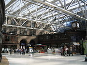
Glasgow Queen Street railway station
Glasgow Queen Street is a railway station in Glasgow, Scotland, the smaller of the city's two main line railway termini and the third-busiest station in Scotland. It is between George Street to the south and Cathedral Street Bridge to the north, at the northern end of Queen Street adjacent to...
, located on the northern periphery of the city centre connects Glasgow to the North of Scotland, and Edinburgh. Glasgow Central station, located on Argyle Street
Argyle Street, Glasgow
Argyle Street is a major thoroughfare in the city centre of Glasgow, Scotland.With Buchanan Street and Sauchiehall Street, Argyle Street forms the main shopping artery in the city centre...
is the northern terminus of the West Coast Main Line
West Coast Main Line
The West Coast Main Line is the busiest mixed-traffic railway route in Britain, being the country's most important rail backbone in terms of population served. Fast, long-distance inter-city passenger services are provided between London, the West Midlands, the North West, North Wales and the...
, and connects Glasgow with the South, and is the rail gateway to England
England
England is a country that is part of the United Kingdom. It shares land borders with Scotland to the north and Wales to the west; the Irish Sea is to the north west, the Celtic Sea to the south west, with the North Sea to the east and the English Channel to the south separating it from continental...
and the rest of the UK
United Kingdom
The United Kingdom of Great Britain and Northern IrelandIn the United Kingdom and Dependencies, other languages have been officially recognised as legitimate autochthonous languages under the European Charter for Regional or Minority Languages...
. Regular express train services run from Central to London
London
London is the capital city of :England and the :United Kingdom, the largest metropolitan area in the United Kingdom, and the largest urban zone in the European Union by most measures. Located on the River Thames, London has been a major settlement for two millennia, its history going back to its...
; terminating at either Euston or King's Cross.
There were two additional mainline stations serving the city at one stage. One, St Enoch Station
St Enoch railway station
-External links:* *...
, was sited at St Enoch Square not far from Central Station and parallel to the existing underground station of the same name, whilst the second, Buchanan Street Station
Buchanan Street railway station
Buchanan Street Station was the least known of Glasgow's four main terminal railway stations, the other three being Central, Queen St and St Enoch...
was located at the northern end of Buchanan Street, approximately just north of where the Royal Concert Hall currently stands near to Queen Street Station. These two stations were removed in the 1960s as a result of the Beeching Axe
Beeching Axe
The Beeching Axe or the Beeching Cuts are informal names for the British Government's attempt in the 1960s to reduce the cost of running British Railways, the nationalised railway system in the United Kingdom. The name is that of the main author of The Reshaping of British Railways, Dr Richard...
. The St Enoch Shopping Centre was built on the site of St Enoch Station in the 1980s and Buchanan House (formerly ScotRail House) and part of the Glasgow Caledonian University
Glasgow Caledonian University
Glasgow Caledonian University is a public university in Glasgow, Scotland.The university was constituted by an Act of Parliament on 1 April 1993 as a result of a merger between Glasgow Polytechnic and The Queen's College, Glasgow....
campus now stand on the site of Buchanan Street Station.
Plans were devised in the post-war period to redevelop Glasgow as a whole. As part of the resulting "Bruce Report
Bruce Report
The Bruce Report is the name commonly given to two urban redevelopment reports of the Glasgow Corporation ....
", it was proposed that Queen Street Station be demolished and replaced as a bus station and garage. Under this scheme only the low level Queen Street Station would be kept, as part of the suburban rail system, and a new purpose built Glasgow North Station would be constructed on the site of Buchanan Street Station. This plan was never followed through, and Queen Street operates to this day, although Buchanan Street Station closed in the 1960s. The chosen site for the Glasgow North Station is now occupied by the Buchanan Bus Station, the Buchanan Galleries shopping centre, the Royal Concert Hall and the Glasgow Passport Office. Glasgow and District Transport Plans from 1951 show the layout of the proposed station http://www.hipkiss.org/cgi-bin/maps.pl?book=British%20Transport%20Commission%20Passenger%20Transport%20In%20Glasgow%20And%20District.
The Bruce Report also recommended the demolition of both Glasgow Central and St Enoch Stations and replacing them with a Glasgow South Station, but again this was never followed up.
Suburban rail
There is also a suburban above-ground rail system run by First ScotRailFirst ScotRail
ScotRail Railways Ltd. is the FirstGroup-owned train operating company running domestic passenger trains within Scotland, northern England and the cross-border Caledonian Sleeper service to London using the brand ScotRail which is the property of the Scottish Government...
to the specification and requirements of SPT, who provide rolling stock in the SPT livery
Livery
A livery is a uniform, insignia or symbol adorning, in a non-military context, a person, an object or a vehicle that denotes a relationship between the wearer of the livery and an individual or corporate body. Often, elements of the heraldry relating to the individual or corporate body feature in...
of Carmine and Cream
Cream (colour)
Cream is the colour of the cream produced by cattle grazing on natural pasture with plants rich in yellow carotenoid pigments, some of which are incorporated into the cream, to give a yellow tone to white. Cream is the pastel colour of yellow, much like as pink is to red. Cream is used as a skin...
. It is centred on Central Station for the City south of the Clyde, the Ayrshire coast, and ferry ports on the Clyde. Queen Street Station is for links with Edinburgh and the east coast of Scotland and west to and north to the Highlands on the famous West Highland Line
West Highland Line
The West Highland Line is considered the most scenic railway line in Britain, linking the ports of Mallaig and Oban on the west coast of Scotland to Glasgow. The line was voted the top rail journey in the world by readers of independent travel magazine Wanderlust in 2009, ahead of the iconic...
. The North Clyde Line
North Clyde Line
The North Clyde Line is a suburban railway in West Central Scotland. The route is operated by First ScotRail, on behalf of Transport Scotland...
runs from Helensburgh and Balloch in the west to Edinburgh, passing through Queen Street Station. The rail based urban and suburban systems are run by Strathclyde Partnership for Transport
Strathclyde Partnership for Transport
The Strathclyde Partnership for Transport is a public body which is responsible for planning and co-ordinating regional transport, and especially the public transport system, in the Strathclyde area of western Scotland...
(SPT). SPT is formed and financed out of the twelve unitary authorities
Unitary authority
A unitary authority is a type of local authority that has a single tier and is responsible for all local government functions within its area or performs additional functions which elsewhere in the relevant country are usually performed by national government or a higher level of sub-national...
in the Greater Glasgow
Greater Glasgow
Greater Glasgow is an urban settlement in Scotland consisting of all localities which are physically attached to the city of Glasgow, forming with it a single contiguous urban area...
area including Glasgow City Council. It has responsibility for local train services, the Subway, certain ferries and buses. SPT runs the largest suburban rail network outside London, and incorporates 186 railway stations, 59 of them within Glasgow. There are links to East Kilbride
East Kilbride
East Kilbride is a large suburban town in the South Lanarkshire council area, in the West Central Lowlands of Scotland. Designated as Scotland's first new town in 1947, it forms part of the Greater Glasgow conurbation...
, Airdrie
Airdrie, North Lanarkshire
Airdrie is a town within North Lanarkshire, Scotland. It lies on a plateau roughly 400 ft above sea level, and is approximately 12 miles east of Glasgow city centre. Airdrie forms part of a conurbation with its neighbour Coatbridge, in the former district known as the Monklands. As of 2006,...
, Coatbridge
Coatbridge
Coatbridge is a town in North Lanarkshire, Scotland, about east of Glasgow city centre, set in the central Lowlands. The town, with neighbouring Airdrie, is part of the Greater Glasgow urban area. The first settlement of the area stretches back to the Stone Age era...
, Motherwell, Hamilton, Newton Mearns
Newton Mearns
Newton Mearns is a suburban town in East Renfrewshire, Scotland. It lies southwest of Glasgow City Centre on the main road to Ayrshire, above sea level. It has a population of approximately 22,637.The town is part of the Greater Glasgow conurbation...
, Paisley
Paisley
Paisley is the largest town in the historic county of Renfrewshire in the west central Lowlands of Scotland and serves as the administrative centre for the Renfrewshire council area...
, Greenock
Greenock
Greenock is a town and administrative centre in the Inverclyde council area in United Kingdom, and a former burgh within the historic county of Renfrewshire, located in the west central Lowlands of Scotland...
, Milngavie
Milngavie
Milngavie , is a town in East Dunbartonshire, Scotland. It is on the Allander Water, at the northwestern edge of Greater Glasgow, and about from Glasgow city centre. It neighbours Bearsden....
, Neilston
Neilston
Neilston is a village and parish in East Renfrewshire set in the west central Lowlands of Scotland. It lies in the Levern Valley, southwest of Barrhead, south of Paisley, and south-southwest of Renfrew, at the southwestern fringe of the Greater Glasgow conurbation...
, Largs
Largs
Largs is a town on the Firth of Clyde in North Ayrshire, Scotland, about from Glasgow. The original name means "the slopes" in Scottish Gaelic....
, Ardrossan
Ardrossan
Ardrossan is a town on the North Ayrshire coast in south-western Scotland. The name "Ardrossan" describes its physical position — 'ard' from the Gaelic àird meaning headland, 'ros' a promontory and the diminutive suffix '-an' - headland of the little promontory...
, Cumbernauld
Cumbernauld
Cumbernauld is a Scottish new town in North Lanarkshire. It was created in 1956 as a population overspill for Glasgow City. It is the eighth most populous settlement in Scotland and the largest in North Lanarkshire...
, Helensburgh
Helensburgh
Helensburgh is a town in Argyll and Bute, Scotland. It lies on the north shore of the Firth of Clyde and the eastern shore of the entrance to the Gareloch....
, Dumbarton, Balloch and Clydebank
Clydebank
Clydebank is a town in West Dunbartonshire, in the Central Lowlands of Scotland. Situated on the north bank of the River Clyde, Clydebank borders Dumbarton, the town with which it was combined to form West Dunbartonshire, as well as the town of Milngavie in East Dunbartonshire, and the Yoker and...
.
Future Plans
Locals have long pressed for a link which will join the two halves of the urban railway network together, making possible through journeys via the central area without having to disembark at either Central or Queen Street and traverse the city centre by foot or road. The Glasgow CrossrailGlasgow Crossrail
Crossrail Glasgow is a proposed railway development in Central Scotland.Since the 1970s, it has been widely recognised that one of the main weaknesses of the railway network in Greater Glasgow is that rail services from the South cannot bypass Glasgow city centre and join the northern...
initiative has been on the drawing board for many years, but still awaits funding from central government, despite the favourable outcomes of a feasibility study carried out in 2003.
Plans to connect Glasgow to London by a 270 mph Transrapid
Transrapid
Transrapid is a German high-speed monorail train using magnetic levitation. Based on a patent from 1934, planning of the Transrapid system started in 1969. The test facility for the system in Emsland, Germany was completed in 1987...
(German Maglev train
Maglev train
Maglev , is a system of transportation that uses magnetic levitation to suspend, guide and propel vehicles from magnets rather than using mechanical methods, such as friction-reliant wheels, axles and bearings...
) have emerged in June 2005. However, this proposal has now been shelved in favour of the proposed High Speed Two scheme from London to Birmingham, which may be extended to Glasgow.
There are also plans to connect Glasgow city with Glasgow International Airport, via a new rail link which it has been estimated will bring around 700 new jobs to the Paisley area. The Act of Parliament authorising construction of the link was passed by the Scottish Parliament on 29 November 2006 and received Royal Assent on 15 January 2007. It was expected that the link would be in operation by 2013 but is has recently been cancelled by the Scottish Parliament as a cost-cutting measure.
Major roads
Trunk road
A trunk road, trunk highway, or strategic road is a major road—usually connecting two or more cities, ports, airports, and other things.—which is the recommended route for long-distance and freight traffic...
network and has many road connections to other cities.
Glasgow has a less congested road network than Edinburgh
Edinburgh
Edinburgh is the capital city of Scotland, the second largest city in Scotland, and the eighth most populous in the United Kingdom. The City of Edinburgh Council governs one of Scotland's 32 local government council areas. The council area includes urban Edinburgh and a rural area...
, and the argument for congestion charging has not been as great. The city is linked to the rest of the country by the following main roads.
- A8/M8: Main east-west corridor which links Glasgow to Edinburgh, and GreenockGreenockGreenock is a town and administrative centre in the Inverclyde council area in United Kingdom, and a former burgh within the historic county of Renfrewshire, located in the west central Lowlands of Scotland...
to the west. - A82: Dumbarton, Loch LomondLoch LomondLoch Lomond is a freshwater Scottish loch, lying on the Highland Boundary Fault. It is the largest lake in Great Britain by surface area. The lake contains many islands, including Inchmurrin, the largest fresh-water island in the British Isles, although the lake itself is smaller than many Irish...
and the North West Highlands - A80/M80: StirlingStirlingStirling is a city and former ancient burgh in Scotland, and is at the heart of the wider Stirling council area. The city is clustered around a large fortress and medieval old-town beside the River Forth...
and the North East - A77/M77M77 motorwayThe M77 motorway is a motorway in Scotland. It originally began in southern Glasgow at the M8 motorway at Kinning park, and terminates near Kilmarnock at the village of Fenwick. However, changes were made in autumn 2005 segregating a lane on the M8 motorway almost as far as the Kingston Bridge,...
: KilmarnockKilmarnockKilmarnock is a large burgh in East Ayrshire, Scotland, with a population of 44,734. It is the second largest town in Ayrshire. The River Irvine runs through its eastern section, and the Kilmarnock Water passes through it, giving rise to the name 'Bank Street'...
, AyrAyrAyr is a town and port situated on the Firth of Clyde in south-west Scotland. With a population of around 46,000, Ayr is the largest settlement in Ayrshire, of which it is the county town, and has held royal burgh status since 1205...
and the South West - A74/M74M74 motorwayThe A74 and M74 motorways form a major motorway in Scotland. Following an extension opened on 28 June 2011, it connects the M8 motorway west of Glasgow to the English border at Gretna, creating an alternative route for traffic moving from the south to the west of the city...
: Main link to the South and England
City layout
The city centre is laid out on a grid planGrid plan
The grid plan, grid street plan or gridiron plan is a type of city plan in which streets run at right angles to each other, forming a grid...
, a result of the westward expansion from the old medieval core during the Georgian era
Georgian era
The Georgian era is a period of British history which takes its name from, and is normally defined as spanning the reigns of, the first four Hanoverian kings of Great Britain : George I, George II, George III and George IV...
, initially into the area now called the Merchant City. Much of the initial grid can be credited to a surveyor named James Barry. The desire to create a regular layout of streets fits in well with the Enlightenment ideas about rationality: at the same time, similar developments were taking place in Edinburgh
Edinburgh
Edinburgh is the capital city of Scotland, the second largest city in Scotland, and the eighth most populous in the United Kingdom. The City of Edinburgh Council governs one of Scotland's 32 local government council areas. The council area includes urban Edinburgh and a rural area...
, with the creation of the New Town. Despite this, the layout is not very regular, due to the awkward topography, with numerous drumlin
Drumlin
A drumlin, from the Irish word droimnín , first recorded in 1833, is an elongated whale-shaped hill formed by glacial ice acting on underlying unconsolidated till or ground moraine.-Drumlin formation:...
s, as well as the generation of point de vues out of the existing Palladian mansions in the Merchant City, all but one now demolished. This layout makes it relatively car friendly, despite the numerous and confusing one-way systems.
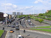
Inner Ring Road
The aforementioned Bruce Report not only recommended the construction of two major new railway stations, but also the construction of an inner ring road of motorway that circled the city centre. Despite being proposed in the aftermath of the Second World War it was not until the 1960s that this project was begun. This involved the construction of the M8 motorway through the east end of the city along the route of the old Monkland Canal. This part of the project was fairly non controversial as the canal was in a poor state and not really in use by this time. This portion of the ring road would form the northern flank.What was more controversial of the M8 was where it would form the western flank of the ring road, which involved the destruction of many properties in the Woodlands
Woodlands, Glasgow
Woodlands is a residential area in the west-end of Glasgow, Scotland. It is to the east of Hillhead, the south of Maryhill and Woodside, and north of the city's Park District...
, Garnethill
Garnethill
Garnethill is a predominantly residential area of the city of Glasgow, Scotland.-Geography:Located in the city centre, the area borders Cowcaddens to its north, Sauchiehall Street to its south, Cambridge Street to its east and the M8 motorway to its west....
and Anderston
Anderston
Anderston is a district in the Scottish city of Glasgow. It is on the north bank of the River Clyde and extends to the western edge of the city centre...
areas, which have been left unrecognisable from the period the motorway was constructed. The ring road then continued across the Kingston Bridge
Kingston Bridge, Glasgow
The Kingston Bridge is a balanced cantilever dual-span ten lane road bridge made of triple-cell segmented prestressed concrete box girders crossing the River Clyde in Glasgow, Scotland. The largest urban bridge in the United Kingdom, it carries the M8 motorway through the city centre...
over the River Clyde
River Clyde
The River Clyde is a major river in Scotland. It is the ninth longest river in the United Kingdom, and the third longest in Scotland. Flowing through the major city of Glasgow, it was an important river for shipbuilding and trade in the British Empire....
to the southside of the city.
This is where the ring road project was left incomplete. The M8 continues towards Greenock
Greenock
Greenock is a town and administrative centre in the Inverclyde council area in United Kingdom, and a former burgh within the historic county of Renfrewshire, located in the west central Lowlands of Scotland...
through the Southwest of Glasgow, but the ring road project was not finished as the M8 forms only the northern and western flanks of it. The plan called for an eastern and southern flank as well which were never put in place, even though turn offs on certain sections of the motorway were built to connect with these.
However, it seems that a southern portion will now be built as the Scottish Executive
Scottish Executive
The Scottish Government is the executive arm of the devolved government of Scotland. It was established in 1999 as the Scottish Executive, from the extant Scottish Office, and the term Scottish Executive remains its legal name under the Scotland Act 1998...
has determined that the M74 motorway
M74 motorway
The A74 and M74 motorways form a major motorway in Scotland. Following an extension opened on 28 June 2011, it connects the M8 motorway west of Glasgow to the English border at Gretna, creating an alternative route for traffic moving from the south to the west of the city...
will be extended through the Southeast of Glasgow to connect with the Kingston Bridge (although not along the original route identified in the Bruce Report). This is a controversial plan as it involves plowing the motorway through the city, something that many residents do not want, and a public enquiry recommended that construction not proceed. However the Executive contends that the economic benefits as well as congestion on the current motorway dictate that it will go ahead. Despite this, the opposers to the scheme mounted a legal challenge in June 2005, which will probably mean that opening of the extension will be delayed until 2009 at the earliest. The City Council have indicated that should this extension be complete they will reconsider building the eastern flank of the ring road which will necessitate either a second motorway bridge over the river, or a tunnel.
The ring road plan also called for a motorway out from the centre of the city to the north-west (as the ring road plan would have involved four motorways running off of the central ring - a northeast one, which is the M8 from Glasgow city centre to Edinburgh
Edinburgh
Edinburgh is the capital city of Scotland, the second largest city in Scotland, and the eighth most populous in the United Kingdom. The City of Edinburgh Council governs one of Scotland's 32 local government council areas. The council area includes urban Edinburgh and a rural area...
; a southwest one, which is the M8 from Glasgow city centre to Greenock; a southeast one, the projected M74 extension; and a northwest one, which would have left the Inner Ring Road at Woodside (slip road stubs are visible) and followed the path of the Forth & Clyde Canal up through the Maryhill area of Glasgow to Milngavie and beyond).
While there are no plans to build motorway-standard flank of the ring road at national government level, Glasgow City Council have recently published new plans for what it calls the Glasgow East End Regeneration Route (EERR). This would appear not to be a motorway, but instead an urban corridor which will connect the M74 extension at Polmadie with the M8/M80 at Provan. While the Council has openly voiced its commitment to the plan, it will likely face considerable controversy since its path will dissect the suburbs of Bridgeton, Carntyne
Carntyne
Carntyne is a district in the Scottish city of Glasgow. It is situated north of the River Clyde, and to the east end of the city...
and Parkhead
Parkhead
Parkhead is a district in the East End of Glasgow. Its name comes from a small weaving hamlet at the meeting place of the Great Eastern Road and Westmuir Street. Duke Street and Springfield Road also meet there, to form a turreted Edwardian five-way junction at Parkhead Cross...
making use of derelict land and an abandoned railway embankment.
Glasgow Subway

Great Britain
Great Britain or Britain is an island situated to the northwest of Continental Europe. It is the ninth largest island in the world, and the largest European island, as well as the largest of the British Isles...
metropolitan areas that has an underground metro system; the others being London
London
London is the capital city of :England and the :United Kingdom, the largest metropolitan area in the United Kingdom, and the largest urban zone in the European Union by most measures. Located on the River Thames, London has been a major settlement for two millennia, its history going back to its...
and Tyne and Wear
Tyne and Wear
Tyne and Wear is a metropolitan county in north east England around the mouths of the Rivers Tyne and Wear. It came into existence as a metropolitan county in 1974 after the passage of the Local Government Act 1972...
. The Glasgow Subway
Glasgow Subway
The Glasgow Subway is an underground metro line in Glasgow, Scotland. Opened on 14 December 1896, it is the third-oldest underground metro system in the world after the London Underground and the Budapest Metro. Formerly a cable railway, the Subway was later electrified, but its twin circular lines...
(previously Glasgow Underground), was built in 1896 and substantially modernised in 1977. It has a single circular route. This, taken together with the orange-coloured paintwork of the carriages, has led to it being known, by guidebooks more than the locals who still refer to it as the "Subway", as "The Clockwork Orange".
Despite being the third oldest subway system in the world (after London's
London Underground
The London Underground is a rapid transit system serving a large part of Greater London and some parts of Buckinghamshire, Hertfordshire and Essex in England...
and Budapest's
Budapest Metro
The Budapest Metro is the rapid transit system in the Hungarian capital Budapest. It is the second-oldest underground metro system in the world after the London Underground. Its iconic Line 1, dating from 1896, was declared a World Heritage Site in 2002.-Lines:The Metro consists of three lines,...
), it has never been expanded beyond its original route. Reasons given for this have invariably related to Glasgow's geology: the tunnels are excavated from rock, and for this reason they are also smaller than London's. An SPT study into a possible expansion of the subway has been mooted. It would extend further into the West End, East End and Southside of the city which may cost up to £800million to build. Much of this expansion might utilise disused railway tunnels that have been abandoned since the Beeching
Richard Beeching
Richard Beeching, Baron Beeching , commonly known as Doctor Beeching, was chairman of British Railways and a physicist and engineer...
cuts of the 1960s.
Bus
Deregulation of bus services began in October 1986, since that time bus operators have been able to start new services, change services, or cancel existing services by giving 42 days' notice to the relevant authorities; in Scotland this has since changed to 56 days notice with an additional 14 day consultation period over and above this. Operation of non commercial services that SPT deem to be socially necessary may be awarded by competitive tender.A number of 'bus corridors
Bus lane
A bus lane or bus only lane is a lane restricted to buses, and generally used to speed up public transport that would be otherwise held up by traffic congestion...
' have been invested in by Glasgow City Council focusing on main bus routes with real time information, and bus priority
Bus priority
Bus priority or transit signal priority is a name for various techniques to speed up bus public transport services at intersections with traffic signals amongst other methods. Trams and light rail vehicles can also be given priority...
measures. The Greater Glasgow Passenger Transport Executive (GGPTE), formerly the municipal transport operator, is now privately owned by First Group.
The largest bus operators in the City are:
- FirstFirst GlasgowFirst Glasgow is the largest bus company serving the Greater Glasgow area in, Scotland. It forms part of FirstGroup, a company operating transport services across the British Isles and in North America...
- (part of First Group) who are the successors to the former Glasgow Corporation Transport Department, and the former Central and Kelvin subsidiaries of the Scottish Bus Group. - ArrivaArriva Scotland WestArriva Scotland West Ltd is a bus operating subsidiary of Arriva based in Inchinnan, near Paisley, Scotland, trading simply as Arriva. It is currently the group's sole operation in Scotland.-Operation:...
- The successors to the former Clydeside subsidiary of the Scottish Bus Group. - Stagecoach - The successors to the former Western subsidiary of the Scottish Bus Group, with their Stagecoach Glasgow company competing on several city routes.
- Glasgow CitybusGlasgow CitybusGlasgow Citybus is a Scottish bus operator, operating a number of bus routes throughout Greater Glasgow, primarily in Glasgow and Dunbartonshire...
- Independent company providing services in the North West Glasgow area.
Buchanan Bus Station
Buchanan bus station
Buchanan Bus Station is the main bus terminus in Glasgow, Scotland.The bus station is the terminus for journeys between the city and other towns in United Kingdom and international journeys. It was originally built in 1977, close to the former site of Buchanan Street railway station which was...
is owned and run by SPT, and is a terminus for both local and long-distance services
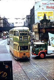
Trams
Glasgow had for many years an extensive system of trams that ran on the city's streets alongside other traffic. However, by the 1950s much of the vehicle stock was over 30 years old and in need of replacement. The trams were becoming less used as car use increased and gradually the tram network was phased out across the city, including many routes that were still fairly well used and reckoned to be economically viable. The last tram in the city ran on September 4, 1962 with as many as 250,000 people reckoned to have lined the streets to watch this spectacle.In the mid 1990s there emerged a plan to create a Strathclyde Tram Project, which would have seen the reintroduction of trams to Glasgow. Strathclyde Passenger Transport published a set of plans for this system, going so far as to distribute pamphlets across the city outlining these plans and the proposed routes they were suggesting. The initial line proposed was a 20-kilometre route that would run from Maryhill
Maryhill
Maryhill is an area of the City of Glasgow in Scotland. Maryhill is a former burgh. The population of Maryhill is about 52,000. Maryhill stretches over along Maryhill Road...
in the Northwest of the city to Easterhouse
Easterhouse
Easterhouse is a suburb about east of Glasgow city centre, Scotland. It was partially built on land gained from the county of Lanarkshire as part of a boundary expansion of Glasgow before the Second World War. Building began in the mid-1950s by the then local authority, Glasgow Corporation...
on Glasgow's Eastern fringe. It was envisaged that the line would utilise disused railway lines and tunnels as well as running in part on some roads in the city alongside other traffic. The plan then outlined future expansion of the tram network so that it might one day stretch across the Greater Glasgow area.
However, there were a number of objections to these proposals, contentiously amongst them was an objection from Strathclyde Bus Holdings, who it could be argued did so out of fear of their profit margins being affected by such an initiative. This necessitated a public inquiry which lasted around 10 weeks. The Parliamentary Commissioners appointed to deliberate on the matter met and discussed the conclusions of this inquiry in a matter of hours before finding in favour of the objections raised thus killing off the Strathclyde Tram Project. The reasoning of the Commissioners is unknown as there existed no obligation from them to reveal it.
There currently exists a proposal to reintroduce trams (again, as in 1996, this would actually be a light rail system) to Glasgow. This comes in light of similar proposals, which are much further advanced, to reintroduce trams to Edinburgh
Edinburgh
Edinburgh is the capital city of Scotland, the second largest city in Scotland, and the eighth most populous in the United Kingdom. The City of Edinburgh Council governs one of Scotland's 32 local government council areas. The council area includes urban Edinburgh and a rural area...
. The City of Glasgow Council and SPT have commissioned a £500,000 study to see the viability of such a system which it is reckoned would initially operate from the city centre out to the new Glasgow Harbour
Glasgow Harbour
Glasgow Harbour is an urban regeneration scheme at Partick in the city of Glasgow, Scotland.After many years of dereliction caused by the decline of shipbuilding and the migration of Glasgow's docks to the Firth of Clyde, since the mid 1980s, the banks of the River Clyde at Glasgow have become a...
site then across the River Clyde
River Clyde
The River Clyde is a major river in Scotland. It is the ninth longest river in the United Kingdom, and the third longest in Scotland. Flowing through the major city of Glasgow, it was an important river for shipbuilding and trade in the British Empire....
to the Southern General Hospital and through Govan
Govan
Govan is a district and former burgh now part of southwest City of Glasgow, Scotland. It is situated west of Glasgow city centre, on the south bank of the River Clyde, opposite the mouth of the River Kelvin and the district of Partick....
and along the south bank of the Clyde before crossing the river again back into the city centre. There are proposals to run trams further than this route out to the Braehead shopping centre and possibly Glasgow Airport; to Clydebank; and across the rest of the city.
Presently SPT has decided that this route will not see trams running along it, but rather an "ultra-modern" bus service termed "Clyde Fastlink
Clyde Fastlink
Clyde FastLink is a proposed high frequency dedicated bus link in Glasgow, United Kingdom. It is planned to run between Glasgow city centre and several local and regional destinations, including Glasgow Harbour, the Scottish Exhibition and Conference Centre and Renfrew. The scheme is being led by...
" will operate part of the route, running from the city centre to the Glasgow Harbour area. SPT have stated however that they are leaving open the option of laying tram lines on this route and replacing the buses with a light rail system.
Trolleybuses
Glasgow Corporation Transport Department also operated a small trolleybusTrolleybus
A trolleybus is an electric bus that draws its electricity from overhead wires using spring-loaded trolley poles. Two wires and poles are required to complete the electrical circuit...
system between 1949 and 1967, using electricity generated from the same power station as the trams.
See also
- Transport in ScotlandTransport in ScotlandThe transport system in Scotland is generally well-developed. The Scottish Parliament has control over most elements of transport policy within Scotland and the Scottish Government's Enterprise, Transport and Lifelong Learning Department is responsible for the Scottish transport network with...
Full bus, train and ferry information is available from Traveline Scotland