
Superior National Forest
Encyclopedia
United States National Forest
National Forest is a classification of federal lands in the United States.National Forests are largely forest and woodland areas owned by the federal government and managed by the United States Forest Service, part of the United States Department of Agriculture. Land management of these areas...
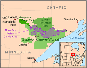
system, is located in the Arrowhead Region
Arrowhead Region
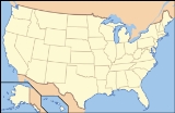
The Arrowhead Region is located in the northeastern part of the U.S. state of Minnesota, so called because of its pointed shape. The predominantly rural region encompasses of land area and comprises Carlton, Cook, Lake and St. Louis Counties. Its population at the 2000 census was 248,425 residents...
of the state
U.S. state
A U.S. state is any one of the 50 federated states of the United States of America that share sovereignty with the federal government. Because of this shared sovereignty, an American is a citizen both of the federal entity and of his or her state of domicile. Four states use the official title of...
of Minnesota
Minnesota
Minnesota is a U.S. state located in the Midwestern United States. The twelfth largest state of the U.S., it is the twenty-first most populous, with 5.3 million residents. Minnesota was carved out of the eastern half of the Minnesota Territory and admitted to the Union as the thirty-second state...
between the Canada – United States border and the north shore
North Shore (Lake Superior)
The North Shore of Lake Superior runs from Duluth, Minnesota, United States, at the southwestern end of the lake, to Thunder Bay and Nipigon, Ontario, Canada, in the north to Sault Ste. Marie, Ontario, in the east...
of Lake Superior
Lake Superior
Lake Superior is the largest of the five traditionally-demarcated Great Lakes of North America. It is bounded to the north by the Canadian province of Ontario and the U.S. state of Minnesota, and to the south by the U.S. states of Wisconsin and Michigan. It is the largest freshwater lake in the...
. The area is part of the greater Boundary Waters
Boundary Waters
The Boundary Waters — also called the Quetico-Superior country — is a region of wilderness straddling the Canada–United States border between Ontario and Minnesota, in the region just west of Lake Superior. This region is part of the Superior National Forest in northeastern Minnesota, and in Canada...
region along the border of Minnesota and the Canadian province of Ontario
Ontario
Ontario is a province of Canada, located in east-central Canada. It is Canada's most populous province and second largest in total area. It is home to the nation's most populous city, Toronto, and the nation's capital, Ottawa....
, a historic and important thoroughfare in the fur trading
Fur trade
The fur trade is a worldwide industry dealing in the acquisition and sale of animal fur. Since the establishment of world market for in the early modern period furs of boreal, polar and cold temperate mammalian animals have been the most valued...
and exploring days of British North America
British North America
British North America is a historical term. It consisted of the colonies and territories of the British Empire in continental North America after the end of the American Revolutionary War and the recognition of American independence in 1783.At the start of the Revolutionary War in 1775 the British...
.
Under the administration of the United States Forest Service
United States Forest Service
The United States Forest Service is an agency of the United States Department of Agriculture that administers the nation's 155 national forests and 20 national grasslands, which encompass...
, the Superior National Forest comprises over 3,900,000 acres (6,100 mi2 or 16,000 km2) of woods and waters. The majority of the forest is multiple-use, including both logging and recreational activities such as camping, boating, and fishing. Slightly over a quarter of the forest however is set aside as a wilderness reserve known as the Boundary Waters Canoe Area (BWCA), where canoe
Canoe
A canoe or Canadian canoe is a small narrow boat, typically human-powered, though it may also be powered by sails or small electric or gas motors. Canoes are usually pointed at both bow and stern and are normally open on top, but can be decked over A canoe (North American English) or Canadian...
rs can travel along interconnected lakes and rivers and over historic portage
Portage
Portage or portaging refers to the practice of carrying watercraft or cargo over land to avoid river obstacles, or between two bodies of water. A place where this carrying occurs is also called a portage; a person doing the carrying is called a porter.The English word portage is derived from the...
s once used by the First Nations
First Nations
First Nations is a term that collectively refers to various Aboriginal peoples in Canada who are neither Inuit nor Métis. There are currently over 630 recognised First Nations governments or bands spread across Canada, roughly half of which are in the provinces of Ontario and British Columbia. The...
and later by European explorers and traders.
Location
The forest is located in CookCook County, Minnesota
Northern Minnesota offers extreme winter weather. While the averages are low, the extremes provide more details. A third of the year is below freezing . Of those days, 21 are below zero degrees Fahrenheit .-External links:...
, Lake
Lake County, Minnesota
Lake County is a county located in the U.S. state of Minnesota. As of 2010, the population was 10,866. Its county seat is Two Harbors. Lake County was founded on February 20, 1855, as Superior County, though its name was changed on March 3, of that year to St. Louis County. On March 1, 1856, St...
, and St. Louis
St. Louis County, Minnesota
St. Louis County is a county located in the U.S. state of Minnesota. As of 2010, the population was 200,226. Its county seat is Duluth. It is the largest county by total area in Minnesota, and the second largest in the United States east of the Mississippi River; in land area alone, after Aroostook...
Counties in northeastern Minnesota. Forest headquarters are located in Duluth, Minnesota
Duluth, Minnesota
Duluth is a port city in the U.S. state of Minnesota and is the county seat of Saint Louis County. The fourth largest city in Minnesota, Duluth had a total population of 86,265 in the 2010 census. Duluth is also the second largest city that is located on Lake Superior after Thunder Bay, Ontario,...
, outside the boundaries of the forest. There are local ranger district offices in Aurora
Aurora, Minnesota
Aurora is a city in Saint Louis County, Minnesota, United States. The population was 1,682 at the 2010 census.State Highway 135, County Highway 100, and County Highway 110 are three of the main arterial routes in the community.-Geography:...
, Cook
Cook, Minnesota
Cook is a city in Saint Louis County, Minnesota, United States. The population was 574 at the 2010 census.U.S. Highway 53 and Minnesota Highway 1 are two of the main arterial routes in the community....
, Ely
Ely, Minnesota
As of the census of 2000, there were 3,724 people, 1,912 households, and 916 families residing in the city. The population density was 1,369.5 people per square mile . There were 1,912 housing units at an average density of 703.2 per square mile...
, Grand Marais
Grand Marais, Minnesota
Grand Marais is a city in Cook County, Minnesota, United States. The population was 1,351 at the 2010 census. It is also the county seat of Cook County...
, and Tofte
Tofte, Minnesota
Tofte is an unincorporated community in Cook County, Minnesota, United States. Tofte is located on Minnesota State Highway 61 between Grand Marais and Little Marais....
.
Landforms
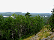
The forest covers 3.9 million acres (6,100 mi2 or 16,000 km2), and has over 445,000 acres (1,800 km2) of water. Its waters include some 2000 lakes and rivers, more than 1,300 miles (2,100 km) of cold water streams, and 950 miles (1,530 km) of warm water streams. Many of the lakes are located in depressions formed by the diffential erosion of tilted layers of bedded rock; these depressions were given their final form by glacial scouring during recent ice ageIce age
An ice age or, more precisely, glacial age, is a generic geological period of long-term reduction in the temperature of the Earth's surface and atmosphere, resulting in the presence or expansion of continental ice sheets, polar ice sheets and alpine glaciers...
s.
Canadian Shield
The Canadian Shield, also called the Laurentian Plateau, or Bouclier Canadien , is a vast geological shield covered by a thin layer of soil that forms the nucleus of the North American or Laurentia craton. It is an area mostly composed of igneous rock which relates to its long volcanic history...
. The area is on a low plateau which is part of the Superior Upland. High points include the Sawtooth Mountains
Sawtooth Mountains (Minnesota)
The Sawtooth Mountains are a range of low, serrated ridges situated on the North Shore of Lake Superior in the U.S. state of Minnesota, extending about 30 miles from Carlton Peak near Tofte on the west, to Grand Marais on the east.-Description:...
, a range of hills along the shore of Lake Superior
Lake Superior
Lake Superior is the largest of the five traditionally-demarcated Great Lakes of North America. It is bounded to the north by the Canadian province of Ontario and the U.S. state of Minnesota, and to the south by the U.S. states of Wisconsin and Michigan. It is the largest freshwater lake in the...
, the Misquah Hills
Misquah Hills
The Misquah Hills are a range of large hills or small mountains in northeastern Minnesota, in the United States. They are located in or near the Boundary Waters Canoe Area Wilderness within Superior National Forest...
including Eagle Mountain
Eagle Mountain (Minnesota)
Eagle Mountain is the highest natural point in Minnesota, at . It is located in northern Cook County and is in the Boundary Waters Canoe Area Wilderness and Superior National Forest in the Misquah Hills, northwest of the community of Grand Marais. It is a Minnesota State Historic Site.Eagle...
, the state's highest point, and other uplands along the Laurentian Divide
Laurentian Divide
The Laurentian Divide or Northern Divide is a continental divide dividing the direction of water flow in eastern and southern Canada and the northern Midwestern United States. Water north of the height of land flows to the Arctic Ocean by rivers to Hudson Bay or directly to the Arctic...
separating the watershed
Drainage basin
A drainage basin is an extent or an area of land where surface water from rain and melting snow or ice converges to a single point, usually the exit of the basin, where the waters join another waterbody, such as a river, lake, reservoir, estuary, wetland, sea, or ocean...
of the Great Lakes
Great Lakes
The Great Lakes are a collection of freshwater lakes located in northeastern North America, on the Canada – United States border. Consisting of Lakes Superior, Michigan, Huron, Erie, and Ontario, they form the largest group of freshwater lakes on Earth by total surface, coming in second by volume...
and Atlantic Ocean
Atlantic Ocean
The Atlantic Ocean is the second-largest of the world's oceanic divisions. With a total area of about , it covers approximately 20% of the Earth's surface and about 26% of its water surface area...
from that of Hudson Bay
Hudson Bay
Hudson Bay , sometimes called Hudson's Bay, is a large body of saltwater in northeastern Canada. It drains a very large area, about , that includes parts of Ontario, Quebec, Saskatchewan, Alberta, most of Manitoba, southeastern Nunavut, as well as parts of North Dakota, South Dakota, Minnesota,...
and the Arctic Ocean
Arctic Ocean
The Arctic Ocean, located in the Northern Hemisphere and mostly in the Arctic north polar region, is the smallest and shallowest of the world's five major oceanic divisions...
. Despite the presence of dramatic cliffs and other local differences in elevation, the area is essentially flat, as it is part of an old peneplain
Peneplain
A peneplain is a low-relief plain representing the final stage of fluvial erosion during times of extended tectonic stability. The existence of peneplains, and peneplanation as a geomorphological process, is not without controversy, due to a lack of contemporary examples and uncertainty in...
eroded by weathering, water, and especially glaciers.
The principal surficial result of recent glaciation is not the deposition of glacial drift (unlike most of the rest of the state), but the remodeling of the landscape by the scraping away of softer surfaces down to bare hard rock. The land therefore is raw, with many outcroppings of ancient bedrock, overlain in places by thin layers of gravelly soil and, in the west, silts deposited by Glacial Lake Agassiz.
Flora
The forest contains both true boreal forest (taigaTaiga
Taiga , also known as the boreal forest, is a biome characterized by coniferous forests.Taiga is the world's largest terrestrial biome. In North America it covers most of inland Canada and Alaska as well as parts of the extreme northern continental United States and is known as the Northwoods...
), and a mixed conifer-hardwood forest known as the North Woods
North Woods
The Laurentian Mixed Forest Province, also known as the North Woods, is a forested ecoregion in Canada and the United States. In Canada it is found in Ontario around the Great Lakes and the Saint Lawrence River through Quebec to Quebec City...
, a transition province between the northern boreal forest and deciduous forests to the south. Conifers include several varieties of pine
Pine
Pines are trees in the genus Pinus ,in the family Pinaceae. They make up the monotypic subfamily Pinoideae. There are about 115 species of pine, although different authorities accept between 105 and 125 species.-Etymology:...
, fir
Fir
Firs are a genus of 48–55 species of evergreen conifers in the family Pinaceae. They are found through much of North and Central America, Europe, Asia, and North Africa, occurring in mountains over most of the range...
, and spruce
Spruce
A spruce is a tree of the genus Picea , a genus of about 35 species of coniferous evergreen trees in the Family Pinaceae, found in the northern temperate and boreal regions of the earth. Spruces are large trees, from tall when mature, and can be distinguished by their whorled branches and conical...
trees, principal deciduous
Deciduous
Deciduous means "falling off at maturity" or "tending to fall off", and is typically used in reference to trees or shrubs that lose their leaves seasonally, and to the shedding of other plant structures such as petals after flowering or fruit when ripe...
species are mountain ash
Sorbus
Sorbus is a genus of about 100–200 species of trees and shrubs in the subfamily Maloideae of the Rose family Rosaceae. Species of Sorbus are commonly known as whitebeam, rowan, service tree, and mountain ash...
, maple
Maple
Acer is a genus of trees or shrubs commonly known as maple.Maples are variously classified in a family of their own, the Aceraceae, or together with the Hippocastanaceae included in the family Sapindaceae. Modern classifications, including the Angiosperm Phylogeny Group system, favour inclusion in...
, aspen
Populus tremuloides
Populus tremuloides is a deciduous tree native to cooler areas of North America, commonly called quaking aspen, trembling aspen, American aspen, and Quakies,. The trees have tall trunks, up to 25 metres, with smooth pale bark, scarred with black. The glossy green leaves, dull beneath, become golden...
, oak
Oak
An oak is a tree or shrub in the genus Quercus , of which about 600 species exist. "Oak" may also appear in the names of species in related genera, notably Lithocarpus...
, and paper birch
Paper Birch
Betula papyrifera is a species of birch native to northern North America.-Description:...
are also common. Characteristic aquatic plants include water lilies
Nelumbo lutea
Nelumbo lutea is a species of flowering plant in the monogeneric family Nelumbonaceae. Common names include American lotus, yellow lotus, water-chinquapin, and volée. It is native to North America...
and wild rice
Wild rice
Wild rice is four species of grasses forming the genus Zizania, and the grain which can be harvested from them. The grain was historically gathered and eaten in both North America and China...
.
Fauna
Fish species such as walleyeWalleye
Walleye is a freshwater perciform fish native to most of Canada and to the northern United States. It is a North American close relative of the European pikeperch...
, northern pike
Northern Pike
The northern pike , is a species of carnivorous fish of the genus Esox...
, smallmouth bass
Smallmouth bass
The smallmouth bass is a species of freshwater fish in the sunfish family of the order Perciformes. It is the type species of its genus...
, lake trout
Lake trout
Lake trout is a freshwater char living mainly in lakes in northern North America. Other names for it include mackinaw, lake char , touladi, togue, and grey trout. In Lake Superior, they can also be variously known as siscowet, paperbellies and leans...
, brook trout
Brook trout
The brook trout, Salvelinus fontinalis, is a species of fish in the salmon family of order Salmoniformes. In many parts of its range, it is known as the speckled trout or squaretail. A potamodromous population in Lake Superior are known as coaster trout or, simply, as coasters...
, rainbow trout
Rainbow trout
The rainbow trout is a species of salmonid native to tributaries of the Pacific Ocean in Asia and North America. The steelhead is a sea run rainbow trout usually returning to freshwater to spawn after 2 to 3 years at sea. In other words, rainbow trout and steelhead trout are the same species....
, and brown trout
Brown trout
The brown trout and the sea trout are fish of the same species....
can be found in abundance in the forest's waters. Larger wildlife species include white-tailed deer
White-tailed Deer
The white-tailed deer , also known as the Virginia deer or simply as the whitetail, is a medium-sized deer native to the United States , Canada, Mexico, Central America, and South America as far south as Peru...
, moose
Moose
The moose or Eurasian elk is the largest extant species in the deer family. Moose are distinguished by the palmate antlers of the males; other members of the family have antlers with a dendritic configuration...
, Canadian Lynx, American black bear
American black bear
The American black bear is a medium-sized bear native to North America. It is the continent's smallest and most common bear species. Black bears are omnivores, with their diets varying greatly depending on season and location. They typically live in largely forested areas, but do leave forests in...
, and the gray or timber wolf
Gray Wolf
The gray wolf , also known as the wolf, is the largest extant wild member of the Canidae family...
. Northern Minnesota has the largest population of gray wolves in the lower 48 states, with approximately 300-400 wolves within the boundaries of the Superior National Forest. Located at the northern edge of the range of the hummingbird
Hummingbird
Hummingbirds are birds that comprise the family Trochilidae. They are among the smallest of birds, most species measuring in the 7.5–13 cm range. Indeed, the smallest extant bird species is a hummingbird, the 5-cm Bee Hummingbird. They can hover in mid-air by rapidly flapping their wings...
and near the southern edge of the range of the Canada Jay, the forest has 163 nesting species of birds, the largest number of any national forest. Species include the Bald Eagle
Bald Eagle
The Bald Eagle is a bird of prey found in North America. It is the national bird and symbol of the United States of America. This sea eagle has two known sub-species and forms a species pair with the White-tailed Eagle...
and other raptors
Bird of prey
Birds of prey are birds that hunt for food primarily on the wing, using their keen senses, especially vision. They are defined as birds that primarily hunt vertebrates, including other birds. Their talons and beaks tend to be relatively large, powerful and adapted for tearing and/or piercing flesh....
, the ubiquitous common loon, and northern waterfowl
Waterfowl
Waterfowl are certain wildfowl of the order Anseriformes, especially members of the family Anatidae, which includes ducks, geese, and swans....
.
History
In June 2008, legislation was introduced in the U.S. House of Representatives to sell 6700 acres (27.1 km²) of land in the forest to a mining company; the company wants the land to mine deposits of "copper, nickel, platinum and palladium".Recreation
The Superior National Forest maintains developed fee campgrounds with amenities like drinking water and garbage disposal, rustic campgrounds without drinking water or fees, and backcountry campsites with only a pit latrine and a fire grate, and no permits or fees. Additionally, dispersed camping is permitted anywhere on undeveloped public land without permit or fee. An exception is made for the designated wilderness of the Boundary Waters Canoe Area, which requires special permits for entrance.Fee Campgrounds
Tofte Ranger District- Crescent Lake
- Divide Lake
- Little Isabella RiverLittle Isabella River-See also:*List of rivers of Minnesota-References:**USGS Hydrologic Unit Map - State of Minnesota...
- McDougal Lake
- Ninemile Lake
- Sawbill LakeSawbill LakeSawbill Lake is a lake in Cook County, Minnesota. It is a popular entry point to the Boundary Waters Canoe Area Wilderness in the Superior National Forest. Sawbill is a nickname of a Common Merganser Duck. There is a United States Forest Service cabin, a canoe outfitter, and a campground...
- Temperance RiverTemperance RiverThe Temperance River is a river in northern Minnesota, which drains into Lake Superior along its north shore just south of Tofte. It flows out of Brule Lake in Cook County towards its mouth within Temperance River State Park. Its name is supposedly a pun on its lack of a sand bar.-Name:The...
See also
- List of U.S. national forests
- Chippewa National ForestChippewa National ForestChippewa National Forest is a National Forest located in northcentral Minnesota, United States, in the counties of Itasca, Cass, and Beltrami. Forest headquarters are located in Cass Lake, Minnesota. There are local ranger district offices in Blackduck, Deer River, and Walker.-History and...
- List of Minnesota trees
- List of U.S. Wilderness Areas
- International Boundary Waters TreatyInternational Boundary Waters TreatyThe Boundary Waters Treaty is the 1909 treaty between the United States and Canada providing mechanisms for resolving any dispute over any waters bordering the two countries...
- The BWCAWiki
General references
- Superior National Forest - USFS History (Forest History SocietyForest History SocietyThe Forest History Society is an American non-profit organization dedicated to the preservation of forest and conservation history. The society was established in 1946 and incorporated in 1955....
) - Website of the Superior National Forest
- History of the Superior National Forest
- A map of The forest
Parts of this article were taken from the Forest Service
United States Forest Service
The United States Forest Service is an agency of the United States Department of Agriculture that administers the nation's 155 national forests and 20 national grasslands, which encompass...
website. As a work
Work of the United States Government
A work of the United States government, as defined by United States copyright law, is "a work prepared by an officer or employee of the U.S. government as part of that person's official duties." The term only applies to the work of the federal government, including the governments of "non-organized...
of the U.S. federal government, the text is in the public domain
Public domain
Works are in the public domain if the intellectual property rights have expired, if the intellectual property rights are forfeited, or if they are not covered by intellectual property rights at all...
.