
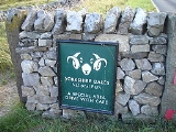
Yorkshire Dales
Encyclopedia
The Yorkshire Dales is the name given to an upland area in Northern England
.
The area lies within the historic county boundaries
of Yorkshire
, though it spans the ceremonial counties
of North Yorkshire
, West Yorkshire
and Cumbria
. Most of the area falls within the Yorkshire Dales National Park, created in 1954, and now one of the fifteen National parks of Britain, but the term also includes areas to the east of the National Park, notably Nidderdale
.
The Dales is a collection of river valley
s and the hills among them, rising from the Vale of York
westwards to the hilltops of the main Pennine watershed (the British English meaning). In some places the area even extends westwards across the watershed, but most of the valleys drain eastwards to the Vale of York, into the Ouse
and then the Humber
.
The word dale comes from the Nordic
/Germanic
word for valley (dal, tal), and occurs in valley names across Yorkshire (and Northern England generally) but the name Yorkshire Dales is generally used to refer specifically to the dales west of the Vale of York
and north of the West Yorkshire Urban Area
. The Yorkshire Dales is served by its own radio station, Fresh Radio
, which broadcasts programmes from studio bases in Skipton
and Richmond
.
, which is named after the town of Wensley rather than the River Ure
, although an older name for the dale is Yoredale. In fact, valley
s all over Yorkshire
are called "(name of river)+dale
"—but only the more northern Yorkshire valleys (and only the upper, rural, reaches) are included in the term "The Dales". For example, the southern boundary area lies in Wharfedale
and Airedale
. The lower reaches of these valleys are not usually included in the area and Calderdale
much further south, would not normally be referred to as part of "The Dales" even though it is a dale, is in Yorkshire, and the upper reaches are as scenic and rural as many valleys further north.
Geographically, the classical Yorkshire Dales spread to the north from the market and spa town
s of Settle
, Skipton
, Ilkley
and Harrogate
in North Yorkshire, with most of the larger southern dales (e.g. Ribblesdale, Malhamdale and Airedale, Wharfedale and Nidderdale) running roughly parallel from north to south. The more northerly dales (e.g. Wensleydale
, Swaledale and Teesdale) run generally from west to east. There are also many other smaller or lesser known dales such as Arkengarthdale, Bishopdale, Clapdale, Coverdale, Kingsdale, Littondale, Langstrothdale, Raydale, Waldendale and the Washburn Valley whose tributary streams and rivers feed into the larger valleys, and Barbondale, Dentdale, Deepdale and Garsdale which feed west to the River Lune
.
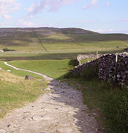
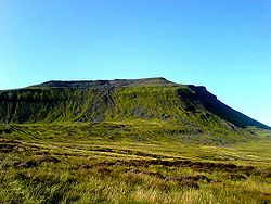
The characteristic scenery of the Dales is green upland pastures separated by dry-stone walls and grazed by sheep and cattle
. The dale
s themselves are 'U' and 'V' shaped valleys, which were enlarged and shaped by glaciers, mainly in the most recent, Devensian ice age
. The underlying rock is principally Carboniferous
limestone
(which results in a number of areas of limestone pavement
) in places interspersed with shale
and sandstone
and topped with Millstone Grit
. To the north and west of the Dent fault, the hills are principally older Silurian
and Ordovician
rocks, which make up the Howgill Fells
.
Many of the upland areas consist of heather
moorland
, used for grouse
shooting
in the months following 12 August each year (the 'Glorious Twelfth'
).
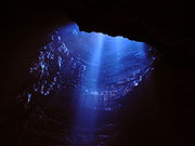 Because of the limestone that runs throughout the Dales, there are extensive cave
systems present across the area, making it one of the major areas for caving
in the UK. Many of these are open to the public for tours and for caving
.
These include:

 In 1954 an area of 1770 square kilometres (683.4 sq mi) was designated the Yorkshire Dales National Park. Most of the National Park
is in North Yorkshire
, though part lies within Cumbria
. However, the whole park lies within the historic boundaries of Yorkshire
, divided between the North Riding
and the West Riding
. The park is 50 miles (80.5 km) north east of Manchester
; Leeds and Bradford lie to the south, while Kendal is to the west and Darlington to the east. A proposed westward extension to the park would encompass much of the area between the current park and the M6 motorway
, coming close to the towns of Kirkby Lonsdale
, Kirkby Stephen
and Appleby-in-Westmorland
.This proposal to add 162 square miles to the park has now been agreed by all interested parties and merely awaits ministerial approval. For the first time the Yorkshire Dales NP and the Lake District NP will be contiguous.
Over 20,000 residents live and work in the park, which attracts over eight million visitors every year. The area has a large collection of activities for visitors. For example, many people come to the Dales for walking or exercise. The National Park is crossed by several long-distance routes including the Pennine Way
, the Dales Way
, the Coast to Coast Path and the latest national trail—the Pennine Bridleway
. Cycling is also popular and there are several cycleways.
The Park has its own museum, the Dales Countryside Museum
, housed in a conversion of the Hawes railway station
in Wensleydale
in the north area. The park has five visitor centres located in major destinations in the park. These are at:
Other places and sights within the National Park include:
Northern England
Northern England, also known as the North of England, the North or the North Country, is a cultural region of England. It is not an official government region, but rather an informal amalgamation of counties. The southern extent of the region is roughly the River Trent, while the North is bordered...
.
The area lies within the historic county boundaries
Historic counties of England
The historic counties of England are subdivisions of England established for administration by the Normans and in most cases based on earlier Anglo-Saxon kingdoms and shires...
of Yorkshire
Yorkshire
Yorkshire is a historic county of northern England and the largest in the United Kingdom. Because of its great size in comparison to other English counties, functions have been increasingly undertaken over time by its subdivisions, which have also been subject to periodic reform...
, though it spans the ceremonial counties
Ceremonial counties of England
The ceremonial counties are areas of England to which are appointed a Lord Lieutenant, and are defined by the government as counties and areas for the purposes of the Lieutenancies Act 1997 with reference to the metropolitan and non-metropolitan counties of England and Lieutenancies Act 1997...
of North Yorkshire
North Yorkshire
North Yorkshire is a non-metropolitan or shire county located in the Yorkshire and the Humber region of England, and a ceremonial county primarily in that region but partly in North East England. Created in 1974 by the Local Government Act 1972 it covers an area of , making it the largest...
, West Yorkshire
West Yorkshire
West Yorkshire is a metropolitan county within the Yorkshire and the Humber region of England with a population of 2.2 million. West Yorkshire came into existence as a metropolitan county in 1974 after the passage of the Local Government Act 1972....
and Cumbria
Cumbria
Cumbria , is a non-metropolitan county in North West England. The county and Cumbria County Council, its local authority, came into existence in 1974 after the passage of the Local Government Act 1972. Cumbria's largest settlement and county town is Carlisle. It consists of six districts, and in...
. Most of the area falls within the Yorkshire Dales National Park, created in 1954, and now one of the fifteen National parks of Britain, but the term also includes areas to the east of the National Park, notably Nidderdale
Nidderdale
Nidderdale is one of the Yorkshire Dales in North Yorkshire, England. It is the upper valley of the River Nidd, which flows south through the dale, forming several reservoirs including the Gouthwaite Reservoir, before turning east and eventually joining the River Ouse.The only town in the dale is...
.
The Dales is a collection of river valley
Valley
In geology, a valley or dale is a depression with predominant extent in one direction. A very deep river valley may be called a canyon or gorge.The terms U-shaped and V-shaped are descriptive terms of geography to characterize the form of valleys...
s and the hills among them, rising from the Vale of York
Vale of York
The Vale of York is an area of flat land in the north-east of England. The vale is a major agricultural area and serves as the main north-south transport corridor for northern England....
westwards to the hilltops of the main Pennine watershed (the British English meaning). In some places the area even extends westwards across the watershed, but most of the valleys drain eastwards to the Vale of York, into the Ouse
River Ouse, Yorkshire
The River Ouse is a river in North Yorkshire, England. The river is formed from the River Ure at Cuddy Shaw Reach near Linton-on-Ouse, about 6 miles downstream of the confluence of the River Swale with the River Ure...
and then the Humber
Humber
The Humber is a large tidal estuary on the east coast of Northern England. It is formed at Trent Falls, Faxfleet, by the confluence of the tidal River Ouse and the tidal River Trent. From here to the North Sea, it forms part of the boundary between the East Riding of Yorkshire on the north bank...
.
The word dale comes from the Nordic
North Germanic languages
The North Germanic languages or Scandinavian languages, the languages of Scandinavians, make up one of the three branches of the Germanic languages, a sub-family of the Indo-European languages, along with the West Germanic languages and the extinct East Germanic languages...
/Germanic
Germanic languages
The Germanic languages constitute a sub-branch of the Indo-European language family. The common ancestor of all of the languages in this branch is called Proto-Germanic , which was spoken in approximately the mid-1st millennium BC in Iron Age northern Europe...
word for valley (dal, tal), and occurs in valley names across Yorkshire (and Northern England generally) but the name Yorkshire Dales is generally used to refer specifically to the dales west of the Vale of York
Vale of York
The Vale of York is an area of flat land in the north-east of England. The vale is a major agricultural area and serves as the main north-south transport corridor for northern England....
and north of the West Yorkshire Urban Area
West Yorkshire Urban Area
The West Yorkshire Urban Area is a term used by the Office for National Statistics to refer to a conurbation in West Yorkshire, England, based around the cities of Leeds, Bradford and Wakefield, and the large town of Huddersfield...
. The Yorkshire Dales is served by its own radio station, Fresh Radio
Fresh Radio
Fresh Radio is a local radio station broadcasting to the Yorkshire Dales in northern England on two medium wave frequencies and three FM frequencies...
, which broadcasts programmes from studio bases in Skipton
Skipton
Skipton is a market town and civil parish within the Craven district of North Yorkshire, England. It is located along the course of both the Leeds and Liverpool Canal and the River Aire, on the south side of the Yorkshire Dales, northwest of Bradford and west of York...
and Richmond
Richmond, North Yorkshire
Richmond is a market town and civil parish on the River Swale in North Yorkshire, England and is the administrative centre of the district of Richmondshire. It is situated on the edge of the Yorkshire Dales National Park, and serves as the Park's main tourist centre...
.
Geography
Most of the dales in the Yorkshire Dales are named after their river or stream (e.g. Arkengarthdale, formed by Arkle Beck). The best-known exception to this rule is WensleydaleWensleydale
Wensleydale is the valley of the River Ure on the east side of the Pennines in North Yorkshire, England.Wensleydale lies in the Yorkshire Dales National Park – one of only a few valleys in the Dales not currently named after its principal river , but the older name, "Yoredale", can still be seen...
, which is named after the town of Wensley rather than the River Ure
River Ure
The River Ure is a river in North Yorkshire, England, approximately long from its source to the point where it changes name to the River Ouse. It is the principal river of Wensleydale, which is the only one of the Dales now named after a village rather than its river...
, although an older name for the dale is Yoredale. In fact, valley
Valley
In geology, a valley or dale is a depression with predominant extent in one direction. A very deep river valley may be called a canyon or gorge.The terms U-shaped and V-shaped are descriptive terms of geography to characterize the form of valleys...
s all over Yorkshire
Yorkshire
Yorkshire is a historic county of northern England and the largest in the United Kingdom. Because of its great size in comparison to other English counties, functions have been increasingly undertaken over time by its subdivisions, which have also been subject to periodic reform...
are called "(name of river)+dale
Valley
In geology, a valley or dale is a depression with predominant extent in one direction. A very deep river valley may be called a canyon or gorge.The terms U-shaped and V-shaped are descriptive terms of geography to characterize the form of valleys...
"—but only the more northern Yorkshire valleys (and only the upper, rural, reaches) are included in the term "The Dales". For example, the southern boundary area lies in Wharfedale
Wharfedale
Wharfedale is one of the Yorkshire Dales in England. It is the valley of the River Wharfe. Towns and villages in Wharfedale include Buckden, Kettlewell, Conistone, Grassington, Hebden, Ilkley, Burley-in-Wharfedale, Otley, Pool-in-Wharfedale, Arthington, Collingham, and Wetherby...
and Airedale
Airedale
Airedale is a geographic area in Yorkshire, England, corresponding to the river valley of the River Aire . The valley stretches from the river's origin in Malham which is in the Yorkshire Dales, down past Keighley and Bingley, through Leeds and Castleford and on to join the Humber...
. The lower reaches of these valleys are not usually included in the area and Calderdale
Calderdale
The Metropolitan Borough of Calderdale is a metropolitan borough of West Yorkshire, England, through which the upper part of the River Calder flows, and from which it takes its name...
much further south, would not normally be referred to as part of "The Dales" even though it is a dale, is in Yorkshire, and the upper reaches are as scenic and rural as many valleys further north.
Geographically, the classical Yorkshire Dales spread to the north from the market and spa town
Spa town
A spa town is a town situated around a mineral spa . Patrons resorted to spas to "take the waters" for their purported health benefits. The word comes from the Belgian town Spa. In continental Europe a spa was known as a ville d'eau...
s of Settle
Settle
Settle is a small market town and civil parish within the Craven district of North Yorkshire, England. It is served by the Settle railway station, which is located near the town centre, and Giggleswick railway station which is a mile away. It is from Leeds Bradford Airport...
, Skipton
Skipton
Skipton is a market town and civil parish within the Craven district of North Yorkshire, England. It is located along the course of both the Leeds and Liverpool Canal and the River Aire, on the south side of the Yorkshire Dales, northwest of Bradford and west of York...
, Ilkley
Ilkley
Ilkley is a spa town and civil parish in West Yorkshire, in the north of England. Ilkley civil parish includes the adjacent village of Ben Rhydding and is a ward within the metropolitan borough of Bradford. Approximately north of Bradford, the town lies mainly on the south bank of the River Wharfe...
and Harrogate
Harrogate
Harrogate is a spa town in North Yorkshire, England. The town is a tourist destination and its visitor attractions include its spa waters, RHS Harlow Carr gardens, and Betty's Tea Rooms. From the town one can explore the nearby Yorkshire Dales national park. Harrogate originated in the 17th...
in North Yorkshire, with most of the larger southern dales (e.g. Ribblesdale, Malhamdale and Airedale, Wharfedale and Nidderdale) running roughly parallel from north to south. The more northerly dales (e.g. Wensleydale
Wensleydale
Wensleydale is the valley of the River Ure on the east side of the Pennines in North Yorkshire, England.Wensleydale lies in the Yorkshire Dales National Park – one of only a few valleys in the Dales not currently named after its principal river , but the older name, "Yoredale", can still be seen...
, Swaledale and Teesdale) run generally from west to east. There are also many other smaller or lesser known dales such as Arkengarthdale, Bishopdale, Clapdale, Coverdale, Kingsdale, Littondale, Langstrothdale, Raydale, Waldendale and the Washburn Valley whose tributary streams and rivers feed into the larger valleys, and Barbondale, Dentdale, Deepdale and Garsdale which feed west to the River Lune
River Lune
The River Lune is a river in Cumbria and Lancashire, England.It is formed at Wath, in the parish of Ravenstonedale, Cumbria, at the confluence of Sandwath Beck and Weasdale Beck...
.
The characteristic scenery of the Dales is green upland pastures separated by dry-stone walls and grazed by sheep and cattle
Cattle
Cattle are the most common type of large domesticated ungulates. They are a prominent modern member of the subfamily Bovinae, are the most widespread species of the genus Bos, and are most commonly classified collectively as Bos primigenius...
. The dale
Valley
In geology, a valley or dale is a depression with predominant extent in one direction. A very deep river valley may be called a canyon or gorge.The terms U-shaped and V-shaped are descriptive terms of geography to characterize the form of valleys...
s themselves are 'U' and 'V' shaped valleys, which were enlarged and shaped by glaciers, mainly in the most recent, Devensian ice age
Ice age
An ice age or, more precisely, glacial age, is a generic geological period of long-term reduction in the temperature of the Earth's surface and atmosphere, resulting in the presence or expansion of continental ice sheets, polar ice sheets and alpine glaciers...
. The underlying rock is principally Carboniferous
Carboniferous
The Carboniferous is a geologic period and system that extends from the end of the Devonian Period, about 359.2 ± 2.5 Mya , to the beginning of the Permian Period, about 299.0 ± 0.8 Mya . The name is derived from the Latin word for coal, carbo. Carboniferous means "coal-bearing"...
limestone
Limestone
Limestone is a sedimentary rock composed largely of the minerals calcite and aragonite, which are different crystal forms of calcium carbonate . Many limestones are composed from skeletal fragments of marine organisms such as coral or foraminifera....
(which results in a number of areas of limestone pavement
Limestone pavement
A limestone pavement is a natural karst landform consisting of a flat, incised surface of exposed limestone that resembles an artificial pavement. The term is mainly used in the UK where many of these landforms have developed distinctive surface patterning resembling block of paving...
) in places interspersed with shale
Shale
Shale is a fine-grained, clastic sedimentary rock composed of mud that is a mix of flakes of clay minerals and tiny fragments of other minerals, especially quartz and calcite. The ratio of clay to other minerals is variable. Shale is characterized by breaks along thin laminae or parallel layering...
and sandstone
Sandstone
Sandstone is a sedimentary rock composed mainly of sand-sized minerals or rock grains.Most sandstone is composed of quartz and/or feldspar because these are the most common minerals in the Earth's crust. Like sand, sandstone may be any colour, but the most common colours are tan, brown, yellow,...
and topped with Millstone Grit
Millstone Grit
Millstone Grit is the name given to any of a number of coarse-grained sandstones of Carboniferous age which occur in the Northern England. The name derives from its use in earlier times as a source of millstones for use principally in watermills...
. To the north and west of the Dent fault, the hills are principally older Silurian
Silurian
The Silurian is a geologic period and system that extends from the end of the Ordovician Period, about 443.7 ± 1.5 Mya , to the beginning of the Devonian Period, about 416.0 ± 2.8 Mya . As with other geologic periods, the rock beds that define the period's start and end are well identified, but the...
and Ordovician
Ordovician
The Ordovician is a geologic period and system, the second of six of the Paleozoic Era, and covers the time between 488.3±1.7 to 443.7±1.5 million years ago . It follows the Cambrian Period and is followed by the Silurian Period...
rocks, which make up the Howgill Fells
Howgill Fells
The Howgill Fells are hills in Northern England between the Lake District and the Yorkshire Dales, lying roughly in between the vertices of a triangle made by the towns of Sedbergh, Kirkby Stephen and Tebay....
.
Many of the upland areas consist of heather
Calluna
Calluna vulgaris is the sole species in the genus Calluna in the family Ericaceae. It is a low-growing perennial shrub growing to tall, or rarely to and taller, and is found widely in Europe and Asia Minor on acidic soils in open sunny situations and in moderate shade...
moorland
Moorland
Moorland or moor is a type of habitat, in the temperate grasslands, savannas, and shrublands biome, found in upland areas, characterised by low-growing vegetation on acidic soils and heavy fog...
, used for grouse
Grouse
Grouse are a group of birds from the order Galliformes. They are sometimes considered a family Tetraonidae, though the American Ornithologists' Union and many others include grouse as a subfamily Tetraoninae in the family Phasianidae...
shooting
Shooting
Shooting is the act or process of firing rifles, shotguns or other projectile weapons such as bows or crossbows. Even the firing of artillery, rockets and missiles can be called shooting. A person who specializes in shooting is a marksman...
in the months following 12 August each year (the 'Glorious Twelfth'
Glorious Twelfth
The Glorious Twelfth is usually used to refer to 12 August, the start of the shooting season for Red Grouse and to a lesser extent the Ptarmigan in the United Kingdom. This is one of the busiest days in the shooting season, with large amounts of game being shot...
).
Tourism
The majority of visitors come to sightsee, with 75% visiting to drive around and 65% walking around. This indicates that most people visiting are there to take in the beauty of the surroundings. 26% also partake in nature trails and spotting wildlife. 45% visit an information centre while 35% visit a castle or other historic site. 94% of visitors travel in a private mode of transport, with 90% using a car. The remaining 6% travelled using public transport.Cave systems
Cave
A cave or cavern is a natural underground space large enough for a human to enter. The term applies to natural cavities some part of which is in total darkness. The word cave also includes smaller spaces like rock shelters, sea caves, and grottos.Speleology is the science of exploration and study...
systems present across the area, making it one of the major areas for caving
Caving
Caving—also occasionally known as spelunking in the United States and potholing in the United Kingdom—is the recreational pastime of exploring wild cave systems...
in the UK. Many of these are open to the public for tours and for caving
Caving
Caving—also occasionally known as spelunking in the United States and potholing in the United Kingdom—is the recreational pastime of exploring wild cave systems...
.
These include:
- Gaping Gill SystemGaping GillGaping Gill is a natural cave in North Yorkshire, England. It is one of the unmistakable landmarks on the southern slopes of Ingleborough – a deep pothole with the stream Fell Beck flowing into it...
- Alum Pot System
- Mossdale CavernsMossdale CavernsMossdale Caverns is a cave system in the Yorkshire Dales, England. It is located about north of Grassington, and east of Conistone, where the Mossdale beck disappears beneath the ground into the caves at Mossdale Scar...
- Kingsdale Caverns
- Leck Fell CavesLeck FellLeck Fell is a Site of Special Scientific Interest in Lancashire. An area of typically heavily grazed open moorland of rough grass and remnant patches of heather with little or no tree cover, it is characterised by the virtual absence of surface drainage and an extensive subterranean drainage...
- Easegill SystemEasegill SystemThe Ease Gill Cave System is the second longest, afer Ogof Draenen, and most complex cave system in Britain, with around of passages, including connections only passable by cave diving. It spans the valley between Leck Fell and Casterton Fell...
- White Scar CavesWhite Scar CavesWhite Scar Caves is a network of caves under Ingleborough in the Chapel-le-Dale valley of the Yorkshire Dales National Park in the North of England.Discovered in August 1923 by two amateur geologists, Christopher Long and J.H...
in Chapel-le-DaleChapel-le-DaleChapel-le-Dale is a hamlet in the Yorkshire Dales, England, very near Ribblehead Viaduct. The hamlet is in close proximity to Ingleborough and several potholes, the best known being Great Douk Cave. The source of the River Doe is nearby.-External links:*...
near IngletonIngleton, North YorkshireIngleton is a village and civil parish in the Yorkshire Dales in North Yorkshire, England. It is famous for walking, hiking and caving. Favourite walks are the Ingleton Waterfalls Trail and the climb up Ingleborough which is one of the famous Three Peaks. Directly from the village visitors can...
, - Ingleborough CaveIngleborough CaveIngleborough Cave is a show cave close to the village of Clapham, North Yorkshire, England adjacent to where the water from Gaping Gill resurges....
in Clapdale near ClaphamClapham, North YorkshireClapham is a village in the Craven district of North Yorkshire, England. It was previously in the West Riding of Yorkshire. It lies within the Yorkshire Dales National Park 6 miles north west of Settle just off the A65.-History:... - Stump Cross CavernsStump Cross CavernsStump Cross Caverns is a limestone cave system between Wharfedale and Nidderdale in North Yorkshire, England.-Geography:The caverns at Stump Cross are located beneath Greenhow hill, 1275 metres above sea level. Their name was taken from Stump Cross, which in ancient times marked the limit of...
near Pateley BridgePateley BridgePateley Bridge is a small market town in Nidderdale in the Borough of Harrogate, North Yorkshire, England, on the River Nidd.It has the oldest sweet shop in England and is the home of the Nidderdale Museum....
.
Yorkshire Dales National Park
National parks of England and Wales
The national parks of England and Wales are areas of relatively undeveloped and scenic landscape that are designated under the National Parks and Access to the Countryside Act 1949...
is in North Yorkshire
North Yorkshire
North Yorkshire is a non-metropolitan or shire county located in the Yorkshire and the Humber region of England, and a ceremonial county primarily in that region but partly in North East England. Created in 1974 by the Local Government Act 1972 it covers an area of , making it the largest...
, though part lies within Cumbria
Cumbria
Cumbria , is a non-metropolitan county in North West England. The county and Cumbria County Council, its local authority, came into existence in 1974 after the passage of the Local Government Act 1972. Cumbria's largest settlement and county town is Carlisle. It consists of six districts, and in...
. However, the whole park lies within the historic boundaries of Yorkshire
Yorkshire
Yorkshire is a historic county of northern England and the largest in the United Kingdom. Because of its great size in comparison to other English counties, functions have been increasingly undertaken over time by its subdivisions, which have also been subject to periodic reform...
, divided between the North Riding
North Riding of Yorkshire
The North Riding of Yorkshire was one of the three historic subdivisions of the English county of Yorkshire, alongside the East and West Ridings. From the Restoration it was used as a Lieutenancy area. The three ridings were treated as three counties for many purposes, such as having separate...
and the West Riding
West Riding of Yorkshire
The West Riding of Yorkshire is one of the three historic subdivisions of Yorkshire, England. From 1889 to 1974 the administrative county, County of York, West Riding , was based closely on the historic boundaries...
. The park is 50 miles (80.5 km) north east of Manchester
Manchester
Manchester is a city and metropolitan borough in Greater Manchester, England. According to the Office for National Statistics, the 2010 mid-year population estimate for Manchester was 498,800. Manchester lies within one of the UK's largest metropolitan areas, the metropolitan county of Greater...
; Leeds and Bradford lie to the south, while Kendal is to the west and Darlington to the east. A proposed westward extension to the park would encompass much of the area between the current park and the M6 motorway
M6 motorway
The M6 motorway runs from junction 19 of the M1 at the Catthorpe Interchange, near Rugby via Birmingham then heads north, passing Stoke-on-Trent, Manchester, Preston, Carlisle and terminating at the Gretna junction . Here, just short of the Scottish border it becomes the A74 which continues to...
, coming close to the towns of Kirkby Lonsdale
Kirkby Lonsdale
Kirkby Lonsdale is a small town and civil parish in the South Lakeland district of Cumbria, England, on the River Lune. Historically within Westmorland, it is situated south east of Kendal along the A65. The parish had a population of 1,771 recorded in the 2001 census.Notable buildings include St...
, Kirkby Stephen
Kirkby Stephen
Kirkby Stephen is a civil parish and small market town in Cumbria, in North West England which historically, is part of Westmorland. The town is located on the A685, surrounded by sparsely populated hill country, and about from the two nearest larger towns, Kendal and Penrith...
and Appleby-in-Westmorland
Appleby-in-Westmorland
Appleby-in-Westmorland is a town and civil parish in Cumbria, in North West England. It is situated within a loop of the River Eden and has a population of approximately 2,500. It is in the historic county of Westmorland, of which it was the county town. The town's name was simply Appleby, until...
.This proposal to add 162 square miles to the park has now been agreed by all interested parties and merely awaits ministerial approval. For the first time the Yorkshire Dales NP and the Lake District NP will be contiguous.
Over 20,000 residents live and work in the park, which attracts over eight million visitors every year. The area has a large collection of activities for visitors. For example, many people come to the Dales for walking or exercise. The National Park is crossed by several long-distance routes including the Pennine Way
Pennine Way
The Pennine Way is a National Trail in England. The trail runs from Edale, in the northern Derbyshire Peak District, north through the Yorkshire Dales and the Northumberland National Park and ends at Kirk Yetholm, just inside the Scottish border. The path runs along the Pennine hills, sometimes...
, the Dales Way
Dales Way
The Dales Way is an 84-mile Long Distance Footpath in Northern England, from Ilkley, West Yorkshire to Bowness-on-Windermere, Cumbria....
, the Coast to Coast Path and the latest national trail—the Pennine Bridleway
Pennine Bridleway
The Pennine Bridleway is a new National Trail under designation in Northern England.It runs roughly parallel with the Pennine Way but provides access for horseback riders and cyclists as well as walkers. The trail is around long; through Derbyshire to the South Pennines, the Mary Towneley Loop...
. Cycling is also popular and there are several cycleways.
The Park has its own museum, the Dales Countryside Museum
Dales Countryside Museum
The Dales Countryside Museum is a local museum for the Yorkshire Dales National Park in Northern England. Run by the National Park Authority, it is located in the disused Hawes railway station in the small town of Hawes at the head of Wensleydale...
, housed in a conversion of the Hawes railway station
Hawes railway station
Hawes railway station is a disused railway station that served the town of Hawes in North Yorkshire, England. It was closed in 1959 and now forms part of the Dales Countryside Museum.-History:...
in Wensleydale
Wensleydale
Wensleydale is the valley of the River Ure on the east side of the Pennines in North Yorkshire, England.Wensleydale lies in the Yorkshire Dales National Park – one of only a few valleys in the Dales not currently named after its principal river , but the older name, "Yoredale", can still be seen...
in the north area. The park has five visitor centres located in major destinations in the park. These are at:
- Aysgarth FallsAysgarth FallsAysgarth Falls are a triple flight of waterfalls, surrounded by forest and farmland, carved out by the River Ure over an almost a one-mile stretch on its descent to mid-Wensleydale in the Yorkshire Dales of England, near the village of Aysgarth...
- GrassingtonGrassingtonGrassington is a market town and civil parish in the Craven district of North Yorkshire, England.The town is situated in Wharfedale around from Bolton Abbey and is surrounded by limestone scenery...
- HawesHawesHawes is a small market town and civil parish in the Richmondshire district of North Yorkshire, England, being granted its market charter in 1699...
- MalhamMalhamMalham is a village and civil parish in the Craven district of North Yorkshire, England. Situated in the Yorkshire Dales with a population of approximately 150. The surrounding countryside is well known for its limestone pavements and other examples of limestone scenery...
- ReethReethReeth is a village in the Yorkshire Dales within the Richmondshire district of North Yorkshire, England and principal settlement of Swaledale. It is situated at the meeting point of the two most northerly of the Yorkshire Dales: Swaledale and Arkengarthdale....
Other places and sights within the National Park include:
- Bolton CastleBolton CastleBolton Castle in North Yorkshire, is located in Wensleydale in the Yorkshire Dales . The nearby village Castle Bolton takes its name from the castle. The castle is a Grade I listed building and a Scheduled Ancient Monument. The castle was damaged in the English Civil War, but much of it remains...
- ClaphamClapham, North YorkshireClapham is a village in the Craven district of North Yorkshire, England. It was previously in the West Riding of Yorkshire. It lies within the Yorkshire Dales National Park 6 miles north west of Settle just off the A65.-History:...
- Cautley SpoutCautley SpoutCautley Spout is England's highest waterfall above ground. . The broken cascade of falls tumbles a total of 650 feet down a cliff face at the head of a wild and bleak glacial valley that comes down from a high plateau called The Calf...
waterfall - Gaping GillGaping GillGaping Gill is a natural cave in North Yorkshire, England. It is one of the unmistakable landmarks on the southern slopes of Ingleborough – a deep pothole with the stream Fell Beck flowing into it...
- Hardraw ForceHardraw ForceHardraw Force is a waterfall on the Hardraw Beck in Hardraw Scar, a wooded ravine just outside the hamlet of Hardraw at the foot of Buttertubs Pass and the head of Wensleydale in the Yorkshire Dales...
- Horton in RibblesdaleHorton in RibblesdaleHorton in Ribblesdale is a small village and civil parish in the Craven district of North Yorkshire, England. It is situated in Ribblesdale on the Settle–Carlisle Railway to the west of Pen-y-ghent....
- Kisdon ForceKisdon ForceKisdon Force is a series of waterfalls on the River Swale in Swaledale, England. The falls are situated at grid reference within the Yorkshire Dales National Park in the county of North Yorkshire, 500 metres downstream from the small hamlet of Keld....
waterfall in SwaledaleSwaledaleSwaledale is one of the northernmost dales in the Yorkshire Dales National Park in northern England. It is the dale of the River Swale on the east side of the Pennines in North Yorkshire.-Geographical overview:... - Malham CoveMalham CoveMalham Cove is a natural limestone formation 1 km north of the village of Malham, North Yorkshire, England. A well-known beauty spot, it is a large, curved limestone cliff at the head of a valley, with a fine area of limestone pavement at the top....
and Gordale ScarGordale ScarGordale Scar is a dramatic limestone ravine 1 mile or 1.5 km NE of Malham, North Yorkshire, England. It contains two waterfalls and has overhanging limestone cliffs over 100 metres high. The gorge was formed by water from melting glaciers... - SedberghSedberghSedbergh is a small town in Cumbria, England. It lies about east of Kendal and about north of Kirkby Lonsdale. The town sits just within the Yorkshire Dales National Park...
- SettleSettleSettle is a small market town and civil parish within the Craven district of North Yorkshire, England. It is served by the Settle railway station, which is located near the town centre, and Giggleswick railway station which is a mile away. It is from Leeds Bradford Airport...
- Settle and Carlisle RailwaySettle-Carlisle RailwayThe Settle–Carlisle Line is a long main railway line in northern England. It is also known as the Settle and Carlisle. It is a part of the National Rail network and was constructed in the 1870s...
including the Ribblehead ViaductRibblehead ViaductRibblehead Viaduct is a railway viaduct across the valley of the River Ribble at Ribblehead, in North Yorkshire, northern England. The viaduct is a Grade II* listed building and a Scheduled Ancient Monument.-Description:... - The Yorkshire three peaksYorkshire three peaksThe mountains of Whernside , Ingleborough and Pen-y-ghent are collectively known as the Three Peaks. The peaks, which form part of the...
List of Dales
- AiredaleAiredaleAiredale is a geographic area in Yorkshire, England, corresponding to the river valley of the River Aire . The valley stretches from the river's origin in Malham which is in the Yorkshire Dales, down past Keighley and Bingley, through Leeds and Castleford and on to join the Humber...
- ArkengarthdaleArkengarthdaleArkengarthdale is a dale, or valley, on the east side of the Pennines in North Yorkshire, England. Running roughly northwest–southeast, it is the valley of the Arkle Beck, and is the northernmost of the Yorkshire Dales...
- BarbondaleBarbon BeckBarbon Beck is a small river in Cumbria.Rising at Weather Ling Hill, where it is known as Barkin Beck, the stream passes southwest down Barbondale to Fell House, where, joined by Aygill , now known as Barbon Beck, it takes a westerly course, past Barbon Manor and through the...
- BirkdaleBirkdale, North YorkshireBirkdale is a dale in the Yorkshire Dales National Park, in North Yorkshire, England. The dale itself is very small compared to some of the other Yorkshire dales. It has one small hamlet called Keld. The dale itself is a tributary dale to Swaledale, another dale in the Yorkshire Dales...
- Bishopdale
- Chapel-le-DaleChapel-le-DaleChapel-le-Dale is a hamlet in the Yorkshire Dales, England, very near Ribblehead Viaduct. The hamlet is in close proximity to Ingleborough and several potholes, the best known being Great Douk Cave. The source of the River Doe is nearby.-External links:*...
- CoverdaleCoverdale (dale)Coverdale is a dale in the far east of the Yorkshire Dales, North Yorkshire, England. It gets its name from the River Cover and the small settlement of Coverham, which is situated on its Northern edge...
- DentdaleDentdaleThe valley of Dentdale in Cumbria and North Yorkshire, England, takes its name from the village of Dent.The Dent Fault cuts across the valley close to the village of Gawthrop, marking a geological boundary between the Carboniferous Limestone of Deepdale and the Craven Dales to the south and the...
- GarsdaleGarsdaleGarsdale is a civil parish occupying a narrow populated valley in Cumbria, England. It is on the western slopes of the Pennines, between Baugh Fell to the north, and Rise Hill to the south. The main hamlet, called “The Street”, lies on the A684 road, east of Sedbergh, and west of Hawes...
- LangstrothdaleLangstrothdaleLangstrothdale is a valley in the Yorkshire Dales in North Yorkshire, England. The uppermost course of the River Wharfe runs through it, but Wharfedale does not begin until the Wharfe meets Cray Gill, downstream of Hubberholme....
- LittondaleLittondaleLittondale is a dale in the Craven district of the non-metropolitan county of North Yorkshire, England. It comprises the main settlements of Hawkswick, Arncliffe, Litton, Foxup and Halton Gill, and farmhouses that date from the 17th century...
- Kingsdale
- MalhamMalhamMalham is a village and civil parish in the Craven district of North Yorkshire, England. Situated in the Yorkshire Dales with a population of approximately 150. The surrounding countryside is well known for its limestone pavements and other examples of limestone scenery...
dale - NidderdaleNidderdaleNidderdale is one of the Yorkshire Dales in North Yorkshire, England. It is the upper valley of the River Nidd, which flows south through the dale, forming several reservoirs including the Gouthwaite Reservoir, before turning east and eventually joining the River Ouse.The only town in the dale is...
- Ribblesdale
- SwaledaleSwaledaleSwaledale is one of the northernmost dales in the Yorkshire Dales National Park in northern England. It is the dale of the River Swale on the east side of the Pennines in North Yorkshire.-Geographical overview:...
- WensleydaleWensleydaleWensleydale is the valley of the River Ure on the east side of the Pennines in North Yorkshire, England.Wensleydale lies in the Yorkshire Dales National Park – one of only a few valleys in the Dales not currently named after its principal river , but the older name, "Yoredale", can still be seen...
- WharfedaleWharfedaleWharfedale is one of the Yorkshire Dales in England. It is the valley of the River Wharfe. Towns and villages in Wharfedale include Buckden, Kettlewell, Conistone, Grassington, Hebden, Ilkley, Burley-in-Wharfedale, Otley, Pool-in-Wharfedale, Arthington, Collingham, and Wetherby...