
Bob Graham Round
Encyclopedia
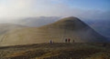
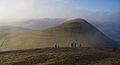
The Bob Graham Round is a circuit of 42 fell
s in the English Lake District
, including the 3000 feet (914.4 m) peaks of Skiddaw
, Helvellyn
, Scafell and Scafell Pike
. The round is named after Bob Graham (1889–1966), a Keswick guest-house owner, who in 1932 set the record for the number of Lakeland fells traversed in 24 hours which he held for twenty eight years until its repeat, with Graham's encouragement, by Alan Heaton in a quicker time in 1960.
Any contender who traverses the fells of Bob Graham's round within 24 hours is eligible for membership of the Bob Graham Club. While the club keeps to a low profile policy in the spirit of Bob Graham's reputation as a quiet, modest individual, its primary role being record keeper of attempts and successful rounds, members encourage and support contenders. Despite Graham's understatement that the round is achievable by anyone of "average" fitness, it is considered by many as one of the most demanding tests of endurance for an amateur athlete or mountaineer.
's Lakeland guidebook:
On 12–13 June 1932 the Lakeland
fell runner
Bob Graham set the peak bagging
record of 42 Lakeland peaks in just under 24 hours. Bob Graham's Round was not repeated again until 1960. Depending on the line taken, the length of the route is between 63 miles (101.4 km) and 66 miles (106.2 km) with approximately 8200 metres (26,902.9 ft) of ascent and descent. Several 20th Century sources (including the 42 Peaks booklet) erroneously state the distance to be 72 miles (115.9 km).
The Lakeland writer Harry Griffin
is credited with rekindling interest in Graham's record in the late 1950s, at a time when the veteran walker Dr Barbara Moore
had gained much publicity for doing the John o'Groats to Land's End walk. Griffin went on, with Fred Rogerson, to found the Bob Graham Club, which meets bi-annually in the Lake District.
Alan Heaton became the first to repeat and better Graham's round in 1960, though the tops Heaton chose were not the same as Graham had visited. Graham included:
These were replaced by:
It is these along with the other 38 tops that is now called the "Bob Graham Round" and are listed below.
The Bob Graham Round is now a standard fell-runner's test-piece: having been successfully completed by 1710 people at the end of 2011. Although it is possible to complete the basic round at a fast walking pace, most contenders choose to run at least the level ground. Solo rounds have been accomplished but, again, most contenders are accompanied by at least one runner in support: a requirement for acceptance by the Bob Graham Club. The vast majority of attempts are undertaken close to mid summer to make use of maximum daylight. Nonetheless, as of March 2011, twenty three individuals have successfully completed a winter round of the standard circuit.
The Bob Graham cairn http://www.leaney.org/lake_district_walk_photo.php?walk_id=682&photo=20070415s&thumb=Y, commemorating both Graham and his feat, stands just below Ashness Bridge
(grid reference NY270196), quite close to the road. Note that this memorial erroneously gives the date of Graham's round as 13–14 June.
. Predicted times for each stage of the round can be determined using an adaptation of Naismith's Rule
.
The fastest ladies round is:
Building on the basic Bob Graham Round, later runners raised the number of peaks traversed within 24 hours still further:
The ladies record is:
Graham is believed to have chosen 42 peaks as his age at that time - he had attempted a round of 41 peaks the previous year and narrowly failed to complete it in 24 hours. Several later runners have successfully attempted 50 peaks at 50, and 55 peaks at 55. Notable achievements are:
Fell
“Fell” is a word used to refer to mountains, or certain types of mountainous landscape, in Scandinavia, the Isle of Man, and parts of northern England.- Etymology :...
s in the English Lake District
Lake District
The Lake District, also commonly known as The Lakes or Lakeland, is a mountainous region in North West England. A popular holiday destination, it is famous not only for its lakes and its mountains but also for its associations with the early 19th century poetry and writings of William Wordsworth...
, including the 3000 feet (914.4 m) peaks of Skiddaw
Skiddaw
Skiddaw is a mountain in the Lake District National Park in England. With a summit at 931 m above sea level it is the fourth highest mountain in England. It lies just north of the town of Keswick, Cumbria, and dominates the skyline in this part of the northern lakes...
, Helvellyn
Helvellyn
Helvellyn is a mountain in the English Lake District, the apex of the Eastern Fells. At above sea level, it is the third highest peak in both the Lake District and England...
, Scafell and Scafell Pike
Scafell Pike
Scafell Pike is the highest mountain in England at . It is located in Lake District National Park sometimes confused with the neighbouring Sca Fell, to which it is connected by the col of Mickledore...
. The round is named after Bob Graham (1889–1966), a Keswick guest-house owner, who in 1932 set the record for the number of Lakeland fells traversed in 24 hours which he held for twenty eight years until its repeat, with Graham's encouragement, by Alan Heaton in a quicker time in 1960.
Any contender who traverses the fells of Bob Graham's round within 24 hours is eligible for membership of the Bob Graham Club. While the club keeps to a low profile policy in the spirit of Bob Graham's reputation as a quiet, modest individual, its primary role being record keeper of attempts and successful rounds, members encourage and support contenders. Despite Graham's understatement that the round is achievable by anyone of "average" fitness, it is considered by many as one of the most demanding tests of endurance for an amateur athlete or mountaineer.
History of the Round
The development of progressively lengthier and more competitive rounds of the Lakeland fells is chronicled in the Bob Graham Club's Story of the Bob Graham Round, and in the fell-walking section of M. J. B. BaddeleyM. J. B. Baddeley
Mountford John Byrde Baddeley was a distinguished English guidebook writer of the late 19th and early 20th century. His guides appeared in the 'Thorough Guide' series, edited by Baddeley and his colleague, Charles Slegg Ward, and included guides to Scotland , Devon and Cornwall Mountford John...
's Lakeland guidebook:
- 1864: the Reverend J.M. Elliott of Cambridge traversed the summits around the head of Wasdale in 8.5 hours
- 1870: Thomas Watson of Darlington covered 48 miles (77.2 km) with over 10000 feet (3,048 m) of ascent in 20 hours
- 1902: S.B. Johnson of Carlisle completed a 70 miles (112.7 km), 18000 feet (5,486.4 m) round in 22.5 hours
- 1905: Dr Wakefield of Keswick completed the same round in 22h7m (recorded in The Sedberghian)
- 1920: Eustace Thomas, at age 54, covered the same round in 21h25m
On 12–13 June 1932 the Lakeland
Lake District National Park
The Lake District National Park is located in the north-west of England and is the largest of the English National Parks and the second largest in the United Kingdom. It is in the central and most-visited part of the Lake District....
fell runner
Fell running
Fell running, also known as mountain running and hill running, is the sport of running and racing, off road, over upland country where the gradient climbed is a significant component of the difficulty...
Bob Graham set the peak bagging
Peak bagging
Peak bagging is an activity in which hillwalkers and mountaineers attempt to reach the summit of some collection of peaks, usually those above some height in a particular region, or having a particular feature.Peak bagging can be distinguished from highpointing...
record of 42 Lakeland peaks in just under 24 hours. Bob Graham's Round was not repeated again until 1960. Depending on the line taken, the length of the route is between 63 miles (101.4 km) and 66 miles (106.2 km) with approximately 8200 metres (26,902.9 ft) of ascent and descent. Several 20th Century sources (including the 42 Peaks booklet) erroneously state the distance to be 72 miles (115.9 km).
The Lakeland writer Harry Griffin
Harry Griffin
Arthur Harry Griffin , usually known in print as A. Harry Griffin, was a British journalist and mountaineer...
is credited with rekindling interest in Graham's record in the late 1950s, at a time when the veteran walker Dr Barbara Moore
Barbara Moore (vegetarian)
Dr. Barbara Moore was a Russian-born health enthusiast who gained celebrity in the early 1960s for her long-distance walking....
had gained much publicity for doing the John o'Groats to Land's End walk. Griffin went on, with Fred Rogerson, to found the Bob Graham Club, which meets bi-annually in the Lake District.
Alan Heaton became the first to repeat and better Graham's round in 1960, though the tops Heaton chose were not the same as Graham had visited. Graham included:
- High White Stones
- Hanging Knotts
- Looking Stead
- High Snab Bank
These were replaced by:
- Whiteside
- Helvellyn Lower Man
- Ill Crag
- Broad Crag
It is these along with the other 38 tops that is now called the "Bob Graham Round" and are listed below.
The Bob Graham Round is now a standard fell-runner's test-piece: having been successfully completed by 1710 people at the end of 2011. Although it is possible to complete the basic round at a fast walking pace, most contenders choose to run at least the level ground. Solo rounds have been accomplished but, again, most contenders are accompanied by at least one runner in support: a requirement for acceptance by the Bob Graham Club. The vast majority of attempts are undertaken close to mid summer to make use of maximum daylight. Nonetheless, as of March 2011, twenty three individuals have successfully completed a winter round of the standard circuit.
The Bob Graham cairn http://www.leaney.org/lake_district_walk_photo.php?walk_id=682&photo=20070415s&thumb=Y, commemorating both Graham and his feat, stands just below Ashness Bridge
Ashness Bridge
Ashness Bridge is a traditional stone-built bridge on the single-track road from the Borrowdale road to Watendlath, in the English Lake District...
(grid reference NY270196), quite close to the road. Note that this memorial erroneously gives the date of Graham's round as 13–14 June.
The Bob Graham Route
The round may be attempted either clockwise or anti-clockwise, provided that the start and finish is at the Moot Hall, KeswickKeswick, Cumbria
Keswick is a market town and civil parish within the Borough of Allerdale in Cumbria, England. It had a population of 4,984, according to the 2001 census, and is situated just north of Derwent Water, and a short distance from Bassenthwaite Lake, both in the Lake District National Park...
. Predicted times for each stage of the round can be determined using an adaptation of Naismith's Rule
Naismith's Rule
Naismith's Rule is a rule of thumb that helps in the planning of a walking or hiking expedition by calculating how long it will take to walk the route, including ascents. The rule was devised by William W. Naismith, a Scottish mountaineer, in 1892...
.
| Summit Sequence |
Location |
|---|---|
| Start and Finish Line | Moot Hall, Keswick |
| 1 | Skiddaw Skiddaw Skiddaw is a mountain in the Lake District National Park in England. With a summit at 931 m above sea level it is the fourth highest mountain in England. It lies just north of the town of Keswick, Cumbria, and dominates the skyline in this part of the northern lakes... |
| 2 | Great Calva Great Calva Great Calva is a fell in the Lake District, England. It is in the Northern Fells, lying roughly at the centre of this region of high ground. As a result it is distant from roads and quite remote by Lakeland standards... |
| 3 | Blencathra Blencathra Blencathra, also known as Saddleback, is one of the most northerly mountains in the English Lake District. It has six separate fell tops, of which the highest is the Hallsfell Top.-Name:... |
| Road Crossing | Threlkeld Threlkeld Threlkeld is a village and civil parish in the north of the Lake District in Cumbria, England, to the east of Keswick. It lies at the southern foot of Blencathra, one of the more prominent fells in the northern Lake District, and to the north of the River Glenderamackin.Historically a part of... |
| 4 | Clough Head Clough Head Clough Head is a fell in the English Lake District. It is the northernmost top of the Helvellyn range in the Eastern Fells, standing to the south of Threlkeld and the A66.-Topography:... |
| 5 | Great Dodd Great Dodd Great Dodd is a fell in the English Lake District. It stands on the main spine of the Helvellyn range in the Eastern Fells, between the Vale of St John and Dockray.-Topography:... |
| 6 | Watson's Dodd Watson's Dodd Watson's Dodd is a fell in the English Lake District. It forms part of the Helvellyn range in the Eastern Fells. This chain of hills runs north-south and, in the vicinity of Watson's Dodd, forms the watershed between the Thirlmere and Ullswater catchments.... |
| 7 | Stybarrow Dodd Stybarrow Dodd Stybarrow Dodd is a fell in the English Lake District. It stands on the main spine of the Helvellyn range in the Eastern Fells, situated between Thirlmere and the Ullswater catchment.-Topography:... |
| 8 | Raise |
| 9 | White Side White Side White Side is a fell in the English Lake District. It is situated to the east of Thirlmere and to the west of Glenridding valley. This places White Side in the Helvellyn range of the Eastern Fells, with Raise to the north and Helvellyn Lower Man to the south, both of which are of greater... |
| 10 | Lowerman |
| 11 | Helvellyn Helvellyn Helvellyn is a mountain in the English Lake District, the apex of the Eastern Fells. At above sea level, it is the third highest peak in both the Lake District and England... |
| 12 | Nethermost Pike Nethermost Pike Nethermost Pike is a fell in Cumbria, England, and a part of the Lake District. At it is the second highest Wainwright in the Helvellyn range, the tallest of which is Helvellyn itself. It is located close to the southern end of the ridge, with Helvellyn to the north, and High Crag and Dollywaggon... |
| 13 | Dollywagon Pike |
| 14 | Fairfield Fairfield (Lake District) Fairfield is a fell in the English Lake District. It is the highest of a group of hills in the Eastern Fells, standing to the south of the Helvellyn range.-Topography:... |
| 15 | Seat Sandal Seat Sandal Seat Sandal is a fell in the English Lake District, it is situated four kilometers north of the village of Grasmere from where it is very well seen... |
| Road Crossing | Dunmail Raise Dunmail Raise Dunmail Raise is a hill in the English Lake District, the highest point of a pass on the Keswick-Kendal road, the A591, to the south of Thirlmere reservoir on the way to Grasmere, in the Lake District National Park... |
| 16 | Steel Fell Steel Fell Steel Fell is a fell in the English Lake District, lying between Thirlmere and Grasmere. It is triangular in plan, the ridges running north, west and south east... |
| 17 | Calf Crag Calf Crag Calf Crag is a fell in the English Lake District, on the eastern side of the High Raise massif.-Topography:The spine of the Central Fells runs on a north-south axis with the highpoint at High Raise... |
| 18 | High Raise High Raise (Langdale) High Raise is a fell in the Central Fells of the English Lake District not to be confused with another High Raise situated in the Far Eastern Fells... |
| 19 | Sergeant Man Sergeant Man Sergeant Man is a fell in the English Lake District. It is properly a secondary summit of High Raise, but is given a separate chapter by Alfred Wainwright in his third Pictorial Guide nonetheless, as it "is so prominent an object and offers so compelling a challenge"... |
| 20 | Thunacar Knott Thunacar Knott Thunacar Knott is a fell in the central part of the English Lake District in the county of Cumbria.-Topography:The main spine of the Central Fells runs south from Bleaberry Fell to High Raise, before turning sharply east en route for Blea Rigg and Loughrigg Fell. A secondary ridge projects... |
| 21 | Harrison Stickle Harrison Stickle Harrison Stickle is a fell in the central part of the English Lake District, situated above Great Langdale. The fell is one of the three fells which make up the picturesque Langdale Pikes, the others being Pike of Stickle and Loft Crag. Together they make up one of the most picturesque, and... |
| 22 | Pike O' Stickle Pike of Stickle Pike of Stickle, also known as Pike O’ Stickle, is a fell in the English Lake District. It reaches a height of 709 metres and is situated in the central part of the national park in the valley of Great Langdale... |
| 23 | Rossett Pike Rossett Pike Rossett Pike is a fell in the English Lake District. It is located at the head of Mickleden, one of two tributary valleys of Great Langdale.-Topography:... |
| 24 | Bowfell Bowfell Bowfell is a pyramid-shaped mountain lying at the heart of the English Lake District, in the Southern Fells area. It is the sixth highest mountain in the lakes and one of the most popular of the Lake District fells... |
| 25 | Esk Pike Esk Pike Esk Pike is a fell in the English Lake District, one of the great cirque of hills forming the head of Eskdale.-Topography:The Southern Fells include the highest ground in England, a horseshoe which begins with Scafell and Scafell Pike in the west and then curves around the north of Upper Eskdale to... |
| 26 | Great End Great End Great End is the most northerly mountain in the Scafell chain, in the English Lake District. From the south it is simply a lump continuing this chain.... |
| 27 | Ill Crag Ill Crag Ill Crag is a fell in the English Lake District. By some counts it is the fourth highest peak in England, although many people, including Alfred Wainwright, consider it to be a subsidiary summit of Scafell Pike... |
| 28 | Broad Crag Broad Crag Broad Crag is a fell in the English Lake District. By some counts, it is the fifth highest peak in England at a height of 934 metres .-Topography:It forms part of the Scafell chain, and lies about northeast of Scafell Pike... |
| 29 | Scafell Pike Scafell Pike Scafell Pike is the highest mountain in England at . It is located in Lake District National Park sometimes confused with the neighbouring Sca Fell, to which it is connected by the col of Mickledore... |
| 30 | Scafell Sca Fell Sca Fell is a mountain in the English Lake District. Its height of 964 metres makes it the second-highest mountain in England after Scafell Pike, from which it is separated by the col of Mickledore.... |
| Road Crossing | Wasdale Campsite Wasdale Head Wasdale Head is a small agricultural village in the Lake District National Park in Cumbria, England. The village claims to be home of the highest mountain , deepest lake , smallest church and biggest liar in England... |
| 31 | Yewbarrow Yewbarrow Yewbarrow is a fell in the English Lake District which lies immediately north of the head of Wast Water. It is 628 metres high and in shape resembles the upturned hull of a boat or a barrow. Yewbarrow is on the left in the classic view of Great Gable and Wast Water.The top of Stirrup Crag... |
| 32 | Red Pike Red Pike (Wasdale) Red Pike is a fell in the English Lake District. It is 826 m or high and lies due north of Wast Water. It is often climbed as part of the Mosedale Horseshoe, a walk which also includes Pillar.... |
| 33 | Steeple Steeple (Lake District) Steeple is a fell in the English Lake District. It is situated in the mountainous area between Ennerdale and Wasdale and reaches a height of 819 metres . Steeple is really part of Scoat Fell, being just the rocky northern projection of that fell, however because of its prominent peak and steep... |
| 34 | Pillar Pillar (Lake District) Pillar is a mountain in the western part of the English Lake District. Situated between the valleys of Ennerdale to the north and Wasdale to the south, it is the highest point of the Pillar group . At 892 metres it is the eighth highest mountain in the Lake District... |
| 35 | Kirk Fell Kirk Fell Kirk Fell is a fell in the Western part of the English Lake District. It is situated between Great Gable and Pillar on the long ring of fells surrounding the valley of Ennerdale, and also stands over Wasdale to the south... |
| 36 | Great Gable Great Gable Great Gable is a mountain lying at the very heart of the English Lake District, appearing as a pyramid from Wasdale , but as a dome from most other directions. It is one of the most popular of the Lakeland fells, and there are many different routes to the summit... |
| 37 | Green Gable Green Gable Green Gable is a fell in the English Lake District often traversed by walkers on route to its more famous neighbour Great Gable. It can be ascended from Honister Pass, Seathwaite in Borrowdale, or Ennerdale... |
| 38 | Brandreth Brandreth Brandreth is a fell in the English Lake District. It stands between Great Gable and Haystacks in the Western Fells.-Topography:The Western Fells occupy a triangular sector of the Lake District, bordered by the River Cocker to the north east and Wasdale to the south east. Westwards the hills... |
| 39 | Grey Knotts Grey Knotts Grey Knotts is a fell in the English Lake District, it is situated one kilometre south of the B5289 road as it crosses the Honister Pass, it is well seen from mid Borrowdale as it rises above Seatoller... |
| Road Crossing | Honister Pass Honister Pass The Honister Pass, also known as Honister Hause, is a mountain pass in the English Lake District. It is located on the B5289 road, linking Seatoller, in the valley of Borrowdale, to Gatesgarth at the southern end of Buttermere... |
| 40 | Dale Head Dale Head Dale Head is a fell in the northwestern sector of the Lake District, in northern England. It is 753 metres or 2,470 feet above sea level and stands immediately north of Honister Pass, the road between Borrowdale and Buttermere.-Topography:... |
| 41 | Hindscarth Hindscarth Hindscarth is a mountain between the valleys of Buttermere and Newlands, in the north-western part of the English Lake District. The fell's name is derived from two words from the Old Norse language, Hind and Skarth, and means the pass used by the red deer.-Topography:The North Western Fells occupy... |
| 42 | Robinson Robinson (Lake District) thumb|Robinson seen from the [[Ard Crags]] ridge, with Hindscarth to the leftRobinson is a fell in the English Lake District, its southern slopes descending to Buttermere, while its northern side is set in the Newlands Valley... |
| Start and Finish Line | Moot Hall, Keswick |
Record Circuits
The record for the fastest round of the standard 42 tops was reduced progressively:- 1960: Alan Heaton - 22h18
- 1971: Peter Walkington - 20h43m
- 1973: Bill SmithBill Smith (fell runner)Bill Smith was a notable fell runner and well-known author on the sport. He was considered a "legend" in the fell-running community."The word legend is all too often rolled out in sporting circles...
& Boyd Millen - 20h38 - 1976: John North - 19h48
- 1976: Billy Bland - 18h50
- 1977: Mike Nicholson - 17h45m
- 1982: Billy BlandBilly Bland (runner)Billy Bland was one of the most prominent fell runners from the mid-1970s until the late 1980s, and is arguably the best long-distance fell runner in the history of the sport.He was born in 1947 in Borrowdale in the Lake District....
- 13h53m
The fastest ladies round is:
- 1991: Ann Stentiford - 18hr49m
Building on the basic Bob Graham Round, later runners raised the number of peaks traversed within 24 hours still further:
- 1962: Alan Heaton - 54 peaks in 23h48m
- 1963: Eric Beard - 56 peaks, involving 88 miles (141.6 km) with 34000 feet (10,363.2 m) of ascent in 23h35m
- 1964: Alan Heaton - 60 peaks in 23h34m
- 1971: Joss NaylorJoss NaylorJoss Naylor MBE is an English fell runner. Naylor is a sheep farmer, living in the English Lake District...
- 61 peaks in 23h37m - 1972: Joss NaylorJoss NaylorJoss Naylor MBE is an English fell runner. Naylor is a sheep farmer, living in the English Lake District...
- 63 peaks in 23h35m - 1975: Joss NaylorJoss NaylorJoss Naylor MBE is an English fell runner. Naylor is a sheep farmer, living in the English Lake District...
- 72 peaks involving over 100 miles (160.9 km) and 37000 feet (11,277.6 m) of ascent in 23h20m - 1988: Mark McDermott - 76 peaks in 23h26m
- 1997: Mark Hartell - 77 peaks in 23h47m
The ladies record is:
- 2011: Nicky Spinks - 64 peaks in 23h15m
Graham is believed to have chosen 42 peaks as his age at that time - he had attempted a round of 41 peaks the previous year and narrowly failed to complete it in 24 hours. Several later runners have successfully attempted 50 peaks at 50, and 55 peaks at 55. Notable achievements are:
- 1997: Joss NaylorJoss NaylorJoss Naylor MBE is an English fell runner. Naylor is a sheep farmer, living in the English Lake District...
attempted 60 peaks at age 60 over 36 hours (first to last peak) to raise money for Multiple Sclerosis research - 2005: Yiannis TridimasYiannis TridimasYiannis Tridimas is a renowned long-distance fell runner, noted as being the first and only 60 year old to have completed an extended version of the Bob Graham Round, covering 60 peaks in under 24 hours...
completed 60 peaks at age 60, in 23h52m - 2006: Joss NaylorJoss NaylorJoss Naylor MBE is an English fell runner. Naylor is a sheep farmer, living in the English Lake District...
completed 70 peaks at age 70, covering more than 50 miles and ascending more than 25,000 feet, in under 21 hours
See also
- South Wales TraverseSouth Wales TraverseThe South Wales Traverse is a long distance fell running challenge across the mountains of South Wales. It is a linear route of taking in some 31 summits over high, giving about of ascent. The aim is for participants to complete the route, on foot, within 24 hours...
sometimes considered the South Wales equivalent of the Bob Graham Round. - Paddy Buckley A similar round in the mountains of SnowdoniaSnowdoniaSnowdonia is a region in north Wales and a national park of in area. It was the first to be designated of the three National Parks in Wales, in 1951.-Name and extent:...
. - Ramsay RoundRamsay RoundThe Ramsay Round is a long distance fell running challenge near Fort William, Scotland. The route is a circuit of 58 miles, taking in 24 summits with a total climb of around 28,500 feet. Ben Nevis, Great Britain's highest peak, is included in the route along with 22 other Munros...
The Scottish equivalent of the Bob Graham taking in 24 Munros on the ridges of The Grey Corries and the Mamores. - The Wicklow Round The Irish equivalent taking in 26 mountains in the Wicklow mountains region.
External links
- Bob Graham 24 Hour Club Official site of the Bob Graham Round club
- Bob Graham Round Bob Wightman's Bob Graham Round webpages
- The Bob Graham Round Another site for enthusiasts including further statistics (now part of the Bob Graham 24 Hour Club's website)
- Fell & Rock Climbing Club of the English Lake District FRCCFell & Rock Climbing ClubThe Fell & Rock Climbing Club of the English Lake District is the senior climbing club covering the English Lake District. It was founded in 1906–1907 and, amongst its other activities, publishes the rock climbing guides to the area. It owns many of the early climbing photographs The Fell &...
site, giving long walks and runs in the English Lakes - The Fell Runners Association organizers in the UKUnited KingdomThe United Kingdom of Great Britain and Northern IrelandIn the United Kingdom and Dependencies, other languages have been officially recognised as legitimate autochthonous languages under the European Charter for Regional or Minority Languages...
with links to regions, events and clubs