
Wrights, California
Encyclopedia
Wrights, California is a locale in Santa Clara County, California
in the Santa Cruz Mountains
, at , near Summit Road, east of State Route 17. It is located on the north bank of Los Gatos Creek
.
The National Weather Service
maintained a cooperative weather station on the site of Wrights until May 31, 1986, which recorded rainfall and snowfall. The weather station was 1600 feet (487.7 m) above sea level. The location is on the San Andreas Fault
, according to the U.S. Geological Survey, and it experienced considerable damage in the 1906 San Francisco earthquake
. Geologists observed a lateral displacement of 4.6 feet (1.4 m) at Wrights. Wrights is now considered a ghost town
.
Wrights is one of a number of ghost towns in the Santa Cruz Mountains that flourished during the last half of the nineteenth century. Laurel
, Wrights, Glenwood
, and Clems
declined when the Los Gatos
-Santa Cruz
railroad ceased operations in March 1940. Later in 1940, Patchen
was bypassed and isolated by the construction of State Route 17; since the late 1960s it has been a Christmas tree ranch. Alma
and Lexington
were submerged in Lexington Reservoir in 1952, along State Route 17 above Los Gatos.
 In the 1870s a toll road was built over the mountains from Los Gatos to Santa Cruz that was utilized by stagecoaches. Then, a narrow gauge railroad from Alameda was constructed along the same route, beginning in 1877, by San Francisco capitalists James Fair and Alfred E. Davis, who headed the South Pacific Coast Railroad (SPCRR). One of the stops along the line, just below the summit of the Santa Cruz Mountains, was adjacent to the property of James Richards Wright, who had a residence/hotel known as Arbor Villa in Burrell
near the summit, and he maintained commercial orchards of fruit trees and grapes. The small community that sprouted around this stop on the railroad became known as Wright's Station, or simply Wrights. The Rev. Wright was the patriarch of a large family that had moved to California from Ohio and the younger brother of the well-known abolitionist Elizur Wright. One of his sons, Frank Vincent Wright, later married Susie Davis, the daughter of SPCRR president Alfred Davis, and another son, Sumner Banks Wright, moved to southern California and established a town in the San Bernardino mountains known as Wrightwood, today a ski resort.
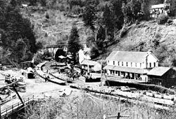
A post office was established at Wrights in 1879, and the railroad was completed in 1880 from Los Gatos, along the Los Gatos Creek, to Wrights Station, about a mile east of Patchen. During the construction of the main railroad tunnel (between Wrights and Laurel
), a strong flow of natural gas
was encountered, and an explosion followed, which resulted in the death of thirty-two Chinese
workers. The main leak was subsequently stopped, but gas continued to escape in small quantities. The extent of the supply was unknown. U.S. Geological Survey maps from 1919 show the railroad running from Los Gatos to Santa Cruz, with stops in Alma
, Wrights, Laurel
, Glenwood
, Clems
, Zayante
, Eccles
, Felton
, and Scotts Valley
. There were a series of tunnels, including a 6200 feet (1,889.8 m) tunnel between Wright and Laurel, most of which were later blocked when the railroad ceased opeations. Wrights itself had a benchmark
elevation of 896 feet (273.1 m).
Wrights Station was an important shipping point for extensive fruit growing areas in the Santa Cruz mountains. By the 1890s, there were about 3200 acres (12.9 km²) under cultivation. The soil consists largely of disintegrated sandstone
and clay
, and has the appearance, particularly on the hilltops, of the "white ash
" soil of the Fresno
raisin
district.
Vineyards were planted, providing grapes for commercial wine
producers, such as Almaden Vineyards
and Paul Masson
. There was a thriving timber
industry, too, utilizing the redwoods of the Santa Cruz Mountains. All utilized the railroad. Wrights Station was one of the small settlements that grew up along the railroad.
Alice Matty and her father, Antone, came to Wrights in 1880 from San Francisco. Her father was originally from the Maritime Alps region of France. Antone Matty worked in the general store for eight years. An overheated stove in the town's hotel started a fire in 1885 that leveled the entire settlement. While Wrights was being rebuilt, Antone ran the store from a boxcar parked on the railroad siding.
In 1887, journalist Josephine McCracken visited Wrights (as it was commonly called), reporting the community had "a depot, hotel, store, post office, blacksmith shop, besides a number of decidedly ugly and disgraceful-looking Chinese stores and wash houses. Fir-crowned mountains frowned down upon it, and the hideous black mouth of the great tunnel close by is always wide open, with the evident and determined intention of swallowing up the train — engine, cars, and all — as it approached from the San Francisco side."
By 1888, Antone Matty had saved enough money to buy the store, and by 1896 he owned the town. Since the Matty family had six children, Matty helped to organize a school district, and soon the town had a school. The Wright School was a shingle-walled building with a belfry, and was in operation until 1928. Matty became a member of the Santa Clara Valley
Pioneer Association, and later joined the Sempervirens Club
, a conservation organization devoted to saving the redwoods.
Southern Pacific Railroad
bought the narrow gauge SPCRR railroad and decided to take advantage of a craze for picnic excursion trains. They opened a short spur line along the creek at Wrights. They named the area "Sunset Park", and began hauling trainloads of passengers into the Santa Cruz mountains. Unfortunately, according to contemporary reports, the visitors gathered armloads of ferns and wildflowers, left a trail of discarded litter strewn along the railroad right-of-way, and kicked out the passenger car windows on the return trip. The 1906 earthquake ended the excursion trains and Sunset Park.
Besides the numerous farms in the region, a number of homes were constructed, many of which were destroyed in the April 18, 1906, earthquake. A fissure opened under the house at the Morrell Ranch, throwing the structure from its foundation and splitting it in two. The quake also destroyed a number of bridges, damaged the tunnels, and twisted the rails, as Robert Iacopi and William Bronson recounted in their published accounts. Another large fissure opened in the dirt road near the blacksmith shop. About 400 feet from the eastern end of the 6200 feet (1.9 km) railroad tunnel (between Wrights and Laurel), a 5 feet (152.4 cm) offset occurred, badly damaging the tunnel. Fences were also split.
Alice Matty, her sisters Teresa and Anna, and her three brothers grew up at Wrights. When the station agent, Mr. Hunter, was replaced in the 1900s, Alice was appointed to take over his position, becoming the first woman station agent hired by Southern Pacific in California. Bruce MacGregor described the job: "The Wrights station agent inked in waybills for loadings of hay, beans, prunes and figs, cargo that would fill two or three boxcars a day. The lumber freighting eclipsed all other cargoes combined." There was a daily freight train from Alameda
. Several local freights and mixed trains (passengers and freight) passed through Wrights every day on their way to Santa Cruz or San Jose.
Besides preparing waybills, Alice Matty was the telegrapher and the ticket agent. She handled the manual signal levers that threw the switches when trains needed to be taken off the main line and placed on sidings. Located in the bottom of a canyon, Wrights had its share of flash floods, rock slides, and forest fires. Alice frequently had to telegraph for a repair crew to clear rocks from the track, or shore up a sagging roadbed after a heavy storm. Increasing rail traffic resulted in an increase in the number of accidents.
Alice Matty never married; she stayed at Wrights with her father, who lived until 1922. In later years she worked at the Bank of America
in Los Gatos, when it was located at the corner of Main Street and Santa Cruz Avenue.
The railroad was rebuilt after the earthquake, only to cease operations in 1940 following a landslide caused by heavy rains in February of that year; this disaster further contributed to the decline of Wrights (the post office had already closed two years before). The routing of State Route 17 away from Wrights in 1940 also led to the village's demise. Sadly, in that same year Arbor Villa, the Wright family home, which was still occupied by Clara Wright, the youngest daughter of James Richards Wright, burned to the ground and was never rebuilt.
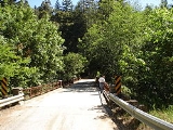
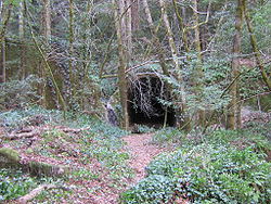
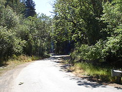 Wrights has so completely disappeared that today no trace remains, except the ruins of the old tunnel. Some building foundations and debris from the town can still be found in the dense woods. Satellite and ground photographs show thick overgrowth and forest on the site. The surrounding area is now only sparsely settled. The name of the community lives on in "Wrights Station Road", which runs through the redwood forest from Morrill Road to Cathermola Road (also known as Metcalf Road on some maps), north of Summit Road. Wrights Station Road crosses Los Gatos Creek on an historic bridge with iron railings (possibly dating from the 1920s), ending at the site of the town. Lake Elsman, a reservoir, is near the site of Wrights. Several miles of the original Los Gatos - Santa Cruz narrow gauge railroad have been preserved in Santa Cruz County and trains operate year-round as a tourist attraction known as the Santa Cruz, Big Trees and Pacific Railway
.
that affected much of northern California, Oregon, and Washington. The maximum annual snowfall was 10.6 inches (26.9 cm) in 1974. Some temperature records for Wrights exist, showing a record high of 102°F on August 5, 1978.
Santa Clara County, California
Santa Clara County is a county located at the southern end of the San Francisco Bay Area in the U.S. state of California. As of 2010 it had a population of 1,781,642. The county seat is San Jose. The highly urbanized Santa Clara Valley within Santa Clara County is also known as Silicon Valley...
in the Santa Cruz Mountains
Santa Cruz Mountains
The Santa Cruz Mountains, part of the Pacific Coast Ranges, are a mountain range in central California, United States. They form a ridge along the San Francisco Peninsula, south of San Francisco, separating the Pacific Ocean from San Francisco Bay and the Santa Clara Valley, and continuing south,...
, at , near Summit Road, east of State Route 17. It is located on the north bank of Los Gatos Creek
Los Gatos Creek (Santa Clara County, California)
The Los Gatos Creek runs 24 miles in California through Santa Clara Valley Water District's Guadalupe Watershed from the Santa Cruz Mountains northward through the Santa Clara Valley until its confluence with the Guadalupe River in downtown San Jose...
.
The National Weather Service
National Weather Service
The National Weather Service , once known as the Weather Bureau, is one of the six scientific agencies that make up the National Oceanic and Atmospheric Administration of the United States government...
maintained a cooperative weather station on the site of Wrights until May 31, 1986, which recorded rainfall and snowfall. The weather station was 1600 feet (487.7 m) above sea level. The location is on the San Andreas Fault
San Andreas Fault
The San Andreas Fault is a continental strike-slip fault that runs a length of roughly through California in the United States. The fault's motion is right-lateral strike-slip...
, according to the U.S. Geological Survey, and it experienced considerable damage in the 1906 San Francisco earthquake
1906 San Francisco earthquake
The San Francisco earthquake of 1906 was a major earthquake that struck San Francisco, California, and the coast of Northern California at 5:12 a.m. on Wednesday, April 18, 1906. The most widely accepted estimate for the magnitude of the earthquake is a moment magnitude of 7.9; however, other...
. Geologists observed a lateral displacement of 4.6 feet (1.4 m) at Wrights. Wrights is now considered a ghost town
Ghost town
A ghost town is an abandoned town or city. A town often becomes a ghost town because the economic activity that supported it has failed, or due to natural or human-caused disasters such as floods, government actions, uncontrolled lawlessness, war, or nuclear disasters...
.
Wrights is one of a number of ghost towns in the Santa Cruz Mountains that flourished during the last half of the nineteenth century. Laurel
Laurel, California
Laurel is a ghost town in Santa Cruz County, California, United States, in the Santa Cruz Mountains. The exact location of Laurel is latitude 370700N, longitude 1215755W; the decimal degrees are latitude 37.11667, longitude -121.96528...
, Wrights, Glenwood
Glenwood, California
Glenwood, California, is a ghost town in Santa Cruz County. It is located at coordinates ; decimal degrees: latitude 37.10833, longitude -121.98556. It is 891 feet above sea level....
, and Clems
Clems, California
Clems, California is a ghost town in Santa Cruz County with an elevation of 790 feet . It is located a latitude 37055N, longitude 1215947W; decimal degrees: latitude 37.09806, longitude -121.99639....
declined when the Los Gatos
Los Gatos, California
The Town of Los Gatos is an incorporated town in Santa Clara County, California, United States. The population was 29,413 at the 2010 census. It is located in the San Francisco Bay Area at the southwest corner of San Jose in the foothills of the Santa Cruz Mountains...
-Santa Cruz
Santa Cruz, California
Santa Cruz is the county seat and largest city of Santa Cruz County, California in the US. As of the 2010 U.S. Census, Santa Cruz had a total population of 59,946...
railroad ceased operations in March 1940. Later in 1940, Patchen
Patchen, California
Patchen, California, is a ghost town on the Old Santa Cruz Highway, east of State Route 17 in the Santa Cruz Mountains in Santa Clara County.-History:...
was bypassed and isolated by the construction of State Route 17; since the late 1960s it has been a Christmas tree ranch. Alma
Alma, California
Alma is a ghost town in Santa Clara County in California, United States. It lies beneath the waters of the Lexington Reservoir above Los Gatos. The location is latitude 37.18N and longitude 121.98W. It was 551 feet above sea level....
and Lexington
Lexington, California
Lexington, California is a ghost town in Santa Clara County, now submerged by the Lexington Reservoir. It is located at latitude 34°11'47"N, longitude 121°59'14"W; decimal degrees: latitude 37.19639, longitude -121.98722. Originally located along Los Gatos Creek, the town was 550 feet above sea...
were submerged in Lexington Reservoir in 1952, along State Route 17 above Los Gatos.
History
Burrell, California
Burrell, California was an early settlement in Santa Cruz County near the summit of the Santa Cruz Mountains, south-southeast of Wrights. It was named for Lyman John Burrell, who settled there in the early 1850s. There was a Burrell School, which was later abandoned...
near the summit, and he maintained commercial orchards of fruit trees and grapes. The small community that sprouted around this stop on the railroad became known as Wright's Station, or simply Wrights. The Rev. Wright was the patriarch of a large family that had moved to California from Ohio and the younger brother of the well-known abolitionist Elizur Wright. One of his sons, Frank Vincent Wright, later married Susie Davis, the daughter of SPCRR president Alfred Davis, and another son, Sumner Banks Wright, moved to southern California and established a town in the San Bernardino mountains known as Wrightwood, today a ski resort.
A post office was established at Wrights in 1879, and the railroad was completed in 1880 from Los Gatos, along the Los Gatos Creek, to Wrights Station, about a mile east of Patchen. During the construction of the main railroad tunnel (between Wrights and Laurel
Laurel, California
Laurel is a ghost town in Santa Cruz County, California, United States, in the Santa Cruz Mountains. The exact location of Laurel is latitude 370700N, longitude 1215755W; the decimal degrees are latitude 37.11667, longitude -121.96528...
), a strong flow of natural gas
Natural gas
Natural gas is a naturally occurring gas mixture consisting primarily of methane, typically with 0–20% higher hydrocarbons . It is found associated with other hydrocarbon fuel, in coal beds, as methane clathrates, and is an important fuel source and a major feedstock for fertilizers.Most natural...
was encountered, and an explosion followed, which resulted in the death of thirty-two Chinese
Chinese people
The term Chinese people may refer to any of the following:*People with Han Chinese ethnicity ....
workers. The main leak was subsequently stopped, but gas continued to escape in small quantities. The extent of the supply was unknown. U.S. Geological Survey maps from 1919 show the railroad running from Los Gatos to Santa Cruz, with stops in Alma
Alma, California
Alma is a ghost town in Santa Clara County in California, United States. It lies beneath the waters of the Lexington Reservoir above Los Gatos. The location is latitude 37.18N and longitude 121.98W. It was 551 feet above sea level....
, Wrights, Laurel
Laurel, California
Laurel is a ghost town in Santa Cruz County, California, United States, in the Santa Cruz Mountains. The exact location of Laurel is latitude 370700N, longitude 1215755W; the decimal degrees are latitude 37.11667, longitude -121.96528...
, Glenwood
Glenwood, California
Glenwood, California, is a ghost town in Santa Cruz County. It is located at coordinates ; decimal degrees: latitude 37.10833, longitude -121.98556. It is 891 feet above sea level....
, Clems
Clems, California
Clems, California is a ghost town in Santa Cruz County with an elevation of 790 feet . It is located a latitude 37055N, longitude 1215947W; decimal degrees: latitude 37.09806, longitude -121.99639....
, Zayante
Zayante, California
Zayante is a census-designated place in Santa Cruz County, California. It is a residential area located on Zayante Creek. Zayante sits at an elevation of . The 2010 United States census reported Zayante's population was 705.-History:...
, Eccles
Eccles, California
Eccles, California is a ghost town in Santa Cruz County, near Felton, east of Ben Lomond. It was near where Lompico Creek flows into Zayante Creek....
, Felton
Felton, California
-2010:The 2010 United States Census reported that Felton had a population of 4,057. The population density was 891.2 people per square mile . The racial makeup of Felton was 3,691 White, 25 African American, 29 Native American, 69 Asian, 11 Pacific Islander, 60 from other races, and 172 from...
, and Scotts Valley
Scotts Valley, California
Scotts Valley is a small city in Santa Cruz County, California, United States, about thirty miles south of downtown San Jose and six miles north of Monterey Bay, in the upland slope of the Santa Cruz Mountains. As of the 2010 census, the city population was 11,580...
. There were a series of tunnels, including a 6200 feet (1,889.8 m) tunnel between Wright and Laurel, most of which were later blocked when the railroad ceased opeations. Wrights itself had a benchmark
Benchmark (surveying)
The term bench mark, or benchmark, originates from the chiseled horizontal marks that surveyors made in stone structures, into which an angle-iron could be placed to form a "bench" for a leveling rod, thus ensuring that a leveling rod could be accurately repositioned in the same place in the future...
elevation of 896 feet (273.1 m).
Wrights Station was an important shipping point for extensive fruit growing areas in the Santa Cruz mountains. By the 1890s, there were about 3200 acres (12.9 km²) under cultivation. The soil consists largely of disintegrated sandstone
Sandstone
Sandstone is a sedimentary rock composed mainly of sand-sized minerals or rock grains.Most sandstone is composed of quartz and/or feldspar because these are the most common minerals in the Earth's crust. Like sand, sandstone may be any colour, but the most common colours are tan, brown, yellow,...
and clay
Clay
Clay is a general term including many combinations of one or more clay minerals with traces of metal oxides and organic matter. Geologic clay deposits are mostly composed of phyllosilicate minerals containing variable amounts of water trapped in the mineral structure.- Formation :Clay minerals...
, and has the appearance, particularly on the hilltops, of the "white ash
White Ash
For another species referred to as white ash, see Eucalyptus fraxinoides.Fraxinus americana is a species of Fraxinus native to eastern North America found in mesophytic hardwood forests from Nova Scotia west to Minnesota, south to northern Florida, and southwest to eastern...
" soil of the Fresno
Fresno, California
Fresno is a city in central California, United States, the county seat of Fresno County. As of the 2010 census, the city's population was 510,365, making it the fifth largest city in California, the largest inland city in California, and the 34th largest in the nation...
raisin
Raisin
Raisins are dried grapes. They are produced in many regions of the world. Raisins may be eaten raw or used in cooking, baking and brewing...
district.
Vineyards were planted, providing grapes for commercial wine
Wine
Wine is an alcoholic beverage, made of fermented fruit juice, usually from grapes. The natural chemical balance of grapes lets them ferment without the addition of sugars, acids, enzymes, or other nutrients. Grape wine is produced by fermenting crushed grapes using various types of yeast. Yeast...
producers, such as Almaden Vineyards
Almaden Vineyards
Almaden Vineyards is a winery located in Escalon and Madera, California. They claim to be California's oldest winery.Their original location was at the Old Almaden Winery south of San José between Los Gatos and Almaden...
and Paul Masson
Paul Masson
Paul Masson was an early pioneer of California viticulture and successful popularizer of Californian sparkling wine.-Biography:...
. There was a thriving timber
Timber
Timber may refer to:* Timber, a term common in the United Kingdom and Australia for wood materials * Timber, Oregon, an unincorporated community in the U.S...
industry, too, utilizing the redwoods of the Santa Cruz Mountains. All utilized the railroad. Wrights Station was one of the small settlements that grew up along the railroad.
Alice Matty and her father, Antone, came to Wrights in 1880 from San Francisco. Her father was originally from the Maritime Alps region of France. Antone Matty worked in the general store for eight years. An overheated stove in the town's hotel started a fire in 1885 that leveled the entire settlement. While Wrights was being rebuilt, Antone ran the store from a boxcar parked on the railroad siding.
In 1887, journalist Josephine McCracken visited Wrights (as it was commonly called), reporting the community had "a depot, hotel, store, post office, blacksmith shop, besides a number of decidedly ugly and disgraceful-looking Chinese stores and wash houses. Fir-crowned mountains frowned down upon it, and the hideous black mouth of the great tunnel close by is always wide open, with the evident and determined intention of swallowing up the train — engine, cars, and all — as it approached from the San Francisco side."
By 1888, Antone Matty had saved enough money to buy the store, and by 1896 he owned the town. Since the Matty family had six children, Matty helped to organize a school district, and soon the town had a school. The Wright School was a shingle-walled building with a belfry, and was in operation until 1928. Matty became a member of the Santa Clara Valley
Santa Clara Valley
The Santa Clara Valley is a valley just south of the San Francisco Bay in Northern California in the United States. Much of Santa Clara County and its county seat, San José, are in the Santa Clara Valley. The valley was originally known as the Valley of Heart’s Delight for its high concentration...
Pioneer Association, and later joined the Sempervirens Club
Sempervirens Club
Sempervirens Fund, originally established in 1900 as Sempervirens Club, is California's oldest land conservation organization. Founder Andrew P. Hill's goal was to preserve the old-growth forest that became Big Basin Redwoods State Park, the first California state park in 1902...
, a conservation organization devoted to saving the redwoods.
Southern Pacific Railroad
Southern Pacific Railroad
The Southern Pacific Transportation Company , earlier Southern Pacific Railroad and Southern Pacific Company, and usually simply called the Southern Pacific or Espee, was an American railroad....
bought the narrow gauge SPCRR railroad and decided to take advantage of a craze for picnic excursion trains. They opened a short spur line along the creek at Wrights. They named the area "Sunset Park", and began hauling trainloads of passengers into the Santa Cruz mountains. Unfortunately, according to contemporary reports, the visitors gathered armloads of ferns and wildflowers, left a trail of discarded litter strewn along the railroad right-of-way, and kicked out the passenger car windows on the return trip. The 1906 earthquake ended the excursion trains and Sunset Park.
Besides the numerous farms in the region, a number of homes were constructed, many of which were destroyed in the April 18, 1906, earthquake. A fissure opened under the house at the Morrell Ranch, throwing the structure from its foundation and splitting it in two. The quake also destroyed a number of bridges, damaged the tunnels, and twisted the rails, as Robert Iacopi and William Bronson recounted in their published accounts. Another large fissure opened in the dirt road near the blacksmith shop. About 400 feet from the eastern end of the 6200 feet (1.9 km) railroad tunnel (between Wrights and Laurel), a 5 feet (152.4 cm) offset occurred, badly damaging the tunnel. Fences were also split.
Alice Matty, her sisters Teresa and Anna, and her three brothers grew up at Wrights. When the station agent, Mr. Hunter, was replaced in the 1900s, Alice was appointed to take over his position, becoming the first woman station agent hired by Southern Pacific in California. Bruce MacGregor described the job: "The Wrights station agent inked in waybills for loadings of hay, beans, prunes and figs, cargo that would fill two or three boxcars a day. The lumber freighting eclipsed all other cargoes combined." There was a daily freight train from Alameda
Alameda, California
Alameda is a city in Alameda County, California, United States. It is located on Alameda Island and Bay Farm Island, and is adjacent to Oakland in the San Francisco Bay. The Bay Farm Island portion of the city is adjacent to the Oakland International Airport. At the 2010 census, the city had a...
. Several local freights and mixed trains (passengers and freight) passed through Wrights every day on their way to Santa Cruz or San Jose.
Besides preparing waybills, Alice Matty was the telegrapher and the ticket agent. She handled the manual signal levers that threw the switches when trains needed to be taken off the main line and placed on sidings. Located in the bottom of a canyon, Wrights had its share of flash floods, rock slides, and forest fires. Alice frequently had to telegraph for a repair crew to clear rocks from the track, or shore up a sagging roadbed after a heavy storm. Increasing rail traffic resulted in an increase in the number of accidents.
Alice Matty never married; she stayed at Wrights with her father, who lived until 1922. In later years she worked at the Bank of America
Bank of America
Bank of America Corporation, an American multinational banking and financial services corporation, is the second largest bank holding company in the United States by assets, and the fourth largest bank in the U.S. by market capitalization. The bank is headquartered in Charlotte, North Carolina...
in Los Gatos, when it was located at the corner of Main Street and Santa Cruz Avenue.
The railroad was rebuilt after the earthquake, only to cease operations in 1940 following a landslide caused by heavy rains in February of that year; this disaster further contributed to the decline of Wrights (the post office had already closed two years before). The routing of State Route 17 away from Wrights in 1940 also led to the village's demise. Sadly, in that same year Arbor Villa, the Wright family home, which was still occupied by Clara Wright, the youngest daughter of James Richards Wright, burned to the ground and was never rebuilt.
Legacy
Santa Cruz, Big Trees and Pacific Railway
The Santa Cruz, Big Trees and Pacific Railway is a freight and heritage railroad in Northern California.It uses diesel locomotives to haul excursion trains over an route between Olympia, California and an interchange with the Union Pacific Railroad at the Santa Cruz Wye, though the line is now...
.
Weather station
The National Weather Service cooperative station, which operated on the site of Wrights until 1986, primarily recorded rainfall and snowfall. Based on those observations, Wrights had an average annual rainfall of 46.09 inches (117.1 cm) and an average annual snowfall of 1.2 inches (3 cm). The maximum annual rainfall was 87.65 inches (222.6 cm) in 1983 and the minimum was 17.88 inches (45.4 cm) in 1976. The greatest 24-hour rainfall was 13.79 inches (35 cm) on October 12, 1962, during the famous Columbus Day stormColumbus Day Storm of 1962
The Columbus Day Storm of 1962 was an extratropical cyclone that ranked among the most intense to strike the United States Pacific Northwest since at least 1948, likely since the January 9, 1880 "Great Gale" and snowstorm...
that affected much of northern California, Oregon, and Washington. The maximum annual snowfall was 10.6 inches (26.9 cm) in 1974. Some temperature records for Wrights exist, showing a record high of 102°F on August 5, 1978.